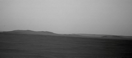
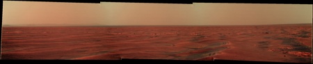
Here's the current view from that pancam sequence, with about 8x vertical stretch - or astoogmatism.
Some details in the distant plains are becoming visible.
Phil
Click to view attachment
(PS - oops, put it in the wrong thread!) - Fixed that for you - Mod
PPS - hint to camera guys - a full 360 horizon pancam strip would be nice right about now!
Full Version: Distant vistas
It's taken me a while to get this finished and convince myself that it has a possibility of being right. 
Anyway, here is may attempt to match the features in Fredk's stacked image with a reprojected CTX image:
Click to view attachment
James
Anyway, here is may attempt to match the features in Fredk's stacked image with a reprojected CTX image:
Click to view attachment
James
Another tour-de-force James! I think you're spot on. I've been comparing Nirgal's 3D renderings with the latest view and your identifications fit with my tentative impressions.
BTW have you had a go at those peaks beyond (to the right of) Iazu yet? That seems to be the only part of the horizon for which you haven't provided a definitive key.
BTW have you had a go at those peaks beyond (to the right of) Iazu yet? That seems to be the only part of the horizon for which you haven't provided a definitive key.
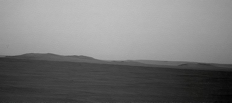
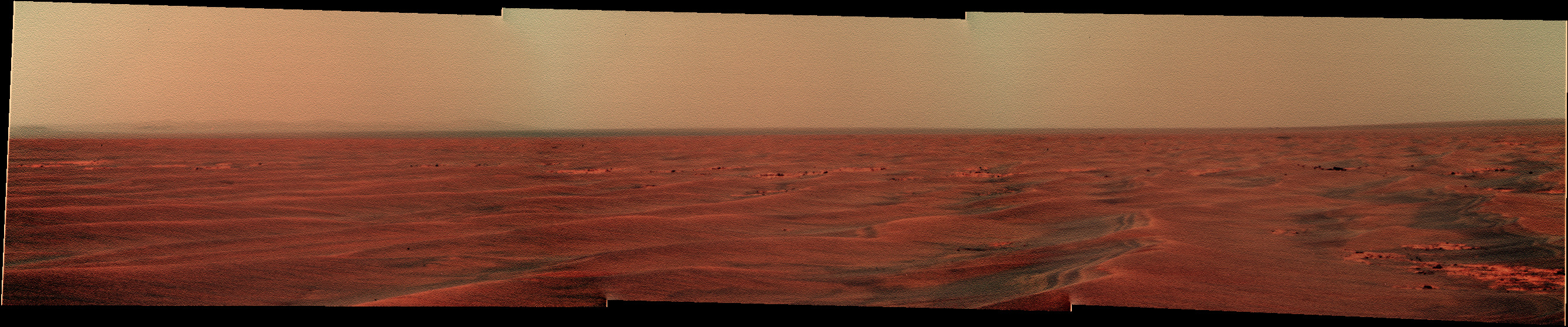
And the ground-hugging haze (particulate, actually) layer is becoming more distinct now.
--Bill
--Bill
This is about the dark feature on the plains in front of Iazu that shows up very clearly on Phil's horizon stretch. That image also shows that the surface the feature is sitting on curves downward to the right into an invisible depression. I have found features on the CTX that may correspond and will try to post an image somehow shortly.
QUOTE (ngunn @ May 20 2010, 10:15 PM) 
BTW have you had a go at those peaks beyond (to the right of) Iazu yet? That seems to be the only part of the horizon for which you haven't provided a definitive key.
No, had even less free time than usual lately! I think I may have a rare few hours at home without a toddler running around tomorrow afternoon so maybe then.

OK the CTX feature I was referring to in my last post is near the centre of the attached low-res crop, with the big depression (also dark) to the SW of it. Unfortunately I can't seem to manage to post a high-res crop, but when zoomed in it looks like a confused jumble of rocks maybe from a muliple impact.
EDIT; I look forward to that James - didn't mean to nag.
EDIT; I look forward to that James - didn't mean to nag.
I wasn't sure which thread would be best to post this in. Feel free to move it.
Some things I have been experimenting with recently are simulated, oblique, long-baseline anaglyphs. This first one is looking SSE from near Victoria. Opportunity's route path is yellow, with the projected, future path in blue, as per Eduardo's maps. Endeavour, Iazu, and the two large unnamed craters beyond are visible in this view. Vertical relief is exaggerated 3X to bring out some of the subtle topography along the path. It is a very wide image and will appear best on wide screens or dual monitor setups.
Click to view attachment
Here is one more with a better view of the future path toward Endeavour. As in the last one, the vertical exaggeration is 3X. The view is toward the SE.
Click to view attachment
Click to view attachment
WOW, CR!!!  Those are incredible views, thanks!
Great idea; this perspective makes a lot of difference in visualizing the route, at least for me.
Those are incredible views, thanks!Great idea; this perspective makes a lot of difference in visualizing the route, at least for me.
Very nice !
Cosmic - you rock
Neat. I think what you've done is to take a pair of GoogleMars images with Tesheiner's route overlay, in a perspective view and with vertical exaggeration, to make an anaglyph image. Good work.
I'm getting over an eye problem nowadays and can't do stereo images at all well. But from eyeballing the image here, it looks like after the Eastward Turn, the route goes over a slight rise on the way to Santa Maria (mini-Endurance). This seems to be a mismatch with Tim Parker's DEM/Topo map from 2638.pdf , which suggests a steadily decreasing slope. I may be wrong, but this has been bugging me...
--Bill
Same thing's been bugging me. If the rise was there we wouldn't be seeing what we're seeing towards Endeavour now. We're already looking slightly down at the base of those rim hills, so there can't be anything higher in the way. I do think the perspective anaglyphs are great though.
Thanks, everyone, for your kind encouragement. Bill, you're right. I did it with Google Earth/Mars.
I'm glad you guys mentioned the topography discrepancy. I had meant to explain that, but totally forgot. The method depends on the topographic model in Google Mars, which is, for the most part, MOLA. MOLA data point spacing is fairly coarse. I forget the details, but near the equator I think the sample density is on the order of 1 point per kilometer or less. Some areas, like Victoria Crater, incorporate HiRise or other DEMs which have have data points much more closely spaced.
I don't recall the source of data used in Tim's map, but it was made from a more densely sampled DEM than the MOLA maps. So, until someone convinces Google to add some higher resolution elevation data to the model, we a mostly stuck with MOLA for this sort of thing. At least, this is what I think is the reason for the discrepancies. This is the same reason why parts of the rims of crater like Endeavour appear smoother than they probably are.
I just wanted tomake sure that I wasn't imagining a topographic discrepancy using cyclopean stereo.
But reflecting back, a couple of weeks ago Ant posted wide L1 Pancam Philo-vision panorama that suggested either a rise to the East, or level ground with a dropoff to the North and South. There may be a basis for what we're seeing.
http://www.unmannedspaceflight.com/index.p...st&p=159441
That would make an interesting polar pan. I'll fiddle with it, but it may take a while since I've not done one in a long time-- if someone beats me to it, fine...
--Bill
I did a quick check and discovered that the Google map and Tim's map are both based on MOLA data, so I am at a loss to explain the difference. I can imagine some differences if the two maps were gridded and contoured with different conditions, but the difference we're seeing here seems beyond that. Looking at the Google data more carefully, it appears that it is not so much that there is a rise to the east, but rather that the area near where the route turns east is anomalously low. The low area is roughly the size of the area of influence of a MOLA data point, so perhaps at some time a point was deemed in error and removed from the dataset or corrected.
Tim is probably the one who can best shed light on this.
Tim is probably the one who can best shed light on this.
Gridding software is, by necessity, voodoo. Which explains it all. On Tim's contour map, there is the suggestion of a several-meter depression around Victoria, due to the elevation aperture used. Take it as the most reasonable approximation...
I think Tim uses/used ARC/INFO or an ESRI product, which is generally good but has quirks. Still better than a plane table and stadia rod...
--Bill
I think Tim uses/used ARC/INFO or an ESRI product, which is generally good but has quirks. Still better than a plane table and stadia rod...
--Bill
The 'horizon' in front of Endeavour is close enough that we can see individual bumps there. As we've been moving southward it should be possible to triangulate the distance to that 'horizon' quite accurately. I think this would help a lot with undersanding the lie of the land. If nobody does that I may have a go later, but others could do a much better job I'm sure.
This is a quick-and dirty Polar Pan derived from Ant's rectangular pan in Post#363. I dodn't see a strong topographic high to the East as I thought I did with the rectangular pan, as much as a definite low of the near horizon to the South.
--Bill
--Bill
Hard to pass after Fred and Astro0 versions but I wanted to try by myself with the Keith's Image Stacker, a software that I use normaly for my astronomy work.
Sol 2238 Endeavour rim - 16 x L6 and 1 R1 pics. Laplacian pyramid sharpen.
And a coulour version with L2/R1 stacking :
Sol 2238 Endeavour rim - 16 x L6 and 1 R1 pics. Laplacian pyramid sharpen.
And a coulour version with L2/R1 stacking :
Great post by Emily on the long trek's clay-rich destination. There's loads to say about it and though it's been discussed before maybe another thread on this is warranted? For now, here's the link: http://www.planetary.org/blog/article/00002509/
A great article indeed by Emily, as usual!
Seems as if the phyllosilicates are generally concentrated on the top of Endeavour's rim. If mountaineering al a Spirit proves not possible for any reason, I wonder if they're going to be aggressively looking for landslide deposits at the base of the hills?
Seems as if the phyllosilicates are generally concentrated on the top of Endeavour's rim. If mountaineering al a Spirit proves not possible for any reason, I wonder if they're going to be aggressively looking for landslide deposits at the base of the hills?
I think we're on the same wavelength nprev. Phyllosilicdates of ancient origin would presumably be exposed at the surface in two kinds of places. Places recently cleared of more recent material by a landslide, and places newly surfaced by clay-rich landslide material. The maps in Emily's post suggest both, else why would the top of the ridge resemble patches at the bottom? On a world like Earth where active processes are going on the presence of something on the surface means it's recently exposed. The timescale on Mars may be longer but I think the same general rule applies.
This is standard practice in field geology. In an ideal world you have access (walking or otherwise) to the entire geological section. In the real world, you don't always. At a hillside, a cliff, a mine highwall or a quarry face you can many times see the rock strata but aren't able to get a sample of the rocks in-place (or in situ). The next best thing is to move along on your traverse and look at samples of float, or rocks that have broken off of the cliff face and tumbled down to your level. Landslides can be used but tend to be a bit chaotic. Using one's best professional eyeball and judgement and plucky sense of intuition you can frequently place a rock in it's proper location in the section, or at least nearest 5-10 meters of rock or show that it came from somewhere thataway.
It isn't perfect but if it's all you have to work with...
--Bill
It isn't perfect but if it's all you have to work with...
--Bill
That was an excellent article by Emily. As nprev noted, she always writes very well.
While we are discussing Endeavor's rim and the smectite deposits discovered there, it might help to start looking at the rim more closely. Here is a HiRise anaglyph of the NW portion of the rim; the part that Oppy is driving toward. I used PSP-010341-1775 and PSP-010486-1775 respectively as the left and right images.
Has anyone calculated the slope on this hill to determine if the rover would have a chance of climbing it?
Click to view attachment
On the topic of sampling phyllosilicates up the hill, landslides (if they exist) would certainly bring the rocks down to accessible levels, but I'd guess ejecta would do a better job of spreading them about, albeit in smaller quantities. The rover has become quite good a spotting ejecta blocks whose composition differs from the local generalty.
I think it's useful here to link back to this discussion in Nirgal's thread:
http://www.unmannedspaceflight.com/index.p...st&p=156307
http://www.unmannedspaceflight.com/index.p...st&p=156307
QUOTE (Nirgal @ Mar 2 2010, 09:44 PM)
Upon a request posed over at the "Dust Avalanche" thread I did a small 3D DEM study of an area near Endeavour Crater based on a single image cropped from PSP_010341_1775.

Click image to see the whole gallery. The first image shows the DEM rendered from above with the same lighting conditions as the original image so as to give an idea of the accuracy of the 3D reconstruction (note, however, that the accuracy decreases somewhat when the DEM is lit from other than the original lighting direction).
The generated DEM consists of 8192x4096 = 32 million polygons with true 3D (means no texturing) post spacing at full HiRISE resolution (28.6 cm/pixel ).
Here is my usual Disclaimer: the rendered DEMs are intended for visualization only. The absolute heights are not calibrated and there may be distortions due to albedo variations.
QUOTE (CosmicRocker @ May 25 2010, 08:48 AM)
Has anyone calculated the slope on this hill to determine if the rover would have a chance of climbing it?
For any of the hills visible to Oppy, you can measure the slopes transverse to the line of sight directly from the pancams - no need to calculate. I find that the steepest sustained slopes on all the visible bits are consistently around 17 or 18 degrees. There are approaches that are considerably less steep. There are also a few short stretches that approach 30 degrees. But generally that sounds quite doable - Duck Bay was in the 15 to 20 degree range. Of course this also depends on the looseness of the surfaces and the condition of Oppy at the time...
Click to view attachment
I just have to second that those renderings you made, cosmicrocker, are really great! - Super-duper-top-notch stuff! - The future trek really comes to life.
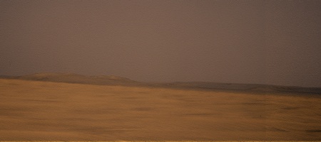
Yikes, it looks like we had some dust blow through on sol 2245. Compare this view of Iazu on 2245:
http://qt.exploratorium.edu/mars/opportuni...7M1.JPG?sol2245
with this view from 2246:
http://qt.exploratorium.edu/mars/opportuni...1M1.JPG?sol2246
According to the latest Oppy update, tau on 2245 was 0.421, up a little bit from around 0.32 - 0.35 in recent weeks.
This is a good reminder that as spring and summer approach and dust levels rise, we likely won't have such spectacular views of Endeavour/Iazu as we do now until next winter. (Or until we're much closer, whichever comes first!)
Yes, notice the same thing. This peak of Tau was pretty fast.
The color mosaic showing how fusy the atmosphere was :
The color mosaic showing how fusy the atmosphere was :
QUOTE (ngunn @ May 25 2010, 03:58 AM)
I think it's useful here to link back to this discussion in Nirgal's thread: ...
Thanks for reminding me of Nirgal's astounding shape-from-shading work. I see that I had missed some of his best renderings.
QUOTE (fredk @ May 25 2010, 09:56 AM)
For any of the hills visible to Oppy, you can measure the slopes transverse to the line of sight ...
Thanks, fredk. That will work for me as an initial approximation. Sometimes, the most intuitively obvious things escape my attention. QUOTE (Oersted @ May 25 2010, 02:04 PM)
I just have to second ...
Thank you very much. I had a lot of fun making them. There are some very nice views of Spirit's locale, also. When I get some time to finish it, I'll post something there.
This is about the distance to the near 'horizon' in front of the Endeavour hills. I've measured the change in position of two features relative to the background hills, which I've assumed to be at 12km. I used R1 images from May 14th and today's (26th May) exploratorium updates. What I don't know is the transverse baseline length between the two vantage points. If the baseline's 50 m the distance is 2500m. If the baseline's 100m the distance is 4200m. Those estimates are bigger than I would have guessed but they seem to fit with the change in slope on the contour map.
EDIT: Re dust levels - I see that the Mule Ears are nicely visible in the latest images. I've been watching them clear then fade then clear over recent weeks.
EDIT: Re dust levels - I see that the Mule Ears are nicely visible in the latest images. I've been watching them clear then fade then clear over recent weeks.
A similar but even more approximate triangulation estimate for the distance to the dark feature I discussed in post 407, on the plain in front of Iazu, comes out at around 10 km. That's about the right order for the CTX feature I suggested as ID but I don't know if the azimuth checks out exactly.
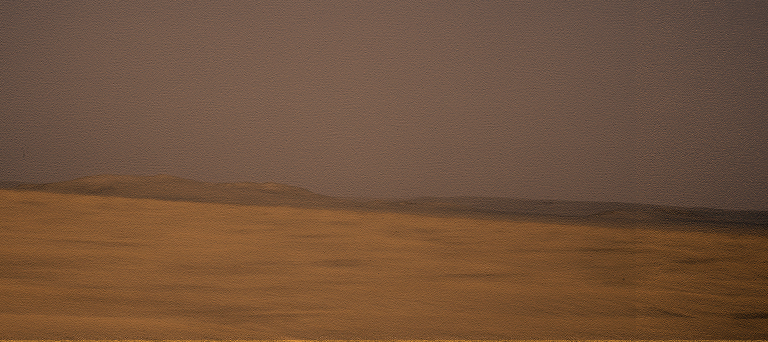
Checking on the MER Filenames Decoder (fantastic resource which everyone should have bookmarked, if only to prevent the embarrassment of "spotting" something "new" on an old image, like I've done in the past!: http://www.greuti.ch/oppy/html/filenames_ltst.htm ) that "dusty" image was taken on Tue May 18th. Today's Exploratorium images include shots taken on Sat May 22nd, which show a much clearer view...
Click to view attachment
Click to view attachment
Wow that IS clear. I think I can see smectite.

When are we going to get this NASA "high resolution view" then, do you reckon?
QUOTE (ngunn @ May 26 2010, 09:55 AM)
What I don't know is the transverse baseline length between the two vantage points.
From the sols for the two vantage points, you should be able to measure the baseline from Tesheiner's map.
QUOTE (Stu @ May 26 2010, 06:40 AM)
When are we going to get this NASA "high resolution view" then, do you reckon?
Probably after the new employees over at JPL finally get their desks organized and learn where the bathroom is. Then we'll start seeing some really nice image products.
I'm sure Tim Parker will be doing that job, and he already knows where the bathroom is. But he may be tied up with MSL site mapping these days.
Phil
Phil
QUOTE (fredk @ May 26 2010, 03:36 PM)
you should be able to measure the baseline
Yes, since Stu has helpfully provided the missing link in the form of that great filename decoder I'll probably have a go. Is it safe to assume that pancams taken on driving days are taken at the end of the drive?
Unfortunately exploratorium seems a bit intermittent - working this morning but not right now.
EDIT: Estimating distances and angles from the map I think my calculation with the 50m baseline was about right. This would place the near horizon at 2500m or thereabouts, somewhere near the 1395 contour. That's about 20 m lower than we are now so we're looking down at it at an elevation angle of minus 0.4 degrees. If that's right Santa Maria will not come into view until we've travelled that 2500 m. Hopefully the lip of the Endeavour depression will be visible sooner.
QUOTE (ngunn @ May 26 2010, 04:23 PM)
Is it safe to assume that pancams taken on driving days are taken at the end of the drive?
Not necessarily. You can be sure by comparing with the local times that the ultimate hazcams were taken - those always follow the drive. You can also compare the site and drive numbers - they'll change after the drive.
To complement CosmicRocker's gorgeous 3D view, I've stitched together a bunch of 1:1 IAS Viewer zoom views of the region of the Endeavour rim Oppy will be arriving at (I think?)...
http://twitpic.com/1sfwck
Fascinating place
http://twitpic.com/1sfwck
Fascinating place
What looks like large chunks of ejecta dug up by the small crater on the south end might make interesting targets.
Click to view attachment
Click to view attachment
Simulated HiRISE views of what we're all dearly hoping to see eventually... scale as accurate as I can make it...
Oppy approaching the foot of the hills...
Click to view attachment
And Oppy at the summit of the closest Faraway Hills...
Click to view attachment
Oppy approaching the foot of the hills...
Click to view attachment
And Oppy at the summit of the closest Faraway Hills...
Click to view attachment
QUOTE (centsworth_II @ May 30 2010, 12:48 PM)
What looks like large chunks of ejecta dug up by the small crater on the south end might make interesting targets.
Those are pretty impressive-sized blocks, too...
Click to view attachment
QUOTE (Stu @ May 30 2010, 02:13 PM)
Oppy approaching the foot of the hills...
cool simulations, Stu !
here are some (very quick&dirty) 3D DEMs made from it:
Click to view attachment
Click to view attachment
Click to view attachment
Very nice Nirgal! Have to be honest, my views aren't so much 'simulations' as 'messing about withs'
Have to be honest, my views aren't so much 'simulations' as 'messing about withs'
QUOTE (Stu @ May 30 2010, 05:12 AM)
...I've stitched together a bunch of 1:1 IAS Viewer zoom views of the region of the Endeavour rim Oppy will be arriving at...
http://twitpic.com/1sfwck
Fascinating place
http://twitpic.com/1sfwck
Fascinating place
That's excellent, Stu. Thanks!
That gave me an idea. I've taken your mosaic and have overlaid upon it the CRISM color map from the phyllosilicate paper I posted about earlier. I think it helps to see the CRISM mineralogical anomalies overlain on the high resolution image you provided. In this image ferromagnesian phyllosilicates (smectites) are shades of red and polyhydrated sulfates are shades of cyan.
Click to view attachment
Correction: I actually lifted the CRISM colors from the image that Emily posted on her blog. Her image was larger than the one in the pdf and it was not annotated.
This is a "lo-fi" version of our main content. To view the full version with more information, formatting and images, please click here.