It's not easy to figure out where to divide threads, but we just had a drive on sol 72 which I think we could say signifies the beginning of the traverse to the south and the start of regular science operations. Originally I expected a clean break with helicopter operations but we are not getting such an obvious dividing point.
So I am taking it on myself to start a new thread for the exploration mission. If the timing seems wrong people can let me know.
Phil
Full Version: South from the landing site, sols 72-237
Here is my version for the Sol-72 Post-drive panorama. I kind of went your way Phil in projecting the polar, or what you say is called 'Circular'. Let me know if you want me to do these in the future over the previous polar projection that I used.


That's very nice, James. If you feel like doing that I would be happy to see it.
It looks to me like there is a nice path to the SSW from here to a smooth area which would be the next helicopter landing zone.
Phil
It looks to me like there is a nice path to the SSW from here to a smooth area which would be the next helicopter landing zone.
Phil
QUOTE (Phil Stooke @ May 4 2021, 12:35 AM) 
It's not easy to figure out where to divide threads, but we just had a drive on sol 72 which I think we could say signifies the beginning of the traverse to the south and the start of regular science operations. Originally I expected a clean break with helicopter operations but we are not getting such an obvious dividing point.
So I am taking it on myself to start a new thread for the exploration mission. If the timing seems wrong people can let me know.
Phil
So I am taking it on myself to start a new thread for the exploration mission. If the timing seems wrong people can let me know.
Phil
I think by SOL would be best :
Sol 0 - 100
Sol 101 - 200
etc
Good call, Phil. The shift to a new phase of the journey has definitely happened.
Onward!
Onward!
Phobos (I think) imaged by skycam twice a few minutes apart overnight on sol 73:
https://mars.nasa.gov/mars2020-raw-images/p...5_0000LUJ01.png
https://mars.nasa.gov/mars2020-raw-images/p...5_0000LUJ01.png
https://mars.nasa.gov/mars2020-raw-images/p...5_0000LUJ01.png
https://mars.nasa.gov/mars2020-raw-images/p...5_0000LUJ01.png
No sign of any skyglow in those images - the ND mask should make that easy if it was there. Insight ICC, which is optically identical to skycam, was able to see some skyglow at night back at sol 370, which we speculated was due to Phobos-shine. Perhaps it's just a matter of exposure time.
ICC also caught Sirius on several occasions, so skycam should be able to too, and the skycam plan was to measure stellar fluxes at night.
ICC also caught Sirius on several occasions, so skycam should be able to too, and the skycam plan was to measure stellar fluxes at night.
Another drive on sol 73, looks to be SSE
Click to view attachment
Click to view attachment
Two large boulders, cracked vertically on sol 73, next to each other. Coincidence ? Perhaps the same material, and similar shape, responding to thermal stresses ? With a preexisting weakness in similarly oriented planes ?
Click to view attachment
https://mars.nasa.gov/mars2020-raw-images/p...1_01_295J01.png
https://mars.nasa.gov/mars2020-raw-images/p...8_13_195J01.png
Click to view attachment
https://mars.nasa.gov/mars2020-raw-images/p...1_01_295J01.png
https://mars.nasa.gov/mars2020-raw-images/p...8_13_195J01.png
The Sol-73 Post-drive Navcam pan's. I'm now aligning the circular/polar image to North-top which I'm using the terrific Marslife.org website to quickly determine that. I'm not aligning the regular panorama yet. 

Circular/Polar

Circular/Polar
Thanks, James, very useful. Looking for new science targets or looking for a path to the south? I wish we were getting more reports on activity, as we do with Curiosity. Maybe later...
Phil
Phil
My attempt at the Sol-73 Navcam sky pan. There was some lovely clouds visible in the raws, I might have butchered the heck out of them during blending.
Ah well, I tried...
Looking forward to Damia's version. Her last one was cleaner.

Ah well, I tried...
Looking forward to Damia's version. Her last one was cleaner.
Yes, hard pictures.
Her.
My version of this spectacular panoramic
Postcard maybe ?
QUOTE
His last one was cleaner.
Her.
My version of this spectacular panoramic
Postcard maybe ?
It's wonderful to see a full sky colour panorama from Mars. Congratulations to all concerned. It would be great for projecting on a planetarium (or other) dome.
QUOTE (Ant103 @ May 5 2021, 12:35 AM)
Her.
My apologies, Damia.
Have they announced that they have chosen the southern route rather than the north route?
Yes, in a press conference a few days ago.
Phil
Phil
The discussion of the route south starts at 28:30 of the video: Science route (zone) south
Here is a screen shot. I added the 1 mile long bar. The length of the red-marked zone was said to be a little more than a mile. Also stated was that the science campaign in this area, including sample collection, would last several hundred sols. So a year or more before the rover heads toward the delta.
Click to view attachment
QUOTE (centsworth_II @ May 5 2021, 10:08 PM)
The discussion of the route south starts at 28:30 of the video: Science route (zone) south
Here is a screen shot. I added the 1 mile long bar. The length of the red-marked zone was said to be a little more than a mile. Also stated was that the science campaign in this area, including sample collection, would last several hundred sols. So a year or more before the rover heads toward the delta.
Here is a screen shot. I added the 1 mile long bar. The length of the red-marked zone was said to be a little more than a mile. Also stated was that the science campaign in this area, including sample collection, would last several hundred sols. So a year or more before the rover heads toward the delta.
That kind of implies a much longer mission is anticipated than 2 Earth years.
QUOTE (MahFL @ May 6 2021, 01:02 AM)
That kind of implies a much longer mission is anticipated than 2 Earth years.
Hopefully! Curiosity, Perseverance's older sibling, is coming up on 9 years and still going strong. From the description in the video, the area they will be spending "several hundred sols" in may be even better suited than the delta for finding biological signatures.
Sol 74 saw a large 116 image mosaic of the local rock assembly by MCZ. The great Marslife.org does a great job of merging, and I took the liberty to post the result here for quick reference to help locate individual frames from the raw images which is otherwise quite difficult:

I hope that is ok. It may be one of the largest outcrop mosaics for Perseverance sofar, so perhaps this patch will be studied in some detail ?
I hope that is ok. It may be one of the largest outcrop mosaics for Perseverance sofar, so perhaps this patch will be studied in some detail ?
QUOTE (centsworth_II @ May 6 2021, 02:53 AM)
Hopefully! Curiosity, Perseverance's older sibling, is coming up on 9 years and still going strong. From the description in the video, the area they will be spending "several hundred sols" in may be even better suited than the delta for finding biological signatures.
I do think it is a good idea to spend extended time out here since two years seemed very conservative, and chances are that once the rover leaves the area it will never come back. The location is very interesting due to a quieter depositional environment in the possibly shallow lake, proximity to a contact between mappable geological units, and the early observations of a diversity of rock types.
There are also groups which are very interested to visit the area just west outside of the crater which was scheduled for the second year, I believe. So it will be interesting to see if the several hundred days here in the outer delta, lake bottom area, will affect the time available at the actual delta remnants. I cannot really imagine it would but perhaps some kind of agreement between groups was necessary.
QUOTE (PaulH51 @ May 7 2021, 05:48 AM)
Hardware check-out on sol 75
Nice piece of hardware! This is a part of the sampling and caching system I guess? The entry of the carousel?
QUOTE (neo56 @ May 7 2021, 03:08 PM)
Nice piece of hardware! This is a part of the sampling and caching system I guess? The entry of the carousel?
It appears so
Another engineering checkout?
This time close to midnight using the white LED banks on WATSON? Imaging the external interface of the 'Bit carousel.
Note the raw image page for these images does not provide the focus count or which LED banks were on / off like we get on MSL. That will probably have to wait until they set up formal JSON pages as the image pipeline matures?
Click to view attachment
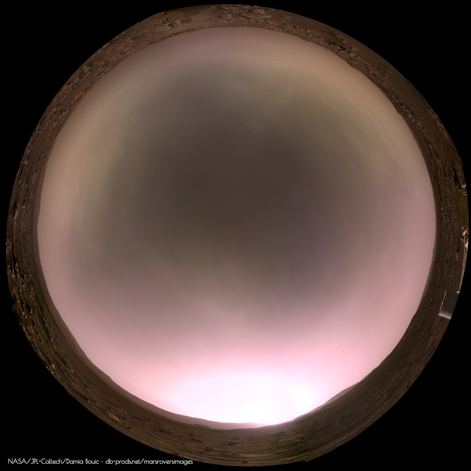
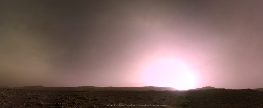
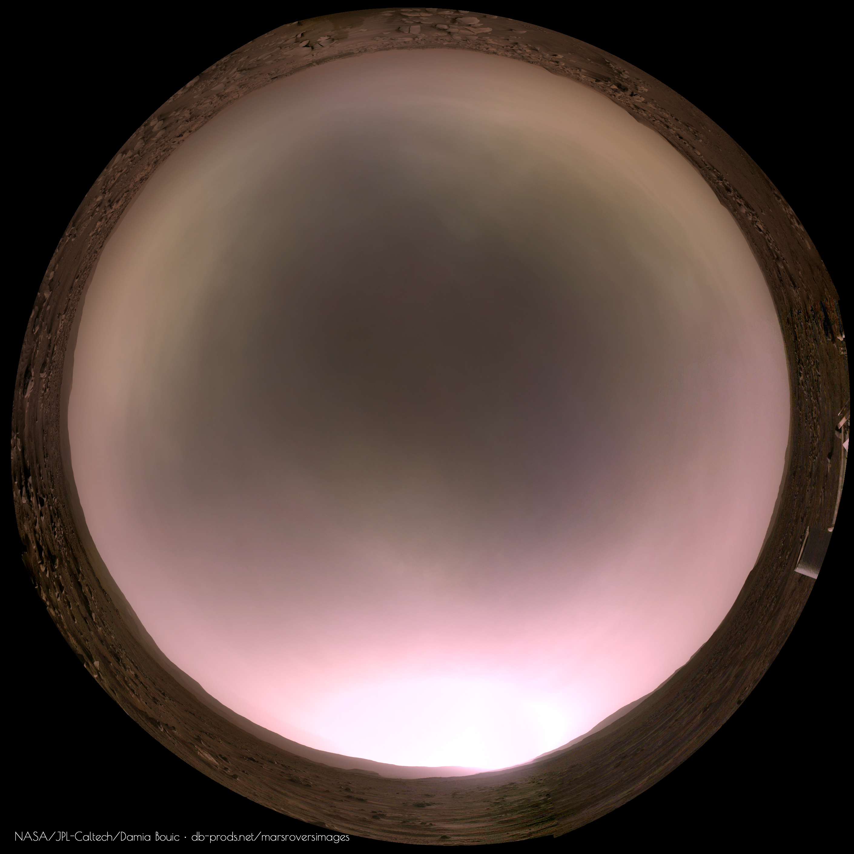
Sol 77, an other all-sky panoramic. This time at midsol.

Supercam laser scratches the surface? Sol 74/75.
Click to view attachment
Click to view attachment
Nice work Damia! Here is my version. That's not easy to stitch the zenith picture without evident control points.
Your vignetting correction is really good, I've still adjustements to provide.


Your vignetting correction is really good, I've still adjustements to provide.
When the Ingenuity helicopter made its 5th flight last Friday, two faint dust devils were recorded in the same field of view !
They were located well behind Ingenuity. Enjoy
Click to view attachment
They were located well behind Ingenuity. Enjoy
Click to view attachment
The MastCam-Z panorama taken Sol 78 is gorgeous.
Here is a section processed in 3D.
Look at all those rolling ridges with rocks perched on top of sand dunes.
This is the very romantic view of Mars "a la Bradbury " we all love to see!
What a great camera the MastCam-Z is !
=>> I hope, they will soon take a similar panoramic picture, but at sunrise and/or at sunset with looooooong shadows which makes the landscape even more beautiful and the relief come out even better
CONGRATULATIONS to the MastCam-Z team
Enjoy
Click to view attachment
Click to view attachment
QUOTE (neo56 @ May 12 2021, 05:48 PM)
My take on this awesome shot of Ingenuity in front of two distant dust devils, and in animation.
Congratulations Thomas for this nice work of yours

I'm assuming that this was a 'characterization test' of the rover's arm at a 'teach-point' in front of the rover, with what appears very similar to the canned bricks of organic check material carried by Curiosity (but sadly not used so far)
If that assumption is correct I guess they could puncture the can and return a sample to earth in a sealed sample tube to ensure there were no earthly organics in it as a cross check, if so it could be the first sample acquired / cached?
Or it could be like MSL, only to be used in the event PIXL detects organics?
Does anyone know if either of those assumption are correct?
Google search using organic check material etc has failed to provide an answer for this rover.
Click to view attachment
QUOTE (vikingmars @ May 12 2021, 12:30 PM)
The MastCam-Z panorama taken Sol 78 is gorgeous.
Larger panorama to show the above section in a larger context 3D. Enjoy
Click to view attachment
Nice anaglyph Olivier!
Here is a photomontage of SuperCam/RMI and MCZ-L pictures taken on sol 80.

Here is a photomontage of SuperCam/RMI and MCZ-L pictures taken on sol 80.
sherloc context imager return some curious pictures of a somewhat textured stone, like a fabric, see sol 83 Click to view attachment and Click to view attachment . I see small white dots regularly spaced between interrupted white lines, horizontal and vertical. Is this a known mineral or cristal ? Did someone know what it may be ? Maybe it's only my imagination ?
I don't see it 15 minutes earlier. Maybe something happened.
It's just possible something happened....
https://www.hou.usra.edu/meetings/lpsc2017/pdf/2839.pdf
"Survey mode. Initial observations will be performed on an abraded patch in survey mode. The laser will fire raster over a 7x7 mm area with 200μm spacing to gen- erate 1225 spectra arranged in a 35x35 point grid. A Raman/fluorescence spectrum is acquired within 1 sec at each point. These spectra can be averaged together to get bulk organic/mineral abundances over the entire scanned area."
QUOTE (Deimos @ May 15 2021, 05:36 PM)
I don't see it 15 minutes earlier. Maybe something happened.
Thank you Deimos, you are right. Maybe some turret's hardware foot print ? (from sherloc ACI itself ? ; by the way, I presume we see three laser holes on the right of larges pictures).
QUOTE (djellison @ May 15 2021, 05:53 PM)
It's just possible something happened....
https://www.hou.usra.edu/meetings/lpsc2017/pdf/2839.pdf
"Survey mode. Initial observations will be performed on an abraded patch in survey mode. The laser will fire raster over a 7x7 mm area with 200μm spacing to gen- erate 1225 spectra arranged in a 35x35 point grid. A Raman/fluorescence spectrum is acquired within 1 sec at each point. These spectra can be averaged together to get bulk organic/mineral abundances over the entire scanned area."
https://www.hou.usra.edu/meetings/lpsc2017/pdf/2839.pdf
"Survey mode. Initial observations will be performed on an abraded patch in survey mode. The laser will fire raster over a 7x7 mm area with 200μm spacing to gen- erate 1225 spectra arranged in a 35x35 point grid. A Raman/fluorescence spectrum is acquired within 1 sec at each point. These spectra can be averaged together to get bulk organic/mineral abundances over the entire scanned area."
A 35 x 35 point grid ! Doug thank you. that is certainly the 'fabric', and on the right it's probably 3 laser holes from chemcam...
Sol 84: L-NavCam looking back after a short drive (West) to site number 4
Click to view attachment
Edit (drive direction corrected, thanks Phil)
Click to view attachment
Edit (drive direction corrected, thanks Phil)
Sol 82 early morning MastCam-Z pictures in 3D.
I wish that a sunrise or a sunset panorama will be taken soon in color and in 3D : this would be gorgeous to see !
Click to view attachment
I wish that a sunrise or a sunset panorama will be taken soon in color and in 3D : this would be gorgeous to see !
Click to view attachment
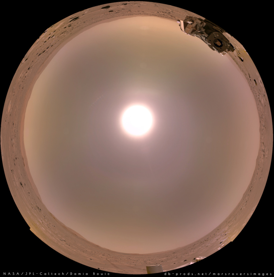
I like very much those 'sky dynamics' pictures taken early morning. Enjoy !
Click to view attachment
Click to view attachment
This is the partial pan from sol 84 which gave me the location for the map.
Phil
Click to view attachment
Phil
Click to view attachment
I'm awaiting all of the Navcam images to come down for the latest drive for the 360. While waiting, I assembled the binned 2x2 tiled mosaic looking over the deck-to the horizon from Sol-84.

Sol 82 Hazcam animation of drill stabilization test (push-up)
Click to view attachment
Click to view attachment
Colorful multispectral Mars on Sol 77
AClick to view attachment BClick to view attachment CClick to view attachment
A) Mastcam-Z left eye, filter 0, original RGB
B) Mastcam-Z left eye, filter 0 (RGB channels) and filters 1 to 6 converted to RGB using principal component analysis and color space transformation.
The sky was excluded from the principal component calculation, but the resulting coefficients were applied to it, too (no manual coloring).
C) Mastcam-Z right eye, infrared filters 1 to 6, without filter 0.
Because of the only slight differences in the infrared reflectances of the Martian landscape, the calculated principal components are strongly influenced by inhomogeneities in the filter flat fields, slight pixel shifts (less than one pixel), and probably chromatic aberration. Only the first and second components were used here. The unique blue color of the cliff face and rock fragments on the talus below the cliff in this image suggests a mineralogical composition distinct from that of the dunes and boulders in the foreground and the crater wall in the background.
This is a "lo-fi" version of our main content. To view the full version with more information, formatting and images, please click here.