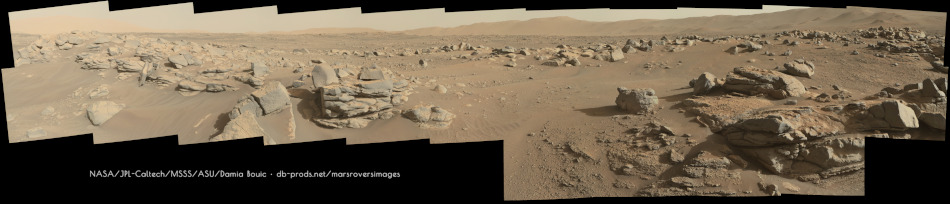
Here is a partial sol 168 panorama:
Click to view attachment
Full Version: South from the landing site, sols 72-237
Another nice drive on sol 170 (site:6, drive:892)
2-tile Navcam roughly assembled in MS-ICE
Click to view attachment
2-tile Navcam roughly assembled in MS-ICE
Click to view attachment
Sol 169 Mastcam-Z
Here and there are very thin coatings on the rocks, in other places some patches with smooth surface and thin layering
Click to view attachment Click to view attachment Click to view attachment Click to view attachment Click to view attachment
Here and there are very thin coatings on the rocks, in other places some patches with smooth surface and thin layering
Click to view attachment Click to view attachment Click to view attachment Click to view attachment Click to view attachment
Tau, it strikes me that the thing these rocks have in common is movement and impact. In the last image of the series it seems to me that the two areas arrowed fit together and were internal, possibly along a dust filled crack in a larger rock that fractured when falling from a higher position. The third image could be impact compression from rocks falling from the imaged ledge. Alternatively it may be thin sections of tachylite (basaltic glass).
QUOTE (serpens @ Aug 13 2021, 04:58 AM) 
. . . movement and impact . . .
I rather suspect that the coatings and patches were created in calm conditions, probably as fracture fillings, maybe even with the presence of water.
This smooth coating in the picture below reminds me of coatings when water with dissolved minerals runs over rock surfaces. For better visibility, the coating is colored blue in the right image.
Click to view attachment
By the way, when I first saw the raw image, I wondered why parts of this rock were out of focus and others were not. Until I recognized the outlines of the smooth coating that creates the out-of-focus effect.
Sol 171: L-Navcam mosaic site:6, drive:1450
4-tile mosaic (raw colours) roughly stitched using MS-ICE
Click to view attachment
4-tile mosaic (raw colours) roughly stitched using MS-ICE
Click to view attachment
QUOTE (tau @ Aug 13 2021, 11:03 AM)
I rather suspect that the coatings and patches were created in calm conditions, probably as fracture fillings, maybe even with the presence of water.
This smooth coating in the picture below reminds me of coatings when water with dissolved minerals runs over rock surfaces. For better visibility, the coating is colored blue in the right image.
This smooth coating in the picture below reminds me of coatings when water with dissolved minerals runs over rock surfaces. For better visibility, the coating is colored blue in the right image.
It does remind me of travertine. Though given the local chemistry I'd think more like a calcium sulfate (gypsum or some vsriation).
--Bill
One of the 'All Sky NavCam frames from sol 171, captured a nicely lit section of Séítah's sand dunes (ripples?) on the north side of the rover.
This is a roughly processed / cropped version where I have crudely adjusted the lens distortion
Click to view attachment
This is a roughly processed / cropped version where I have crudely adjusted the lens distortion
Click to view attachment
Reminiscent of Oppy's great trek across the dune fields of Meridiani...
QUOTE (PaulH51 @ Aug 14 2021, 04:06 AM)
One of the 'All Sky NavCam frames from sol 171, captured a nicely lit section of Séítah's sand dunes (ripples?) on the north side of the rover.
This is a roughly processed / cropped version where I have crudely adjusted the lens distortion
Click to view attachment
This is a roughly processed / cropped version where I have crudely adjusted the lens distortion
Click to view attachment
How tall are those sand dunes?
Panorama taken with Mastcam-Z Right on sol 168 (focal length set to 48mm), at 16:20 LMST.

After another long drive we now have a few more images. The next science waypoint (layered rocks) is only ~50 meters due west of the rover
Sol 171: 4-tile R-Navcam mosaic, roughly assembled in MS-ICE
Click to view attachment
Sol 171: 4-tile R-Navcam mosaic, roughly assembled in MS-ICE
Click to view attachment
And somewhat reminiscent of Oppy getting stuck...
--Bill
--Bill
Sol 173 LMastcam-Z:
Click to view attachment
Click to view attachment
Some lovely images of Deimos over Seitah captured by Perseverance Rover on sol 173 will likely form a wonderful animation.
Here is one roughly de-greened
Click to view attachment
Here is one roughly de-greened
Click to view attachment
A mosaic of 2 Navcam tiles, roughly assembled in MS-ICE after a drive on sol 173 closer to 'Artuby'
Click to view attachment
Click to view attachment
Here is the Sol-173 Navcam panorama. I wish I had more time to work on these full 360 panoramas. Other priorities that are going on in my life kind of preclude that. Also these binned 2x2 image tiles are a lot of work and even more so, merging them seamlessly into a 360 degree pan. I am trying to work out an optimal and fast workflow for these.

Polar

Polar
Deimos imaged with Navcam Left at 7:05 pm LMST. Vignetting, distorsion and colors corrected.

Sol 174 LMastcam-Z:
Click to view attachment
Click to view attachment
A drive on Sol 175 brings Perseverance Rover closer to the layered outcrop dubbed 'Artuby'.
In one version I have crudely adjusted the Navcam tiled mosaic in an attempt to correct the lens distortion of the wide angle lens (roughly assembled in MS-ICE)
Click to view attachment Click to view attachment
In one version I have crudely adjusted the Navcam tiled mosaic in an attempt to correct the lens distortion of the wide angle lens (roughly assembled in MS-ICE)
Click to view attachment Click to view attachment
Panorama taken with Mastcam-Z Left on sol 174 at about 10:45 LMST, with two cropped versions.


Sol 171 SuperCam Remote Micro-Imager with Mastcam-Z context
Click to view attachment Click to view attachment
Click to view attachment Click to view attachment
Sol 175 SuperCam Remote Micro-Imager image series no. 1 with Mastcam-Z context
Click to view attachment Click to view attachment
Click to view attachment Click to view attachment
Sol 175 SuperCam Remote Micro-Imager image series no. 2 with Mastcam-Z context
Click to view attachment Click to view attachment
Click to view attachment Click to view attachment
Sol 175 SuperCam Remote Micro-Imager, part 3.
Some more raw images have been published online. Here is the previously missing part and a Mastcam-Z context image of all so fare published sol 175 SuperCam RMI images.
Click to view attachment Click to view attachment
Some more raw images have been published online. Here is the previously missing part and a Mastcam-Z context image of all so fare published sol 175 SuperCam RMI images.
Click to view attachment Click to view attachment
Sol 163 Mastcam-Z multispectral images
1) Left eye filter 0 (RGB) raw image
2) Left eye filters 0 to 6 multispectral principal components
3) Right eye filters 0 to 6 multispectral principal components
1 Click to view attachment . . 2 Click to view attachment . . 3 Click to view attachment
1) Left eye filter 0 (RGB) raw image
2) Left eye filters 0 to 6 multispectral principal components
3) Right eye filters 0 to 6 multispectral principal components
1 Click to view attachment . . 2 Click to view attachment . . 3 Click to view attachment
The tall outcrop in the Sol 175 Mastcam.image is Artuby (see the current Route Map above). And in the foreground is an expression of the the Parallel Lineations, along with Micro Imager mosaics.
We may spend some time here.
--Bill
We may spend some time here.
--Bill
QUOTE (Bill Harris @ Aug 20 2021, 04:44 AM)
We may spend some time here.
--Bill
--Bill
The rover was tilted at ~20 degrees, they may have considered it too steep for contact science?
They drove away from Artuby during sol 177, heading further WNW between the ridge and the sand dunes (est >85 meters)
Click to view attachment
Back in the saddle again - did I say saddle? I meant harness. (Virtual Mars Bar if you know where that comes from without googling it)
This is the sol 175 panorama in circular form. Very tricky to fit this one together. I wish we had just a single full frame Navcam for each sector instead of four quadrants individually stretched. It makes my job much harder.
Anyway, already moved on now - more later and a map update soon. Tomorrow will be the first PDS release for Perseverance and I am hoping the Analyst's Notebook will be up and running right away, with lots of new target names.
Phil
Click to view attachment
SOL 177
Interesting lines/cracks (related to the raised ridges?)
Adaptive Equalization to increase contrast
GIF
Click to view attachment
Interesting lines/cracks (related to the raised ridges?)
Adaptive Equalization to increase contrast
GIF
Click to view attachment
QUOTE (PaulH51 @ Aug 19 2021, 05:37 PM)
The rover was tilted at ~20 degrees, they may have considered it too steep for contact science?
Undoubtedly. I saw that rock but didn't perceive that talus with slip failures. Good place to get stuck.
But this was our first encounter with a good exposure of the Lineations. We got multispectral and micro images here and we'll encounter it again up-trek (or would that be up-rove?).
--Bill
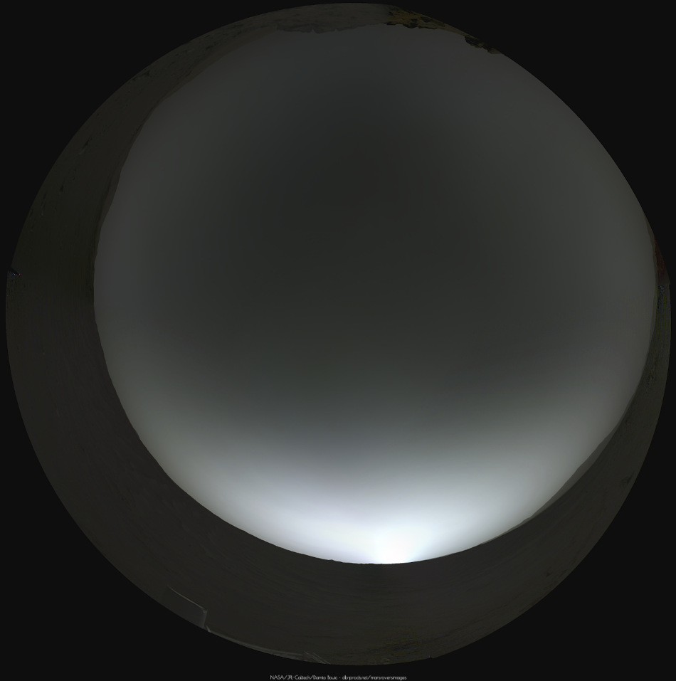
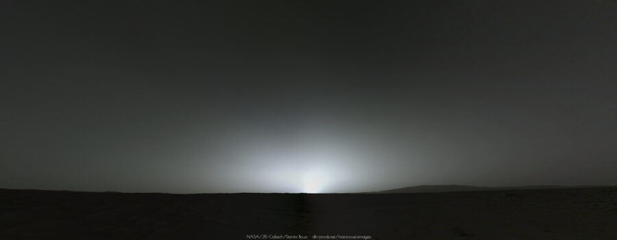
Sol 177 sunrise picture. The first ever of its kind. The sun is overexposed yes, but we have everything, like the blue haze around it, and how the diffusion of light is made through the atmosphere.
Also, Postcard version :
And a forgotten panoramic, MastcamZ at 48mm, on Sol 168 :

Also, Postcard version :
And a forgotten panoramic, MastcamZ at 48mm, on Sol 168 :
Sol 169 Mastcam-Z multispectral detail of an layered outcrop
1) Raw image left eye filter 0 (RGB)
2) Left eye filters 1 to 6 PCA (without filter 0, because shadows changed between exposures)
1 Click to view attachment . . 2 Click to view attachment
1) Raw image left eye filter 0 (RGB)
2) Left eye filters 1 to 6 PCA (without filter 0, because shadows changed between exposures)
1 Click to view attachment . . 2 Click to view attachment
Congratulations Ant103 for this superb work of yours
Here is the Sol 168 partial panorama in 3D (reduced version to fit in the Forum).
It's an impressive landscape indeed! Enjoy
Click to view attachment
Here is the Sol 168 partial panorama in 3D (reduced version to fit in the Forum).
It's an impressive landscape indeed! Enjoy
Click to view attachment
Really nice work Damia on stitching these Navcam pictures! No seam, perfect job 
Here is my take with only 3 of the 5 pictures.

Here is my take with only 3 of the 5 pictures.
There seems to be a slight asymmetry in the sky glow, as though something over the horizon is casting a shadow on the atmosphere just to the left of the sun.
John
John
Sol 175 LMastcam-Z:
Click to view attachment
Click to view attachment
QUOTE (john_s @ Aug 20 2021, 07:33 PM)
There seems to be a slight asymmetry in the sky glow, as though something over the horizon is casting a shadow on the atmosphere just to the left of the sun.
I think it can be the result of a sligthly incorrect flatfielding correction in my case.
Right - if you look at the original frames:
https://mars.nasa.gov/mars2020-raw-images/p...1_01_295J01.png
https://mars.nasa.gov/mars2020-raw-images/p...1_01_295J01.png
the sun is near the edge of the frames so the shape of the glow will be sensitive to vignetting (and uncorrectable when the glow is saturated).
https://mars.nasa.gov/mars2020-raw-images/p...1_01_295J01.png
https://mars.nasa.gov/mars2020-raw-images/p...1_01_295J01.png
the sun is near the edge of the frames so the shape of the glow will be sensitive to vignetting (and uncorrectable when the glow is saturated).
Looks like you're right. My dream of Martian crepuscular rays is shattered...
John
John
PDS release today - the Analyst's notebook is not yet ready (alas) but among the goodies is a table of Supercam targets. This is a very condensed list (omitting duplicate names, long distance imaging and calibration shots). I think these are all LIBS targets (except 'Heli' which is the helicopter, presumably, though I have not checked yet) but some might be just RMI images not labeled long distance.
Phil
-----------------------------------
sol targetname
12 Maaz
15 Tselchee
16 Yeehgo
28 Iina
30 Keyah
37 Hedgehog
38 Barrel
41 Beavertail
46 Prickly_Pear
46 Peppermint
51 Tselhbahih
56 Bidziil
56 Abinih
60 Hozho
61 Dzilh
64 Dii
67 Lhikan
69 Di_ch_iizh
69 Heli
71 Hadahastsaa
71 Tsewozitah
72 A_koo
72 Tselhgai
73 Baa_big_han
76 Heli
78 Chal
79 Tsehzhin
79 Tsetah
82 Ahil_hane
83 Nataani
84 Sei
84 Naakih
86 Hoolhnili
86 Naatsiilid
87 Hastah_tsaadah
88 Tsostid_tsaadah
88 Tseebi_tsaadah
89 Taa-Ihaaih
89 Hastah_tsaadah
Mission update (blog) from Kenneth Farley dated August 20, 2021
'Roubion - The Problematic Weathered Paver Stone Perseverance Failed to Core'
Adresses: 'Rubion', Citadelle, and the possibility of continuing the westward trek toward South Seítah, then heading out the way we came, and possibly have another go at coring CFFR.
LINK
EDIT
Drive on Sol 178: 2-tile end-of-drive Navcam (MS-ICE)
Click to view attachment
QUOTE (john_s @ Aug 20 2021, 04:39 PM)
Looks like you're right. My dream of Martian crepuscular rays is shattered...
John
John
Keep looking. It'll show up.
Here is a partial 1x3 pan from Sol-178.

A simple chart to show the elevation changes (since landing) after each drive.
The data is extracted from the geojson files available in the interactive mission map
Click to view attachment
The data is extracted from the geojson files available in the interactive mission map
Click to view attachment
This is a "lo-fi" version of our main content. To view the full version with more information, formatting and images, please click here.