Core hole #3 Watson animation #2:
Click to view attachment
Full Version: South from the landing site, sols 72-237
QUOTE (HSchirmer @ Sep 24 2021, 01:29 AM) 
How do we guess the size of ash particles on Mars?
I know they calculated that raindrops could be about 1/8th larger on Mars-
I know they calculated that raindrops could be about 1/8th larger on Mars-
How about we just agree the definition of volcanic ash (<2mm) holds. The size distribution in the range will vary, after all it does between volcanoes on Earth but the real question is what would have been the size of particles deposited in Jezero or the watershed as a function of distance from the as yet unidentified source. Unfortunately there are three unknown variables for that calculation; atmospheric density and viscosity as well as the nature of prevailing winds. Larger particles preferentially fall out close to the source and it would be reasonable to assume that ash deposited in our area of interest would be fine.
And it may not be ash emplaced from airfall. It could be ash from a pyroclastics flow, or from fluvial transportation or from from erosion from an ash deposit.
In the animations of the coreholes I see reddish-tan streaks, which imply weathering of minerals under wet conditions, which is consistent with with their description of the findings.
--Bill
In the animations of the coreholes I see reddish-tan streaks, which imply weathering of minerals under wet conditions, which is consistent with with their description of the findings.
--Bill
Sol 211 LMastcam-Z:
Click to view attachment
Click to view attachment
1) Stereoscopic grain-size measurement yields a prevailing diameter of 1.2 to 1.8 mm for the visible grains in this sol 206 Mastcam-Z image
2) Multispectral false color image, sol 208 Mastcam-Z left eye filters 0 to 6, principal components
3) Multispectral false color image, sol 208 Mastcam-Z right eye filters 0 to 6, principal components
4) Context image, sol 206 Front Left Hazard Avoidance Camera A
The source of the coarse grains seems to be weathering of rocks like the one in the center of image 1 and at the lower left corner of 2 and 3.
Some of the flake-like rock fragments show a thin layering.
Click to view attachmentClick to view attachmentClick to view attachmentClick to view attachment
QUOTE (Bill Harris @ Sep 24 2021, 04:44 AM)
And it may not be ash emplaced from airfall. It could be ash from a pyroclastics flow, or from fluvial transportation or from from erosion from an ash deposit....
Agree. And just to be complete, it could also consist of impactoclastic particulate matter (flow or fall), from cratering uphill. This might be difficult to distinguish from volcanic material, given that it also would be composed of it.
dburt
And impactoclastic, also (nicer term than base-surge). And remember, weathering, erosion and transportation are so slow compared to terrestrial processes. We have no idea of the age of this surface.
--Bill
--Bill
Sol 211 SuperCam RMI with Mastcam-Z context and sol 210 Navcam context.
SuperCam image now with improved self-made flatfield correction, based on eight SuperCam images from sol 206, where the zenith of the Martian sky was captured.
Color correction is not possible without further calibration, so the colors of the rock here are somewhat arbitrary.
The blue color in the Navcam image is only set as a marker.
Click to view attachment Click to view attachment nClick to view attachment
The olivine rich deposit in the watershed is believed to be a result of deep excavation by the Isidis impact. As it overlays some of the megabreccia it may be base surge, impact related melt flows, fallout which could include ash size particles or a combination of these. The deposits in Jezero appear to have been deposited in the crater from early inflow and the delta material overlays the olivine rich deposits. Seitah is olivine rich and potentially has been eroded to the olivine deposit level subsequent to embayment by the mafic floor. If so the latest sample would represent the earlier deposits in a closed system before the formation of the delta.
Sol 213 SuperCam RMI with sol 211 Mastcam-Z context and sol 210 Navcam context
Click to view attachment Click to view attachment Click to view attachment
Click to view attachment Click to view attachment Click to view attachment
Sol 210 Mastcam-Z raw image, left eye filters 1 to 6 multispectral principal components (false colors), and anaglyph
Click to view attachment Click to view attachment Click to view attachment
Click to view attachment Click to view attachment Click to view attachment
That would make a great album cover!
QUOTE (JRehling @ Sep 27 2021, 10:50 PM)
That would make a great album cover!
Perfect for the next David Bowie / Ziggy Stardust / Halloween Jack / Thin White Duke- anniversary album.
QUOTE (tau @ Sep 27 2021, 07:48 AM)
Sol 210 Mastcam-Z raw image, left eye filters 1 to 6 multispectral principal components (false colors) , and anaglyph
Click to view attachment
Click to view attachment
I'm not sure if this is an effect of the aeolian erosion, but I'm seeing a hint of cross-bedding here.
--Bill
I thought the same. Also a hint of soft sediment deformation on the middle left - maybe perhaps.
QUOTE (serpens @ Sep 27 2021, 08:32 PM)
I thought the same. Also a hint of soft sediment deformation on the middle left - maybe perhaps.
I see the bed boundaries, which may be defined by a finer-grained drape, fairly well expressed. Some other images even looked like there may have been some ripples preserved there. On the whole, it looks like cm-dm scale beds, with some vertical surfaces expressing the bed boundaries and others completely obscuring them.I've been fooled by some of these exposures into thinking the beds were more homogenous and thicker, but tracing them laterally, I could see the cm-dm spacing of internal bed boundaries. I do see the areas that you and Bill are talking about, which stick out because they are different from the thin/tabular bedding that's pervasive.
I'm sticking with my subaqueous sediment gravity flow/turbidite interpretation until I see something inconsistent.
Sol 214 SuperCam Remote Micro Imager, context still unclear.
I don't remember that Perseverance photographed a similar rock like this before.
Especially the small white (semitransparent?) grain(?) to the left of the center and the wavy layer boundaries puzzle me.
Click to view attachment
I don't remember that Perseverance photographed a similar rock like this before.
Especially the small white (semitransparent?) grain(?) to the left of the center and the wavy layer boundaries puzzle me.
Click to view attachment
I'm wondering if they'll take the next sample pair here, or if not, why not. It seems like the only reason not to would be an expectation that this same stuff will be found, in clearer context, somewhere upslope.
QUOTE (tau @ Sep 28 2021, 09:39 AM)
Sol 214 SuperCam Remote Micro Imager, context still unclear.
Especially the small white (semitransparent?) grain(?) to the left of the center and the wavy layer boundaries puzzle me.
Especially the small white (semitransparent?) grain(?) to the left of the center and the wavy layer boundaries puzzle me.
May be "an undigested bit of beef, a blot of mustard, a crumb of cheese", or just an odd mineral grain. Let's look for more as we traverse the slope.
Does anyone have a clue about the proposed route? I'd guess north-northeastward toward the landing point, then westward toward the delta scarps.
--Bill
I thought the intent was to go back the way they came and have a second attempt at a sample from Roubion and then go around Seitah to the North?
I initially thought this looked like festoons, but probably not.
I was thinking they were planning to return to Rubion, but the current (apparent).track puts the big dunes of Seitah between the Rover and Rubion. The "conjunction holiday" is upon us and we'll see what develops late in October.
That feature does resemble Festoons, but these wind-eroded outcrops are ripe for paredoila. Look for more examples!
--Bill
That feature does resemble Festoons, but these wind-eroded outcrops are ripe for paredoila. Look for more examples!
--Bill
Sol 214 SuperCam context found in a sol 213 Mastcam-Z image with 34 mm focal length.
SuperCam RMI image now with scale bars based on stereoscopy. Grain-size measurement gives an average diameter of 1.8 mm.
Hopefully, we see an image of this rock with 110 mm focal length.
Click to view attachment Click to view attachment Click to view attachment
SuperCam RMI image now with scale bars based on stereoscopy. Grain-size measurement gives an average diameter of 1.8 mm.
Hopefully, we see an image of this rock with 110 mm focal length.
Click to view attachment Click to view attachment Click to view attachment
QUOTE (Bill Harris @ Sep 29 2021, 06:48 AM)
I was thinking they were planning to return to Rubion, but the current (apparent).track puts the big dunes of Seitah between the Rover and Rubion. The "conjunction holiday" is upon us and we'll see what develops late in October.
That feature does resemble Festoons, but these wind-eroded outcrops are ripe for paredoila. Look for more examples!
--Bill
That feature does resemble Festoons, but these wind-eroded outcrops are ripe for paredoila. Look for more examples!
--Bill
The grain size seems too coarse for ripple cross-lamination, except maybe at the bed boundaries where there seem to be finer drapes. At these grain sizes, and sorting, I would expect only grading and crude horizontal to inclined lamination in thin beds like these. If shear stresses were higher, dunes and antidunes could have formed, which would result in trough and wavy cross-bedding, respectively.
The closest Mastcam Z image from sol 213 with 110 mm focal length missed the SuperCam RMI target from sol 214 by only a few centimeters
Click to view attachment
Click to view attachment
QUOTE (tdemko @ Sep 28 2021, 04:35 AM)
.....I'm sticking with my subaqueous sediment gravity flow/turbidite interpretation until I see something inconsistent.
Just for clarity Tim. You previously mentioned the delta front for gravity flow/turbide deposition. While these rocks tend to have moved around somewhat, given the apparent lack of dip, do you mean the delta toe? Apologies if I'm missing something obvious.
Another SuperCam RMI from sol 214 with Mastcam-Z context from sol 213.
A two-step stereoscopic grain-size measurement gives a diameter of about 0.25 to 0.4 mm for the small visible grains (medium sand according
to the Wentworth scale) covering the plane between some coarse grains and irregularly shaped rock fragments in the SuperCam image.
Click to view attachment Click to view attachment
QUOTE (tau @ Sep 30 2021, 08:12 AM)
What is that disturbance in the sand behind the scale bars? The Rover wheels haven't been there, nor has the instrument Arm. And Laser Zaaps! don't fluff up the soil like that.
Martian soil is generally interesting. We need kilograms of samples!
--Bill
Interesting bit of information. I wasn't aware that the soil reacted like that to the Laser.
I recall that the drill cuttings at an earlier stop fused into glassy lumps. But that this soil reacts so strongly to the Laser's heat implies hydrated minerals which could suggest particular weathering processes.
--Bill
I recall that the drill cuttings at an earlier stop fused into glassy lumps. But that this soil reacts so strongly to the Laser's heat implies hydrated minerals which could suggest particular weathering processes.
--Bill
Hydrated minerals are not required for this effect.
The SuperCam uses its laser, among other things, for laser-induced breakdown spectroscopy.
A powerful laser beam vaporizes a tiny target volume and converts it into plasma.
This acts like a small explosion sufficient to blow away surrounding particles.
The SuperCam uses its laser, among other things, for laser-induced breakdown spectroscopy.
A powerful laser beam vaporizes a tiny target volume and converts it into plasma.
This acts like a small explosion sufficient to blow away surrounding particles.
QUOTE (serpens @ Sep 29 2021, 10:41 PM)
Just for clarity Tim. You previously mentioned the delta front for gravity flow/turbide deposition. While these rocks tend to have moved around somewhat, given the apparent lack of dip, do you mean the delta toe? Apologies if I'm missing something obvious.
No, I think you are more correct here. We've seen some of the later foreset successions in the cliff faces. If these beds are what I think they are, the subaqueous sediment gravity flows would have originated either as collapse of the mouthbars or lip of the delta, and then flowed down the foreset/delta front, to the toeset, and potentially out onto the lake floor. If the river inflow was dense enough, hyperpyncnal underflows (which are also sediment gravity flows) could also have generated similar deposits. The thin-bedded nature of the outcrops in question look to me like either toesets or parts of fans that would have been deposited outboard of the foreset/toeset strata.
QUOTE (tau @ Sep 30 2021, 02:12 PM)
A two-step stereoscopic grain-size measurement gives a diameter of about 0.25 to 0.4 mm for the small visible grains (medium sand according
to the Wentworth scale) covering the plane between some coarse grains and irregularly shaped rock fragments in the SuperCam image.
to the Wentworth scale) covering the plane between some coarse grains and irregularly shaped rock fragments in the SuperCam image.
As far as I know we have not seen any large clasts in surrounding rocks and the rock fragments you note look like conglomerates consisting of small particles. The effect of the laser shots may indicate that there is a desert pavement effect here with the underlying particles extremely fine. Potentially fallout of suspended load in Tim Denko's deposition model. I wonder whether the small particle size indicates a lower energy flow than was necessary for the formation of the main deltas. Potentially transport and deposition in a drier period or even prior to the breach of the crater wall by the input rivers as water entered through fractures, undermining the wall. Certainly there is no possibility that the crater wall was overtopped.
Sol 213 MastcamZ panoramic at 34mm. This is our parking spot during the solar conjunction. Including a dust devil 
Sol 213 Mastcam-Z with greatly enhanced colors and contrasts.
This would make a nice backdrop for the sand ships in Ray Bradbury's "Martian Chronicles".
Click to view attachment
This would make a nice backdrop for the sand ships in Ray Bradbury's "Martian Chronicles".
Click to view attachment
Here is a nice mission journal from the Supercam team in France. There are a few target names in it which I am adding to maps.
Phil
https://supercam.cnes.fr/fr/journal-de-bord...ot-perseverance
Phil
https://supercam.cnes.fr/fr/journal-de-bord...ot-perseverance
And here:
https://fiso.spiritastro.net/telecon/Bapst-...wMaser_9-29-21/
is a presentation about Ingenuity with a PDF of slides and an MP3 of the talk.
There is a map with feature names, but it's barely legible. I can pick out a few to use. Can anyone figure out the name of the crater just south of the landing site?
Phil
With help from Mike I found this page:
https://rps.nasa.gov/resources/115/nasas-pe...dziilii-crater/
so there's another name.
Phil
https://rps.nasa.gov/resources/115/nasas-pe...dziilii-crater/
so there's another name.
Phil
Unless there is a large dark rock next to Ingenuity then its blades / shadow are also included in this crop from this HiRISE image https://www.uahirise.org/ESP_071077_1985
Click to view attachment
Click to view attachment
QUOTE
Here is a HiRISE photo showing the Conjunction resting places of Perseverance and Ingenuity. Note that Percy's wheel tracks can be seen. And to the right of the Rover is a curvilinear dark trace, possibly a dust devil track.I wonder if this dust devil was seen in the dust devil monitoring program?
--Bill
Animated comparison of two Navcam images before and after conjunction,
here on sol 216 and sol 232 at a local mean solar time around 08:00 in the morning.
Some grains are slightly displaced, especially around the rocks in the lower left quadrant of the image.
There also appears to be some slight movement on the surface of the small dunes,
if this is not due to image compression artifacts and/or moving shadows.
Click to view attachment
. . . the same on sol 217 and sol 233 in the afternoon around 16:00 local mean solar time
Click to view attachment
Click to view attachment
to me the changes in the two above images look a lot like camera noise
but i am used to looking at grain in photographic film ( 10+ years in photo darkrooms)
so that is what i see
but i am used to looking at grain in photographic film ( 10+ years in photo darkrooms)
so that is what i see
There is a degree of illusion due to lighting differences between images but you can track the physical movement of some small granules. Perhaps in the interlude one of the gusts we have seen in the distance passed across the area.
Agreed some granules moved. That's not unexpected - we've seen that elsewhere on Mars over previous conjunctions.
QUOTE (tau @ Oct 19 2021, 10:02 AM)
Animated comparison of two Navcam images before and after conjunction,
here on sol 216 and sol 232 at a local mean solar time around 08:00 in the morning.
Some grains are slightly displaced, especially around the rocks in the lower left quadrant of the image.
There also appears to be some slight movement on the surface of the small dunes,
if this is not due to image compression artifacts and/or moving shadows.
Subtle. Mars can be so subtle.
--Bill
QUOTE (Bill Harris @ Oct 20 2021, 12:57 PM)
Subtle. Mars can be so subtle.
--Bill
--Bill
Even for most locations on Earth, if you photograph a patch of dirt & rocks, wait 14 days and take another photo, you don't get much change.
Drive on sol 237 to 7/2246. Maybe ENE?\
Not many images yet, here's a couple of R-Navcam's from the end of drive roughly assembled using MS-ICE and de-greened, but looks like it also acquired some images mid drive
Click to view attachment
Not many images yet, here's a couple of R-Navcam's from the end of drive roughly assembled using MS-ICE and de-greened, but looks like it also acquired some images mid drive
Click to view attachment
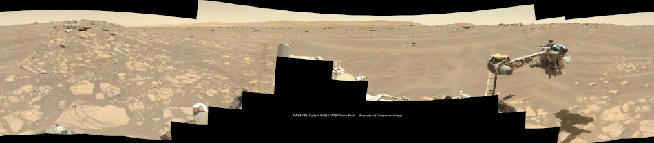
Back in the saddle again... here's the sol 237 circular panorama. We moved about 30 m east (and a bit north).
Phil
Click to view attachment
Phil
Click to view attachment
This is a "lo-fi" version of our main content. To view the full version with more information, formatting and images, please click here.