Help - Search - Members - Calendar
Full Version: Ingenuity- Mars 2020 Helicopter
Unmanned Spaceflight.com > Mars & Missions > Perseverance- Mars 2020 Rover
Pages: 1, 2, 3, 4, 5, 6, 7, 8, 9, 10, 11, 12, 13, 14, 15, 16, 17
Cherurbino
A few hours ago a new entry (revision as of 04:23, 22 March 2022) appeared in the Wikipedia article with the following coordinates of flight #22 landing:

CODE
{"longitude":{"value":77.4456182002905,"unit":"degree"},
"latitude":{"value":18.44901422293474,"unit":"degree"},
"easting":{"value":4590565.593327679,"unit":"meter"},
"northing":{"value":1093559.737667631,"unit":"meter"}}


Presumably the editor (it's anonymous without user page where I could ask him) used a source other than the commonly known JSON ("m20_heli_waypoints.json") which still ends with the "flight 21" record. Could anybody help to find another JSON query returning the current coordinates for Ingenuity? (Perseverance has multiple JSON's extracting waypoints and traverse paths).
-- Thank you, Cherurbino
Cherurbino
QUOTE (tau @ Mar 18 2022, 06:46 PM) *
Now we have distances of 720, 630, 820 and 1330 meters.

I can't beleive my eyes but rough estimates of communications' distance before Ingenuity's last departure and Perseverance at sol 384 show circa 1300 m.
Coordinates of helicopter's arrival are unknown but it's obviuos that the final distance between vehicles is even more.
vikingmars
QUOTE (Cherurbino @ Mar 22 2022, 07:01 AM) *
I can't beleive my eyes but rough estimates of communications' distance before Ingenuity's last departure and Perseverance at sol 384 show circa 1300 m.
Coordinates of helicopter's arrival are unknown but it's obviuos that the final distance between vehicles is even more.

Yes: to make Ingenuity's extended mission happen, they will have to try soon the next flights wink.gif
Cherurbino
https://twitter.com/NASAJPL/status/1506072916797972483
Over the weekend, the #MarsHelicopter took its 22nd flight!
The trip lasted 101.4 seconds and Ingenuity got up to 10 meters in the air. The team is planning another flight perhaps as early as later this week.
mcaplinger
Maybe we could just avoid all this churn and wait for the official site to be updated?
Bill Harris
QUOTE (Cherurbino @ Mar 22 2022, 10:55 AM) *
https://twitter.com/NASAJPL/status/1506072916797972483
Over the weekend, the #MarsHelicopter took its 22nd flight!
The trip lasted 101.4 seconds and Ingenuity got up to 10 meters in the air. The team is planning another flight perhaps as early as later this week.


Interesting analyses of the copter a year into it's mission flying four times the number of missions it was designed for.
This is indeed "The Little Copter that Could"!

--Bill
tau
Combined visibility analysis of the communication antennas with the helicopter at its current (sol 388) position and at the planned landing position beyond Séítah.
Light gray: Line-of-sight from both helicopter positions to the rover is blocked by terrain obstacles.
Semitransparent gray: Line-of-sight from one of both positions is blocked.
Transparent (full color): Communication from both helicopter positions to the rover is possible.
Interesting result: There is a small area (blue circle) ahead of the rover on its planned traverse,
where the rover antenna has free lines-of-sight to the launch AND landing position when the helicopter is flying the non-stop route.

Click to view attachment
Cherurbino
QUOTE (tau @ Mar 26 2022, 02:32 PM) *
Combined visibility analysis of the communication antennas with the helicopter at its current (sol 388) position and at the planned landing position beyond Séítah.

Terrific!
I wish an article on that subject, with drawings and calculations, to appear anywhere in the Internet sites (not forums sad.gif ) so I could refer to it in Wikipedia. Forums are not appreciated, alas ((.
Cherurbino
QUOTE (tau @ Mar 26 2022, 02:32 PM) *
Combined visibility analysis of the communication antennas with the helicopter

DRAFT TABLE, CALCULATIONS OF LOS ARE ERRATIC, published only as illustration for the question

Source:

Units: "easting" and "northing" in meters
Method: Pythagorean theorem
Line "flight 0" contains the coordinates of the initial deployment of helicopter
Assumptions:
1. Ingenuity’s position is taken as it is shown in JSON (upon arrival to the destination a/f)
2. Perseverance’s position is taken as it shown in JSON for the sol of flight or the closest preceding sol
3. Variables for LOS’es at the departure moment are taken from the same line. E.g.: for flight #9 we take sol 133 for helicopter and sol 131 for the rover.
4. To calculate LOS at the arrival the coordinates for helicopter are taken from the next line.

QUESTION
My calculations of LOS for departure and arrival are surely wrong because the difference between ls_dep and ls_arr does not correlate with the known flight lengths. I know I'm a dummy)) but this knowledge does not help me to find out where I was mistaken. I also attach the XLS file to ease the examination.
Thank for your kind help in advance.

--Cherurbino
tau
QUOTE (Cherurbino @ Apr 2 2022, 11:42 PM) *
. . . QUESTION
My calculations of LOS for departure and arrival are surely wrong because the difference between ls_dep and ls_arr does not correlate with the known flight lengths.
If by "LOS" you mean the distance between the rover and the helicopter (which the formulas in your table suggest), then I don't understand why the difference between the distances before and after the flight should correlate with the flight length.
For example, if the helicopter flies on a circle around the rover, the difference between the distances remains zero, but the flight length can take any value.
Generally, the only restriction for geometric reasons is that the flight length cannot be shorter than the difference in distances.

QUOTE
3. Variables for LOS’es at the departure moment are taken from the same line. E.g.: for flight #9 we take sol 133 for helicopter and sol 131 for the rover.
4. To calculate LOS at the arrival the coordinates for helicopter are taken from the next line.
Obviously, the official sol numbers are assigned to the arrival positions. Therefore, in this case, the helicopter took off from position 120, so the helicopter's departure coordinates should be taken from the previous (sol 120) row in the table and the arrival coordinates from the current (sol 133) row.
For sols where both the rover and the helicopter have moved, the question remains as to which moved first. If the helicopter moved first, then the rover was possibly still at its previous position and not at the position with the same sol number as the flight ( but I'm not sure about that) .
Keltos
Flight 24 happened sol 398 smile.gif

(Sol 398 of the Perseverance rover mission) at the local mean solar time of 09:33:47.


images are on the server

Phil Stooke
Yes - it was a very short flight, maybe 30 m to the west. Not over the Skycrane.

Phil
Phil Stooke
I underestimated the distance, it was about 47 m, still quite short.

Phil
tau
An interesting status report "Balancing Risks in the 'Séítah' Region - Flight 24" is online.
Various flight limitations are discussed in the report, and it was decided that the next flight will be a long one.

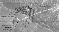
Here comes my updated mutual visibility map for the radio antennas as seen from the helicopter's current (sol 398) and planned positions.
The short flight on sol 398 has a beneficial side-effect. It opened a window (blue circle) of unobstructed radio link
from the helicopter's current position AND the planned landing position to the planned rover traverse .

Click to view attachment
PaulH51
5 NavCam frames from flight #25 (Sol 403) animated GIF.

Click to view attachment
Cherurbino
QUOTE (tau @ Apr 3 2022, 06:38 PM) *
If by "LOS" you mean the distance between the rover and the helicopter (which the formulas in your table suggest), then I don't understand why the difference between the distances before and after the flight should correlate with the flight length.


Having re-read what was written, I understood that an important explanation has been skipped, and my English was worse than ever before.

Let's stop this subject... things around me are not favourable to continue with my 'scientific' investigations as I was doing in the peaceful past.

However. Does anybody remember that today is THE FIRST ANNIVERSARY OF THE FIRST FLIGHT?

Warm congratulations to everybody!

-- Cherurbino.
Cherurbino
A question is raised in Wikipedia concerning the 26th flight.
Calculations with metric coordinates from the current JSON return the 186.67 meters between airfields Q and R.
Meanwhile the flight log shows 360 m length. Were there any intermediate points enroute which could duplicate the total distance?
-- Cherurbino.
PaulH51
QUOTE (Cherurbino @ Apr 24 2022, 10:33 PM) *
A question is raised concerning the 26th flight.
Calculations with metric coordinates from the current JSON return the 186.67 meters between airfields Q and R.
Meanwhile the flight log shows 360 m length. Were there any intermediate points enroute which could duplicate the total distance?
-- Cherurbino.

The intermediate waypoints will eventually be published in the helicopter flight path JSON link. The flight was to include imaging of the EDL hardware (backshell and parachute) and that they would not fly directly over any wreckage, so we can only speculate on a path, maybe to the south, then west, before returning north to heli site 26.
Phil Stooke
This tweet:

https://twitter.com/65dbNoise/status/1517597402076745728

shows a speculative trajectory for flight 26. The source is usually pretty good with these things.

Phil
PaulH51
Flight 27 is in the books and the mystery of the flight path for flight 26 is solved with the update of the mission map. LINK
Tom Tamlyn
That's an impressively crooked flight path.

The reason for the first zig and zag seems obvious: to avoid a patch of rough terrain.

But does anyone know (or have a guess for) the reason for the very sharp zig towards the end of the path?
vikingmars
QUOTE (Tom Tamlyn @ Apr 26 2022, 04:28 AM) *
That's an impressively crooked flight path.
The reason for the first zig and zag seems obvious: to avoid a patch of rough terrain.
But does anyone know (or have a guess for) the reason for the very sharp zig towards the end of the path?

Yes : this path was designed to take some images of the parachute and its backshell smile.gif
http://www.unmannedspaceflight.com/index.p...st&p=256908
neo56
And here are the pictures of the parachute and the backshell ohmy.gif

Click to view attachment

Click to view attachment

Source: Allan Chen on Twitter
Nahúm
The aeroshell and parachute image has been downlinked and avaiable on the web: https://mars.nasa.gov/mars2020-raw-images/p...0_000085J01.png
john_s
Cropped and stretched version:

Click to view attachment
Explorer1
That calls for another avatar change...
tau
Yet another processed version of the parachute and backshell photo. The parachute ropes are faintly visible.

Click to view attachment
neo56
First RTE picture of sol 414 corrected for distorsion, vignetting and colors. Contrast increased on zoomed version.


neo56
The next 7 pictures taken on sol 414 by RTE camera, corrected for distorsion, vignetting and colors.
Olivier, I guess you'll be happy with these pictures you expected!


tau
It looks quite ... extraterrestrial!

Click to view attachment
neo56
A cropped version of one of these amazing pictures. "Job done, the rover is on Mars, we can crash!"
James Sorenson
My take smile.gif

Credit: NASA/JPL-Caltech/James Sorenson


And Last but not leased, the GIF!

MahFL
Well, so much for not "flying near wreckage"...
xflare
Any ideas what speed the backshell would have been falling at when it impacted the ground? Would the parachute still be fully deployed at that time?

edit: The press release says 78mph / 126kph.
nprev
Per this Spaceflight Now article, estimated impact velocity was 126 km/hr (78 mph)
fredk
From neo's adjusted versions, here's a brazen attempt at a stereo view. The displacements are far too large for good stereo, so be warned: these are eye-ache-inducing! blink.gif Still, this does help reveal how the backshell was damaged on impact.

Cross-eyed:
Click to view attachment
Anaglyph:
Click to view attachment
Explorer1
QUOTE (tau @ Apr 27 2022, 03:38 PM) *
It looks quite ... extraterrestrial!


Indeed, those rocks never knew what hit them! It's quite interesting to compare with the images of Zhurong's backshell last year, which seems pretty much whole from the (slightly poorer views).

An impact few meters in the other direction and the soft sand might have caused slightly less damage....
vikingmars
QUOTE (neo56 @ Apr 27 2022, 10:31 PM) *
The next 7 pictures taken on sol 414 by RTE camera, corrected for distorsion, vignetting and colors.
Olivier, I guess you'll be happy with these pictures you expected!

Thank you so much Neo56 (and to James Sorenson) for those stunning processings of yours!
Yes, I'm very glad to see these images and I must congratulate the Ingenuity Team for having provided us with this stunning flight and results.
And we can thank their members also for having responded so kindly to the wishes of the space amateur community smile.gif
And also congratulations to the JPL engineers for having done such a great design for the backshell and its parachute which performed so well wheel.gif
climber
QUOTE (xflare @ Apr 28 2022, 12:11 AM) *
Any ideas what speed the backshell would have been falling at when it impacted the ground? Would the parachute still be fully deployed at that time?

edit: The press release says 78mph / 126kph.

I can’t imagine the parachute been fully open at impact and still get such damages. I suppose JPL did simulations of this part of the EDL hardware after been discarded before the skycrane. We sew visually that the parachute was fully open in due time. What came next is a bit surprising to me and I guess 126 kph is a… guess. BTW, do we have MRO images showing this hardware falling down while Perseverance was also doing the Skycrane manœuvre ?
Cherurbino
I regret to inform that the flle naming convention is broken again, now for two RTE's
  • HSF_0418_0703689905_000ECM_N0270001HELI00000_000085J Sol 414 11:38:45
  • HSF_0418_0703689914_000ECM_N0270001HELI00001_000085J Sol 414 11:38:54

This causes the bug at services like https://rkinnett.github.io/roverpics/?ingenuity where the 4-digit sol group (zero-based offset 4 to 7) is used to sort the output sy sols. Thus, the query for sol 414 returns only 7 files, while other 2 files are misplaced being moved to the set for flight 27.

Finally, 7 + 2 = 9 while NASA says of "10 aerial color images taken April 19 during Ingenuity’s Flight 26."
Where is image #10, and how much images are in this file? I see three, but in this case the total image count exceeds ten [7 + (1 + 3)]


I cherish a dream that somebody shall draw the map of flight #26 with the 'brackets' for each of the RTE images' sequence', like it was done last September.


Thank you,
- Cherurbino
stevesliva
QUOTE (climber @ Apr 28 2022, 03:34 AM) *
I can’t imagine the parachute been fully open at impact and still get such damages.


It was not for landing, so there's no reason to conclude it being fully open corresponds with "gentle descent." That's what the skycrane was for...
Bill Harris
The parachute was designed to make a controlled descent for the Skycrane to make a perfect landing. Certainly that is substantial damage to the Backshell. One might expect that once the Skycrane+Rover departed from the Parachute+Backshell that the weight would be greatly reduced and the Chute, et al, would drift lazily away. I imagine that the designers expected that too, and feared that the Chute would interfere with the Landing, and collapsed the Chute so it would impact away from the Landing area.
Or so it would seem

--Bill
Bill Harris
QUOTE (tau @ Apr 27 2022, 03:38 PM) *
It looks quite ... extraterrestrial!

Click to view attachment

I looks like a Bellyflop!
Bill Harris
QUOTE (tau @ Apr 27 2022, 12:41 PM) *
Yet another processed version of the parachute and backshell photo. The parachute ropes are faintly visible.

Click to view attachment

And look at the "gash" on the right side of the Chute. This Chute was intentionally disabled.
john_s
If you mean that rectangular gap, it was present all along, as seen in descent images-

Click to view attachment

John
djellison
QUOTE (Bill Harris @ Apr 28 2022, 08:51 AM) *
One might expect that once the Skycrane+Rover departed from the Parachute+Backshell that the weight would be greatly reduced and the Chute, et al, would drift lazily away. I imagine that the designers expected that too, and feared that the Chute would interfere with the Landing, and collapsed the Chute so it would impact away from the Landing area.
Or so it would seem

.....


And look at the "gash" on the right side of the Chute. This Chute was intentionally disabled.


No. That 'gash' is part of the disk-gap-band design of the parachute.

https://mars.nasa.gov/resources/24989/wind-...nces-parachute/

Drag scales with the square of the velocity - so even when the powered descent vehicle drops out of the backshell and the mass is dropped to ~20% of what it was....the speed only reduces by a little over half to something like ~80mph ( the JPL release says about 78 )

Without the heatshield in place - the bottom of the backshell crashing into the ground at fast freeways speeds is frankly the absolute worst case for structural integrity of the backshell - it's little surprise it has broken up as much as it has.

Collapsing the chute would be a bad idea - that would have accelerated the backshell and increased the likelihood of a recontact issue with the powered descent vehicle. No EDL has done this. You want the backshell and parachute to take their time to drift in the breeze and end up far, far away. The divert maneuver as part of the powered descent phase is also to help reduce the recontact problem.

Everything in the Ingenuity images is consistent with the backshell and 'chute landing normally - at an expected terminal velocity with an intact and fully inflated chute.
neo56
The 10 RTE pictures of Flight 27 arrived. We still see the backshell and parachute as Ingenuity leaves the area.

GIF animation:
Click to view attachment

And the pictures:


PaulH51
Ingenuity just made its 28th flight during sol 423.
Animated GIF from the 5 available Heli NavCams
Click to view attachment
serpens
QUOTE (djellison @ Apr 28 2022, 05:37 PM) *
....Drag scales with the square of the velocity - so even when the powered descent vehicle drops out of the backshell and the mass is dropped to ~20% of what it was....the speed only reduces by a little over half to something like ~80mph ( the JPL release says about 78 )....


I would have thought that following the Mars Climate Orbiter failure the Imperial system would be verboten for any purpose within NASA and only the metric used, or is this a conversion for public consumption.
This is a "lo-fi" version of our main content. To view the full version with more information, formatting and images, please click here.
Invision Power Board © 2001-2024 Invision Power Services, Inc.