Percy is down!!! Congratulations to the team!!!!
We'll talk about it here. What a great day!!!
Full Version: Perseverance Lands In Jezero Crater
It never gets old and boring.
Phil
Phil
My gosh, this is absolutely amazing. Congratulations to the team!

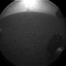
First image
Congratulations Perseverance team and - Horray!!
At first glance the landing site looks a bit less rocky to me than most of the earlier landing sites did.
Congratulations to the Perseverance team!
Congratulations to the Perseverance team!
On the JPL feed there is a map that has been in view a few times. If the green dot is the estimated landing site it looks pretty dead center of the landing ellipse.
That is how you land on Mars. Excellent.
"At first glance the landing site looks a bit less rocky to me than most of the earlier landing sites did."
Except for the Viking and Pathfinder sites.
Phil
Except for the Viking and Pathfinder sites.
Phil
And here's the RHAZ view:
Click to view attachment
Click to view attachment
Looks like it landed amidst a small cluster of rocks in a field of sand (hopefully not spirit killer quicksand).
Fantastic, and not as rocky as the Viking or Pathfinder sites. A few blocks with angualr edges upright, and maybe some low sand drifts further back. The excitment of landing on another planet never pales...
Congrats to all members of all the Perseverance Teams!
We're breathing again
We're breathing again
An educated guess at landing location https://twitter.com/jccwrt/status/1362509961700536323?s=20
Congrats to the team!
JPL: world and outta-this-world champions at landing on other planets.
JPL: world and outta-this-world champions at landing on other planets.
Congrats to all involved. EDL went so fast I hardly had time to breathe.
Any idea of the rover's current orientation?
P
Any idea of the rover's current orientation?
P
QUOTE (fredk @ Feb 18 2021, 10:10 PM) 
And here's the RHAZ view:
Click to view attachment
Click to view attachment
Interesting terrain....
Much different then the curiosity bedrock.
Does one of the hazcam images show the impact/explosion of the upper stage, as they did with Curiosity?
They are getting good data from the Rover, including its orientation in 3 dimensions. Not yet anything from the descent imager.
Will be interesting to learn about hazard avoidance during EDL, given that the landing ellipse includes some of the delta. Good view of the hazard maps in post #17.
We seem to be pointing very roughly towards the SE according to the hazcams. The FHAZ view seems to show some of the SE rim or the hill just outside the SE rim (arrowed):
Click to view attachment
Click to view attachment
QUOTE
Does one of the hazcam images show the impact/explosion of the upper stage, as they did with Curiosity?
Once we get all the Sol 0 imagery down, we'll be in a better position to evaluate what's in it.
And the RHAZ view shows what might be some of the west rim (arrowed):
Click to view attachment
There's probably crud on the lens cover, though they don't look all that bad.
And congratulations to the team!
Click to view attachment
There's probably crud on the lens cover, though they don't look all that bad.
And congratulations to the team!
QUOTE ("Hungry4info")
Once we get all the Sol 0 imagery down, we'll be in a better position to evaluate what's in it.
That being said, this does look a lot like a crash plume.
QUOTE (Hungry4info @ Feb 18 2021, 03:37 PM)
That being said, this does look a lot like a crash plume.
Or just dust from the landing itself.
Yeah, that would be way too close for a crash plume.
QUOTE
Yeah, that would be way too close for a crash plume.
I'm not sure how you managed to determine it's distance. But it does look very similar to the MSL descent stage crash plume (attached).
A reminder of what MSL's plume looked like:
This new one does look similar and is also in the rear hazcam.
Edit: scooped by Hungry!
This new one does look similar and is also in the rear hazcam.
Edit: scooped by Hungry!
"Interesting terrain....
Much different then the curiosity bedrock. "
Different from the current rock around Curiosity, but this is quite similar to the actual Curiosity landing site (at least in these very early hazcams)
Phil
Much different then the curiosity bedrock. "
Different from the current rock around Curiosity, but this is quite similar to the actual Curiosity landing site (at least in these very early hazcams)
Phil
The plume crash plume in the MSL photo is on/over the horizon. The apparent dust cloud in the Perseverance image appears closer than the horizon.
Yes, with the dust-cloud well below the horizon on such a wide-angle view it must be very close.
Remember the first Oppy hazcam shots. We thought they showed a huge outcrop. Turns out it was just a few centimeters high.
Remember the first Oppy hazcam shots. We thought they showed a huge outcrop. Turns out it was just a few centimeters high.
Using the images from MERovingian's link and increasing the contrast, it is clear that the feature is at/over the local horizon.
Such a great start! the new landing system spoiled us with what seems to be perfect placement, so the interactive ESA Jezero map may not even need to relocate their 'Perseverance landing site' pin.. to get the probable skycrane crash plume in just the second downlinked image is more icing on the cake and hopefully there will be more frames to help determine how quickly the plume settles, and not to mention congrats to JPL on returning that meteorite fragment to its original home!
This one looks better
Click to view attachment
Click to view attachment
Only one partial that is not a thumbnail. Cropped, curves adjusted and enlarged 200%
Post landing conference scheduled at 22h30 UTC in another 15 minutes or so
I guess there will always be an essential similarity to the immediate vicinity of safe landing sites... 
The landing site is likely the white dot. I suspect the "top" horizon in the Rear HazCam images is probably the cliff that defines the delta.
Super achievement...congrats to you Mars's guys and team (would love to be involved in its future exploration).
John
John
This would be in Canyon de Chelly square
Click to view attachment
Click to view attachment
I'd rather not if you don't mind. Mapping from beyond the grave is not on my bucket list.
EDIT: Darn.. the post I was joking about has been changed!
.
Phil
EDIT: Darn.. the post I was joking about has been changed!
.
Phil
QUOTE (Hungry4info @ Feb 18 2021, 04:27 PM)
The landing site is likely the white dot. I suspect the "top" horizon in the Rear HazCam images is probably the cliff that defines the delta.
That's my estimate from a hazard map I saw on NASA's livestream. My sources on the mission team have told me that I'm probably within 100 m of the actual landing site (about the width of the dot in all directions), but they're still in the process of refining the position from thumbnails and HiRISE DTMs, probably won't know for sure until data comes down from an MRO pass this evening.
Looks like a good early traverse ahead! We're on the edge of the mafic floor unit, the etched floor unit is only a few days' drive away (probably doable within a day if the Ops team really wanted to move that quickly), and a relatively big crater where the rover can look deep into the crater floor materials with only a short detour.
My take on the non-thumbnail-partial image...
Click to view attachment
Click to view attachment
QUOTE (Hungry4info @ Feb 18 2021, 04:03 PM)
Using the images from MERovingian's link and increasing the contrast, it is clear that the feature is at/over the local horizon.
Hm, I think you're right. Initially thought that hill was the local horizon.
Ok, I guess I have to cool down a bit...
Edit after Phil's edit : wondering if I misunderstood your post but I have to cool down a bit anyway
Edit after Phil's edit : wondering if I misunderstood your post but I have to cool down a bit anyway
Partial image combined with thumb, plus a little contrast and sharpening
Click to view attachment
Click to view attachment
Hopefully, they'll have a peek at the backshell. Curiosity didn't even get a photo op of its landing hardware.
It is somehow reassuring to again have two rovers operating on Mars.
This is a "lo-fi" version of our main content. To view the full version with more information, formatting and images, please click here.