Help - Search - Members - Calendar
Full Version: Perseverance Lands In Jezero Crater
Unmanned Spaceflight.com > Mars & Missions > Perseverance- Mars 2020 Rover
Pages: 1, 2, 3, 4, 5, 6, 7, 8, 9, 10
Pando
QUOTE (Shan @ Feb 24 2021, 07:27 PM) *
Whether the Rover descent cam captured the backshell before it landed?


No, it didn't. Your arrow is not pointing at a correct place. I've circled the back shell landing spot (it's clearly not there), and the parachute location is further off-screen.
rlorenz
QUOTE (scalbers @ Feb 24 2021, 07:02 PM) *
Are these rocks being polished somehow and then giving a specular reflection of the sun, that is about at that azimuth?


See the 1974 movie Phase IV. Maybe Perseverance has found intelligent ants

Pando
QUOTE (Ares57 @ Feb 24 2021, 06:30 PM) *
I will use Pando’s labelling and call the left hand group of rocks in the Mastcam image containing the shiny rock Group1 and the right hand group Group2. To my eyes fredk’s anaglyph image clearly shows Group1 to be further away than Group2 (I would say quite some distance). However Pando’s map shows Group1 to be closer to the rover than Group2. If I have interpreted fredk’s post #337 correctly, he has the black arrow pointing to Group1 and the white arrow to Group2. If so, then they are much the same distance from the rover and this again conflicts with my depth perception of the anaglyph image.

The key question seems to be what are the relative distances from the rover of Group1 and Group2. Are my eyes misinterpreting the image? Also relevant would be how much the closer terrain is likely to hide the two small hills. If they are invisible then my following suggestion is obviously wrong.


Groups 1 and 2 are about 25 meters apart. You can see that 1 is slightly in front of 2 with this flicker gif:


And I've also included a slightly slanted view of the two rock piles viewed from the direction of the rover (bottom).
djellison
QUOTE (spacepoint @ Feb 24 2021, 01:18 PM) *
IMHO, orientation of rover is correct to think that is actually back shell, flipped. blink.gif


No - it isn't. The shiny rock is left of the distant mesa. The parachute and backshell are to the right of the distant mesa.
Pando
QUOTE (Ares57 @ Feb 24 2021, 06:30 PM) *
If my perception of the relative distances are correct, then I agree with walfy and think the shiny rock is on the eastern end of the eastern (closer) small hill with a vague suggestion of correspondence of elements as follows:

Click to view attachment


You are actually correct to point out the "Cliff" in your image. This is the distant hill that you can barely see directly behind the shiny rock, 2km away. The two rock piles are much closer however, 492m from the rover, on a ridge which slopes down behind the rocks. You can see it best on the flicker gif above.
vikingmars
QUOTE (eliBonora @ Feb 23 2021, 07:35 PM) *
Hello everybody,
I'm joining this group again with Perseverance smile.gif 
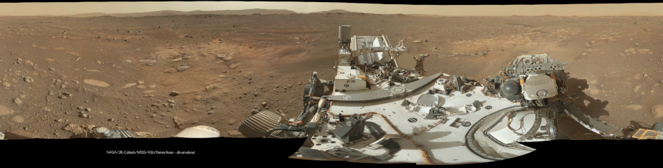
to share our first NavCam (selfie style!) sol 2

How nice ! wheel.gif wheel.gif wheel.gif wheel.gif wheel.gif wheel.gif
Thank you so much eliBonora for sharing this very nice (and impressive) work of yours smile.gif
Andreas Plesch
QUOTE (kymani76 @ Feb 19 2021, 04:31 AM) *
Now we know where more exactly where Perseverance landed, it is time for new maps. I just hope Phil will create mapping thread soon.
I'm using coordinates from JPL's interactive Mars2020 map (reading long: 77,450811, lat: 18,44675 from the map).
...

I registered the MRO image of the landed rover with the 25cm resolution HiRISE mosaic which is well georeferenced, and obtained coordinates for the rover this way. The result is very close to position to the marker on JPL's interactive map but about 5m farther to the SE. I believe the registration should be accurate to 1m. The coordinates for the rover on the post-landing MRO image I get are:

77.4508882°E, 18.4446394°N , CRS: EPSG 104971 - Mars 2000 (Sphere)

There was a comment by EDL lead at a panel that they landed within 5m of the spot the system had targeted. So perhaps the marker on the interactive map is the targeted location but the actual, exact location is a bit away from that ?

Click to view attachment

The MRO image has been tinted red and is contrast enhanced. I can provide the registered GeoTIFF if there is interest.

Here is a link to slides for comparing the registration with the mosaic:
http://bit.ly/PercyCOORDs

The mosaic is contrast enhanced for the shown extent.

Sources:
https://planetarymaps.usgs.gov/mosaic/mars2...n0_first_dd.tif (> 9GB !)
https://mars.nasa.gov/system/downloadable_i...No-Contrast.jpg
walfy
For what it's worth, another attempt at locating the shiny rock out there! Pando's suggestion seemed good, but I don't see from the mastcam the vast stretch of sand dunes between the hillocks he pointed out and the rover. The shiny rock might be much closer. I tried to line up some HIRISE features with the mastcam image again, though not certain I'm just seeing what I want to see.

Click to view attachment
phase4
QUOTE (rlorenz @ Feb 25 2021, 05:12 AM) *
See the 1974 movie Phase IV. Maybe Perseverance has found intelligent ants

I concur laugh.gif
Pando
QUOTE (walfy @ Feb 25 2021, 01:46 AM) *
...but I don't see from the mastcam the vast stretch of sand dunes between the hillocks he pointed out and the rover.


It's because of terrain. There is a ridge close to the rover (the geological contact, the curved line visible from overhead). Most of the dunes are behind that ridge and not visible.

The shiny rock is on top of a second ridge. It's pretty tall as it casts a shadow.
alan
Debris stacked on top of debris.

The next rover should be a bulldozer.
kenny
NASA TV tour of the mastcam image at 4pm EST = 9pm GMT /UTC.

NASA TV schedule
kenny
From the briefing, the first informal name I noticed... The Harbour Seal !

Click to view attachment
MahFL
Is the software switch over currently happening to the surface ops s/w ? It's Sol7 and no images are on the raw site since Sol4.
Marvin
QUOTE (MahFL @ Feb 25 2021, 09:10 PM) *
Is the software switch over currently happening to the surface ops s/w ? It's Sol7 and no images are on the raw site since Sol4.


At the briefing today, they said they are switching the software to surface ops now, and could take days. But they didn't say when they started.
djellison
QUOTE (MahFL @ Feb 25 2021, 05:10 PM) *
Is the software switch over currently happening to the surface ops s/w ?


Yes. Things should get back to normal at the weekend.
MahFL
Indeed @SpaceGirlKim says they are on Sol4 of the 4 needed Sols.
mcaplinger
QUOTE (MahFL @ Feb 25 2021, 08:47 PM) *
Indeed @SpaceGirlKim says they are on Sol4 of the 4 needed Sols.

Well, she says sol 8 is the last sol, and it's sol 7 19:19 right now, so no new imaging until sol 9, and then probably no data until sol 10.
marswiggle
About the bright speck, my idea generally reflects walfy's latest identification, which is excellently accurately indicated.

I just thought it might be worth zooming a bit out again for a wider context, so here’s the anaglyph of the 'original' navcam observation, cropped and exaggerated to highlight the topography.
Note the rocket exhaust plume marks at the foreground and a couple of ripples on the short way to the ridge. The ridge (on the geological unit border) extends to the right of the speck as a long dune crest at an even distance, and as this is known to be ~100 m away, the bright spot can’t be much farther either. While there indeed seems to be two separate ridges around the speck, I would guess they are just the shallow rims of a small crater-like depression, also visible in walfy's image.
Andreas Plesch
To gain a better understanding and feel for the regional context, I made a 20m point cloud model using the ctx (context) DEM. It came out pretty well and somewhat dramatic after vertically exaggerating the relief 3x. I also added the rover model at the landing site, 100x enlarged. I may put the model on an interactive web page but it is not really useful yet. Let me share a few screenshots:

Click to view attachment

Ant103
Sol 3 MastcamZ full panoramic. It was time consuming to get all the picture right, and the overall pan to have a good rendering but it's done smile.gif

vikingmars
QUOTE (Ant103 @ Feb 26 2021, 01:31 PM) *
Sol 3 MastcamZ full panoramic. It was time consuming to get all the picture right, and the overall pan to have a good rendering but it's done smile.gif

Thanks a lot Damia for this outstanding work of yours smile.gif Your a great master of Mars imaging !
(I did the same pan last night and it took me 6 hours to process the pics, with devignetting, color balance, etc., etc....).
Also congratulations for you very nice website wheel.gif wheel.gif wheel.gif wheel.gif wheel.gif wheel.gif
JRehling
That's a great 3D image, Andreas. The site is a bit disorienting in that the delta is itself quite imposing vertically but the crater rim is considerably more so.

This mission has quite a different feel from Curiosity, despite certain similarities. Curiosity found many of its most important results at the bottom of an upward traverse. Perseverance is, I think, going to have to work for it more before we get to the real standout discoveries. But, who knows…
Andreas Plesch
Channeling a far future helicopter ride, I recorded 4 and 5 minutes, rough animations of flying through my point cloud model (see above) along the crater rim and delta (3x v.e.):


http://bit.ly/PercyFlight5min
http://bit.ly/PercyFlight4min

Feel free to play at double speed. 1080HD resolution recommended but still blurry.

Just having fun smile.gif


Andreas Plesch
QUOTE (JRehling @ Feb 26 2021, 11:32 AM) *
That's a great 3D image, Andreas. The site is a bit disorienting in that the delta is itself quite imposing vertically but the crater rim is considerably more so.

This mission has quite a different feel from Curiosity, despite certain similarities. Curiosity found many of its most important results at the bottom of an upward traverse. Perseverance is, I think, going to have to work for it more before we get to the real standout discoveries. But, who knows…


Thanks ! I probably should make images with less vertical exaggeration but viewed from high altitude the added relief, I think, does help convey a better qualitative sense of the topography. I think it has to do with how at ground level a 30 degree slope would appear very steep and hard to climb while "in reality" it is far from vertical. There is a perception of relief based on our personal experience of moving around.

Getting to the beach terraces and climbing up the front of the delta, I think, would be my favorite (first) targets to look forward to, in a few months (?)
fredk
QUOTE (Ant103 @ Feb 26 2021, 01:31 PM) *
Sol 3 MastcamZ full panoramic.

Absolutely stunning!

Looking at an MCZ frame such as this one:
https://mars.nasa.gov/mars2020-raw-images/p...6_034085J01.png
It looks like the focus is close to the near foreground at the bottom of the frame and the rocks on the mid-horizon are somewhat soft. However, in the "crater rim" crop of the full 360 pan, released here, those same rocks are in much better focus.

Doing a software sharpening of the individual frame I can't recover anywhere near the detail in the "crater rim" crop. Can anyone else? Or was the crop from different frames?
Nix
Wasn't the panorama shot in the 'normal' mode (no zoom)?
neo56
My take on the Mastcam-Z (left) sol 3 panorama.

mcaplinger
QUOTE (fredk @ Feb 26 2021, 01:06 PM) *
Or was the crop from different frames?

Probably from the tier below in the overlap region?

Not all of the images in the 360 pan are as well-focused as they possibly could be, we're still working on that.
fredk
Here's the image from the tier below:
https://mars.nasa.gov/mars2020-raw-images/p...6_034085J01.png
It is better focused, but doesn't extend as high as that mid horizon in the frame above it. Perhaps there are simply more frames still to arrive from that sol on the public "raw" site.
atomoid
On the rover there is an apparent fabric material used as a sort of backplate for the RTG assembly, which can be seen wildly flapping around during the skycrane maneuver at about 2:52 in the NASA video and there's a mastcam closeup in this image.Curiosity appears to have the same item but I didnt find anything online in regards to what purpose this element serves, it seems to be composed of the same material apparently used to shield separated areas of the rover from incursions of sand and kicked up material such as can be seen in this image.
mcaplinger
QUOTE (atomoid @ Feb 27 2021, 01:14 PM) *
On the rover there is an apparent fabric material...

Beta cloth. https://bronaerotech.com/product/ba-500bc-cf500f-beta-cloth/
Marvin
QUOTE (atomoid @ Feb 27 2021, 05:14 PM) *
On the rover there is an apparent fabric material used as a sort of backplate for the RTG assembly,


It's a windbreaker, which reduces heat loss from the wind:

Click to view attachment

Source: https://trs.jpl.nasa.gov/handle/2014/44910

RTGs are an amazing technology, first used in military satellites in the 1960s and more famously on the Apollo moon missions as part of the ALSEP surface experiments package.
HSchirmer
QUOTE (Marvin @ Feb 27 2021, 11:17 PM) *
RTGs are an amazing technology, first used in military satellites in the 1960s and more famously on the Apollo moon missions as part of the surface experiments package.

Would STILL love to find a way to use the RTG to get generate alpha or gamma spectroscopy on samples.
MahFL
New images came down.
MahFL
It's a rock after all...
HSchirmer
QUOTE (MahFL)
It's a rock after all...
Eh, it's a large flat shiny white rock, on top of a column of sediment, in a mostly dark, mafic, basaltic volcanic deposit. That actually makes it MORE interesting that if it was the backshell.
xflare
It looks very similar to Gusev Crater.

Although clear layering visible in parts of the delta

https://mars.nasa.gov/mars2020-raw-images/p...6_110085J01.png

And WOW!!

https://mars.nasa.gov/mars2020-raw-images/p...6_110085J01.png
djellison
This is the best I could do with the Sol 3 Mastcam Z images of the foreground.

https://sketchfab.com/3d-models/m2020-landi...7c685f31cf97c30

Click to view attachment
djellison
QUOTE (HSchirmer @ Feb 27 2021, 03:36 PM) *
Eh, it's a large flat shiny white rock,


Looks the same as all the other rocks around to be honest - it just happens to be in the direction of the sun at 2-4pm in the afternoon and so is getting some glinting going on when it's photographed.

Take the images about 5 hours earlier and I'd bet we be remarking just how 'shiny' this pile of rocks is
https://mars.nasa.gov/mars2020-raw-images/p...6_110085J01.png
scalbers
QUOTE (djellison @ Feb 28 2021, 12:30 AM) *
This is the best I could do with the Sol 3 Mastcam Z images of the foreground.

https://sketchfab.com/3d-models/m2020-landi...7c685f31cf97c30

Click to view attachment


Looks nicely detailed - thanks for posting your latest, Doug. I was able to view this with the "First Person" navigation setting. Next I'm checking to see if it is possible to "walk" at constant eye/camera height. I'm unable to do this so far, though I understand SketchUp (a related package) should allow it.
tdemko
Click to view attachment

QUOTE (xflare @ Feb 27 2021, 07:12 PM) *


Here is my five minute stratal architecture. Looks like two packages of deltaic clinothems. The lower shows a classic thickening-upwards (I drew a schematic grain size curve on the right), indicating progradation of the depositional system. It also has some large-scale deformation, which is not unusual in deltaic settings because of gravitational failure along the steep slopes and episodic rapid sedimentation. Truncation of the contorted strata could have been formed by sub aerial erosion during a lake-level fall, or by wave-ravinement during the subsequent lake-level rise.

The two clinothems also show a progradational stacking pattern, with the upper distinctively in front of the lower. This could also be reflecting en echelon stacking of the deltaic lobes, with the thick sandy proximal parts preferentially filling the in the accommodation above the thinner, finer-grained parts of the older lobes.

The outcrop indicates that the lake level fluctuated, and delta lobes were able to prograde back out after lake level rise. The deformation indicates rapid deposition. There may also be a sediment-gravity flow system of subaqueous fans and channels outboard of the stacked delta lobes.

There are many terrestrial outcrops of ancient lacustrine deltas that show these same features and relationships. The Eocene Green River Formation of Wyoming and Utah comes to mind as good analogs.
djellison
QUOTE (scalbers @ Feb 27 2021, 05:31 PM) *
I was able to view this with the "First Person" navigation setting. Next I'm checking to see if it is possible to "walk" at constant eye/camera height.


Using the AR/VR option is should be possible - you might need to install the Sketchfab app to do it though.
rlorenz
QUOTE (HSchirmer @ Feb 27 2021, 06:12 PM) *
Would STILL love to find a way to use the RTG to get generate alpha or gamma spectroscopy on samples.


We looked into that for Dragonfly. An MMRTG isnt a great source for that.

The MMRTG neutron flux excites some gammas in the ground, but most of the neutrons are 1-2 MeV, so you don't excite many of the gamma emissions you'd want, plus there is also a gamma background from the MMRTG itself. So for decent gamma ray spectroscopy Dragonfly has a pulsed neutron generator (which generates 12 MeV neutrons from D-T fusion : I like to say the PNG is a neutron gun, a particle accelerator, and a fusion reactor !)

What the MMRTG does let you do is neutron spectroscopy - you can get a useful hydrogen abundance measurement by measuring the thermal and epithermal neutrons backscattered by the ground. The DAN instrument on Curiosity did active neutron measurements (with a PNG), but also passive ones excited by cosmic rays and the MMRTG, of which the latter provided about half the signal.

On Titan the thicker atmosphere screens out almost all the cosmic rays, but the MMRTG neutron flux on the surface will let us get a passive measurement (as well as an active one using the PNG)

I dont believe you get many alphas outside the MMRTG housing.
rlorenz
QUOTE (Marvin @ Feb 27 2021, 05:17 PM) *
RTGs are an amazing technology.


My last business trip before the pandemic stopped me traveling was to make measurements on the Perseverance MMRTG at the Idaho National Labs. That's me ('1st author') in the khaki shirt at left
Click to view attachment
- when I was making atmospheric ionization measurements I was close enough to feel its warmth on my cheek.
Click to view attachment
Amazing to see that same piece of hardware on Mars now..
Toma B
3 Mars Perseverance Sol 4 Mastcam-Z Panoramas.

Sol 4 Mars2020 Panorama1 by Tomislav Bandin, on Flickr

Sol 4 Mars2020 Panorama2 by Tomislav Bandin, on Flickr

Sol 4 Mars2020 Panorama3 by Tomislav Bandin, on Flickr
eliBonora
This is our 360 version of sol 3 Mastcam-z (it's not full size):

charborob
Sol 4 Mastcam-Z anaglyph of an interesting rock:
Click to view attachment
HSchirmer
QUOTE (charborob @ Feb 28 2021, 05:20 PM) *
Sol 4 Mastcam-Z anaglyph of an interesting rock:

I'm amazed at the sheer number of "mission killer" rocks around, and at the navigation capability that set Percy down safely...
Pando
QUOTE (rlorenz @ Feb 27 2021, 07:30 PM) *
My last business trip before the pandemic stopped me traveling was to make measurements on the Perseverance MMRTG at the Idaho National Labs. That's me ('1st author') in the khaki shirt at left
Click to view attachment
- when I was making atmospheric ionization measurements I was close enough to feel its warmth on my cheek.
Click to view attachment
Amazing to see that same piece of hardware on Mars now..


And to think that it costs more than $100 million to just manufacture that thing. blink.gif
This is a "lo-fi" version of our main content. To view the full version with more information, formatting and images, please click here.
Invision Power Board © 2001-2024 Invision Power Services, Inc.