Marvin
Feb 28 2021, 08:12 PM
QUOTE (Pando @ Feb 28 2021, 03:40 PM)

And to think that it costs more than $100 million to just manufacture that thing.

Solar panels are cheaper. But with a MMRTG, you don't have to worry about sand build up or the low solar energy days of a Martian winter. It also has an operational life of 14 years. A pretty neat piece of kit imo.
Thanks for sharing the images rlorenz.
MarkL
Feb 28 2021, 09:36 PM
QUOTE (tdemko @ Feb 28 2021, 04:02 AM)
Click to view attachmentHere is my five minute stratal architecture. Looks like two packages of deltaic clinothems. The lower shows a classic thickening-upwards I drew a (schematic grain size curve on the right), indicating progradation of the depositional system. It also has some large-scale deformation, which is not unusual in deltaic settings because of gravitational failure along the steep slopes and episodic rapid sedimentation. Truncation of the contorted strata could have been formed by sub aerial erosion during a lake-level fall, or by wave-ravinement during the subsequent lake-level rise.
The two clinothems also show a progradational stacking pattern, with the upper distinctively in front of the lower. This could also be reflecting en echelon stacking of the deltaic lobes, with the thick sandy proximal parts preferentially filling the in the accommodation above the thinner, finer-grained parts of the older lobes.
The outcrop indicates that the lake level fluctuated, and delta lobes were able to prograde back out after lake level rise. The deformation indicates rapid deposition. There may also be a sediment-gravity flow system of subaqueous fans and channels outboard of the stacked delta lobes.
There are many terrestrial outcrops of ancient lacustrine deltas that show these same features and relationships. The Eocene Green River Formation of Wyoming and Utah comes to mind as good analogs.
This is very interesting. Thank you. I would be interested to know the origin of the sand skirting all the lobes of the delta and the reason the upper clinothem extends beyond the lower forming a cap in several locations. Is it just that the lower unit is made of more easily eroded material? Also, is there a good explanation as to why the small isolated mesas became separated from the main delta?
Seems to me a pretty good initial model of the stratigraphy from very limited info.
Nice it comes out so clearly in this photo.
Blue Sky
Feb 28 2021, 09:58 PM
Very similar structures can be seen in the New Mexico desert. I am guessing that the wind swirls around in complex patterns and erodes some places more than others.
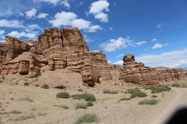
Notice the sand around the bottom. The New Mexico example of course has had rain water falling on it from above, leading to a different weathering and cracking.
djellison
Feb 28 2021, 10:51 PM
Wow. You have to debayer and then stitch all 16 subframes.....but this is full resolution EECAM FHAZ and RHAZ images.
Tom Dahl
Mar 1 2021, 12:39 AM
Mattias Malmer has created a short Virtual Reality-type video from early surface images. Here is a
tweet from him with the video.
bdshort
Mar 1 2021, 02:46 AM
QUOTE (Tom Dahl @ Feb 28 2021, 03:39 PM)
Mattias Malmer has created a short Virtual Reality-type video from early surface images. Here is a
tweet from him with the video.As a huge VR fan, this is the kind of stuff I'm looking forward to seeing more of. Any idea of what software is needed to view the VR images? The best I've seen so far is a VR scene from Curiosity viewable in the SteamVR Home app.
Andreas Plesch
Mar 1 2021, 05:32 AM
As I think the rover downlook descent frames are currently one of the highest resolution map images of the area, I went ahead and registered as precisely as I could, a frame looking straight down, one of the earlier ones which still captured a larger area. It turned to be around a 100m wide. Here is the registered map with the frame embedded into the 25cm resolution HiRISE mosaic:
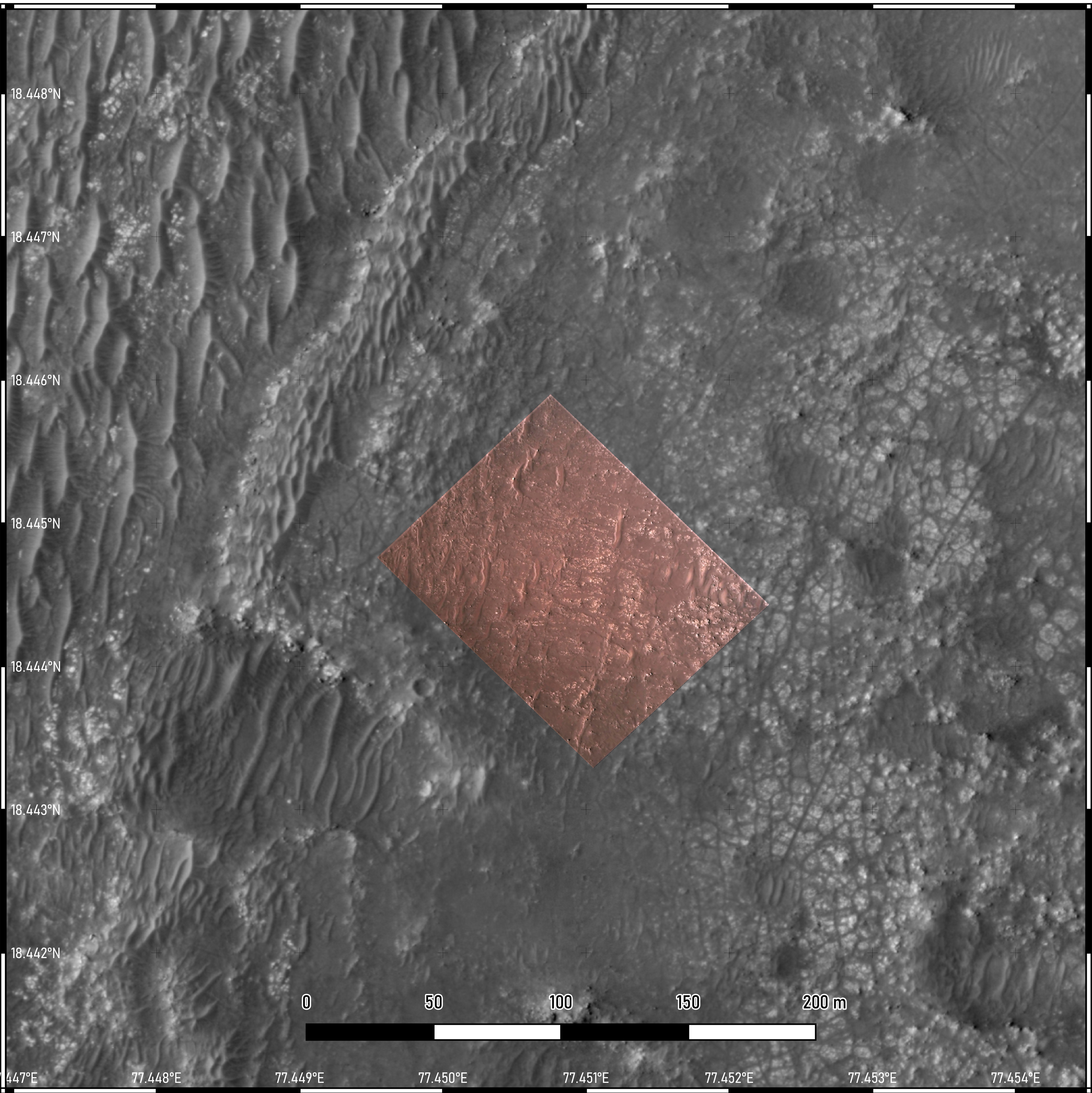
The downlook map has about 10cm resolution. It should be sufficient to resolve individual boulders, and may help locating those seen in the recent panoramas.
I then draped the map onto the 1m HiRISE mosaic DEM and made some perspectives, with 5x vertical exaggeration, to get a feel for subtle topography in the immediate surroundings:
Context:

Looking NW towards the dune field:

Looking due N at the immediate vicinity:
The rover is to scale, and at about the correct location.
It would be possible to go through the same procedure for closer up downlook map views. It would help with more precisely locating small features but I am not sure how useful the added precision would be.
Sean
Mar 1 2021, 04:21 PM
JRehling
Mar 1 2021, 05:12 PM
Perhaps this has been noted elsewhere and I missed it, but the degree to which the dust in the air is obscuring distant landscape seems much greater than has been typical for Spirit, Curiosity, etc.
stevesliva
Mar 1 2021, 06:23 PM
News is quiet. Looks like Curiosity first moved around sol 15 or 16... so that would be ~week from now. There are no more scheduled press conferences, right?
Andreas Plesch
Mar 1 2021, 06:26 PM
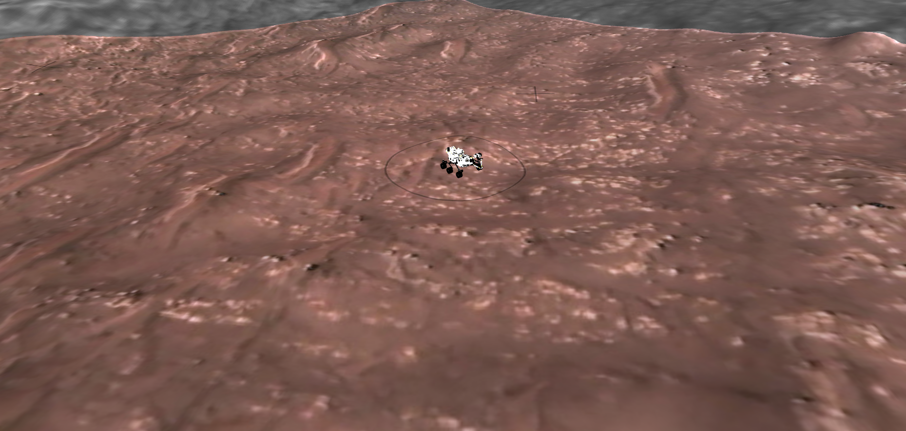
It turns out it is definitely possible to correlate boulders, dunes and bright pavement seen on the panoramas with the registered rover downlook map I made. This means it becomes easy to determine locations and measure distances between features. Here is an example using the wind carved walrus boulder (circled in blue):
Panorama:

Map:

Steve G
Mar 1 2021, 07:02 PM
Has there been any confirmation that the arm has been deployed and working? There hasn't been any images released from The WATSON camera, and I haven't seen the arm deployed by the navigation cameras yet.
mcaplinger
Mar 1 2021, 07:13 PM
QUOTE (Steve G @ Mar 1 2021, 11:02 AM)
Has there been any confirmation that the arm has been deployed and working?
On MSL, the arm wasn't moved until 14 days after landing, so if the same holds you shouldn't expect this quite yet.
erwan
Mar 1 2021, 07:52 PM
QUOTE (Sean @ Mar 1 2021, 05:21 PM)
This Is Mars
30 minutes uninterrupted on the surface of Mars in 4k UHD
I denoised, repaired, graded, stitched and composited all together in After Effects.
Thank you Sean, your video is absolutely stunning, beaufiful, wonderfuly edited.
MERovingian
Mar 1 2021, 08:28 PM
[quote name='Sean' date='Mar 1 2021, 05:21 PM' post='250423']
This Is Mars
30 minutes uninterrupted on the surface of Mars in 4k UHD
I denoised, repaired, graded, stitched and composited all together in After Effects.
Thank you so very much for this amazing, breathtaking work Sean! It's really like standing there, marveling.. Bravo!!
Greenish
Mar 2 2021, 05:20 AM
Crosseye stereo GIF of
MEDA deployment from NAVCAMs, sol 10.
Click to view attachment
MarkL
Mar 2 2021, 05:41 AM
QUOTE (Blue Sky @ Feb 28 2021, 10:58 PM)
Very similar structures can be seen in the New Mexico desert. I am guessing that the wind swirls around in complex patterns and erodes some places more than others.
Notice the sand around the bottom. The New Mexico example of course has had rain water falling on it from above, leading to a different weathering and cracking.
This is really nice to see - thanks. Amazing actually, and we will see how close an analog it is once the rover gets closer in to the scene which will be very exciting indeed. Just to see what is actually between the strata/clinothems and what the rock is made of. These are not the carbonates yet are they? I think those are up on the crater rim. They may find some samples at the entrance to the crater perhaps.
This mission will be a geologists dream I expect, even more than Curiosity.
MahFL
Mar 2 2021, 07:14 AM
I did not know MEDA was stowed inside those covers and had to be deployed.
xflare
Mar 2 2021, 08:05 AM
QUOTE (MahFL @ Mar 2 2021, 07:14 AM)
I did not know MEDA was stowed inside those covers and had to be deployed.
I think the similar instrument on Curiosity was slightly damaged by flying debris during landing.
James Sorenson
Mar 2 2021, 08:27 AM
A Sol-9 Full Navcam image. I'm just really blown away by these ECAM's as well as Mastcam-Z.


MahFL
Mar 2 2021, 09:43 AM
QUOTE (xflare @ Mar 2 2021, 08:05 AM)
I think the similar instrument on Curiosity was slightly damaged by flying debris during landing.
I believe it was non operational due to the damage.
Explorer1
Mar 2 2021, 01:59 PM
Only one of the two wind sensors was damaged; not the entire instrument. Still, glad to see it deployed!
Blue Sky
Mar 2 2021, 04:50 PM
QUOTE (Sean @ Mar 1 2021, 11:21 AM)
This Is Mars
If that is a full 360 degrees in 31 minutes, then we should be able to correlate timestamps with directions, and then with objects on the map. What is the direction to the flat-topped mesa with the layering seen at 22:44?
Phil Stooke
Mar 2 2021, 05:38 PM
You might want to compare the video with posts 340 or 397 in this thread to estimate directions.
Phil
eliBonora
Mar 2 2021, 05:41 PM
This our versions of Mastcam-z panorama sol 4

MarkL
Mar 2 2021, 05:57 PM
QUOTE (eliBonora @ Mar 2 2021, 05:41 PM)
This our versions of Mastcam-z panorama sol 4
Gorgeous and incredibly detailed. Nice to see them all stacked like this. Can't get over the amount of sand/dust. It looks like the original delta was buried almost.
JRehling
Mar 2 2021, 10:05 PM
I know we'll find out sooner or later, but I'm incredibly curious about and uncertain about how they will pick an initial route when targets of interest are in so many different directions and choices made in one direction will disfavor other objectives in other directions ever being visited. If the plan is for the first, say 5km, headed ultimately west, to explore the southern (from our current perspective, left) side of the delta, it's going to be sad to miss out on a closer look of what is, to begin with, a more interesting-looking northern (right) side. Even a close pass by the outlier will be a bit off the path of some of the interesting things in the middle of the delta. To some extent, it's sure that the path will meander a bit to visit various sequences of objectives rather than head straight to the nth one, but all of these tradeoffs feel like they could be excruciating ones to make and leave us with a chance that the most interesting stuff was somewhere else.
This is what they sometimes call "a good problem to have" too many interesting things to explore nearby instead of too few!
stevesliva
Mar 2 2021, 10:10 PM
Re: 'ever' ... the fact that sample return might send another rover to this vicinity means things in the rearview hazcams have a nonzero chance of getting a closer look. Albeit small. This rover can be 'perseverance' and that one can be 'hindsight.'
Explorer1
Mar 3 2021, 12:13 AM
The fetch rover's priority will be finding and collecting the deposited samples as fast as possible, so even less of a chance for wanderlust than Perseverance has (and presumably with nothing but engineer cameras to examine anything closely). Maybe once the MAV launches, something neat can be done with it....
Blue Sky
Mar 3 2021, 03:29 AM
So Perseverence will have to not only collect the samples, but bring them back down to a flat area that the smaller fetch rover can get to. It could be a long trip back if the "good stuff" (real river/lake bottom) is only exposed up on the delta.
MahFL
Mar 3 2021, 04:24 AM
Sherlock images...
fredk
Mar 3 2021, 05:30 AM
And they deBayer quite nicely out of the box:
Click to view attachment
MahFL
Mar 3 2021, 05:58 AM
QUOTE (fredk @ Mar 3 2021, 06:30 AM)
And they deBayer quite nicely out of the box:
Looks like the cover might be in the closed position.
mcaplinger
Mar 3 2021, 07:32 AM
QUOTE (MahFL @ Mar 2 2021, 09:58 PM)
Looks like the cover might be in the closed position.
Um, yeah.
Click to view attachment
Phil Stooke
Mar 3 2021, 07:35 AM
"So Perseverence will have to not only collect the samples, but bring them back down to a flat area that the smaller fetch rover can get to. It could be a long trip back if the "good stuff" (real river/lake bottom) is only exposed up on the delta"
No, they have lots of areas already found which have potential for the cache sites. Somewhere on these threads I linked to some presentations from the Sample Caching Workshop held in January. They outline a possible traverse with sampling sites and caching sites - just a study but clearly showing the possibilities.
Phil
MahFL
Mar 3 2021, 09:54 AM
The arm moved.
Phil Stooke
Mar 3 2021, 09:10 PM
Just a note that when the first drive happens, a new thread will be set up to follow this one. Not long now.
Phil
neo56
Mar 3 2021, 09:34 PM
I completed the Mastcam-Z panorama taken on sol 3 with a synthetic sky to obtain this 360°x180° version of the panorama.
View it in virtual reality on
360Cities (full definition: 30564x15282) and
RoundMe (10000x5000).

neo56
Mar 4 2021, 08:32 AM
Movement of the arm and the turret yesterday (sol 12).
Click to view attachmentClick to view attachment
Marz
Mar 4 2021, 03:15 PM
"Mission team members from NASAs Jet Propulsion Laboratory in Southern California will discuss mission 'firsts' achieved so far and those to come in a media teleconference at 3:30 p.m. EST (12:30 p.m. PST) Friday, March 5."
https://mars.nasa.gov/news/8878/nasa-to-pro...e-mars-landing/
eliBonora
Mar 4 2021, 05:44 PM
Today we tried the processing of this panorama sol 11

also in anaglyph version

Saturns Moon Titan
Mar 4 2021, 06:57 PM
The first LCAM (terrain relative navigation camera) images are coming down - so atmospheric with the haze!
https://photojournal.jpl.nasa.gov/catalog/PIA24447Click to view attachment
kenny
Mar 4 2021, 08:14 PM
What a stunning and evocative image - it just seems to shout "Planetary Exploration!" at the viewer...!
MahFL
Mar 4 2021, 10:45 PM
Looks like they moved the front right wheel.
jccwrt
Mar 5 2021, 02:08 AM
I made a colorized version of the LCAM photo, with colors estimated from color-corrected still frames from the EDL video cameras. The only exception is the dusty haze along the horizon, where the pink/blues of the lower atmosphere are blended with an estimated version of the lower atmosphere dust, incorporating sky colors from MastCam.
Click to view attachment
S Meyer
Mar 5 2021, 05:40 AM
I was playing with the HiRISE DTM as part of a project I am working on and thought this viewshed of what Perseverance can see might be of interest. The areas in pink/purple are what what the Mastcam can see assuming it is 2 meters off the ground.
I made this during the discussion about the shiny rock, but it took a while to make an account. My guess it that it is located at the edge of an eroded crater near the butte.
Click to view attachmentThis is my first time posting, hopefully I got the attachment right.
Scott
MahFL
Mar 5 2021, 11:12 AM
First drive.
john_s
Mar 5 2021, 03:06 PM
QUOTE (S Meyer @ Mar 4 2021, 10:40 PM)
I was playing with the HiRISE DTM as part of a project I am working on and thought this viewshed of what Perseverance can see might be of interest. The areas in pink/purple are what what the Mastcam can see assuming it is 2 meters off the ground.
Welcome Scott! Very nice to see the viewshed- please post (or point us to) more of it if you can.
John
eliBonora
Mar 5 2021, 03:10 PM
To remember the first movements of Perseverance
and also to improve the de-bayer!
nprev
Mar 5 2021, 11:08 PM
Now that she's becoming mobile, it's time for a new thread. Please start migrating events from sol 14 onward to Perseverance- Early Drives. Thanks!
This is a "lo-fi" version of our main content. To view the full version with more information, formatting and images, please
click here.


