
Full Version: Perseverance Lands In Jezero Crater
EDL microphone did not record data during EDL.
New color images on the raw page.
I had my rover too big in the landing site image above - but in the right place so that's something.
Phil
Phil
Mars is really picking on the microphones. The two previous ones sent; one on the Mars Polar Lander, which crashed, and Phoenix, which was never turned on, and now the EDL audio was lost on this mission.
Well done Phil! I was looking forward to this one.
Can't stop watching the EDL videos. Astounding, and yet just what you'd expect, and I for one got a bit emotional during Skycrane -- I hadn't registered that there were cameras on the descent stage and rover upper deck, pointing at each other, so that was quite unexpected.
Also interesting to compare to the various interpolated videos people (I forget who, sorry) made from the still frames from Curiousity's downward pointing camera. The first such that showed up on a search on YouTube was this -- the faked up audio is a slight twist of a small knife, but no matter, they'll get EDL audio next time no doubt )
)
https://www.youtube.com/watch?v=Esj5juUzhpU
Also interesting to compare to the various interpolated videos people (I forget who, sorry) made from the still frames from Curiousity's downward pointing camera. The first such that showed up on a search on YouTube was this -- the faked up audio is a slight twist of a small knife, but no matter, they'll get EDL audio next time no doubt
)https://www.youtube.com/watch?v=Esj5juUzhpU
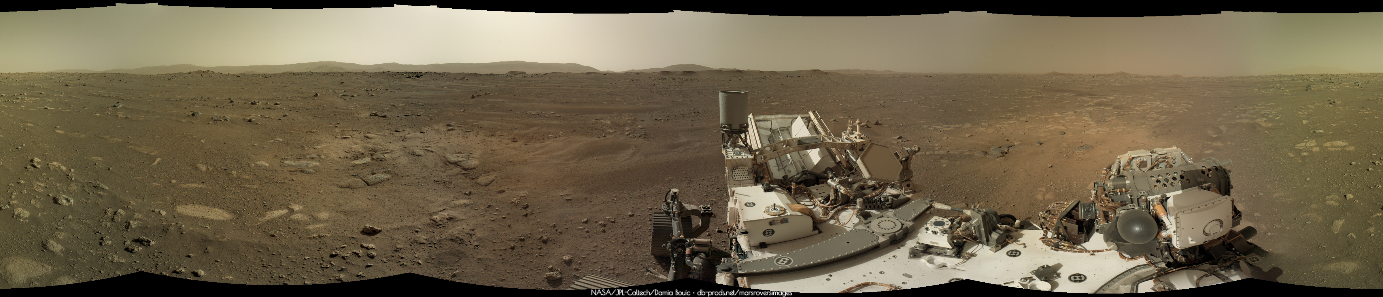
Amazing, Phil. This is quite the landing site with that scientifically portentous delta over there in the distance, and the crater rim much of the rest of the way around!
I played with the Navcams, it's fantastic to have them in color! But the large FOV will make it more difficult to stitch them together.


There's been a new batch of color navcams posted on the raw site, but these ones have an odd blue hue to them. Example.
I hope it's a raw image site issue and not something with the camera.
I hope it's a raw image site issue and not something with the camera.
My first attempt at a quick and dirty anaglyph. Most Nav cam shots are only from the left. This was one I found with both left and right. Not sure if they are a perfect match but it gives some sense of the distance of things.
 Perseverance Navcam Anaglyph 1
Perseverance Navcam Anaglyph 1
Joey Murphy has found a morse code message in the parachute pattern:
Click to view attachment
https://twitter.com/spacecomm_joey/status/1...0466644995?s=21
Now I can back to enjoying the images. You guys here are wizards.
Click to view attachment
https://twitter.com/spacecomm_joey/status/1...0466644995?s=21
Now I can back to enjoying the images. You guys here are wizards.
QUOTE
ugordan
There's been a new batch of color navcams posted on the raw site, but these ones have an odd blue hue to them.
There's been a new batch of color navcams posted on the raw site, but these ones have an odd blue hue to them.
If I click on color processed nothing comes up.
Ima guess these are blue because they are unadjusted.
QUOTE (Art Martin @ Feb 22 2021, 11:20 PM) 
My first attempt at a quick and dirty anaglyph. Most Nav cam shots are only from the left. This was one I found with both left and right. Not sure if they are a perfect match but it gives some sense of the distance of things.
The rise of the slope between Percy and the valley is quite a bit greater than it first appears.
QUOTE (Marvin @ Feb 22 2021, 03:01 PM)
Joey Murphy has found a morse code message in the parachute pattern:
Click to view attachment
https://twitter.com/spacecomm_joey/status/1...0466644995?s=21
Now I can back to enjoying the images. You guys here are wizards.
Click to view attachment
https://twitter.com/spacecomm_joey/status/1...0466644995?s=21
Now I can back to enjoying the images. You guys here are wizards.
I don't think that's the real code. (If you follow the scheme given--red = dit, white = dah--it actually spells out "BPL".
It looks instead like there are 71 4-bit words, in 3 groups of (37, 17, 17).
Not ASCII, AFAICT.
Is that the northern delta-fan in this image? I know we're headed to the western delta, but was curious if and when percy may get a better view.
QUOTE (neo56 @ Feb 22 2021, 05:10 PM)
I played with the Navcams, it's fantastic to have them in color! But the large FOV will make it more difficult to stitch them together.
QUOTE (Tom Ames @ Feb 22 2021, 04:45 PM)
I don't think that's the real code.
https://mobile.twitter.com/FrenchTech_paf/s...992051734478852
There may be more stuff though.
QUOTE (Pando @ Feb 22 2021, 01:28 PM)
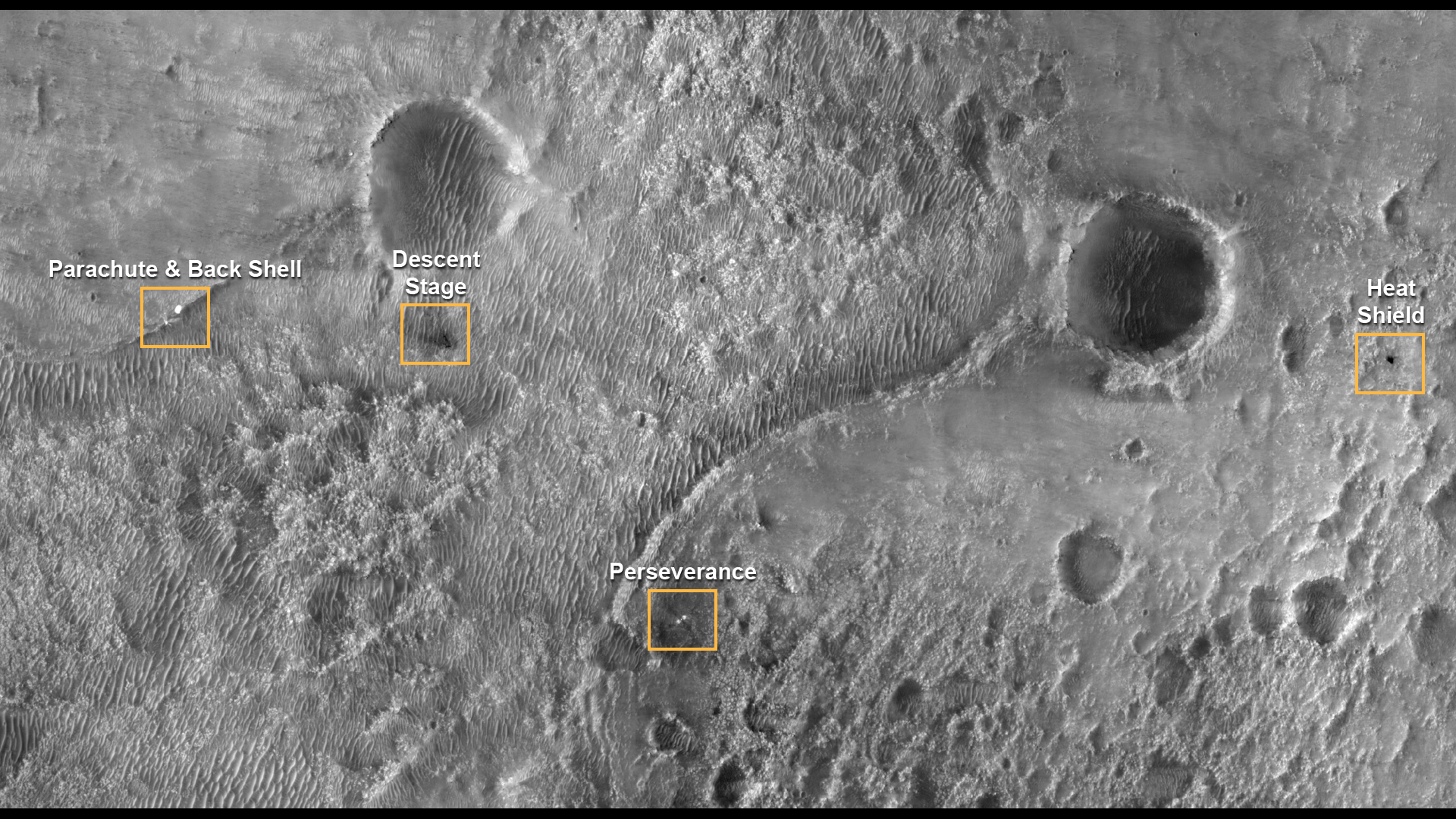
All the parts on the surface
https://mars.nasa.gov/resources/25630/perse...on-the-surface/
https://mars.nasa.gov/resources/25630/perse...on-the-surface/
It looks like the parachute/backshell got caught straddling that little ridge, might be hard to reach it if that is a target, but should be visible to supercam once we get a few tens of meters past the foreground, i think in the direction of this Navcam view ?
Click to view attachment
QUOTE (ugordan @ Feb 22 2021, 05:17 PM)
There's been a new batch of color navcams posted on the raw site, but these ones have an odd blue hue to them. Example.
I hope it's a raw image site issue and not something with the camera.
I hope it's a raw image site issue and not something with the camera.
I get an error message when I click on the example link.
You can definitely see something in the NavCam panorama released today. Likely the backshell.
This guy and his father solved the parachute message riddle:
https://mobile.twitter.com/FrenchTech_paf/s...992051734478852
It was an A=1, B=2 encoding, using 10-bit numbers.
https://mobile.twitter.com/FrenchTech_paf/s...992051734478852
It was an A=1, B=2 encoding, using 10-bit numbers.
QUOTE (Phil Stooke @ Feb 22 2021, 09:55 PM)
OK, now we know we are really on Mars - first circular panorama.
Interesting how the blasted areas are lighter than the pristine areas - from my recollection usually the dust is lighter so the ground darkens when you remove the dust.
This navcam is a crop at full resolution, and standard deBayering works fine:
Click to view attachment
But the hue is wonky out of the box.
This is 1/16th of a full frame! I wonder if we'll ever see a full-res full frame sent down.
Click to view attachment
But the hue is wonky out of the box.
This is 1/16th of a full frame! I wonder if we'll ever see a full-res full frame sent down.
QUOTE (Steve G @ Feb 22 2021, 08:16 PM)
You can definitely see something in the NavCam panorama released today. Likely the backshell.
Nice catch! Curiosity's hardware was hidden by local topography the entire time it was on the crater floor. The backshell is also between the landing site and delta, so perhaps a higher chance of sneaking a peak during the traverse? The dunes don't look that bad in the MRO imagery, with plenty of hard ground between them to navigate.
The deck is remarkably clean after landing compared to Curiosity's experience.
QUOTE (Steve G @ Feb 23 2021, 02:16 AM)
You can definitely see something in the NavCam panorama released today. Likely the backshell.
That sure looks like something, but the bearing is WSW, whereas the backshell should be to the WNW according to the hirise image.
Steve G - I'm pretty sure that is the backshell too.
The sightlines to the southernmost closest delta match up (well... with my 6-inch rule on my monitor and my map of Jezero at least)
Click to view attachment
EDIT
Sol-1 rear Hazcam
Click to view attachment
...well will see...
The sightlines to the southernmost closest delta match up (well... with my 6-inch rule on my monitor and my map of Jezero at least)
Click to view attachment
EDIT
Sol-1 rear Hazcam
Click to view attachment
...well will see...
The "forbidden zone" they want to circumnavigate looks a lot more benign from the ground than the HIRISE orbital imagery.
Ive spent some time georeferencing the available images, here is the result (edit: now available in jp2 format)
I'd eyeball the error to be ~2-4m
You can import the gtiff file to any gis and measure distance and bearing accurately, maybe it'll help locating the debris
Rough locations in decimal lat long:
Parachute: 77.4319, 18.4517
Descent stage: 77.4418, 18.4522
Heatshield: 77.4743, 18.4553
Perseverance: 77.4508, 18.4446
Is there a release date for the raw products with the labels in them?
QUOTE (PDP8E @ Feb 22 2021, 06:08 PM)
Steve G - I'm pretty sure that is the backshell too.
The sightlines to the southernmost closest delta match up (well... with my 6-inch rule on my monitor and my map of Jezero at least)
EDIT
Sol-1 rear Hazcam
...well will see...
The sightlines to the southernmost closest delta match up (well... with my 6-inch rule on my monitor and my map of Jezero at least)
EDIT
Sol-1 rear Hazcam
...well will see...
It doesn't match up with any known debris.
I've annotated the panorama showing roughly where the debris should be on the horizon. Unfortunately nothing is visible due to topography.
Image credit: NASA/JPL-Caltech
Odd quirk to the mystery object: It appears to be reflecting light on the side that, on all of the rocks in the vicinity, is shaded. That seems to imply a very reflective surface on a flat object. But we're close to the limit of resolution to pick out useful details.
Setting sun on Sol4.
right, it does seem to have the wrong side shaded, given the limit of resolution. It shows up in all 3 of the image pairs taken in that minute or so sequence, but shows up best in the darkest set, so if it truly doesnt map out to a piece of EDL hardware and is a chance glint off a polished rock face, it should be unnoticeable once an image with the sun at a different angle comes down. The crosseye/anaglyph/parallel view shows its indeed on the further of those ridges:
Click to view attachment Click to view attachment Click to view attachment
Click to view attachment Click to view attachment Click to view attachment
Here's a before-and-after gif animation of the skycrane debris field (needs to be clicked to animate):
Click to view attachment
I wish the source image was of higher quality, but you can still make out quite a few pieces scattered about.
Click to view attachment
I wish the source image was of higher quality, but you can still make out quite a few pieces scattered about.
Nice animation!
Regarding the bright feature on the near horizon. The bright side is not facing the other way compared with nearby rocks. Note that many rocks in the area have a bright flat top. The extra-bright feature is sloping towards us and to the left a bit, but it's getting its upper (sloping) surface illuminated. Some foreground rocks have a very bright right side but the other faces are in shadow because they are near-vertical. There is nothing off about the illumination, it's just the rock shapes.
Phil
QUOTE (Tom Tamlyn @ Feb 23 2021, 02:11 AM)
I get an error message when I click on the example link.
Yes, those images seem to have been pulled. I can't find the corresponding-looking Navcam-L image anymore.
QUOTE (markril @ Feb 23 2021, 08:16 AM)
... but you can still make out quite a few pieces scattered about.
Thank you for this good Gif.
I admit that I have a hard time distinguishing them. But living near Paris (France) Im probably far too far away.
QUOTE (Phil Stooke @ Feb 23 2021, 08:53 AM)
Nice animation!
Regarding the bright feature on the near horizon. The bright side is not facing the other way compared with nearby rocks. Note that many rocks in the area have a bright flat top. The extra-bright feature is sloping towards us and to the left a bit, but it's getting its upper (sloping) surface illuminated. Some foreground rocks have a very bright right side but the other faces are in shadow because they are near-vertical. There is nothing off about the illumination, it's just the rock shapes.
Phil
Regarding the bright feature on the near horizon. The bright side is not facing the other way compared with nearby rocks. Note that many rocks in the area have a bright flat top. The extra-bright feature is sloping towards us and to the left a bit, but it's getting its upper (sloping) surface illuminated. Some foreground rocks have a very bright right side but the other faces are in shadow because they are near-vertical. There is nothing off about the illumination, it's just the rock shapes.
Phil
Back when Oppy was driving to Victoria crater we had such rock we called « The Beacon » that proved to be a rock. We had a lot of arguments and a lot of fun with it until weve been close enough to be sure what it was. Are you saying weve got another beacon here ?
I zoomed in, with some quick enhancements. I like the rock with a reflective side idea...
Click to view attachment
Click to view attachment
My first attempt at stitching the full panoramic from Navcam, Sol 2. So far, so good, but still perfectible. I'll try adding the bottom part of the rover deck later.
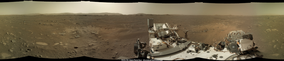
With panoramas, having compass bearing on the pictures would help a lot with coordinating what we see with what's on the map. I do not know if this is achievable without the product label (tell me)
like we have with MSL, but unfortunately that has to go through JPL MIPL which is apparently very secretive. JPL really is conservative when it comes to releasing their code.
like we have with MSL, but unfortunately that has to go through JPL MIPL which is apparently very secretive. JPL really is conservative when it comes to releasing their code.
Right Rear Hazcam, Sol 0, processed to emphasize differences in saturation.
So in everyone of the images their appears to be a faint object in the air. Im sort of ruling out a spec of dust because its the same altitude in every shot...but im no expert
Could that be diemos? Just wondering.
You gotta look hard or you will miss it in the sky
https://db-prods.net/marsroversimages/Perse...1/Sol2_pano.jpg
If it's in every image in the same spot, then it is certainly a speck of dust! Couldn't be anything else.
If you mean the dark spot, for sure not Deimos, since that would not appear dark (it's surface would be just slightly brighter than the sky since it's light would be added to that of the sky and likely invisible in navcam during the day). Dust speck is a good bet.
QUOTE (erentar @ Feb 23 2021, 04:59 AM)
like we have with MSL, but unfortunately that has to go through JPL MIPL which is apparently very secretive. JPL really is conservative when it comes to releasing their code.
There are reasons to be critical about how things have gone in terms of getting data out to the public over the past few days. But this is absolutely untrue.
Those mosaics from Curiosity are auto-generated after images are received after every drive, and every time there are updated images to add to them. They get sent out to the MSL internal server, a thumbnail gets emailed out to the team, and it gets uploaded to the MSL public website all using the same end-of-pass script. https://mars.nasa.gov/msl/multimedia/mosaics/ . This is not very secretive. Its about as proactively open as its possible to be. It happens entirely hands off - no human in the loop - automatically. If I have been on shift sequencing images ...that public website is the place I go to see the end result first thing in the morning. I would expect that M2020 will probably get to the same point in the near future.
MIPL isnt secretive. They have posters and presentations about their work at almost every planetary science conference Ive seen. See https://trs.jpl.nasa.gov/handle/2014/42355 for example. As for conservative when it comes to releasing their code - most of the MIPL code base is open source
https://www-mipl.jpl.nasa.gov/vicar_open.html
This is a "lo-fi" version of our main content. To view the full version with more information, formatting and images, please click here.