jamescanvin
Aug 6 2014, 09:30 PM
The ~85m drive on sol 3744 was uphill, starting the long climb of Cape Tribulation.

The sol 3744 Drive:
Click to view attachmentPuts Opportunity about here on a plot with colour for elevation:
Click to view attachmentThe view ahead:
Click to view attachment 
Phil Stooke
Aug 6 2014, 10:29 PM
Right! This is where I have it. (proper map update later)
Phil
Click to view attachmentClick to view attachment
Phil Stooke
Aug 9 2014, 03:29 PM
A circular view of a partial panorama from sol 3746.
Phil
Click to view attachment
Floyd
Aug 9 2014, 11:18 PM
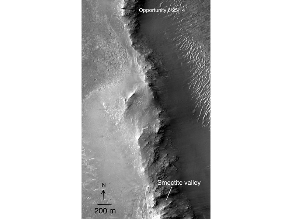
Do we know if Opportunity will be traveling east or west around Wdowiak Ridge [name corrected]?
ngunn
Aug 9 2014, 11:32 PM
It won't be east. The slopes on the inside of the crater are too steep. I don't know if they want to visit that outcrop but if they do I'd expect they'd sneak up on it from the right (west) where the gradients are less severe
Floyd
Aug 10 2014, 12:03 AM
I'm not sure as the Eastern side is actually 200 m from the drop into the crater.
fredk
Aug 10 2014, 01:13 AM
I'd say the east side is doable. Remember
this image in a recent
Crumpler blog that has a dashed green line following the eastern ridgeline up and then turning west to get behind Cape Stevens. There was no description of that dashed line, but we've also heard that several options were being considered.
jvandriel
Aug 10 2014, 01:45 PM
The Pancam L7 view on Sol 3746.
Jan van Driel
Click to view attachment
Phil Stooke
Aug 10 2014, 03:21 PM
OK... I was wrong. I saw the observation name cape Stevens and assumed it might be the rocky ridge south of us. Not so - it was a bit of outcrop near the rover. The big ridge is called Wdowiak Ridge. I will correct the map soon.
Phil
ngunn
Aug 11 2014, 03:10 PM
fredk
Aug 11 2014, 03:35 PM
Yeah!
And with this last drive we've really climbed - we're getting back up towards the elevation of Broken Hills, as you can see from these hazcam views:
Click to view attachment
Phil Stooke
Aug 11 2014, 04:41 PM
A quick circular view of sol 3749. The foreground features give a pretty good location.
Phil
Click to view attachment
jvandriel
Aug 11 2014, 06:10 PM
The Sol 3749 L0 Navcam view.
Jan van Driel
Click to view attachment
jamescanvin
Aug 12 2014, 07:53 AM
Did anyone else get a feeling of deja-vu when seeing the navcams yesterday?
 Click to view attachment
jamescanvin
Aug 12 2014, 12:59 PM
Closing in on Wdowiak Ridge!
Phil Stooke
Aug 12 2014, 03:13 PM
A quick circular view of the sol 3750 images to help locate us.
Phil
Click to view attachment
jvandriel
Aug 12 2014, 07:14 PM
The Navcam panoramic view on Sol 3750.
Jan van Driel
Click to view attachment
atomoid
Aug 12 2014, 08:55 PM
QUOTE (ngunn @ Aug 11 2014, 07:10 AM)

indeed that is a great view in crosseye too!
Click to view attachment
mhoward
Aug 13 2014, 12:25 PM
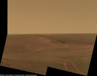
Another drive on Sol 3751, and she's passing by.
climber
Aug 13 2014, 01:18 PM
Still possible to investigate from the top and less risky. We'll see.
Phil Stooke
Aug 13 2014, 03:03 PM
That is what i would expect to see.
Phil
jvandriel
Aug 13 2014, 03:13 PM
Sol 3750
Added 1 image.
Jan van Driel
Click to view attachment
mhoward
Aug 13 2014, 04:41 PM
I didn't mean that she won't check out Wdowiak Ridge (I don't know); just that she's literally passing alongside the thing at the moment.
atomoid
Aug 14 2014, 01:34 AM
really pleasing sky exposure in these
sol3751 pics, i can just relax in a beach chair with the cool radiation pleasantly peppering my molecules
heres a stitch with a little shadow fill for Wdowiak
Click to view attachment
vikingmars
Aug 14 2014, 07:29 AM
QUOTE (climber @ Aug 13 2014, 03:18 PM)
Still possible to investigate from the top and less risky. We'll see.
A panoramic view would be gorgeous to see from the Wdowiak Ridge : if it cannot reach its summit, Oppy should rove at least a few tens of meters on it and/or take panoramic pictures from the rim of the crater standing at the beginning of the ridge itself (that may be also interesting to see on a scientific point of view for its geological layers).
Spectacular views help us a lot doing our Mars EPO campaigns in France...
Click to view attachment
jvandriel
Aug 14 2014, 09:44 AM
The Navcam L0 view on Sol 3751.
Jan van Driel
Click to view attachment
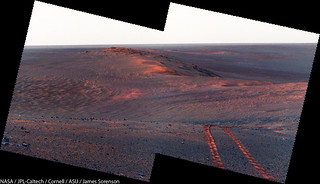
fredk
Aug 14 2014, 02:07 PM
Incredible view now looking back - we can see that we're higher than Solander Point/Murray Ridge now, and so at our highest point yet at Endeavour:
http://qt.exploratorium.edu/mars/opportuni...0M1.JPG?sol3752A reminder of the early views we had of Wdowiak Ridge - I think this was the first ID of it:
http://www.unmannedspaceflight.com/index.p...st&p=176029
jvandriel
Aug 14 2014, 06:51 PM
The Navcam panoramic view on Sol 3752.
Jan van Driel
Click to view attachment
jvandriel
Aug 14 2014, 07:09 PM
and another view on Sol 3752.
Jan van Driel
Click to view attachment
Phil Stooke
Aug 14 2014, 07:33 PM
Nice panoramas, as usual! Here is a circular projection.
Phil
Click to view attachment
atomoid
Aug 14 2014, 08:41 PM
Fredk, many thanks for the
retrospectacle of early views of Solander, love seeing those..
nice look back
sol3752 (perhaps this view even includes the spot where
that photo was taken) and below in xeye, movin' on up!
Click to view attachment
neo56
Aug 15 2014, 01:18 PM
Wow, really nice crossed-eyes, thanks atomoid !
jvandriel
Aug 15 2014, 08:14 PM
Sol 3752-3753
Added 2 images for the complete view.
Jan van Driel
Click to view attachment
atomoid
Aug 15 2014, 09:10 PM
slightly windtailed
rock of interest
sol3753 set 90cw rotated for crosseye
Click to view attachment
fredk
Aug 16 2014, 02:37 PM
Some interesting information in the latest
Crumpler blog.The plan is to inspect the rocks that have come down the scree slope where we are now. After that there's a nice proposed route map taking us along the south side of Wdowiak to Ulysses crater and then on to Marathon valley.
QUOTE
We have two options: (1) take our time and pull into Marathon Valley just before winter shuts everything down, or (2) make rapid progress and arrive at Marathon Valley early enough in the season that we can do some sight-seeing before weather shuts things down.
That's clearly being very conservative - this past winter certainly didn't shut us down!
centsworth_II
Aug 16 2014, 03:35 PM
QUOTE (fredk @ Aug 16 2014, 10:37 AM)
...this past winter certainly didn't shut us down!
Perhaps Marathon Valley itself will be off limits during the winter and that is what he is refering to. I really like those Crumpler posts!
serpens
Aug 16 2014, 11:25 PM
Anyone have any information on the Marathon valley contours? I guess that they cannot assume that Marathon Valley and approaches will have the same superb cleaning environment as was the case last winter and Opportunity could well have a stationary mid winter sojourn as was the case on Cape York. Plan for the worst case and be pleasantly surprised if things are better. Couldn't agree more with respect to Larry Crumpler's blog.
fredk
Aug 18 2014, 04:32 PM
The winter at CY was the only one out of six Oppy needed to hunker down, so even without the intense gusts we've had this winter there's good reason to be optimistic for next winter. But of course they must plan for the possibility.
Finally some new images - here's our first real closeup of the rock face in front of us:
Click to view attachment
James Sorenson
Aug 18 2014, 05:10 PM
CODE
03756 11:59:36 189 164 469 p2380.34 4 pancam_Wdowiak_Ridge_pt1_4x1_L257R2
Looks like that image is for the first part of a color panorama. This shall be a scenic one!
fredk
Aug 19 2014, 09:09 PM
Floyd
Aug 19 2014, 10:00 PM
This is nice--fun to follow those tracks... Great images...
walfy
Aug 19 2014, 10:46 PM
QUOTE (fredk @ Aug 19 2014, 01:09 PM)
Really nice shots! Here's one in 3D from the NavCam a few sols earlier:
Click to view attachmentLooking forward to more shots from these heights.
Astro0
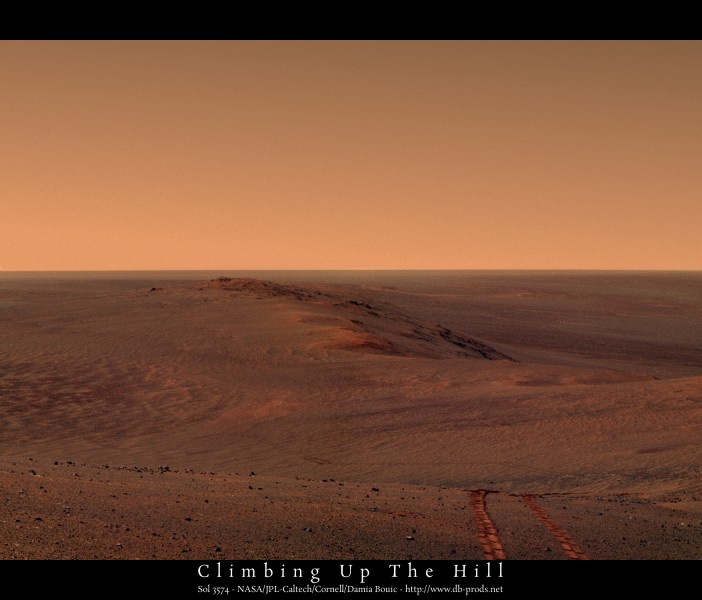
Aug 20 2014, 12:56 AM
Making tracks - sol3754
 Click to view attachment
atomoid
Aug 20 2014, 01:37 AM
Nice stitch, i've been waiting YEARS to see a view like this with an intervening mountain lower than the horizon. but thought we'd have to be higher up Cape Tribulation, pleasant surprise!
would be great to get a super-res of this overlaid with map tracks and SOLs all the way back to the location of Crumplers
traverse map Cape York vanatage point.
fredk
Aug 20 2014, 02:18 AM
Thanks, Astro0! Stunning stitch - this is one of the best views of the mission.
Sketching our path would be very cool - not only would it extend to Cape York, but also back across the great Dune Sea, since we could see Wdowiak Ridge from quite a ways back.
James Sorenson
Aug 20 2014, 03:38 AM
My take.
And a false color to better show the tracks.
Astro0
Aug 20 2014, 04:23 AM
We bow to your genius. Beautiful!
Phil Stooke
Aug 20 2014, 04:29 AM
I bow too.
Phil
vikingmars
Aug 20 2014, 09:07 AM
Ant103
Aug 20 2014, 10:23 AM
Very good James
My take, in Poscard format
This is a "lo-fi" version of our main content. To view the full version with more information, formatting and images, please
click here.