Worf again? or more like these guys
Click to view attachment
Full Version: Cape Tribulation
Less than 1% flash storage space lost in the reformat. Couldn't ask for a better result. The dust factor is gradually decreasing (now 0.754) so Opportunity is back in a net deposition zone. Potentially I guess, she could always nip across closer to the rim edge in search of wind if required. Always nice to have options.
The Navcam and Pancam Panoramas taken on Sol 3783.
Jan van Driel
Navcam L2
Click to view attachment
Pancam L7
Click to view attachment
Jan van Driel
Navcam L2
Click to view attachment
Pancam L7
Click to view attachment
Starting to peek into Ulysses crater on sol 3785:
Click to view attachment
Click to view attachment
Very nice!
Phil
Phil
Very interesting passage, a change of landform from sandy to rocky land with many small stones. I think that by that zone has stronger constant wind than the rest places.
Here is the complete Stereo Pancam panoramic view taken on Sol 3785.
Jan van Driel
Click to view attachment
Jan van Driel
Click to view attachment
Great, Jan - I put the two scenes together for this circular view which will let me update the map later today.
Phil
Click to view attachment
Phil
Click to view attachment
That circular pan also makes clearly visible how much we've climbed and the opening of a more distant horizon. It might be rewarding to apply non-circular Phil-o-vision to a couple of the original navcam frames as you've done in the past to elucidate plains topography. I hope soon we may scan the horizon to the southwest where distant landmarks first seen from around Concepcion must surely be visible once more.
Any quick numbers on the the actual slope/grades Oppy's been accomplishing of late...? Steepest yet...?
Go Oppy, our resilient one...!
Go Oppy, our resilient one...!
These are quite modest slopes. Remember Victoria and Endurance?
Paolo
Paolo
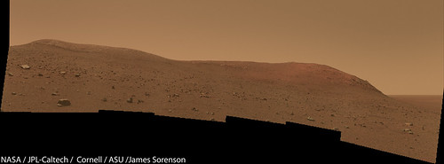
Wdowiak Ridge. 
QUOTE (James Sorenson @ Sep 18 2014, 07:01 AM) 
Wdowiak Ridge.
How nice ! Thanks a lot James !
This is a Pancam frame from sol 3786. At A there is a bright fuzzy marking which doesn't appear to be on a previous view (sadly, only a half-resolution albedo pan image from sol 3776) - maybe a wind gust in action. At first I thought the feature at B was another - a vertical column of dust. But no, it does show in the earlier image, so it's a surface marking.
Anyhoo - maybe evidence for more wind activity.
Phil
Click to view attachment
Anyhoo - maybe evidence for more wind activity.
Phil
Click to view attachment
Is there a prevailing wind near and/or in Endeavour?
If those are crescent dunes to our immediate ESE (see Phil's map, eg) that suggests winds blowing from the WNW, although the winds may have changed since those dunes formed. But the orbital imagery also shows what look like wind streaks trailing to the east from the ridge to our east, consistent with a westerly wind. But the winds may be seasonal (I think they were at Victoria, eg) and happened to be from the west when that hirise image was taken.
Dunes farther inside Endeavour suggest winds from the NW.
If you looked carefully at closeup imagery of the ground from Oppy you might get a more local sense of wind directions.
Dunes farther inside Endeavour suggest winds from the NW.
If you looked carefully at closeup imagery of the ground from Oppy you might get a more local sense of wind directions.
Fred, you previously posted a nice animation showing a wind gust that seems to be SE.
Can't get the post link facility to work. Post #320 page 22 in topic: Cape York - Shoemaker Ridge and the NE traverse, Starting sol 2735
Can't get the post link facility to work. Post #320 page 22 in topic: Cape York - Shoemaker Ridge and the NE traverse, Starting sol 2735
I'd forgotten about that - here's the post link.
Since we're viewing that from CY, the gust seems to be moving from the south or even SSW. Maybe if you look at the morphology of the many other gusts we've seen you could infer something about their direction?
Since we're viewing that from CY, the gust seems to be moving from the south or even SSW. Maybe if you look at the morphology of the many other gusts we've seen you could infer something about their direction?
I don't think sifting through the images to find the few that show gusts would tell us much Fred. Chojnacki et al did a pretty thorough investigation of dune changes in Endeavour and inferred some aspects of wind direction.
http://onlinelibrary.wiley.com/doi/10.1029/2010JE003675/pdf
As may be expected the winds seem to be influenced by the time of year (stage of transport of atmosphere between poles) and day solar time. However, from the cleaning effect on Oppy there also seems to be local wind blowing out of the crater during the day, as was seen for Victoria. Choinacki's findings show winds stronger than any models predict but he bases his estimates on supposedly sandy dunes which in most cases show deflation not movement. This would seem to make saltation unlikely and possibly the dunes are dust/silt rather than sand with consequent reduction of perceived wind strength.
OH MYYYYY GOSHHH!!! 
http://qt.exploratorium.edu/mars/opportuni...QNP2396L2M1.JPG
A 10 pointing color panorama as well!
http://qt.exploratorium.edu/mars/opportuni...QNP2396L2M1.JPG
A 10 pointing color panorama as well!
I think we can see our tracks waaaay down there:
http://qt.exploratorium.edu/mars/opportuni...5M1.JPG?sol3786
http://qt.exploratorium.edu/mars/opportuni...5M1.JPG?sol3786
A partial L2 PanCam panorama from Sol3786
Some images missing from some filters but hopefully they were captured and will come down soon.
Click to view attachment
Some images missing from some filters but hopefully they were captured and will come down soon.
Click to view attachment
Very close to the rim of Odyssey now:
Click to view attachment
Click to view attachment
This is a circular version of Dig's 3787 panorama - it's a long way from being a simple polar reprojection, it took three goes to get the tilted surface to project into a more realistic map geometry. (rotated a bit too far, north is not at the top here but about 20 degrees clockwise)
Phil
Click to view attachment
Phil
Click to view attachment
Nice pan - I will play with it later. Meanwhile, Larry Crumpler's latest Field Notes is out, with a nice map of this location:
http://www.nmnaturalhistory.org/rover-fiel...-from-mars.html
Phil
http://www.nmnaturalhistory.org/rover-fiel...-from-mars.html
Phil
Larry Crumpler's latest Field Notes
I've never been able to open these (until they are re-hosted by The Planetary Society where of course they open fine). Do others experience this or is it just me? (Sorry to take up space with a computer bug thing but it's a long running annoyance that someone here may have a simple solution for.)
I've never been able to open these (until they are re-hosted by The Planetary Society where of course they open fine). Do others experience this or is it just me? (Sorry to take up space with a computer bug thing but it's a long running annoyance that someone here may have a simple solution for.)
They load fine here. Try a different browser ( I'm using Chrome - but it also loads fine in Firefox )
I'm on Firefox here and I get 'timed out' every time. I'll try on IE at work tomorrow.
What a beautiful vantage point we are at.

QUOTE (ngunn @ Sep 22 2014, 05:45 PM)
I'm on Firefox here and I get 'timed out' every time. I'll try on IE at work tomorrow.
Hate to say it, but clear cache and if that doesn't work, reset Firefox remembering what your fav addons are. Could be worse... On OSX Firefox seems to stop playing well with Google and Facebook in very short order. Has to do with one of my addons, and I'm not sure which yet.
Still closer to Ulysses:
Click to view attachment
Click to view attachment
QUOTE (ngunn @ Sep 22 2014, 02:33 PM)
Larry Crumpler's latest Field Notes...I've never been able to open these...
the previous page link had no protocol prefix embedded, not that it should matter (doesnt on my machine anyway), try: http://www.nmnaturalhistory.org/rover-fiel...-from-mars.html oh, i see this forum software just removes those anyway, so never mind... i cant delete this now-pointless post so heres an overhead of Ulysses from Larry's site and the map as well so if you still cant load the main page, maybe that will work for you
Jan, you nearly could have posted this picture in Rosetta's topic and been unnoticed.
James: "Old Rover - New Heights"
Thank you!
Thank you!
Thank you James and Jan, both your images give a good impression of the rovers whereabouts.
And yes it's beautiful after all that flatland we've seen. =)
And yes it's beautiful after all that flatland we've seen. =)
Animation of the Sol 3784 drive, the latest long drive parallel to Wdowiak Ridge.
Begins with a CCW turn, then is a straight shot up the slope except for big bumps over rocks along the way.
The anaglyph version is a bit easier to follow because of the bumps.
Right click to show controls, pause, and rewind.
Left Navcam --- Anaglyph
Image from afterwards:
Click to view attachment
Begins with a CCW turn, then is a straight shot up the slope except for big bumps over rocks along the way.
The anaglyph version is a bit easier to follow because of the bumps.
Right click to show controls, pause, and rewind.
Left Navcam --- Anaglyph
Image from afterwards:
Click to view attachment
On Sol-3793 there was a 13 point color pan looking across Ulysses Crater.
EDIT: here is a mosaic of it using the image stamps from the tracking site.

EDIT: here is a mosaic of it using the image stamps from the tracking site.
This is a "lo-fi" version of our main content. To view the full version with more information, formatting and images, please click here.