3719 drive takes us further south, I'm guessing towards the next big outcrop on the right side of this frame:
http://qt.exploratorium.edu/mars/opportuni...0M1.JPG?sol3719
I like the parting shot of the broken hills area:
http://qt.exploratorium.edu/mars/opportuni...0M1.JPG?sol3719
Mods: it seems safe to say we're off of Murray Ridge now, so perhaps time for a new thread. On the other hand we still have a ways to go to get to Tribulation proper. Just a matter of drawing a line I guess.
Full Version: Exploring Murray Ridge
A magnificent place, a special moment, spectacular images from the rover, and perfect presentation: that one post exhibits them all. Still loomed over by the rocky eminence just visited we face the road ahead. If fredk is correct about the next waypoint it would seem that the chosen option is to 'follow the ridge'. I do hope that's right, even though it does mean losing height before climbing again. It's not only where the best rock outcrops are but also the best views.
Putting Jan's two panoramas together, I made this circular view to help locate the rover on 3719.
Phil
Click to view attachment
Phil
Click to view attachment
QUOTE (fredk @ Jul 12 2014, 04:56 AM) 
Just a matter of drawing a line I guess.
Certainly leaving the ridge and heading for Tribulation. Probably too short a passage to worry about a "The Journey to Cape Tribulation" thread

Thought it might be useful to pop in a couple of overview images to see where Opportunity is as of Sol 3719.

Click to view attachment Click to view attachment
QUOTE (Astro0 @ Jul 12 2014, 06:40 AM)
Probably too short a passage to worry about a "The Journey to Cape Tribulation" thread
Agreed - maybe once we clearly start climbing again would be a good place to draw the line...
Thanks Astro0, its deceptive how close the crater feature (named?) appears to loom just the other side of the dip.. but it would be like trekking all the way back to Pinnacle Island..
here are some attempts at capturing that topography via crosseyes comparing tosol's 3721 navcam pair (left), then wide-baseline (sol3718-sol3719 middle).
the third one at right (sol3718 and sol3721) actually seems to have lined up and isnt as wide as the sol3718-19 set..
Click to view attachment Click to view attachment Click to view attachment
The Sol-3719 3x1 Pancam mosaic.

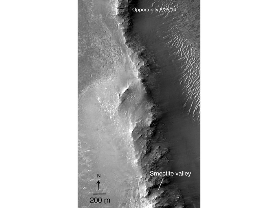
A bigger map showing Murray Ridge to Smectite Valley from A.J.S. Rayl's blog: Link Looks like we have about 3,000 m drive to get to Smectite Valley.
Pancam Sol 3723
Click to view attachment
Click to view attachment
Another look at the horizon with a super Phil-O-Vision.
Click to view attachment
Image: 1N458526786EFFCE0DP1828R0M1
Any better identification now that we're further along the rim?
An earlier look.
Click to view attachment
Image: 1N458526786EFFCE0DP1828R0M1
Any better identification now that we're further along the rim?
An earlier look.
A really good drive today, over 100 m according to Midnight Planets. This is a circular half pan - map update later.
Phil
Click to view attachment
Phil
Click to view attachment
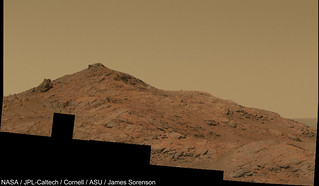
The Sol-3717 Pancam mosaic of "Broken Hills"

False Color

False Color
QUOTE (James Sorenson @ Jul 21 2014, 10:52 AM)
The Sol-3717 Pancam mosaic of "Broken Hills"
WOW ! Thanks so much James !

James, that is just beautiful!
For anyone following exploratorium, there was a weird glitch with some recent (3717 and 3718) images appearing in a 2004 folder:
http://qt.exploratorium.edu/mars/opportuni...cam/2004-02-12/
http://qt.exploratorium.edu/mars/opportuni...cam/2004-02-12/
QUOTE (jvandriel @ Jul 23 2014, 03:28 PM)
and the Navcam view on Sol 3730. Jan van Driel
Nice view Jan van Driel ! ...and now, we are climbing again !
This is a circular view of Jan's latest half-panorama. Using this and the previous one I have revised my location map.
Phil
Click to view attachment
Phil
Click to view attachment
2 Panoramic Navcam views taken on Sol 3732.
Jan van Driel
Click to view attachment
and a partial one.
Click to view attachment
Jan van Driel
Click to view attachment
and a partial one.
Click to view attachment
Really interesting textures at this rocky place - Rosebud Canyon.
Phil
http://www.midnightplanets.com/web/MERB/im..._P2955M2M1.html
Phil
http://www.midnightplanets.com/web/MERB/im..._P2955M2M1.html
sol3730 ripple crosseye
Click to view attachment
?a protrusion casting shadow just left of center in sol3730 R navcam? ..still waiting for the L half.
Click to view attachment
?a protrusion casting shadow just left of center in sol3730 R navcam? ..still waiting for the L half.
Good eye. To me it looks like a low rock in front of the taller rock. Instead of the ground under a protrusion, the bright sliver is the top of the low rock. And instead of the shadow of a protrusion, it's the front edge of the low rock, out of the sun.
But stereo should help settle it...
But stereo should help settle it...
http://www.jpl.nasa.gov/news/news.php?release=2014-245
QUOTE
NASA's Opportunity Mars rover, which landed on the Red Planet in 2004, now holds the off-Earth roving distance record after accruing 25 miles (40 kilometers) of driving. The previous record was held by the Soviet Union's Lunokhod 2 rover.
The Release on the 40 km (25 mile) mark for Oppy has a new graphic (showing Oppy on top) with the distance of a marathon noted ...
AND ...
A new name. From the large scale map (http://www.jpl.nasa.gov/spaceimages/details.php?id=pia18404) in appears that the valley of the smectites has been named:
Marathon Valley
AND ...
A new name. From the large scale map (http://www.jpl.nasa.gov/spaceimages/details.php?id=pia18404) in appears that the valley of the smectites has been named:
Marathon Valley
Here's the wonderful graphic showing Oppy's distance record against the rest:
http://www.jpl.nasa.gov/images/mer/2014-07...metry140728.jpg
http://www.jpl.nasa.gov/images/mer/2014-07...metry140728.jpg
Congrats Oppy and team on a well deserved record breaker!
Something I'm working on
A couple images missing so here is a screenshot. Will post when finished.
Something I'm working on
A couple images missing so here is a screenshot. Will post when finished.
I am sooooooooo surprised by this anouncement.
Lunokhod 2 distance is still "uncertain" and we all know here that the record is around 42 km and NOT 40.
We've been told that they'll made such anouncement once they'll be absolutely sure that Oppy's will have roved longer than Lunokhod 2.
So far we're absolutely sure this is not the case.
Go Oppy, go, 2 more to g
Edited. The one record that Oppy already hold is there: http://www.unmannedspaceflight.com/index.p...st&p=211003
I've been told that the Lunokod 2 odometry has been re-computed from LRO imagery to be 39.1 Km.
A nice basemap for Opportunity's travels is available. Also there are no firm plans post Marathon Valley.
According to JPL's press release:
Anyone know if this will be published?
QUOTE
Irina Karachevtseva at Moscow State University of Geodesy and Cartography's Extraterrestrial Laboratory in Russia, Brad Jolliff of Washington University in St. Louis, Tim Parker of JPL, and others collaborated to verify the map-based methods for computing distances are comparable for Lunokhod-2 and Opportunity.
Anyone know if this will be published?
We'd better wait for Phil GOD Stooke advice.
Reports of my deification have been much exaggerated, or at least are somewhat premature.
It looks as if the previous claim of 42 km has been dropped. I think everybody is agreeing with the new distance. I overlaid the tracks visible in LRO images on a soviet-era traverse map (that comparison might be on UMSF somewhere) and felt that the old distance of 37 km would need to be increased, but I was surprised when the 42 km distance was announced. 39 km looks more like it to me.
Phil
QUOTE
Reports of my deification have been much exaggerated, or at least are somewhat premature.
OMG!!
Be care of dust devils 
Back to our regularly scheduled programming - a circular view of the position after the sol 3737 drive - north up the tracks.
Phil
Click to view attachment
Phil
Click to view attachment
Apologies for my previous post if it was a bit risque. 
excellent fresh summary today on Crumpler's site
love those back-tracks (crosseye) btw, anyone know why we back-tracked?
Click to view attachment
love those back-tracks (crosseye) btw, anyone know why we back-tracked?
Click to view attachment
Crumpler's post says the 3737 site (after the northwards drive) was a "Brief stop... to look at contact with plains". I suppose they thought that spot to the north was the best place to do that.
He also explains the eastwards drive on 3719: "it dropped down several meters to a saddle in the rim with a quick look back, just in case there was a view of the geologic section here."
He also explains the eastwards drive on 3719: "it dropped down several meters to a saddle in the rim with a quick look back, just in case there was a view of the geologic section here."
The Sol-3719 4x1 mosaic looking back at Broken Hills. There is a data dropout in one image, but I couldn't hold this back any longer. I might update it when that image comes down. The rover is roughly the size based on the wheel tracks.
With Rover
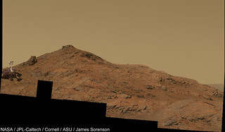
Without Rover
With Rover
Without Rover
This is a "lo-fi" version of our main content. To view the full version with more information, formatting and images, please click here.