Help - Search - Members - Calendar
Full Version: Exploring Murray Ridge
Unmanned Spaceflight.com > Mars & Missions > Past and Future > MER > Opportunity
Pages: 1, 2, 3, 4, 5, 6, 7, 8
fredk
QUOTE (charborob @ Apr 19 2014, 07:05 PM) *
Nice pancam view of Cape Tribulation on sol 3637

Leave town for a week and suddenly it looks like a new mission! Stunning pans everyone.

I don't know exactly where we are but I think we've moved to the SE somewhere into this area on 3639:
Click to view attachment
This is based mainly on a knob on the near eastern horizon getting larger between 3637 and 3639.
Phil Stooke
Got it - here we are, a big drive south. I only have a location, not a route.

Phil

Click to view attachment
fredk
Yep, that looks right. What a long drive!
vikingmars
Trying to find my way as a mountain hiker...

==> Dear Phil here are 2 pics :
- one taken far away at Sol 2295 and showing Murray Ridge : it appears as an elongated hill with 2 distinct summits, the 2nd being the highest :
Click to view attachment
- one taken Sol 3637 with a quick picture interpretation to show where the two summits of Murray Ridge may be located :
Click to view attachment
Correct me if I'm wrong but we are nearing the 1st summit and we need now to travel to the 2nd summit before reaching the best vantage point...
There, we will take the best panoramic pictures with a gorgeous view on the slopes of Cape Tribulation !

Thanks again for your nice maps smile.gif
craigmcg
Seems like the "winter haven" is behind us?
jvandriel
It looks like Opportunity is on the 1st summit on Sol 3641.

Jan van Driel

Click to view attachment
fredk
As Viking's first pic shows, the "first summit" is very broad and flat, but since we can see over it now it does look like we've crested it.

The "second summit" is along the clay signature we're headed for, and with these energy levels we could get there fast...
Phil Stooke
Here's a circular version of the 3641 mini-pan to show where we are, and a map showing the location (I am deliberately not drawing this up as a full map and putting it in the route map thread because I don't want to take over the 'official' Opportunity mapping)

Phil

Click to view attachment

Click to view attachment
Floyd
Hi Phil or any other cartographer--could you post a larger context image of all of Murray Ridge or Murray Ridge and Tribulation (either here or in the map thread). In the map thread I went back a dozen or more pages and could not find a helpful context map. The map of the all of Endurance is too large--sorry to be picky.

Thanks in advance fredk [how did I know fredk would post--must be a time warp]
fredk
This image extends just a bit into Tribulation.
charborob
Sol 3642 navcam pan: clear view of Cape Tribulation.
Click to view attachment
craigmcg
I'm sure this was posted here before, but as we get closer to the big clay signature it seemed worth a second look.

http://www.nasa.gov/mission_pages/mer/mult...y/pia13708.html

Also, one of many papers you get by searching the web for papers on the topic:

http://www.planetary.brown.edu/pdfs/3954.pdf
fredk
Very nice cloud sequence on 3640, eg
http://qt.exploratorium.edu/mars/opportuni...0M1.JPG?sol3640
There are four good cloud images that piece together in pairs (I can't see the two pairs fit together). Definitely an advanced stitching job for our resident experts, considering cloud movement and stretching differences...

On another topic, the tau measurements have plummetted down close to 0.2 recently, which is very low for this (or any) time of year. There's always some potential degeneracy with dust factor which relies on modelling to resolve, but still this is probably as good as it gets for imaging distant features.
Ant103
I'm on it smile.gif

Beautiful clouds there !

Phil Stooke
Latest position and a reprojected pan originally from Charborob.

Phil

Click to view attachment

Click to view attachment
dvandorn
QUOTE (Ant103 @ Apr 23 2014, 11:21 AM) *
Beautiful clouds there !

Yep -- and I believe that the brighter cloud arc to the right of the (not imaged) solar disc may well be a sundog. Looks like a subtle arc forming a portion of a halo around the sun, not directly associated with the cloud structures.

Cool!

-the other Doug (with my shield, not yet upon it)
fredk
Doug - any chance you could point to your arc candidate on an image?
Deimos
fredk: I would bet on tau retroactively jumping up within a week or so. The reported values are quite extraordinary.
dvandorn
QUOTE (fredk @ Apr 23 2014, 01:55 PM) *
Doug - any chance you could point to your arc candidate on an image?

Sure. Here's a piece of the cloud mosaic; the black arrows point to the top and bottom of the arc that I'm seeing. I put a green bracket to the left of the arc I'm seeing, as well.

Now, the thing that makes it look like a sundog to me is that in the middle of the arc, it looks like the cloud structure is unchanged but that it glows more brightly than to the right or left, or even up and down the ring arc a bit. That would be the center of the sundog on the right side of the sun.

I've seen the same kind of thing here on Earth thousands of times, and this looks like the same thing to me...

-the other Doug (with my shield, not yet upon it)

Click to view attachment
djellison
I doubt it's a sun-dog/halo. Those are 22 degrees from the sun usually, and this looks to be at least one NavCam FOV (45 deg) from the sun

Simulations here http://www.atoptics.co.uk/halo/owmars.htm

More likely an internal reflection from the camera
fredk
Should a sundog be at the same elevation as the sun? Your feature appears to be a fair bit higher than the sun - I think most of the horizon in this view is the distant, true western horizon.
dvandorn
OK, kewl. I didn't have a really good way to measure the angular distance from the solar disc. Thanks for that.

smile.gif

-the other Doug (with my shield, not yet upon it)
dvandorn
QUOTE (fredk @ Apr 23 2014, 07:15 PM) *
Should a sundog be at the same elevation as the sun? Your feature appears to be a fair bit higher than the sun - I think most of the horizon in this view is the distant, true western horizon.

Honestly, I was looking at the mosaic and thinking that the solar disc was not imaged, was behind the cut-outs on the upper left side of the mosaic. Looking more closely, it does indeed look like the solar disc is imaged (and completely saturates the pixels around it), rather farther down towards the horizon than I was thinking it should be.

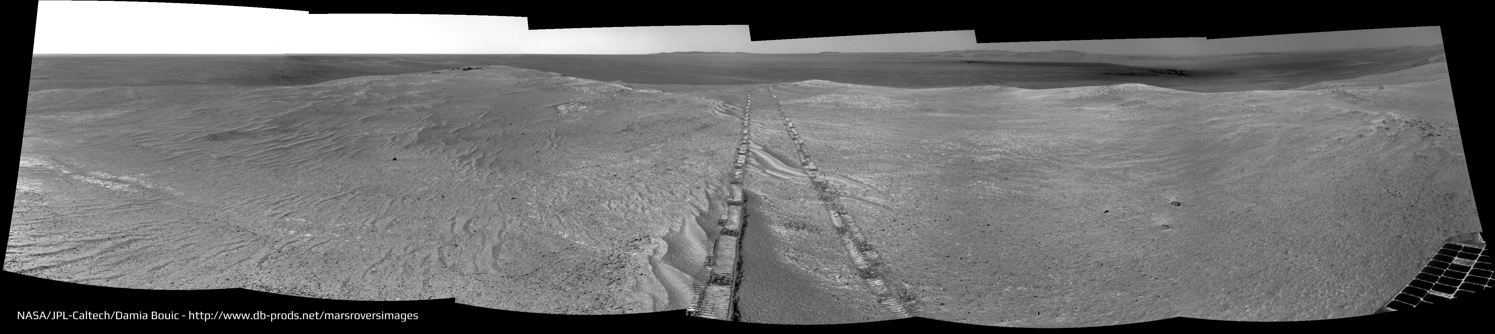
Also, isn't Oppy on a slope? I thought perhaps that what looks like horizontal in the image really isn't because the horizon may not be horizontal where she's sitting. With an undulating horizon from a tilted rover, I wasn't very positive that a different distance above the horizon equated to a different elevation.

Again, though, thanks for the comments, guys. It looked like a sundog to me more because of the way the little arc sort of glowed in mid-arc, which does indeed resemble the sundog phenomenon. Dunno if that's an artifact of the mosaicing process or, as Doug suggested, an internal camera reflection, but it did fool me.

-the other Doug (with my shield, not yet upon it)
Ant103
You have to know that the bright cloud at the center of the image is not really bright, it's an artifact of fusion between frame during the export of the panoramic. It was pretty hard to stitch and to correct the exposure between frames. So the result may not be perfect wink.gif.
jamescanvin
QUOTE (Deimos @ Apr 23 2014, 09:05 PM) *
fredk: I would bet on tau retroactively jumping up within a week or so. The reported values are quite extraordinary.


So if we assume that tau is unlikely to be really as low as 0.2 then does that imply a Pancam cleaning event? pancam.gif smile.gif
fredk
Nice view of a ~100 metre crater out on the plains:
Click to view attachment

I'm surprized we're not seeing Bopolu/Miyamoto rims, considering the low tau and our elevation above the plains. They should be roughly towards the southwest. Maybe there's a subtle ridge to the SW that's blocking our view now, but didn't back in the early sol-2000's when we could see them clearly.
Phil Stooke
A circular fragment of a pan for 3643.

Phil

Click to view attachment
ngunn
QUOTE (fredk @ Apr 24 2014, 04:12 PM) *
I'm surprized we're not seeing Bopolu/Miyamoto rims, considering the low tau and our elevation above the plains. They should be roughly towards the southwest. Maybe there's a subtle ridge to the SW that's blocking our view now, but didn't back in the early sol-2000's when we could see them clearly.


I don't think we are that high actually, certainly not as high as when those features were last visible. Here is the link back to Peter Grindrod's contour map: http://www.unmannedspaceflight.com/index.p...st&p=156005. Incidentally I wonder if you can either confirm or improve on my tentative IDs of horizon features in posts 84-96 (the week you were away)?
jvandriel
The Navcam L0 view on Sol 3643.

Jan van Driel

Click to view attachment
Phil Stooke
The new location on sol 3643. I call one crater X15, but I don't know which one it really is. This one is surrounded by blocks. Maybe it's really the more distant one indicated by Fredk. When I know I will fix the map if necessary.

Phil

Click to view attachment
atomoid
nice crater view on sol3643, I don't see x15 in any3643 pancams but it may be the big smudge in this sol3462 navcam before checking out the trampled ripples..
Click to view attachment Click to view attachment
jamescanvin
QUOTE (Phil Stooke @ Apr 24 2014, 08:36 PM) *
The new location on sol 3643. I call one crater X15, but I don't know which one it really is.


I think you are right Phil. Based on the pointing data I beleve it's the blocky nearby one.
Phil Stooke
Here's a circular pan view of the 3644 location - between the two little craters on a north-south line on the map. The southern crater is seen in this view.

Phil

Click to view attachment

PS I'm in Salisbury for a family visit - not too far from you, James!


jvandriel
The Sol 3644 Navcam L0 view.

Jan van Driel

Click to view attachment
fredk
QUOTE (ngunn @ Apr 24 2014, 07:03 PM) *
I don't think we are that high actually, certainly not as high as when those features were last visible. Here is the link back to Peter Grindrod's contour map: http://www.unmannedspaceflight.com/index.p...st&p=156005. Incidentally I wonder if you can either confirm or improve on my tentative IDs of horizon features in posts 84-96 (the week you were away)?

I think you're right - some higher-resolution contour plots in this thread show better that we're still not as high as we were back around the early sol 2000's. We may need to get a substantial ways up Tribulation before we'll see features like Miyamoto/Bopolu.

About the feature on the SW horizon, I'm skeptical that it's the suggested crater ("A" in my image below), even though the diameter seems to fit as you pointed out. On 3643, the feature lined up with the right side of the much closer ~100 metre crater I posted about above, "D". Sighting along the right edge of "D" takes us well south of "A", see lower line here:
Click to view attachment
Crater "A" should appear well to the right of "D", see upper line. Crater "B" is another possibility. But I think the horizon feature is actually the much closer crater "C". It lines up nicely with "D" and is on a subtle ridge according to the contour plots and has the right width to match the horizon feature.
ngunn
Nice work on the horizon feature and thanks for taking the trouble. There are only a few of us mad enough to care about such a small blip laugh.gif but I do like knowing how far away the horizon is! Quite close seems to be the answer. It should be easy to confirm your identification by the change in bearing as we move south.
jvandriel
Here is the complete 360 degree Navcam L0 panoramic view from Sol 3639.

Jan van Driel

Click to view attachment
fredk
One more crater ID - what appears to be a cluster of craters:
Click to view attachment
is 21 degrees right of the left rim of crater "C", matching the cluster labelled "E":
Click to view attachment
The cluster may appear to be closer than "C", but I think that's just because we can see a much more distant ridge behind "E" that's not visible behind "C".
charborob
Sol 3644 pancam view of Lunokhod2 crater:
Click to view attachment
jamescanvin
Here is the full L456 mosaic of Lunokhod 2 Crater (it's been a long time since I've done this, I'm rather out of practice!)
Phil Stooke
70 m drive on sol 3649 - here's a circular mini-pan (Navcams supplemented by one pancam)

Phil

Click to view attachment

and the approximate location:

Click to view attachment
ngunn
QUOTE (jamescanvin @ Apr 30 2014, 12:02 AM) *
Lunokhod 2 Crater (it's been a long time since I've done this


I hope it's just the first of many more to come. smile.gif

Anybody know why the Lunokhod 2 name was chosen for this crater? Is it related in any way to odometry?
Phil Stooke
Not to breaking the record specifically. Lunokhod 1 is just a short distance further north. My estimate is that there is about 3 km to go before a record can be claimed.

Phil

Phil Stooke
Quick circular pan - or a quarter of a pan anyway. I'm having trouble finding an exact location with such a small area.

EDIT - two more pics, now I can locate it. I replaced the earlier image with a larger circular pan, and here's the location.

Phil

Click to view attachment

Click to view attachment
atomoid
interesting MER update summary on planetery.org . Now I want a 3D printer..
mhoward
There is a May 2 update at Field Notes from Mars (nmnaturalhistory.org) that has a nice oblique drive map, showing the path right up to the Al-OH area just ahead, and looking beyond to 'smectite valley' (probably not an official name).

The Sol 3650 Pancam drive direction images look intriguing.
fredk
Yeah, and that field notes blog says:
QUOTE
WE hope to go another 2.5 km south in this field season to the placed labeled “smectite valley”.
I'm not sure what "field season" means, but that's a long drive. "Smectite valley" is well up Tribulation.

And the planetary update had this interesting bit about the cleaning events:
QUOTE
"Being on the rim of Endeavour Crater, we've seen that we're cleaner when we're on the windward side of Murray Ridge as opposed to the leeward side," said Seibert. "So, we have a hunch that when we need more cleaning next winter, we may be able to intentionally design where we explore and take Opportunity."
Ant103
Some Navcam panorama I wanted to stitch, just for the beauty of the site smile.gif

Sol 3643


Sol 3649. Notice the pretty clean solar panels smile.gif


Phil Stooke
Great pans - and now we have new pictures from 3653, and we are on the rocks. Beautiful. Here's a quick circular view. I want to see a bit more before mapping a location.

The orientation is not correct (north-up), but I will fix it when I have more to go on.

Phil

Click to view attachment
charborob
Sol 3653 navcam pan:
Click to view attachment
This is a "lo-fi" version of our main content. To view the full version with more information, formatting and images, please click here.
Invision Power Board © 2001-2024 Invision Power Services, Inc.