Full Version: Exploring Murray Ridge
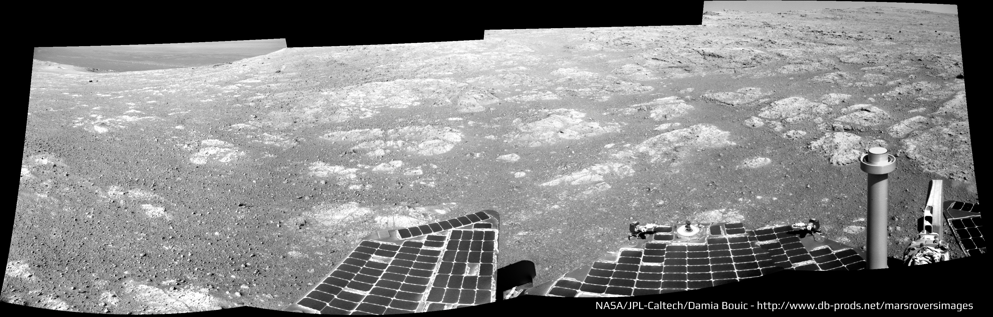
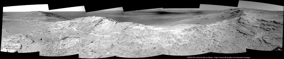
Sol 3653 Navcan panoramic.

WOW ! Thanks Phil, Charborob and Damia !
"Yum - yum" for all those rocks : this is all I can say !
This is indeed a brand new mission and it was worth the trip
"Yum - yum" for all those rocks : this is all I can say !
This is indeed a brand new mission and it was worth the trip
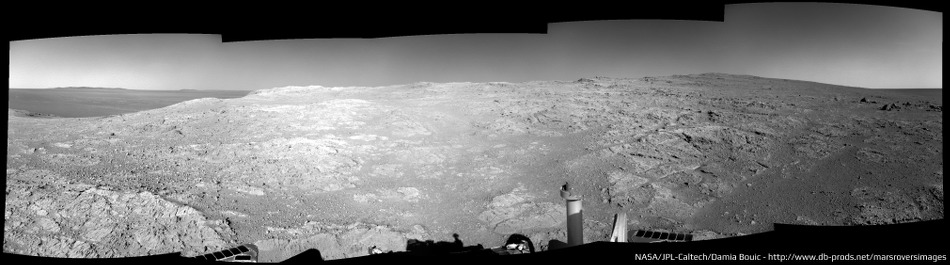
Sol 3654 navcam pan:
Click to view attachment
Click to view attachment
My version. Opportunity Right Navcam Sol 3654
Increased slightly contrast to better see the details a little cleaning and denoise.

Click on image for full size
And polar projection
Click to view attachment
Click on image for full size
Increased slightly contrast to better see the details a little cleaning and denoise.
Click on image for full size
And polar projection
Click to view attachment
Click on image for full size
The half-pans over the last two sols fit together to make a full one - here's a circular version giving a really clear view of where we are right now.
Phil
Click to view attachment
Phil
Click to view attachment
From my previous panorama, I tried to make a simulated composition including a 3D model of the rover. The orientation is not faithful. The rover size is based on the distance and spacing of the footprints in the ground for the placement of the vehicle and give an idea of the approximate scale in the context of the image. I also added a backlight to give a touch of drama to the image.
The post is not intended to be exactly realistic. It is only a test.
Anyway, I think it has been well enough to share it in the forum. Hope you like it.

Click on image for full size or this link
The post is not intended to be exactly realistic. It is only a test.
Anyway, I think it has been well enough to share it in the forum. Hope you like it.
Click on image for full size or this link
Nicely done Dig!
Did you make the 3D rover model if I may ask?
Did you make the 3D rover model if I may ask?
The Navcam images taken on Sol 3653 and Sol 3654 stitched together.
Jan van Driel
Click to view attachment
Jan van Driel
Click to view attachment
QUOTE (James Sorenson @ May 7 2014, 10:05 AM) 
Nicely done Dig!
Did you make the 3D rover model if I may ask?
Did you make the 3D rover model if I may ask?
Thank you James.
Regarding the 3D model, it is not mine. I searched and found one free. Not much detail, but enough for what I needed. You can find it here.
Mars Rover Spirit Opportunity
Regards
It looks like a sunset ND sequence:
http://qt.exploratorium.edu/mars/opportuni...8M1.JPG?sol3654
http://qt.exploratorium.edu/mars/opportuni...8M1.JPG?sol3654
http://qt.exploratorium.edu/mars/opportuni...8M1.JPG?sol3654
http://qt.exploratorium.edu/mars/opportuni...8M1.JPG?sol3654
My take  There is some clouds to the right part of the panoramic :
There is some clouds to the right part of the panoramic :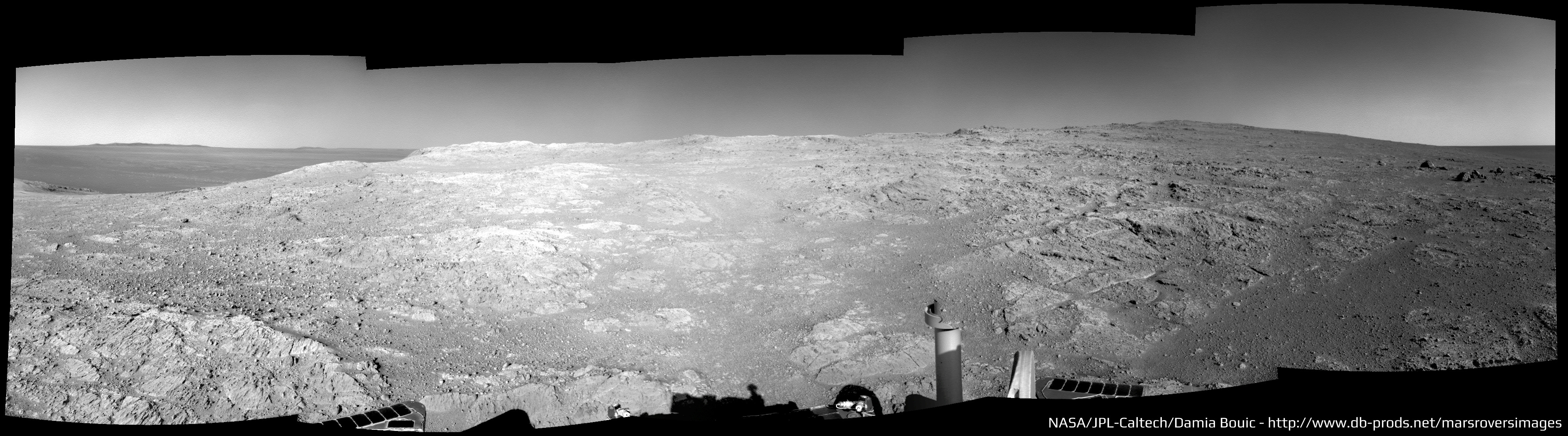
Sol 3658 r-pancam filter 2:
Click to view attachment
Click to view attachment
QUOTE (charborob @ May 9 2014, 09:43 PM)
Sol 3658 r-pancam filter 2:
Thanks a lot Charborob, this is an incredible landscape !
Sol 3659 navcam pan:
Click to view attachment
(Panorama is a bit crappy, but the scenery is fantastic.)
Click to view attachment
(Panorama is a bit crappy, but the scenery is fantastic.)
Yes indeed, fantastic. I added the partial frame at the right end of your pan and made a circular version of it. Some little veins cutting the rock here and there. Also - where I think we are now.
Phil
Click to view attachment
Click to view attachment
Phil
Click to view attachment
Click to view attachment
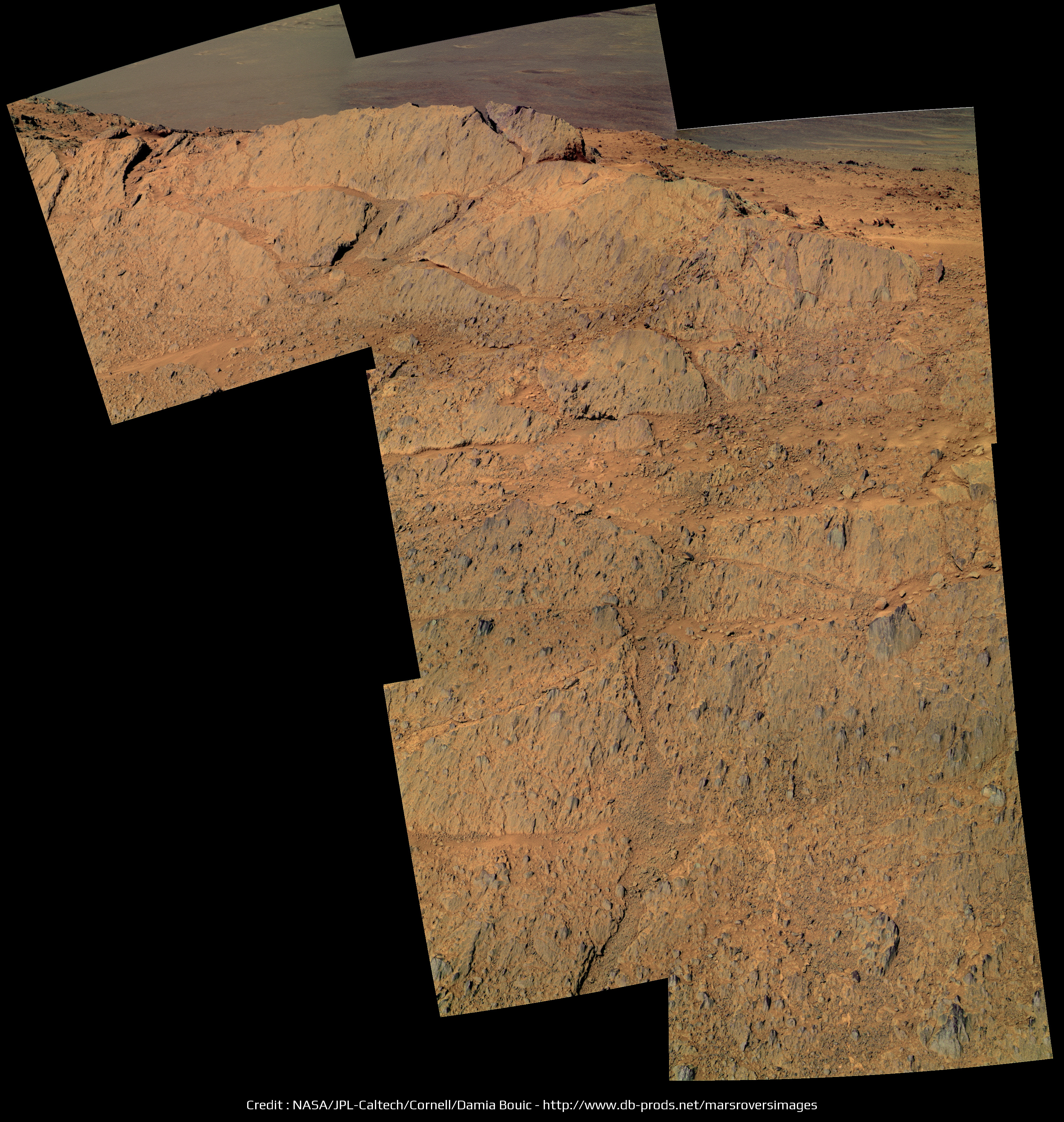
More than just about anywhere else here at Meridiani (or even at Gusev or Gale), this area looks like it was a heavily populated block field which has been worn down to just the nubs of boulders after eons of wind erosion.
This appears to go beyond Steve Squyres' "dog's breakfast" of eroded, jumbled rocks. This area was a huge GIANT dog's breakfast...
-the other Doug (with my shield, not yet upon it)
This appears to go beyond Steve Squyres' "dog's breakfast" of eroded, jumbled rocks. This area was a huge GIANT dog's breakfast...
-the other Doug (with my shield, not yet upon it)
My take on this pan, it's a wonderful view

UPDATED
UPDATED
QUOTE (dvandorn @ May 11 2014, 07:34 AM)
...this area looks like it was a heavily populated block field...
To me it looks like fairly intact layers uplifted as a crater rim during impact.
Indeed they do, although if this is uplift rim it is a little difficult to correlate to the contention that at the much lower Cape York Matijevic Formation, the contact represented the pre impact surface. Could we possibly be looking at an overturned rim here being the pre-Endeavour sub surface?
The view is superb and I love the contrast between the fall away into the crater to the East compared to the gentle Western slope of the Meridiani onlap.
The view is superb and I love the contrast between the fall away into the crater to the East compared to the gentle Western slope of the Meridiani onlap.
QUOTE (Ant103 @ May 11 2014, 03:02 PM)
My take on this pan, it's a wonderful view
Great! Damia
QUOTE (serpens @ May 12 2014, 12:13 AM)
if this is uplift rim it is a little difficult to correlate to the contention that at the much lower Cape York Matijevic Formation, the contact represented the pre impact surface.
Are we all that much higher in fact? Even if we are a little higher I don't see much of a problem. We can't assume the pre-Endeavour surface was horizontal to start with, or that different portions of the rim were necessarily uplifted by equal amounts.
Yes, a beautiful place, and that new full panorama is spectacular, Damia. Here's a circular version.
To me these rocks look like the impact breccias (AKA ejecta) on Cape York. There are lots of clasts embedded in the rocks right in front of us.
Phil
Click to view attachment
To me these rocks look like the impact breccias (AKA ejecta) on Cape York. There are lots of clasts embedded in the rocks right in front of us.
Phil
Click to view attachment
NPREVs point that the height difference is not all that great is well taken, however as Phil points out this is a clastic breccia, akin to the Cape York Shoemaker formation whereas the Matejevik original surface was fine grained. My query about potential overturned rim was prompted by a niggling question as to whether, given the low solubility of aluminium, there would be sufficient groundwater in the rim to enable aluminium hydroxide to form. If not then this could imply a pre-impact formation.
QUOTE (Phil Stooke @ May 12 2014, 03:51 PM)
To me these rocks look like the impact breccias (AKA ejecta) on Cape York. There are lots of clasts embedded in the rocks right in front of us.
Yep, that's exactly why it looks to me like this used to be a blocky ejecta field that has been eroded down to the ground, so to speak. Because the base rocks all appear to be highly brecciated.
I appreciate the comments, though -- to let a small cat out of the bag, I'm in the middle of a very difficult recovery from the first of two major abdominal surgeries. (The second surgery will happen as soon as I'm well enough recovered from the first one, and I keep developing post-op infections that are getting badly in the way of my recovery). This means that I have had more time and such to read and post to the forum -- but it also means that, at least at times, I'm on some pretty serious painkillers. I check anything I post three or four times to make certain it's not the product of a drug-addled brain, but just to let y'all know, if I post something that seems more incoherent than normal for me, it's likely because of the ocycodone.
But anyway, thanks Phil, I'm happy to see that I'm not the only person who noticed that the base rocks here at Murray Ridge all seem to be breccias, implying this is the remnants of a thickly bouldered ejecta field.
-the other Doug (with my shield, not yet upon it)
Doug--It is a real fight sometimes. Keep your shield up and know we are shoulder to shoulder with you.
Regards, Floyd
Regards, Floyd
Sol 3633 & 3634 pancam panoramic, now in colors


QUOTE (Ant103 @ May 13 2014, 01:00 PM)
Sol 3633 & 3634 pancam panoramic, now in colors
How nice ! Thanks a lot Damia
Beautiful Damia. The view from a height, combined with a bit of colour really helps put the crater and the encroachment of the sulphate sandstone into perspective. Cape York looked quite impressive from orbital images and towered over the landscape in initial DEM presented in this forum, but were it not for the bench one could easily overlook it in the panorama.
QUOTE (Ant103 @ May 13 2014, 01:00 PM)
It is impressive how clearly we can see now in this panorama (more to the right) the ejecta and rim of Iazu crater. Even a the cliff-like feature at the northern edge of the ejecta blanket is visible. Furthermore, it appears its rim is pretty "spiky".
The atmosphere seems to be very clear at the moment, so maybe we can see even more distant features if opportunity reaches the top of Endeavour's rim ...
Thanks
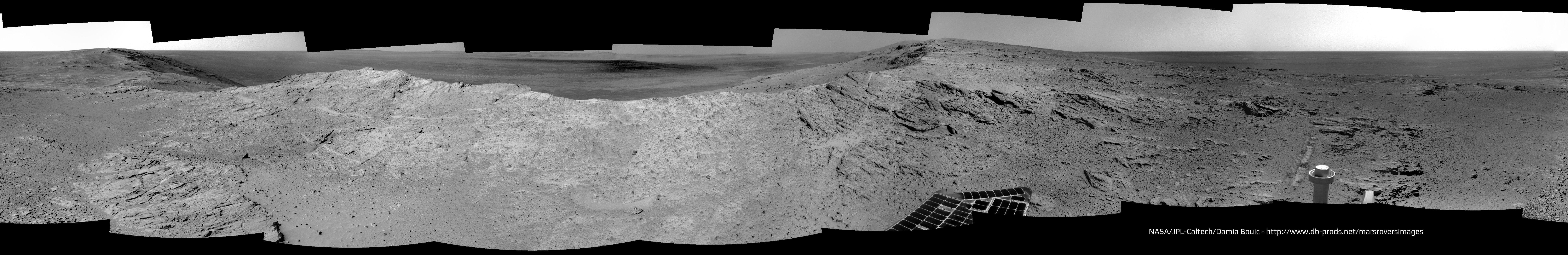
Sol 3662 Navcam panoramic. A very neat place
Sol 3662 Navcam panoramic. A very neat place

Phil checking in from Heathrow on my way to Washington ...
Fantastic views from up here! The view north to Cape York in the Pancam mosaic is the best yet, and gives us the best view ever of the subdued crater north of Cape York, known as Antares, even showing dunes on its floor. I won't show it here as I'm a bit limited in what I can do right now.
Phil
Fantastic views from up here! The view north to Cape York in the Pancam mosaic is the best yet, and gives us the best view ever of the subdued crater north of Cape York, known as Antares, even showing dunes on its floor. I won't show it here as I'm a bit limited in what I can do right now.
Phil
There are some large boulders down in the main crater floor below the far rim. I can't get a real sense of their scale from just gawking. Anyone have an idea just how big they are?
Sol 3663 pancam of the outcrops at the crest.

QUOTE (Art Martin @ May 14 2014, 07:09 AM)
There are some large boulders down in the main crater floor below the far rim. I can't get a real sense of their scale from just gawking. Anyone have an idea just how big they are?
At 22Km, each PANCAM pixel is about 5.25 meters tall/wide.
Paolo
This location has been named Pillinger Point in the descriptions of the latest Pancam images. Nice!
Phil
Phil
In this image there is a bright smudge near the horizon directly above the rightmost end of Cape York. I don't see it in images from a few days ago:
http://qt.exploratorium.edu/mars/opportuni...AHP0783L0M1.JPG
http://qt.exploratorium.edu/mars/opportuni...AHP0783L0M1.JPG
Good eye. It does look like a gust.
QUOTE (Phil Stooke @ May 17 2014, 05:21 AM)
This location has been named Pillinger Point in the descriptions of the latest Pancam images. Nice!
Phil
Phil
For those who may have missed the reference, Colin Pillinger was the colorful principal investigator for the Beagle 2 mission. He died on May 7th.
QUOTE (Art Martin @ May 14 2014, 05:09 PM)
There are some large boulders down in the main crater floor below the far rim. I can't get a real sense of their scale from just gawking. Anyone have an idea just how big they are?
These objects look very interesting! But do these boulder-like features have to be allochthonuous necessarily? Maybe they are old remnants of a sedimentary layer that once covered the crater floor. These objects are very big and located pretty far from the steep slope of the crater rim. I am not sure if they could have moved so far on a relatively even surface. Furthermore, we can see in CTX datasets in the southwestern part of the crater floor a little cliff-like feature of a sedimentary layer that has to be autochthonuous. It is in close proximity to these boulders.
So these boulders might be some knobs of a former sedimentary layer?
QUOTE (Eutectic @ May 18 2014, 11:51 PM)
For those who may have missed the reference, Colin Pillinger was the colorful principal investigator for the Beagle 2 mission. He died on May 7th.
Oh crumbs he died....
My identification of the large blocks we're seeing now:
Click to view attachment
Click to view attachment
Good identification, fredk, and I would refine it slightly based on some reprojections I played with, to these hills.
Phil
Click to view attachment
Phil
Click to view attachment
This is incredible - 761 Whrs and dust factor 0.964! From the latest update.
Wow!
This is a "lo-fi" version of our main content. To view the full version with more information, formatting and images, please click here.