Time for a new thread... we should be starting up right about now after conjunction, and if no other targets have popped up our plucky rover should be heading south within days. This should be quite a scenic trip, so sit back and enjoy the fun.
Phil
Full Version: Heading south from Cape York
Good timing, Phil - the first post-conjuction pics are coming in now:
http://qt.exploratorium.edu/mars/opportuni...8M1.JPG?sol3285
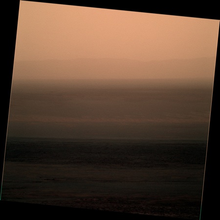
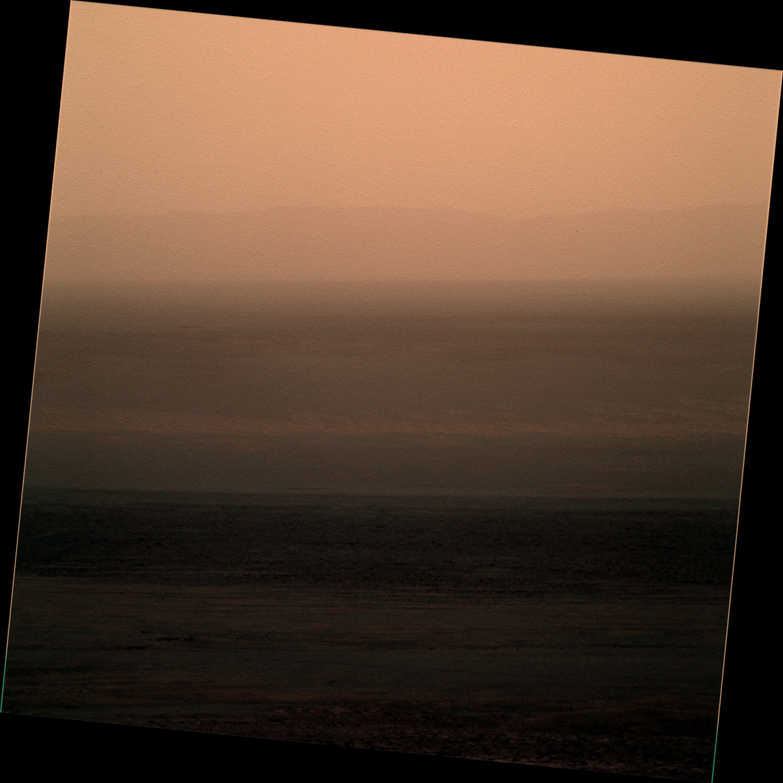
Now we know the sun's still shining on Mars!
http://qt.exploratorium.edu/mars/opportuni...8M1.JPG?sol3285
Now we know the sun's still shining on Mars!
Technically we haven't seen any images from the last 6 sols or so yet, but I'm going to take a leap of faith and assume those will be coming soon.
Opportunity in Standby as Commanding Moratorium Ends
Adding: @mikeseibert on Twitter says "Oppy should be back to regular operations after tomorrow's uplink. #knockonwood" So let's knock on wood.
Adding: @mikeseibert on Twitter says "Oppy should be back to regular operations after tomorrow's uplink. #knockonwood" So let's knock on wood.
If that's the case I'm off to listen to Tony Orlando...
QUOTE (mhoward @ Apr 30 2013, 01:19 AM) 
Adding: @mikeseibert on Twitter says "Oppy should be back to regular operations after tomorrow's uplink. #knockonwood" So let's knock on wood.
And look what's included on "tomorrow's uplink".

03294::p1154::01::2::0::0::2::0::4::front_hazcam_idd_unstow_doc
03294::p1165::00::1::1::0::0::0::2::flhaz_IDD_check_subframe_2bpp_pri_41
03294::p1201::07::2::0::0::2::0::4::front_haz_penultimate_1bpp_pri17
03294::p1214::05::2::0::0::2::0::4::front_haz_ultimate_4bpp_pri15
03294::p1234::06::2::2::0::0::0::4::front_haz_fault_half_pri15_4bpp
03294::p1254::02::2::0::0::2::0::4::front_haz_fault_pri15_4bpp
03294::p1301::06::2::0::0::2::0::4::rear_haz_penultimate_1bpp_pri17
03294::p1334::00::2::2::0::0::0::4::rear_haz_fault_half_pri15_4bpp
03294::p1354::01::2::0::0::2::0::4::rear_haz_fault_pri15_4bpp
03294::p1939::05::2::0::0::2::0::4::navcam_idd_doc_1_bpp_pri_15
03294::p1960::05::2::0::0::2::0::4::nav_1x1_az0_El_neg50_4bpp_pri16
03294::p2601::05::4::2::0::0::2::8::pancam_tau_L78R48

As they say on the Internet: "Squee!"
QUOTE (Tesheiner @ Apr 30 2013, 12:40 AM)
...
Actually it will be a teeny tiny drive. In fact it will be my shortest drive ever. So short we had to devise a trick to actually command such a small motion by combining two slightly larger ones. But at least it is
Paolo
Oh well, any is good
is good
So is Oppy up and running, or was that premature optimism and they're still trying to regain control?
tl;dr - or
or  ?
?
tl;dr -
or ?
I don't think there is any reason to be worried at this point.
I know we're all in withdrawal but hang in there folks, I'm sure we'll get our fix soon.
I know we're all in withdrawal but hang in there folks, I'm sure we'll get our fix soon.
The article has been updated today to confirm that Opportunity has resumed normal operations.
(Still waiting for new images though.)

QUOTE
NASA's Mars Exploration Rover Project received confirmation from Mars this morning (May 1) that the Opportunity rover is back under ground control, executing a sequence of commands sent by the rover team. Opportunity is no longer in standby automode and has resumed normal operations.
(Still waiting for new images though.)
Our beloved Rover Driver was featured in a bbc article today
From the latest PS update, some more details about plans:
QUOTE
Once Opportunity does leave Matijevic Hill, the plan is for the rover to put her pedal to the metal and drive straight for Solander Point. "We calculated a rapid transit route through the winter strategy planning group, a straight-forward engineering route that would get us to Solander Point in time," Arvidson informed. "The issue is, if we leave in say mid-May roughly, there's just not a whole lot of time to do diversions to scientifically interesting locations. This route allows for a short stop at Nobby's Head so that the rover can take some stereo images of the northern side of hill for engineering characterization of slopes, just in case we need a possible bail-out location for winter, but other than that it's a path that will take Opportunity to Solander as quickly as possible. It's equivalent to what we're doing on Curiosity to get that rover to Mt. Sharp."
And, per the more immediate plan, Opportunity bumped slightly to the right today (3296). Lots of good info in the Update, as usual.
Tau has jumped a lot in the past week or so, from around the 0.7 level where it's been for a long time up to 1.5 on 3301, as Lemmon's page shows. This is the highest it's been this Martian year, although as you can see from the chart, we've had very similar jumps at the same solar longitude in previous years. So hopefully it will drop back down quickly (within a couple of weeks), as it has in the past.
The increased dust is very obvious in both the lightness of the shadows and the haziness of the far rim of Endeavour by comparing these views from 3296 and 3301:
http://qt.exploratorium.edu/mars/opportuni...0M1.JPG?sol3296
http://qt.exploratorium.edu/mars/opportuni...0M1.JPG?sol3301
The increased dust is very obvious in both the lightness of the shadows and the haziness of the far rim of Endeavour by comparing these views from 3296 and 3301:
http://qt.exploratorium.edu/mars/opportuni...0M1.JPG?sol3296
http://qt.exploratorium.edu/mars/opportuni...0M1.JPG?sol3301
I was reading again the current PS update this morning. If the plan is still the same, the above FHAZ image may be one of the last ones from this site.
QUOTE
The idea is to bump to this new Esperance target, to offset a little bit, RAT it if we can, take some MI pictures and look at it with the APXS, and then get moving towards Solander Point as quickly as possible.
From the MRO forecast:
QUOTE
...a large regional dust storm developed along the Acidalia-Chryse storm-track last week... Although the dust storm passed well to the west of the Opportunity rover in Meridiani, elevated levels of atmospheric dust are expected over the rover site in the coming week as suspended residual particulates in the atmosphere are transported eastward by the southern tropical circulation... skies above the Curiousity rover site in Gale crater remained relatively clear and storm-free.
Here's an MI mosaic from the images taken during sol 3301.
Click to view attachment
Now I understand Squyres' comment to TPS: Esperance, however, is a difficult target to say the least. "This vein is just about as nasty a RAT target as you can imagine," said Squyres. "It's irregular, tiny, and has newberries surrounding it which complicate the task."
Click to view attachment
Now I understand Squyres' comment to TPS: Esperance, however, is a difficult target to say the least. "This vein is just about as nasty a RAT target as you can imagine," said Squyres. "It's irregular, tiny, and has newberries surrounding it which complicate the task."
thanks for the nice mosaic, for a second it carried me back to the other thread looking at an orbital view of Gale..!
Yeah!!
Looking at the "telemetry" I read something like 24m due south. A proper map update will have to wait 'til tomorrow when I'm back home.
Looking at the "telemetry" I read something like 24m due south. A proper map update will have to wait 'til tomorrow when I'm back home.
We hit the road, Jake!
(thanks for everything)
(thanks for everything)
And a further 80m tosol (3309)
So, we're now about 140 mere meters from Apollo 17th rover record. I'll expect Oppy will be n°2 quite soon, still 1.1 km short to pass Lunakhod 2. GoOppy, go
http://en.wikipedia.org/wiki/Lunokhod_2
The Lunokhod 2 achieved its distance record in about 6 months.
Contributing to this, the top speed of the rover was about 1.2 MPH compared to the MER and MSL rover speeds of about 0.1 MPH.
Opportunity may break the distance record, but I think it will be some time before the speed record is broken!
The Lunokhod 2 achieved its distance record in about 6 months.
Contributing to this, the top speed of the rover was about 1.2 MPH compared to the MER and MSL rover speeds of about 0.1 MPH.
Opportunity may break the distance record, but I think it will be some time before the speed record is broken!
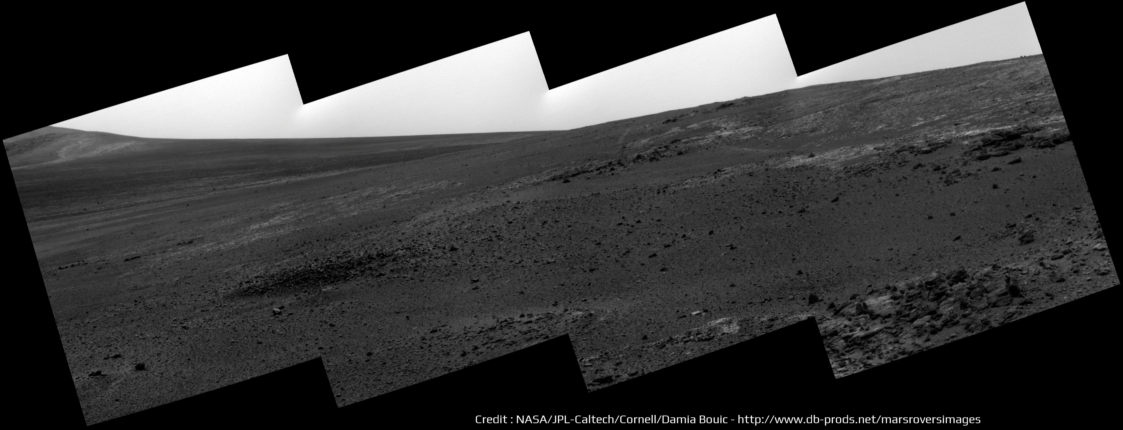
The beginning of a new journey is for me the occasion to going back to some imagery That was a long time not stitching and coloring these picture from our old little girl .
Sol 3303 - Dusty atmosphere this sol :
And a last Navcam pan before the move :
(And also, a new gallery with a timeline, just like Curiosity http://www.db-prods.net/marsroversimages/o...unity-2013.html )
That was a long time not stitching and coloring these picture from our old little girl .Sol 3303 - Dusty atmosphere this sol :
And a last Navcam pan before the move :
(And also, a new gallery with a timeline, just like Curiosity http://www.db-prods.net/marsroversimages/o...unity-2013.html )
QUOTE (climber @ May 16 2013, 09:10 AM)
So, we're now about 140 mere meters from Apollo 17th rover record. I'll expect Oppy will be n°2 quite soon, still 1.1 km short to pass Lunakhod 2. GoOppy, go
JPL has made it official:
"The team operating NASA's Mars Exploration Rover Opportunity received confirmation in a transmission from Mars today that the rover drove 263 feet (80 meters) on Thursday, bringing Opportunity's total odometry since landing on Mars in January 2004 to 22.220 statute miles (35.760 kilometers)."
Nine-Year-Old Mars Rover Passes 40-Year-Old Record
Hey, I think it so cool that Gene Cernan is talking to the MER Team about this.
And it looks like the Lunakhod 2 record is not far from being broken. Go Oppy!
Ron
And ~95m more tosol (3310)
Quick look at some features just ahead in a stretched view of the Navcam frame.
Phil
Click to view attachment
Phil
Click to view attachment
James tweeted: "Oppy sol 3310 - Took pancam images of Karratha & Corunna Downs. Then drove 95m SW along Cape York. "
Do we know yet which features these are?
Phil
(always hungry for feature names)
Do we know yet which features these are?
Phil
(always hungry for feature names)
Looks like there's another drive coming up for sol 3312.
QUOTE (Phil Stooke @ May 17 2013, 07:25 PM)
Do we know yet which features these are?
We haven't seen many images come down yet, so it's hard to be sure. Here's my estimate based on what we do have, though. This is seen from site 170/0114 (sol 3308), below "Kirkwood".
I hope we'll see some more images soon, so I can find out if I was right! (And so we can have some more images.)
Edit: Oops, mispelled "Corunna" in the image. Lack of coffee, etc.
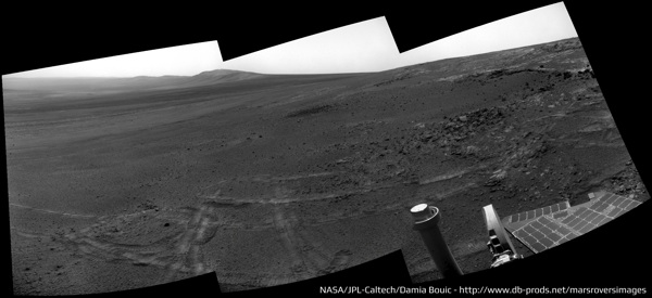
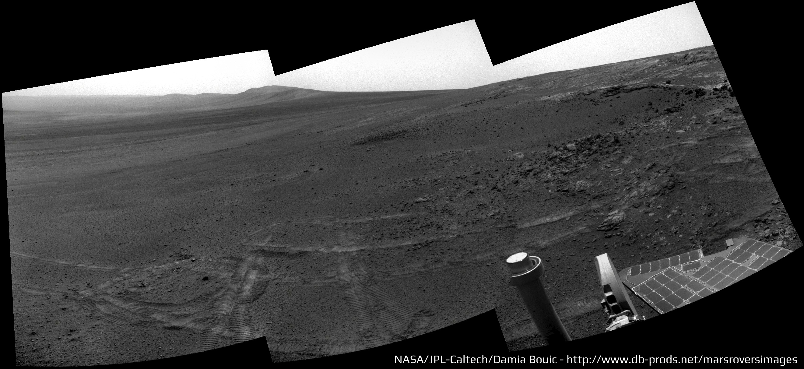
Sol 3308 panoramic updated :
And the Pancam drive direction

And the Pancam drive direction
Thanks, Ant. Isn't it great to see drive-direction pancams again?
Based on the drives so far, it looks like the plan may be to hug the "coast" of CY, just inland, rather than driving straight for Solander Point.
Based on the drives so far, it looks like the plan may be to hug the "coast" of CY, just inland, rather than driving straight for Solander Point.
Actually, I'm wondering if she will do a quick stop near Odissey to image those old tracks around it.
According to the last Planetary Society MER update:
"We calculated a rapid transit... " Arvidson informed. "....This route allows for a short stop at Nobby's Head so that the rover can take some stereo images of the northern side of hill for engineering characterization of slopes, just in case we need a possible bail-out location for winter, but other than that it's a path that will take Opportunity to Solander as quickly as possible..."
Illustrated in the March 1, 2013 entry here:
Click to view attachment
Just bck to Opportunity's driving record, there's a nice little poster on vehicle driving distances (Moon and Mars) over on i09.
http://io9.com/the-records-for-the-greates...ars-a-508328297
Back to the drive south
http://io9.com/the-records-for-the-greates...ars-a-508328297
Back to the drive south
QUOTE (centsworth_II @ May 19 2013, 10:01 AM)
Illustrated in the March 1, 2013 entry here:
Wow, thanks Centsworth - I wasn't aware of that site. Looks like a good source for geo maps, place names, etc.QUOTE (Astro0 @ May 19 2013, 01:58 PM)
there's a nice little poster on vehicle driving distances (Moon and Mars) over on i09.
That's from a full press release.
This looks like a good place to add a note of caution about Lunokhod driving distances. They will have to be recalculated based on the LROC images. When the actual Lunokhod 2 tracks are compared with the original Soviet-era map, it looks to me like they landed slightly north of the expected location, drove a bit further south than they thought, then east, and finally ended up further north than they thought. Some extra distance will probably come out of a recalibration of the drives (maybe they allowed for more wheel slip than actually occurred). A new mapping effort is under way at MIIGAiK - they already did Lunokhod 1 and are working on Lunokhod 2. Maybe by LPSC next year we will have a result. Just a caution - we might break the record and then have to break it again!
Phil
Phil
Don't just read that great site by Larry Crumpler - those images, especially the maps, can stand a considerable amount of enlargement. Lots of good stuff! Too bad there doesn't seem to be an archive of past reports like these.
Phil
Phil
Did you also notice that we (I on the Spirit & Oppy Statistics) used to get 35890 for Apollo 17 rover and this is also used on the New Mexico Museum's but Nasa says 35744...and tthey can't be wrong 
Phil, do you think all Moon driving distances will have to be reevaluated?
Thanks
Phil, do you think all Moon driving distances will have to be reevaluated?
Thanks
Apollo should be much better than Lunokhod because they had high resolution orbital images and lots of backup position data. I would not have expected much change for Apollo distances. I will look into the difference in those numbers.
Phil
Phil
QUOTE (Phil Stooke @ May 19 2013, 06:39 PM)
Similar distance as on the previous one: 95m. One more drive and we may be reaching the 36km mark.
QUOTE (climber @ May 19 2013, 05:17 PM)
Did you also notice that we (I on the Spirit & Oppy Statistics) used to get 35890 for Apollo 17 rover and this is also used on the New Mexico Museum's but Nasa says 35744...and tthey can't be wrong.
Phil, do you think all Moon driving distances will have to be reevaluated?
Phil, do you think all Moon driving distances will have to be reevaluated?
Did they zero the odometer before deployment or did it still have acceptance test distance logged, compensated for in the distance / direction from start point software? ie. The distance on moon will be less than the total recorded? Comparing the Apollo rovers to the MER is really a chalk and cheese approach and the outcomes depend on how you squint when assessing. For example: if you look at distance and time deployed the Apollo 15 rover is the champ. 0.152 kilometers per minute. Apollo 17 comes in second at 0.135. Opportunity can go down in history as the slowest ever rover in terms of distance /time.

Yes, they zeroed the nav system several times during the EVAs. And the system only told you the range and bearing back to the LM. Total odometry was calculable from this (it was calculated on wheel turns), but was considered somewhat of a "dead reckoning" system. Wheel slippage and meander to avoid rocks and craters meant that the nav system would get you back to where you could see the LM and drive back to it by eye. No one ever pretended that it could tell you within a few meters *exactly* where you were or how far you had driven.
On the LRV, the range and bearing were more often used in finding the planned station stops, and due to the various small detours and wheel slips these readings usually varied from the pre-mission calculated values, even when the slight variations in landing point were taken into account.
All this is to say that you'd have to do the kind of detailed wheel-track analysis they're now doing with the Lunakhods to get the absolute exact distance traveled by any of the LRVs. There is a "wander factor" in the LRV nav data that makes all calculations based on them somewhat approximate.
-the other Doug
QUOTE (serpens @ May 19 2013, 04:13 PM)
Opportunity can go down in history as the slowest ever rover in terms of distance /time.
You could make up a million different statistics all pretty much as meaningless as the next. Distance travelled vs average distance from earth. Distance travelled per KG of vehicle mass. Number of individual drives. Number of locations visited. Total longevity etc etc etc
Interesting stats would be long distance targets like Endurance or Victoria or Endeavor and what was the average drive length when heading towards these goals. Before embarking on the trek to Endeavor folks were doing some math about how long it would take.
btw, didn't we have a pool guessing the arrival date at Endeavor?
btw, didn't we have a pool guessing the arrival date at Endeavor?
This is a "lo-fi" version of our main content. To view the full version with more information, formatting and images, please click here.