CosmicRocker
Jun 10 2013, 03:32 AM
QUOTE (Bill Harris @ Jun 9 2013, 05:08 AM)

I'm think of the "Burple Rocks" being associated with Santa Maria Crater (Sol 2450-2546) ...
It took quite a bit of digging around, but I think I found an image of one of the first rocks of the Burns formation with a purple hue that I noticed. It goes back to sol 657. Take a look at the attachment in
this post from the Mogollon Rim thread.
Bill Harris
Jun 10 2013, 07:35 AM
Sol-657, Dec 2005, has it been that long? And that Mogollon Thread, as well as the Mogollon and Olympia and Payson,
et al, sites are well worth a read, well worth the review.
And I'll note that the "attached image" is by MMB. Thanks, Mike, again.
I got a chuckle. One response to your post was "Here we are, kneeling on this wonderful outcrop, can't find the handlens or scratch plate, and the
carpal tunnel is acting up... ain't life wonderful", and the author of that reply didn't have corrective surgery until 2012.

Check MMB/MP. Another installment of imagery-- looks like Oppy is on the move, and going on the West side of the rim outcrop at Knobby.
--Bill
ngunn
Jun 10 2013, 08:13 AM
Talk of purple layers in sandstone has triggered a childhood memory. Digging through the white sands of beaches in the west highlands of Scotland I used to encounter discrete purple layers. Somebody told me at the time these were due to staining by iodine from the seaweed. Thinking back I would have to question this and consider the alternative possibility of gravitational sorting of haematite grains by wave action. On Mars the processes must be totally different but the same colour raises the same questions. Iodine, haematite or something else altogether?
ElkGroveDan
Jun 10 2013, 03:25 PM
QUOTE (ngunn @ Jun 10 2013, 01:13 AM)
Somebody told me at the time these were due to staining by iodine from the seaweed.
Ancient Roman shipwrecks offshore with slowly leaking wine jars.
ngunn
Jun 10 2013, 04:10 PM
Maybe not Romans but Phoenicians . .
fredk
Jun 10 2013, 11:13 PM
We're getting our first good pancam views of the far rim in a while, as part of the long-baseline Nobby sequence. Here's a spectacular view that shouted out "anaglyph me!":
Click to view attachmentClick to view attachment
Bill Harris
Jun 11 2013, 02:37 AM
Here are two L257 Pamcam images from panoramas made on Sol-3325 at Sutherland Point.
The first is titled "Sutherland contact" and the second is titled "Sutherland outcrop". Both sites have intriguing lithologies and textures.
--Bill
Ant103
Jun 11 2013, 04:46 PM
walfy
Jun 11 2013, 10:31 PM
Very cool to be roving again! A nice 3D pano to be had from Sol 3334:
Click to view attachment(Full-res at
http://i.imgbox.com/adyPwIWF.jpg)
walfy
Jun 11 2013, 11:14 PM
...and beautifully layered structures from Sol 3317:
Click to view attachment
Bill Harris
Jun 11 2013, 11:31 PM
Here is another "Vertical Exaggeration" panorama (aka "Philovision") of the Navcam pan from Sol-3333. The Central Mound of Endeavour is on the left, Cape Tribulatin in center with the summit of Knobbys Head on the right. You can still orient via the inverted HiRISE image in my post #148.
Interesting oblique view of the downhill wasting process here.
--Bill
Phil Stooke
Jun 12 2013, 12:57 AM
Very nice! And here is a reduced-scale version of it with an arrow pointing to a possible new dust devil. That white streak seems to be missing in older images.
Phil
Click to view attachment
Bill Harris
Jun 12 2013, 02:32 AM
Indeed, the DD does show better in the vertically exaggerated image. It was fairly broad and diffuse and doesn't stand out in the "raw" image. I wonder if this is a new undocumented feature of Philovision or if it is something that we (or some of us) just forgot about?

Anyways, good catch...
--Bill
fredk
Jun 12 2013, 03:12 AM
QUOTE (Bill Harris @ Jun 12 2013, 03:32 AM)
undocumented feature of Philovision
I think we're still waiting for the documentation from Phil...

Seriously, I don't recall it making it easier to discover DDs. But it does seem to turn a gusty thing into a DD-like thing.
Bill Harris
Jun 12 2013, 02:41 PM
On this post-Cape_York leg of the Traverse there is a program called the "color clast survey", which appears to be an extension of the (apparently) defunct "systematic foreground..." program. This is really a good idea to characterize of the soil along the Traverse route. But they need to make sure that parts of the Rover chassis do not reflect into the camera because this can wreak havoc with the Auto-exposure and make processing the image challenging.
--Bill
Phil Stooke
Jun 12 2013, 03:22 PM
"it does seem to turn a gusty thing into a DD-like thing."
Maybe you're right - it should be thought of as a little puff of dust raised by the wind rather than an actual dust devil, and the stretched image would be misleading. After all, that technique would make ground cover look like a forest (or the Viking 2 site look like a Christmas tree farm).
As for documentation, I never read it so I'm not going to start writing it!
Phil
mhoward
Jun 12 2013, 03:23 PM
QUOTE (Bill Harris @ Jun 12 2013, 07:41 AM)
this can wreak havoc with the Auto-exposure and make processing the image challenging.
I think this is only a problem with the stretched JPGs from the web; I don't think it generally affects the PDS data, although I could be wrong.
Bill Harris
Jun 12 2013, 03:52 PM
May well be, but I'm thinking it'll affect the the total exposure of the frame. We'll see what it looks like in 6 mos when it hits PDS...
QUOTE
Maybe you're right - it should be thought of as a little puff of dust raised by the wind rather than an actual dust devil, and the stretched image would be misleading
May be. It did strange things to the DDs over at Gusev...
--Bill
Phil Stooke
Jun 12 2013, 04:08 PM
Yikes, it's like the fountains at Versailles!
Phil
ElkGroveDan
Jun 12 2013, 04:45 PM
The @n0m@lists would have a field day with those.
Bill Harris
Jun 12 2013, 08:21 PM
QUOTE
Yikes, it's like the fountains at Versailles!
Yes indeedie. It reminds me of a booming, honking something-or-other from Pepperland in the movie
Yellow Submarine. Or somesuch silliness, like Monty Python.

I've gone through my archives and it seems that in 2005 when we first started noticing Dust Devils at the the Spirit/Gusev site we did a lot of vertical exaggerations and animated GIF sequences. I note that many times the DDs are present as the broad, diffuse gusty areas, especially when developing and as they fall apart. And the vertical exaggeration and contrast enhancement technique would help to bring out thew DDs on these distant images of the Endeavour Central Mound (which is about as good a situation for DD hunting as the Spirit On A Hill scenario that we used before). It is not hard to do a Crop/Resize/Contrast-Tweak on incoming images of the Central Mound.
--Bill
serpens
Jun 13 2013, 12:32 AM
Dust devils? Cool, but possiby a touch passé. The probable gypsum veins in this remnant of the rim are more interesting. The rim has overrun by plains material, which means that there was massive erosion of the NW edge of Endeavour prior to that event. But was the gypsum formed within the rim which implies that these veins predate the plains material deposition and associated liquid water. Or are they the product of the same water event that is evidenced by Opportunity's observations of the plains material? I find it a touch disappointing that there seems to have been little correlation (at least in published articles) between Opportunity's limited area investigations and Endeavour crater as a whole. The hematite signature of the internal mound raises a lot of questions about how there was sufficient groundwater to form berries (assuming they are the hematite source in that area) unless the crater were filled with water.
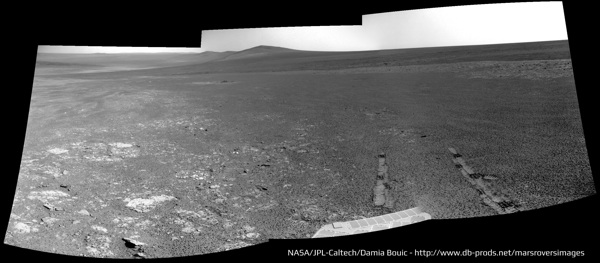
walfy
Jun 13 2013, 05:51 AM
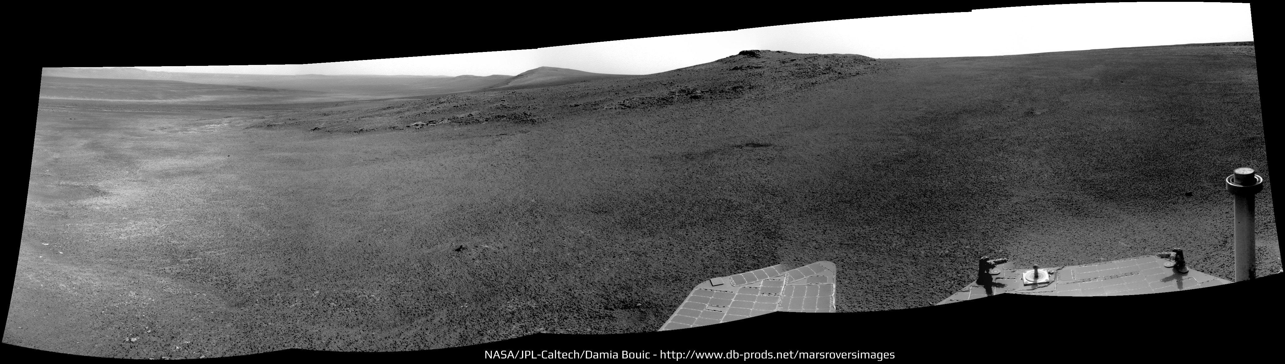
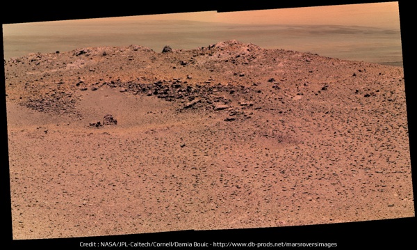
Wonderful shot of Nobby's Head on Sol 3335, with our goal in the distance:
Click to view attachment(
Hi-res copy here)
Ant103
Jun 13 2013, 10:26 AM
Yes Walfy. So much imagery this sol
A color portion of a bigger panorama, I think :
The bigger panorama, in greyscale for now :
The navcam shot, after a quick drive. Lovely ripples there
:

And the drive direction :
Tesheiner
Jun 13 2013, 11:09 AM
If I'm reading correctly, two 6x1 colour mosaics were shot on sol 3335. This is the second one, taken (almost) at the end-of-drive. The first one is still on the downlink queue and was shot before the drive, 35m to the NE.
Bill Harris
Jun 13 2013, 02:28 PM
QUOTE (Serpens)
The probable gypsum veins in this remnant of the rim are more interesting. The rim has overrun by plains material, which means that there was massive erosion of the NW edge of Endeavour prior to that event. But...
There are so many clues and questions at this line of outcrops. We got started on understanding the basics of the history of this area with the work at Cape York and we need to be following up and tying many things together as we walk this outcrop.
For example, what is the story behind the contact and outcrop at Sutherland Point?
http://www.unmannedspaceflight.com/index.p...st&p=200875 What is the lithology and nature of the several rock types seen at that site? No need to do detailed APXS or MI studies, simple Pancam Systematic Foreground or Color Clast Survey images will speak volumes. At Knobby Head, what are the similarities and differences in the (apparent) Impactite seen at CY and here? (Attached image)
Admittedly, there are time constraints in getting to Cape Trib, but it is good field practice to connect the dots was we go. On the dipping strata present here, the more deeply eroded the outcrop is and the lower in the section we can look. And this doesn't even touch on the importance of understanding the Meridiani Onlap (ie, the contact between the Endeavour strata and the post-Endeavour strata). Or the enigma of the gypsum-filled fractures that are prevalent here.
So much to do, so little time...
--Bill
Ant103
Jun 14 2013, 09:50 AM
Sol 3335, wider Navcam panorama :
ngunn
Jun 14 2013, 09:53 PM
I have a question about 'contouring'. Walking in the hills it's not uncommon to follow a contour to avoid losing height. How much does this come into play in rover operations? I note that we have gone round the top side of Nobby's Head and so kept on the level.
fredk
Jun 15 2013, 12:04 AM
The slopes are pretty subtle here and I think they could have done a direct route if they chose to. I think the approach to Nobby is mainly to do stereo imaging in case they need to use it for winter.
Also, they talked about possibly driving around and approaching from the west side of Solander, which would be easier than driving up from the east or north.
Bill Harris
Jun 15 2013, 03:45 AM
Hot off the wire... the central portion of an L257 Pancam panorama of Nobbys Head on Sol-3335:
--Bill
Phil Stooke
Jun 16 2013, 02:08 PM
Bill Harris
Jun 16 2013, 10:39 PM
This is also a good hint:
QUOTE
03339 p1205.08 2 0 0 2 0 4 front_haz_penultimate_0.5_bpp_pri17
03339 p1211.03 2 0 0 2 0 4 ultimate_front_haz_1_bpp_pri_15
03339 p1301.06 2 0 0 2 0 4 rear_haz_penultimate_1bpp_pri17
03339 p1311.07 2 0 0 2 0 4 rear_haz_ultimate_1_bpp_crit15
03339 p2388.32 10 0 0 3 2 15 pancam_drive_direction_5x1_L2R2
http://merweb.sese.asu.edu/merweb.pl--Bill
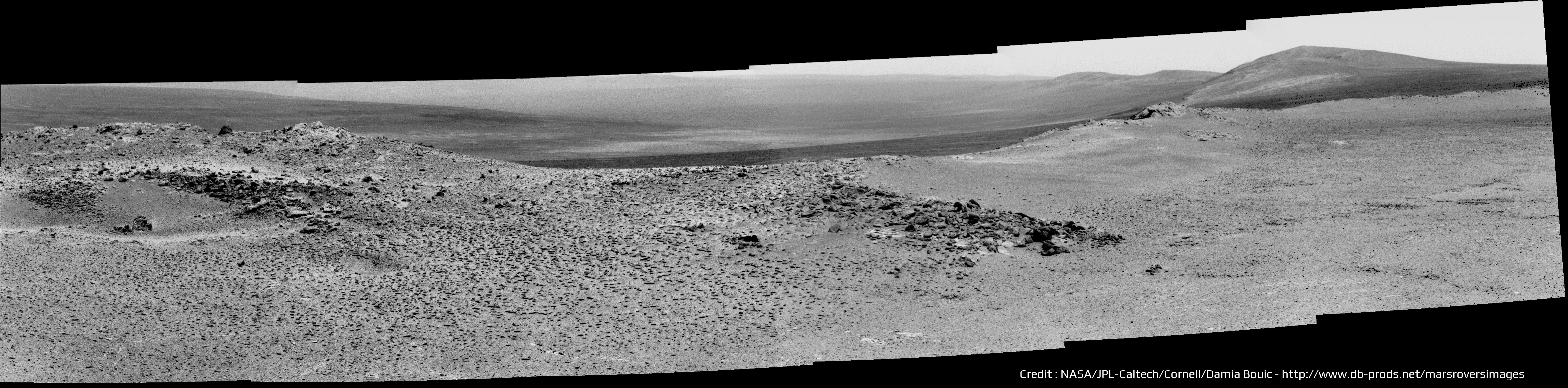
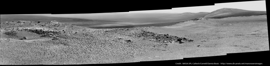
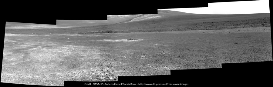
walfy
Jun 17 2013, 06:08 AM
A 3D pano from Sol 3339. Looks like we're south of Nobby's Head already, and rough plains ahead!
Solander Point is already showing a touch of parallax! Or am I imagining things.

Viewable in
this hi-res version.
Here's a smaller version:
Click to view attachment(
Full-res here)
fredk
Jun 17 2013, 02:17 PM
Thanks for the nice stereo pan, walfy. I think we'd have to be almost sitting on top of Solander before we could see parallax with pancam...
Ant103
Jun 17 2013, 07:28 PM
Navcam and Pancam for this Sol 3339 :
Nothing seems to be between us and Solander Point now
fredk
Jun 17 2013, 08:02 PM
I'm going to propose that this old degrated crater:
Click to view attachmentis visible as this wide, smooth patch:
Click to view attachmentThe direction and angular extent match well what we'd expect from the 3339 location.
Phil Stooke
Jun 17 2013, 08:49 PM
Looks like you're right. I guess we will skirt the edge of it.
Phil
walfy
Jun 18 2013, 10:11 PM
This shot renders nicely in 3D, thought I'd share it, overlooking the swale atop Nobby's Head, Sol 3339 still:
Click to view attachmentIt's always mind-blowing to look down the inner slope of this great Martian crater, especially with features in the foreground. Makes me feel like I'm there!
Tesheiner
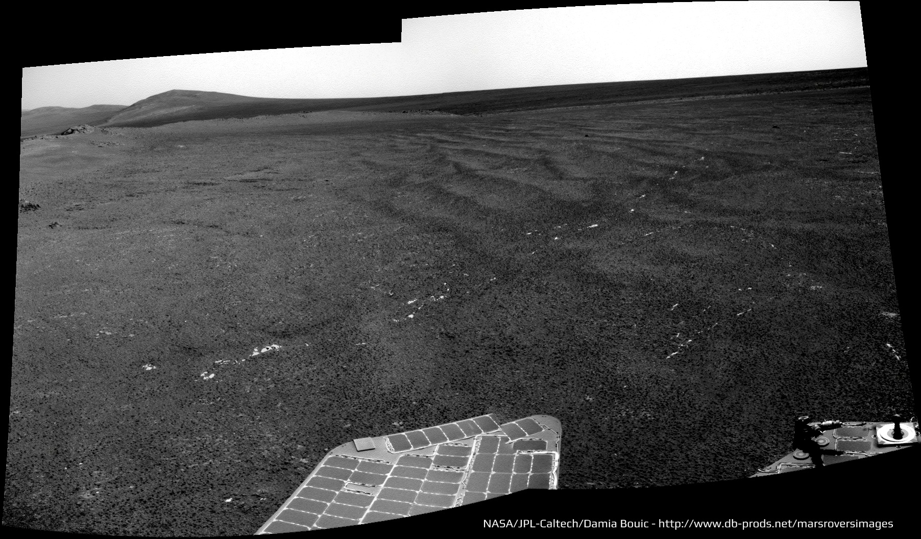
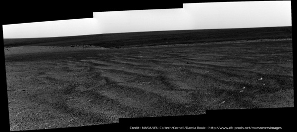
Jun 19 2013, 10:13 AM
Here's a navcam mosaic taken at the current site. It was shot during sol 3342 after driving about 54m SSE from the previous position.
Click to view attachment
MichaelT
Jun 19 2013, 03:37 PM
Nature has an interesting story on the distance travelled by Lunokhod 1 and 2 on the Moon.
The scientists from MIIGAiK in Moscow now seem to have finished their analysis using DEM data (see earlier in the thread).
Lunokhod 1: 9.93 km (instead of 10.54 as recorded in the logs)
Lonokhod 2: 42.1 to 42.2 km (instead of 37 km as recorded in the logs)
http://www.nature.com/news/space-rovers-in...rd-race-1.13229So it really seems that Oppy is still quite a long way from breaking the distance record...
Michael
Bill Harris
Jun 19 2013, 04:23 PM
Here is a parting shot of Nobby's Head by Oppy on Sol-3442. A 2x1 Navcam panorama, 3x vertical exaggeration, looking back to the North.
--Bill
Added: Here is a HiRISE image of the site, with the approximate Sol-3442 location of Oppy shown along with the sight margins of the above Navcam pano.
James Sorenson
Jun 20 2013, 02:50 AM
Just something I put together

Bill Harris
Jun 20 2013, 04:09 AM
An L257 Pancam of the site "Numbat", Sol-3342, presumably located on the Bench at Nobby's Head. Along with the corresponding R721 Pancam, there is the suggestion of a change in composition of the underlying soil unit.
--Bill
Phil Stooke
Jun 20 2013, 01:30 PM
Sol 3343 - looks like we just turned east for a short drive up to the southernmost hill of Nobby's Head.
Phil
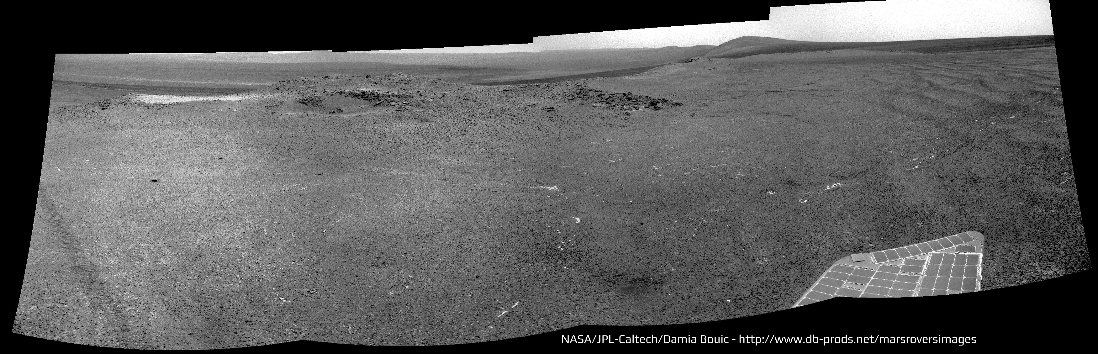
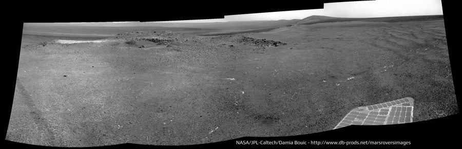
Tesheiner
Jun 20 2013, 04:16 PM
If I'm reading the data correctly, Phil, there was no drive on 3343 but there's one planned for 3344.
Phil Stooke
Jun 20 2013, 04:35 PM
Oh... OK... I was looking at this 3343 image and thinking it had to be where my lines show it here.
Phil
Click to view attachment
Bill Harris
Jun 20 2013, 05:52 PM
Tis possible-- you;re thinking that the light-toned fragments to the South (Navcam) are that low hill to the South (HiRISE)? The relief is so subdued here it's hard to tell. We have a Navcam Albedo pan on the table (with one bad frame), that would be ideal to polar project for Location. Expecting that last image just anytime...
--Bill
Tesheiner
Jun 20 2013, 05:56 PM
QUOTE (Phil Stooke @ Jun 20 2013, 06:35 PM)
Oh... OK... I was looking at this 3343 image and thinking it had to be where my lines show it here.
Perfect matching. And I think the same features are visible on the
navcam from sol 3342.
PS: Can't update the route map until the weekend. I'm travelling.
mhoward
Jun 20 2013, 07:01 PM
I think your position is correct too, Phil. The drive direction images on sol 3342 were facing east, so perhaps she's not done photographing Nobby's Head. Here's an anaglyph view.
Phil Stooke
Jun 21 2013, 12:01 AM
This is half of a circular pan from sol 3339. The low hills where we are at present (3342) are visible to the southeast of this location.
Phil
Click to view attachment
This is a "lo-fi" version of our main content. To view the full version with more information, formatting and images, please
click here.