This is Ant103's Sol 3317-3318 panorama in circular format.
Phil
Click to view attachment
Full Version: Heading south from Cape York
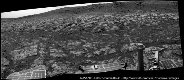
And here she is at "Sutherland Point" - or pretty close to it anyway - on sol 3324. The drive was about 79m southwest, more or less - probably more, since she didn't go in an exact straight line.
This is like ve have Mars in live from Endeavour thes days 
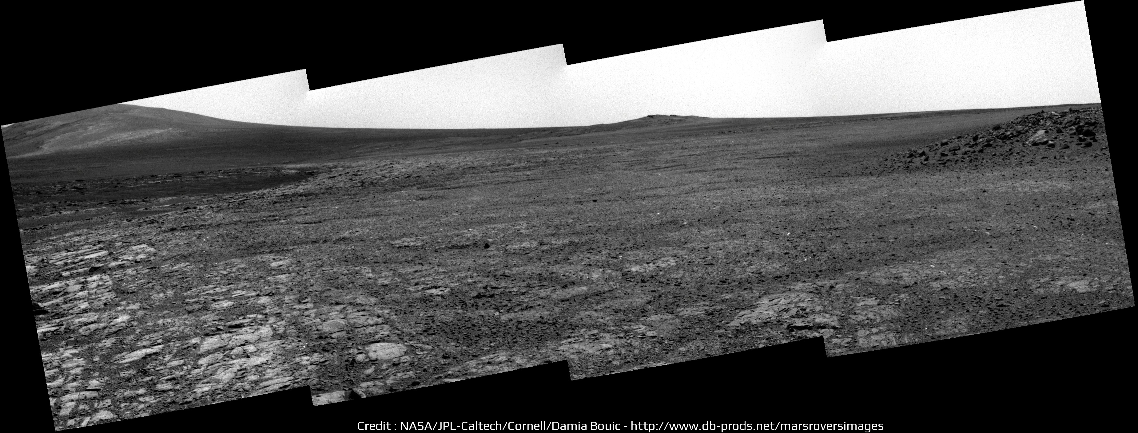
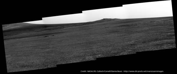
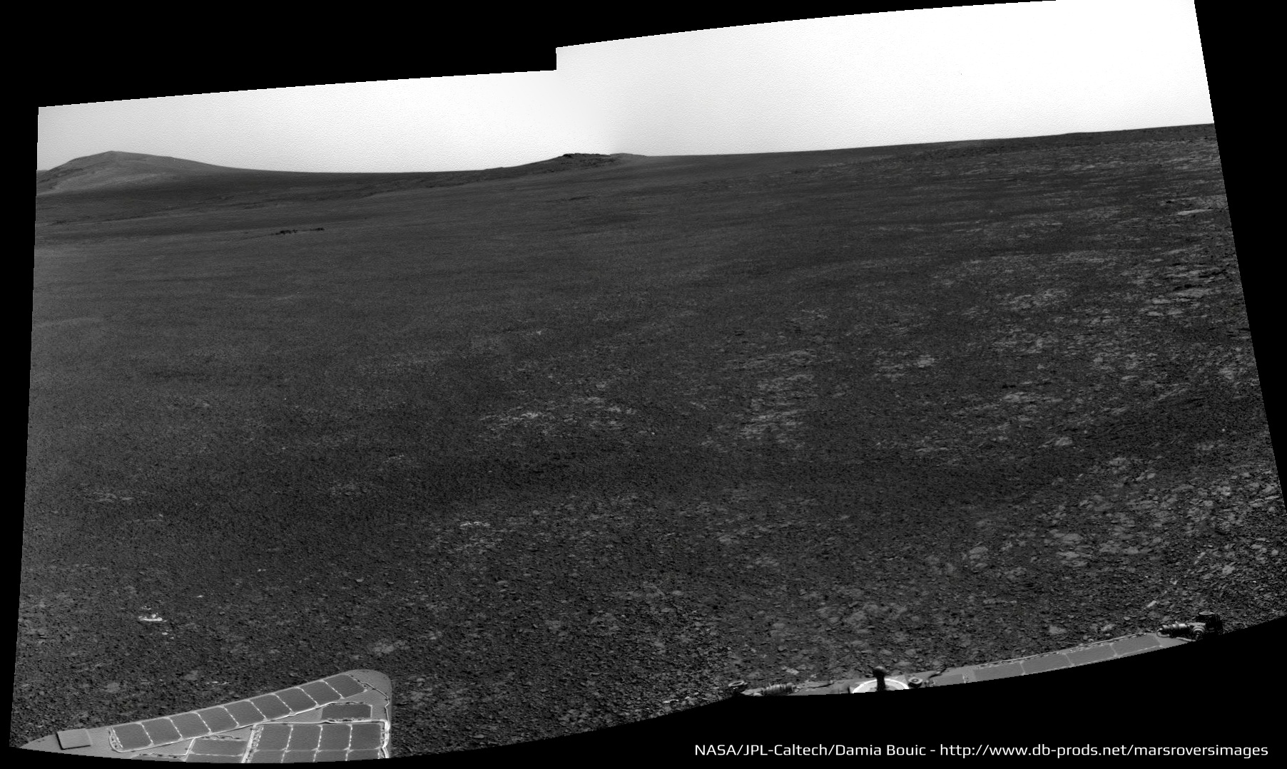
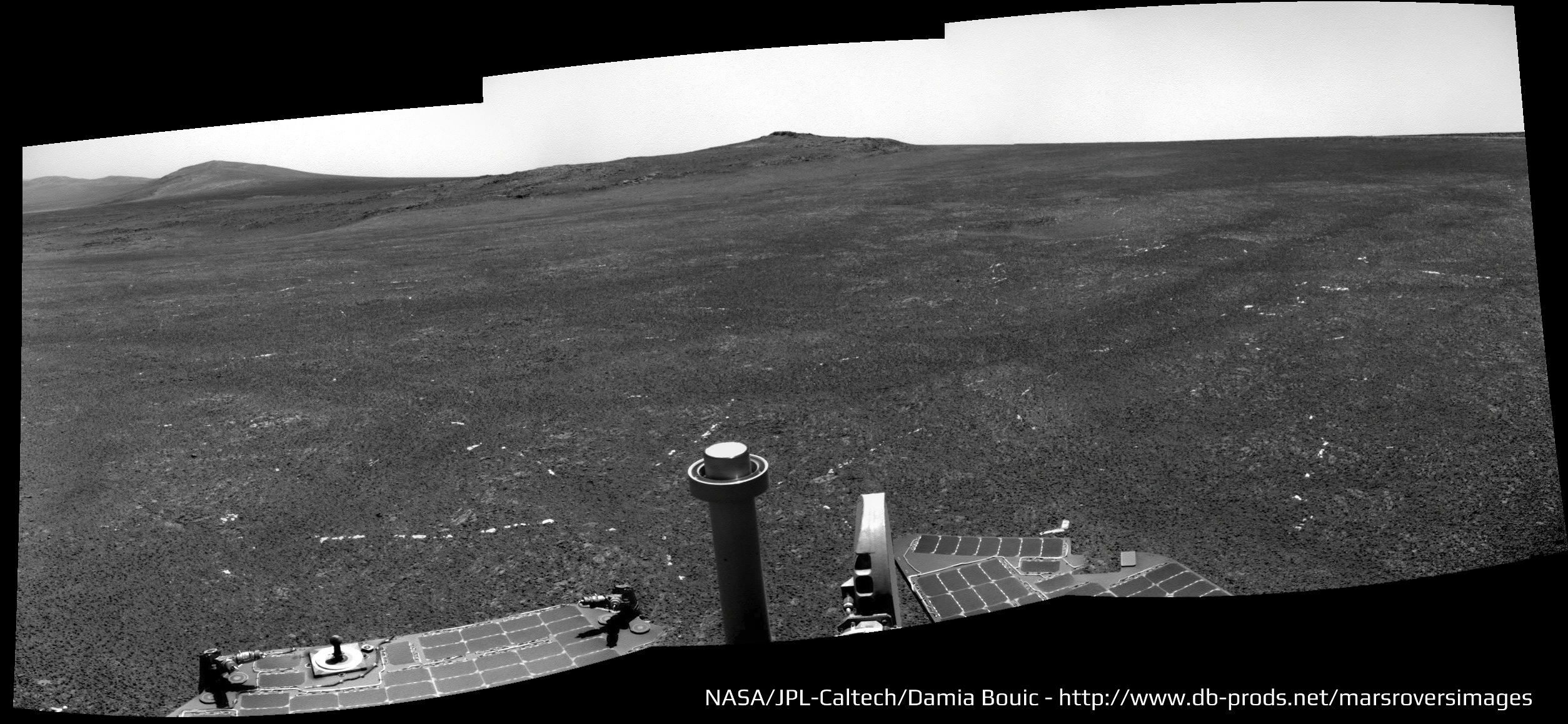
Today's pan, Sol 3324 :
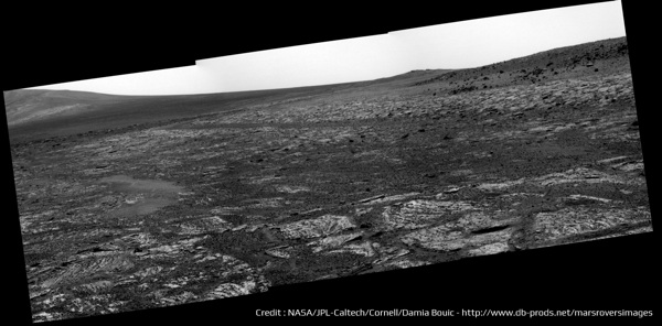
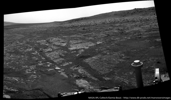
Today's pan, Sol 3324 :


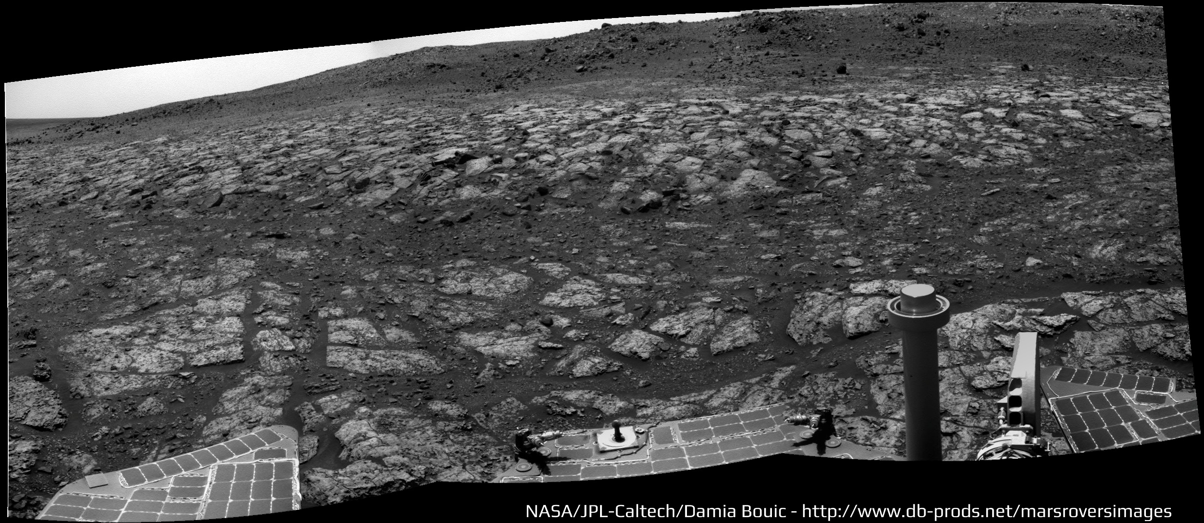
The ground at our feet is trying to tell us something. What do you suppose it is?
http://qt.exploratorium.edu/mars/opportuni...JVP2372L2M5.JPG
--Bill
http://qt.exploratorium.edu/mars/opportuni...JVP2372L2M5.JPG
--Bill
That's the ground that was at our feet, back on 3317 when we had just left CY...
QUOTE (Bill Harris @ May 31 2013, 01:36 PM) 
The ground at our feet is trying to tell us something....
It's saying 'welcome back to the layered sulphate sandstone and blueberry lag of the Meridiani plain.' 
Not quite. Botany Bay sulphates are supposed to be well hydrated in comparison to the plain. Perhaps it is just my ageing eyes but despite the lag of big juicy berries, embedded berries seem extremely sparse. - almost as though the lag originated external to the crater.
QUOTE (serpens @ May 31 2013, 08:12 PM)
...despite the lag of big juicy berries, embedded berries seem extremely sparse....
Looks like that to me too. I also thought the image linked by Bill Harris (on right) resembled a spot on the rim of Erebus crater (on left) seen on sol 634. (Images not to same scale(?))Click to view attachment
As seen in this Opportunity route map,
Click to view attachment
the left (sol 634) image is from the area labeled Olympia Outcrop here:
Click to view attachment
http://www.gps.caltech.edu/~grotz/Publicat...Metz_Erebus.pdf
(Edited to add route map and add "?" to scale comment.)
QUOTE (Bill Harris @ May 31 2013, 10:36 AM)
The ground at our feet is trying to tell us something. What do you suppose it is?
That we should all get rid of our trendy travertine tile kitchen flooring and go with the more pleasing sinuous appearance of a nice polished and sealed layered sandstone?
Looks like we have now hopped up onto the bench surrounding Sutherland Point. More to follow.
Phil
Phil
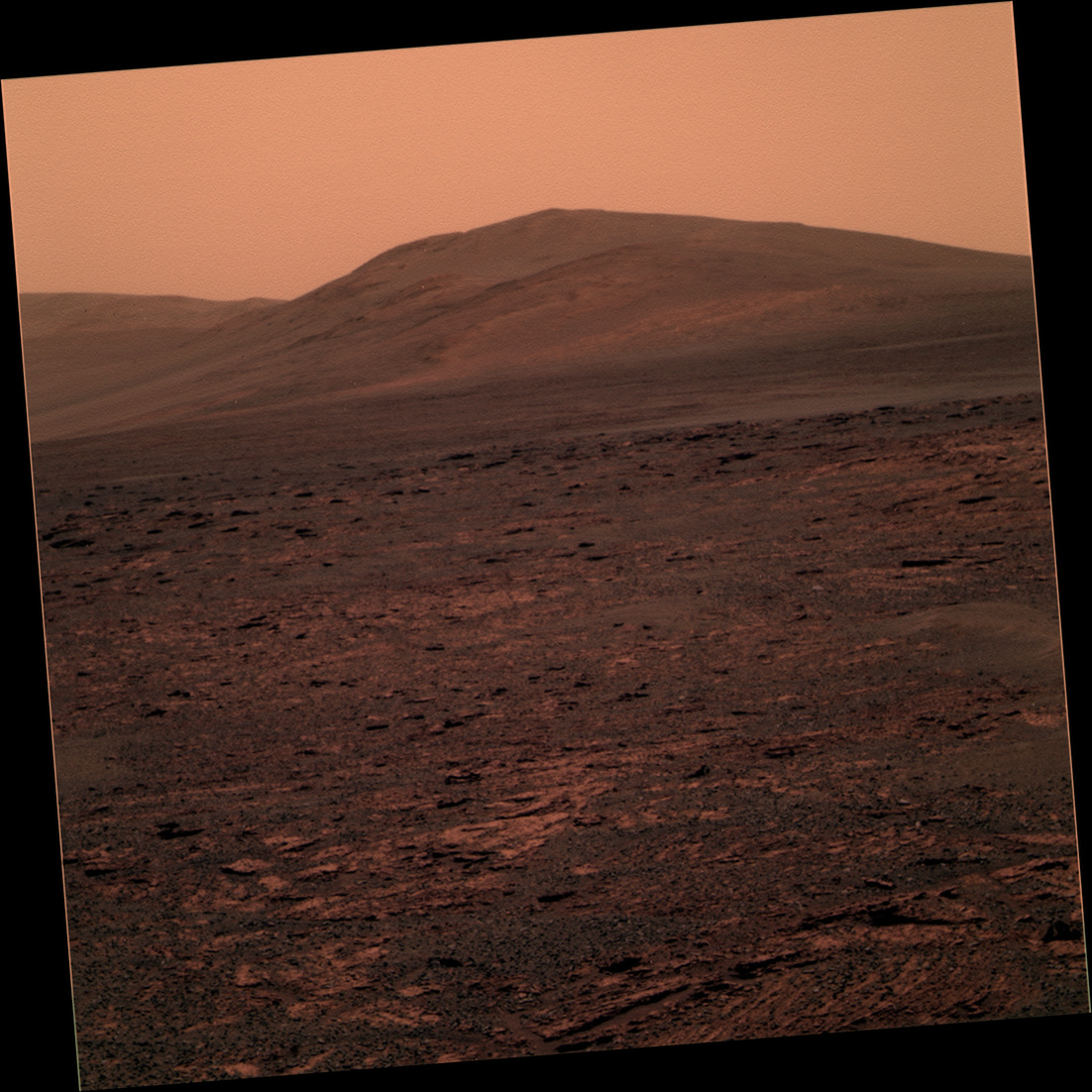
A nice view of Solander Point & Cape Tribulation down thissol. Details becoming clearer.
http://qt.exploratorium.edu/mars/opportuni...GHP2585L5M1.JPG
http://qt.exploratorium.edu/mars/opportuni...GHP2585L5M1.JPG
http://www.midnightplanets.com/web/MERB/im...SP2378R2M1.html
Any relation to MMB?
>Gypsum veins
May be, but it's a stretch with this/these views-- I see a few light-toned flakes which may be arranged linearly.
Given the genesis of these filled fractures, it's not surprising.
--Bill
Any relation to MMB?
>Gypsum veins
May be, but it's a stretch with this/these views-- I see a few light-toned flakes which may be arranged linearly.
Given the genesis of these filled fractures, it's not surprising.
--Bill
QUOTE (Bill Harris @ Jun 2 2013, 04:51 PM)
Any relation to MMB?
Yes: successor!
"it's a stretch "
Yes, it is. But I think that's what they are. We'll see, as we get further on. This is quite a cute little mini-Cape York.
Phil
Yes, it is. But I think that's what they are. We'll see, as we get further on. This is quite a cute little mini-Cape York.
Phil
I'm on the hopeful lookout more examples of the "gypsum veins". They are the remnant of some wonderful geochemistry. Clays are weathering byproducts but fracture fills are (or can be) the fingerprints of the weathering processes.
> Yes: successor!
And wonderful, too !! I spent the last couple of hours twiddling with it. I'm a traditionalist, and like to go into Exploratorium and "shop", but when the relay comms get a bit spotty and we don't get all the images in neat packages the manual browse can be tedious. I just got caught up on my missing L 2, 5, and/or 7 post-conjunction images.
Kudos.
--Bill
I attempted an 'ad hoc' long-baseline stereo pair 'a la fredk'. It's composed of two views toward Solander Point taken on Sol 3325, before and after drive. Since the drive wasn't really lined up to produce stereo, view this image at your own risk - it may induce nausea.
It actually came out a lot better than I was expecting. Once again, I find I was misinterpreting the monoscopic views, and now I can see where Solander Point actually is - which is not exactly where I thought it was! For those without red-cyan glasses, I'm including a 'freeviewing' version, plus separate left and right frames if you'd like to do a blink comparison.
Also: quick flicker gif a la Gerald.
Many images on this Sol 3325
Begin with the drive "pancam" direction :

The color view of Cape Tribulation & Solander Point :

Two Navcam panoramics. One before moving, and one after :
Begin with the drive "pancam" direction :
The color view of Cape Tribulation & Solander Point :
Two Navcam panoramics. One before moving, and one after :
Cape Tribulation from Sutherland Point, Sol-3325:
--Bill
--Bill
http://qt.exploratorium.edu/mars/opportuni...1NP1211L0M1.JPG
Looking back, with Sutherland Point at the left, quite far behind already. Just had a good drive!
Phil
Looking back, with Sutherland Point at the left, quite far behind already. Just had a good drive!
Phil
About 100m S-SW according to the metadata.
http://qt.exploratorium.edu/mars/opportuni...1NP1952R0M1.JPG
Those white lines have just got to be gypsum veins again! It would be nice if a really good wide example was waiting for us on Solander Point, because a vein wide enough to brush and analyze properly was never found at Cape York. Homestake and Monte Cristo were too small, if I'm remembering correctly - sure we got some data from them, but not enough. But they only seem to show up on the outer apron, not up on top of Cape York so probably not up too high on Solander either. Oh well, keep looking...
Phil
My thoughts exactly. These look more probable.
Here is an X-eyed Stereo view looking due East from Sutherland Point over the Overlap/Bench area on Sol-3329. Note the probable light-toned veins in the foreground and the wonderful stratigraphy in the midground. The interior dunes and central mound of Endeavour Crater are on the horizon.
--Bill
Here is an X-eyed Stereo view looking due East from Sutherland Point over the Overlap/Bench area on Sol-3329. Note the probable light-toned veins in the foreground and the wonderful stratigraphy in the midground. The interior dunes and central mound of Endeavour Crater are on the horizon.
--Bill
Heading Nobbys Head, at Sol 3328 :

And a closer look with Pancam :
And a closer look with Pancam :

An Opportunity telecon is coming up on Friday
http://www.jpl.nasa.gov/news/news.php?release=2013-192
It would be nice to get an update on findings... but maybe there will also be some news about distance records. There is some news but let's see if it gets mentioned tomorrow.
Phil
http://www.jpl.nasa.gov/news/news.php?release=2013-192
It would be nice to get an update on findings... but maybe there will also be some news about distance records. There is some news but let's see if it gets mentioned tomorrow.
Phil
Now that I'm getting caught up with the recent imagery, I'd like to share an image of part of the Ringtail outcrop in the Meridiani Onlap/Cape York, an L257 taken on Sol-3317. Nice colors, nice sedimentary structure-- our old friends, the Fine Laminations and Burple Strata.
--Bill
--Bill
OK.. last question touched on Lunokhod 2. Steve was non-committal in his answer. Let me point interested parties to this Russian presentation from last year:
http://meetingorganizer.copernicus.org/EPS...PSC2012-464.pdf
In it you may find a surprise. A much longer distance, 42 km. And I can say that the more refined answer now is thought to be 42.1 km.
Why is this? The old value was based purely on engineering data, wheel turns and drive times etc. There was no chance to compare locations after each drive as we do now for Opportunity and Curiosity, because the available orbital imagery was inadequate. The engineering data are good for short drives but drift away from the correct value quite rapidly because of wheel slip and maybe sensor errors. Now we can check the actual distance using LRO images of tracks, and that's what the people at the mapping lab at MIIGAiK in Moscow are doing. They are not quite finished because they don't yet have high resolution DEMs for the whole traverse.
The old value was quite short, 5 km shorter than the new value. I think it is because they assumed a lot more slip than actually experienced, but it might also be a sensor problem. For Lunokhod 1 the new drive distance from LRO track mapping is 9.5 km, shorter than the old estimate - so you can see it's not very straightforward.
This is not really unique to Lunokhod 2. See this paper:
http://www-robotics.jpl.nasa.gov/publicati.../05pers_mer.pdf
or this one:
http://www.lsgi.polyu.edu.hk/staff/Bo.Wu/p...se_slippage.pdf
MER also has its issues with this, but we can fix the problem with the method called Bundle Adjustment in that paper. The Lunokhod team could not. Final result of all this - we have quite a way to go before we can be confident of beating that old record.
Phil
And then the actual ground distance traveled may be greater than the simple map distance due to the effect of rolling over the topography. Complex situation.
--Bill
--Bill
Complex and interesting since, just for the record, a Marathon is 42195m. Don't tell me that Lunokhod 2 stopped 95m short to complete the task! Serriously, you're right, we have to wait to exceed and be sure.
Going through archives and looking at images of the Meridiani Onlap during the approach of Cape York around Sols-2676-2681 I came across this: a Navcam pano with 3x vertical exaggeration taken from the Meridiani Onlap on Sol-2679 showing Cape York on the left, Odyssey Crater in the center with Cape Tribulation above center on the right and Sutherland Point/Knobby's Head in the area just below right center.
It's deja'vu all over again...
--Bill
Note-- updated the attached image to a "slightly improved", wider version.
It's deja'vu all over again...
--Bill
Note-- updated the attached image to a "slightly improved", wider version.
That is such a killer image on so many levels.
It even makes me feel seasick!
Phil
Phil
Takes me back to the old Spirit route map days, with the valley between Husband and McCool hills, and Home Plate....
It gives me a touch of vertigo seeing and thinking about the Central Mound and the Eastern Rim of Endeavour off in the distance behind Cape York... 
Ideally, it would be nice to have a similar treatment of a similar Pancam panorama, but in reality Oppy was zipping along on the fast-track to get to Cape York ASAP, so I'm thinking that this Navcam sequence will be all we've got.
Aye, It reminds me of the heady days of Sputnik and Gagarin when the world trembled at the sound of our (rovers)...
--Bill
Note-- updated the attached image in Post#131 to a "slightly improved", wider version.
In case anyone's confused by the recent press image that shows the sol 3325 view towards Solander and Tribulation, they've mislabelled those two features. Solander and Tribulation (and Byron behind it) are very closely aligned now, as you can see from this orbital view:
Click to view attachment
The area labelled "multiple rock strata" and "bench" in the press image is Solander, and the area labelled "Solander" is actually Tribulation. The area labelled "Tribulation" is actually Cape Dromedary, much farther away.
Click to view attachment
The area labelled "multiple rock strata" and "bench" in the press image is Solander, and the area labelled "Solander" is actually Tribulation. The area labelled "Tribulation" is actually Cape Dromedary, much farther away.
Interesting. That did puzzle me, but I think you're right.
Adding: Earlier I did this ID of Solander Point, which I think matches up with what you've labelled. (When they posted that slide, I figured I'd got it wrong again.)

MERSol3324LabelledView on Flickr
Adding: Earlier I did this ID of Solander Point, which I think matches up with what you've labelled. (When they posted that slide, I figured I'd got it wrong again.)
MERSol3324LabelledView on Flickr
Yes indeed, Fredk is right.
Phil
Phil
I don't think it was an error as much as it was sloppy graphics-- the annotations were in their correct locations, they just needed arrows drawn down to the hills.
I've always looked at Tribulation as "that big hill over thar" and Solander as "them foothills"...
--Bill
I've always looked at Tribulation as "that big hill over thar" and Solander as "them foothills"...
--Bill
But the caption says
Mistakes happen - no big deal.
QUOTE
The southward-looking scene... shows Solander Point on the center horizon... and "Cape Tribulation" in the far background at left.
Mistakes happen - no big deal.
Well, I guess the caption does shred their cred...
--Bill
--Bill
I just noticed all the frames of "Esperance" post-RAT on Opportunity sol 3308 are down. Here's the stretched L456. Beautiful.
That is beautiful. What a gallery of rocks we could put together now!
Phil
Phil
QUOTE (Bill Harris @ Jun 7 2013, 09:35 AM)
... I'd like to share an image of part of the Ringtail outcrop in the Meridiani Onlap/Cape York, an L257 taken on Sol-3317. Nice colors, nice sedimentary structure-- our old friends, the Fine Laminations and Burple Strata. ...
I haven't seen as much of the purple-hued sediment as I thought we would around the Capes. When we first saw the stuff I thought it had to be some form of mineralization or diagenesis. Eventually I came across a paper that suggested a correlation between the purple hue and hydrated sulfates. I think that conclusion was based on a "hydration index" calculated with the pancam near infrared filters. If anyone recalls which paper that was I'd appreciate a reminder, as I can't seem to find it in my collection of pdfs.
By the way, where did we first see the purple hues in the Burns formation? I was thinking it was somewhere around Erebus Crater.
I'm think of the "Burple Rocks" being associated with Santa Maria Crater (Sol 2450-2546) and consequently the lower units of the Burns Fm, as was that Brown-Toned rock type, and others. I think of Erebus as being more about the Festooned Beds and the Weathering Rinds on rock surfaces. Or so my creaky memory sez.
I've been going through and organizing the images better and categorize everything in a searchable relational database. Been putting this Herculean task off for years, though I do have the work on some some sites started. But now that I've "discovered" Midnight Planets ( http://www.midnightplanets.com/index.html ), it will make this organizationizing (is that a word??) much easier. Thanks, Mike Howard!!!!
Currently, I'm focused on the "Meridiani Onlap", that critical contact between the Meridiani Burns Formation and the earlier weathered Endeavour ejecta apron. We have many images of that zone from the Cape York approach and many from the Cape York exit.
So much to do, so little time.
Thanks for the Espernace RAT images, Mike. I've been waiting on images to come dribbling in on that area (the usual post-conjunction logjam). Time to move _that_ off'n the back burner, too...
BTW, in the data pipeline today (?) we have a series of MIs of the soil at Knobby's Head and Pancams of a new site named "Gnarlaroo". On my Wish List at this site? Those dunes on the eastern side of the Knobby Bench... an opportunity to sample wind-transported material from inside Endeavour Crater. Both the light-toned longitudinal dunes and the dark-toned pre-barchans.
Stay tuned...
--Bill
On the road North to Nobbys Head (Sol 3330)


(Tosol we are Sol 3333, all the same numbers)

(Tosol we are Sol 3333, all the same numbers
)
QUOTE (Bill Harris @ Jun 9 2013, 04:08 AM)
Thanks, Mike Howard!
Don't tell anyone (just kidding), but in a few weeks I should have processed calibrated images from the PDS, plus MER-A. I still have to reduce the images to 8-bit JPGs for my purposes, so they won't be suitable for science, but it makes for much better browsing. Slow progress.
This is what our Intrepid Explorer is up to:
First is a crop of the HiRISE image ESP_018701_1775_RED.JP2 showing the northern part of Knobby's Head. It is inverted so that South is up so that it can be viewed in context with the next Pancam pan. The "*" shows the guesstimated location of Oppy on Sol-3330 and the arrow shows the approximate look direction. Those tasty dunes I mentioned earlier are in the upper left of this image, but I'll s'pose that the drive direction will be towards upper right.
And next is a panorama of the leftmost two images of the Pancam "next-drive" image set, cropped and exaggerated 3x. View is to the Southwest.
And so it goes...
--Bill
Back a few sols, on Sol 3308, Oppy has imaged her tracks in color :


QUOTE
in the data pipeline today we have a series of MIs of the soil at Knobby's Head...
Initial impression: angular fragments, composed of angular clasts, in a (basaltic) sandy soil.
http://www.midnightplanets.com/web/MERB/im...3P2935M2M1.html(Sol-3332)
At this site: http://www.midnightplanets.com/web/MERB/im...3P1214L0M1.html (Sol-3330 FHazCam, pre-IDD deployment) and http://www.midnightplanets.com/web/MERB/im...3P1291L0M1.html (Sol-3330 FHazCam, post-IDD deployment).
--Bill
This is a "lo-fi" version of our main content. To view the full version with more information, formatting and images, please click here.