Be sure to check out the "Merged RGB: map-projected" JP2 product, under "JP2 Extras", if you can. Everything from Cape York down to Solander Point and beyond, in glorious false color. Absolutely amazing.
Or, just check out Emily's blog post.
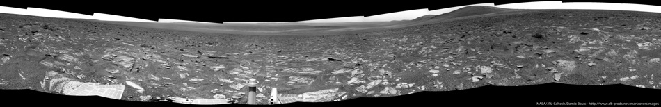
Full Version: Heading south from Cape York
No tracks in Botany Bay, for sure, but quite a few on Cape York itself, at least on Matijevic Hill and south of it.
Phil
Phil
Gee -- almost everywhere else Oppy has been at Meridiani has had enough soil (or regolith, take your pick) to leave good, recognizable tracks, even in the absence of ripples/drifts. I wonder what processes are at work here in the Bay to strip a majority of the fines that you'd otherwise expect?
-the other Doug
-the other Doug
Mosaic of the rocky floor toward the crater (Sol 3369) :


Here's a first attempt at an anaglyph for the sol 3366 long baseline stereo Pancam mosaic. Not quite all of the images are down yet.
About 60.5m on Sol 3371. Here's where I think she is... I wanted to see how this worked on the color map. I like the color, but I think it's easier to do the actual mapping on the slightly higher resolution grayscale image.
Did you try the color image I posted in my blog? I draped the color over the higher-res red image.
I hadn't noticed that you'd done it that way; that's actually quite nice. Here are the positions redone on your background.
I think using grayscale ESP_018701_1775_RED.JP2 is still somehow easier, though.
I'm not at all confident of the sol 3371 position; once again, few images and very subtle landmarks. But it should be in the ballpark. Probably.
I think using grayscale ESP_018701_1775_RED.JP2 is still somehow easier, though.
I'm not at all confident of the sol 3371 position; once again, few images and very subtle landmarks. But it should be in the ballpark. Probably.
Very tricky! I don't have a location to suggest but I can offer this reprojection of the two navcams we have so far.
Phil
Click to view attachment
Phil
Click to view attachment
A bit more info about the recent downward drives in the latest update:
QUOTE
they decided to use a few of the margin sols accumulated to investigate an area of interesting terrain and gypsum signatures.
That small crater we were talking about to the east on sol 3369? That's crater "Charlie Brown" apparently. They did a drive-by of it on sol 3371.
Sol 3374 complete panoramic :
We can see a lot of features like Cape York, far away, to the left, Cape Tribulation which became visible due to the drive estward, and of course Solander Point.

We can see a lot of features like Cape York, far away, to the left, Cape Tribulation which became visible due to the drive estward, and of course Solander Point.
Nice! FWIW, this drive was about 50m SSE.
Map update soon...
Edit: Even with this 360º mosaic I'm finding really difficult to correlate it with the HiRISE background. No clue.
Map update soon...
Edit: Even with this 360º mosaic I'm finding really difficult to correlate it with the HiRISE background. No clue.
Right - we've never had such a difficult place to work with.
Phil
Phil
True. I still remember how easy it was while travelling by the dune seas.
Yes, see what you've been missing on vacation? That is, mostly eyestrain.
Here's my guess on the color map.It's a little NW of yours, I think. Edit: adjusted to match Phil's position, so pretty much in the same place now, probably.
That is, mostly eyestrain.Here's my guess on the color map.
Yeah, this may be the toughest site to localize yet.
In extreme situations like this, I wonder how hard it would be to turn the 360 navcam mosaic into some kind of equal-area-ish projection to be able to compare more directly with the hirise view. Of course it would only be approximate, due to the surface being not exactly flat. Also, you'd have to estimate the scale based on the height of navcam and angle of view below horizon.
Even with the inevitable distortions, shadowing effects, and scale error, it might still allow you to pinpoint the location by blinking between the navcam and orbital views and shifting one until you find good agreement. The distortions would be worse farther away, but maybe you'd only need to go out 30 metres or so to get a good match.
That is what the professionals do. Best results, of course, if the reprojection is controlled by a stereo model from the Navcam stereo pan.
Phil
Phil
Ah, yes, that's much more convincing. I've updated my position to match Phil's.
Yes, I think that's it. And in this case this position fits quite well with the one calculated by the rover itself.
QUOTE (Ant103 @ Jul 22 2013, 01:19 PM) 
Sol 3374 complete panoramic :
Damia, c'est vraiment SUPERBE !!! Un grand merci !

Merci beaucoup Olivier
http://www.midnightplanets.com/web/MERB/im...EP2412L7M1.html
The rocks are layered like so many we've seen before, but they look like very coarse-grained, gritty layers here.
Phil
The rocks are layered like so many we've seen before, but they look like very coarse-grained, gritty layers here.
Phil
Your right Phil. Unfortunately I guess that the limited time before the rover has to get to a slope along with observation priorities precluded more than a drive-by snapshot. The erosion pattern would seem to indicate a coarse to fine deposition cycle indicating energy variation. Wonder if these are similar to Cortez on the edge of CY which had what appeared to be a cyclical and sinusoidal deposition pattern of thin bundled laminations interspaced with thick deposition from high energy events. On Earth that is evident in tidal bundles but on Mars?
Another move on 3376, but this one's easy to locate since it looks like a very short drive, maybe to take a quick peek at a rock?
http://qt.exploratorium.edu/mars/opportuni...0M1.JPG?sol3376
http://qt.exploratorium.edu/mars/opportuni...0M1.JPG?sol3376
We've definitely been observing some changes in the layering characteristics of some rocks in the Burns formation. I really hope they find time to do some investigation of a few rocks down here on the plains. I think I am still seeing a lot of aeolian forms since Cape York, but there seem to be small areas where the rocks appear differently.
QUOTE (fredk @ Jul 24 2013, 06:15 AM)
Another move on 3376, but this one's easy to locate since it looks like a very short drive, maybe to take a quick peek at a rock?
http://qt.exploratorium.edu/mars/opportuni...0M1.JPG?sol3376
http://qt.exploratorium.edu/mars/opportuni...0M1.JPG?sol3376
Yep. Here's the rock as seen on a FHAZ taken from the previous site.
Click to view attachment
Deimos in transit:
http://qt.exploratorium.edu/mars/opportuni...8M1.JPG?sol3376
Edit:
Animation sped up 100x:
Click to view attachment
And in realtime, 1 frame per 10 seconds:
Click to view attachment
http://qt.exploratorium.edu/mars/opportuni...8M1.JPG?sol3376
Edit:
Animation sped up 100x:
Click to view attachment
And in realtime, 1 frame per 10 seconds:
Click to view attachment
Some good details in Crumpler's latest blog post
More details about what interested them in the current location, and plans for the approach to Solander:
More details about what interested them in the current location, and plans for the approach to Solander:
QUOTE
on Friday, July 26 we will probably be on our way to the northeast edge of Solander point. There... we will sidle up to the contact between the mountain and the plains on the east side and move northwest to the very northern tip of Solander Point. There we will climb up onto the bench that characteristically outlines the base of the mountain. All sorts of geologically strange things appear to be converging there, so we will hopefully have time to hammer out the geology before beginning the Long Climb.
I wasn't aware of that blog! Bookmarked.
When he speaks about Friday's (i.e. today's) plans I presume he's actually talking about sequences planning. I would expect the drive itself to be executed on saturday or sunday with images available sunday / monday. Let's wait and see.
BTW, we might be reaching the 38km mark on the next move.
When he speaks about Friday's (i.e. today's) plans I presume he's actually talking about sequences planning. I would expect the drive itself to be executed on saturday or sunday with images available sunday / monday. Let's wait and see.
BTW, we might be reaching the 38km mark on the next move.
Click to view attachmentWell that looks like isopachous cement? First real sign of plentiful water in the crater itself.
Edit: That is "Black Shoulder". Looks like the naming is continuing the Australian theme.
Edit: That is "Black Shoulder". Looks like the naming is continuing the Australian theme.
Quick L257 of "Tawny" on Sol 3353.
Click to view attachment
Click to view attachment
That's pretty ugly.
Yeah, I think he was in The Hobbit. Not as a hobbit.
Phil
Phil
I see a troll myself. Rather appropriate, given that its in sunlight and made of rock....

My first attempt at an MI mosaic, using 4 images of the RAT area from Sol 3382. Not perfect, but neither was the original lighting.
Click to view attachment
Click to view attachment
Nice mosaic!
We had a good drive on 3385, and we are approximately here now:
Click to view attachment
Click to view attachment
Phil
We had a good drive on 3385, and we are approximately here now:
Click to view attachment
Click to view attachment
Phil
About 115m SW (from the metadata). And the 38km mark already is waaay behind us.
Just showing Curiosity she's still got it!
Phil
Phil
Hehehe. 
I checked the new position calculated using the metadata and later on adjusted it with my own version of polar mosaic (normal business) and they offset by almost 20m! Quite big, even considering such a long drive.
I'm pretty convinced of the registering I did; actually, if fits with yours almost exactly. Dunno exactly the reason for such difference; my guesses are that it might be due to distortions on the basemap I'm using (PSP_10341), inaccuracy of the previous position (sol 3384), drifting of the rover's autonomous attitude calculation (source of the metadata), a combination of all these factors, ... dunno.
http://qt.exploratorium.edu/mars/opportuni...E2P2415L7M1.JPG
Woah! That's a dramatic and enticing looking hillside. Who back in 2004 would have imagined Opportunity being somewhere like this?
Woah! That's a dramatic and enticing looking hillside. Who back in 2004 would have imagined Opportunity being somewhere like this?
New update from Larry Crumpler
http://www.nmnaturalhistory.org/rover-fiel...-from-mars.html
...and it looks like 3387 will be the arrival sol!
http://www.nmnaturalhistory.org/rover-fiel...-from-mars.html
QUOTE
It packed up and started driving towards the base of the mountain and will be at the foot of the next mountain after the drive this weekend.
...and it looks like 3387 will be the arrival sol!
QUOTE
03387 p0025.01 0 0 0 0 0 0 mer_b_sunfind_parms_left_eye_525_exp
03387 p0733.03 0 0 0 0 0 0 navcam_3x1_az_234_3_bpp
03387 p1205.08 0 0 0 0 0 0 front_haz_penultimate_0.5_bpp_pri17
03387 p1211.03 0 0 0 0 0 0 ultimate_front_haz_1_bpp_pri_15
03387 p1234.06 0 0 0 0 0 0 front_haz_fault_half_pri15_4bpp
03387 p1254.02 0 0 0 0 0 0 front_haz_fault_pri15_4bpp
03387 p1301.06 0 0 0 0 0 0 rear_haz_penultimate_1bpp_pri17
03387 p1311.07 0 0 0 0 0 0 rear_haz_ultimate_1_bpp_crit15
03387 p1334.00 0 0 0 0 0 0 rear_haz_fault_half_pri15_4bpp
03387 p1354.01 0 0 0 0 0 0 rear_haz_fault_pri15_4bpp
03387 p2111.06 0 0 0 0 0 0 pancam_cal_targ_L234567Rall
03387 p2418.32 0 0 0 0 0 0 pancam_drive_direction_4x1_L2R2
03387 p2546.32 0 0 0 0 0 0 pancam_Crystal_Creek_half_L234567Rall
03387 p2601.05 0 0 0 0 0 0 pancam_tau_L78R48
It looks like we're just offshore from Solander now:
http://qt.exploratorium.edu/mars/opportuni...0M1.JPG?sol3387
Perhaps time to start a new thread...
http://qt.exploratorium.edu/mars/opportuni...0M1.JPG?sol3387
Perhaps time to start a new thread...
QUOTE (fredk @ Aug 4 2013, 03:18 PM)
Perhaps time to start a new thread...
Opportunity is still "heading south from Cape York" as it climbs Solander Point. So, there will never be a valid reason to end this thread.
QUOTE (SFJCody @ Aug 3 2013, 04:13 PM)
Woah! That's a dramatic and enticing looking hillside. Who back in 2004 would have imagined Opportunity being somewhere like this?
After 10 years sailing over Meridiani Planum and diving into every crater along the way, Opportunity now have the chance to climb a montain. Still beyond all expectations.
What else after that? Flying ...
QUOTE (fredk @ Aug 4 2013, 07:18 AM)
Perhaps time to start a new thread...
Yes, I think so. Not much to go in the new thread yet, but there probably will be soon; so let's go.
As usual, discussion and images pertaining to earlier sols go in the appropriate threads; check the sol ranges in the topic subtitle.
Some drilling action from sols 3380-3384.
Click to view attachment
Click to view attachment
This is a "lo-fi" version of our main content. To view the full version with more information, formatting and images, please click here.