Full Version: Heading south from Cape York
We had one long-running poll here years back and the back-and-forth arguing both during the drive and after the goal was reached became so annoyingly dull that polls have been banned here ever since.
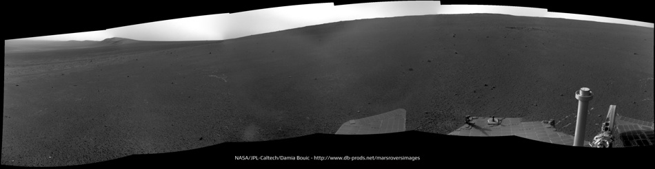
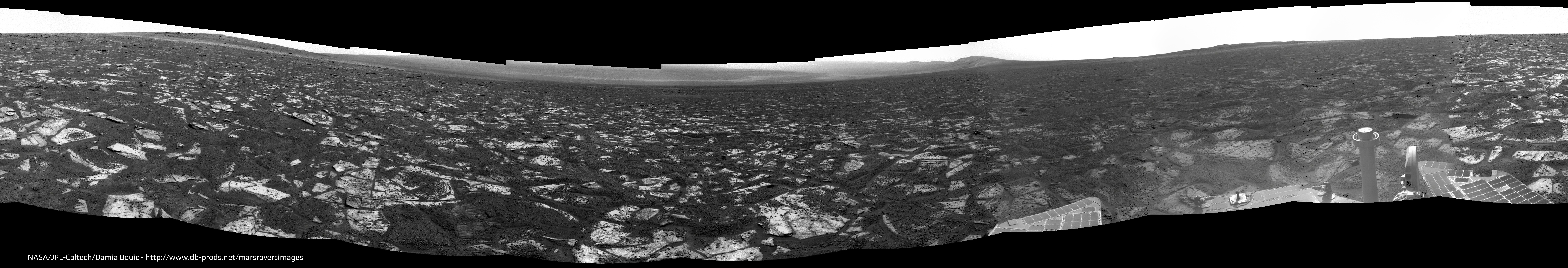
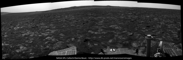
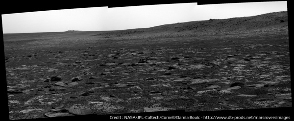
Sol 3312 panoramas :
Navcam
Pancam, drive "yes it's good to read drive " direction :
Navcam
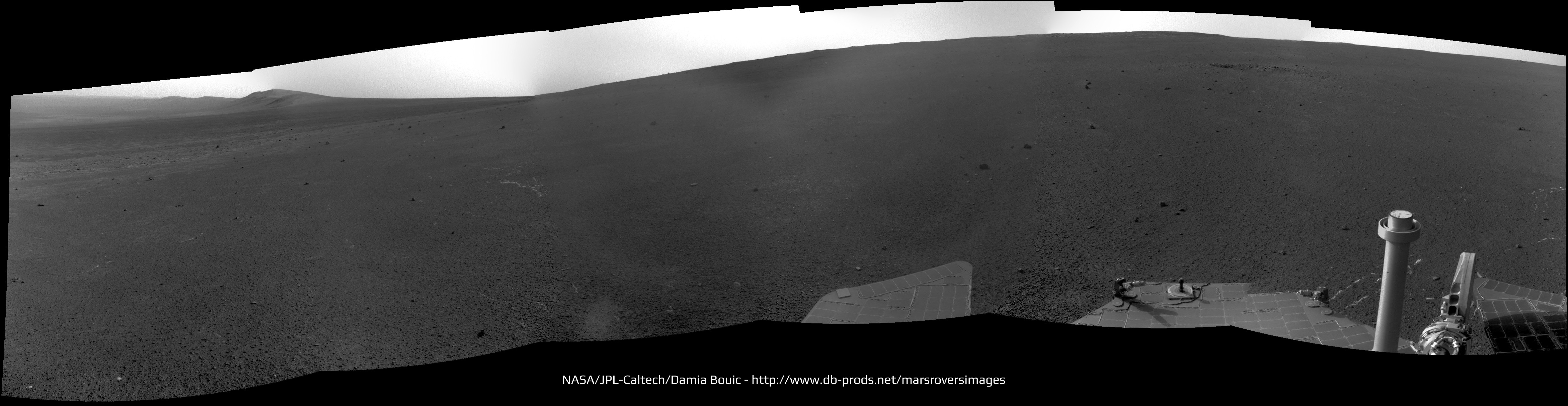
Pancam, drive "yes it's good to read drive
" direction :
QUOTE (djellison @ May 20 2013, 04:58 AM) 
You could make up a million different statistics all pretty much as meaningless as the next. ...
Exactly my point. Comparing the distance achieved by a lunar 'car' and a martian robotic rover is meaningless. The really big deal is comparing the longevity and distance achieved by Opportunity compared to design requirements and mission success parameters. I have used Opportunity as an example of outstanding reliability engineering and remote diagnosis and rectification. I stand in awe of those who designed and built her.
QUOTE (serpens @ May 20 2013, 11:36 PM)
..compared to design requirements....
JPL engineers admitted the MER's were overengineered and that the 90 day mission time was very likely to be exceeded, barring some unforseen problem. So comparing to the 90 day required time is not really a valid reference point. The main reason Sprit died was it got trapped in sand and could not tilt it's solar panels to the Sun. That of course could have happend on the first drive if fate had meant that to happen.
QUOTE (MahFL @ May 21 2013, 06:00 AM)
JPL engineers admitted the MSL's were overengineered and that the 90 day mission time was very likely to be exceeded, barring some unforseen problem
I assume you mean MER.
I can assure you - all mechanisms etc are tested to 3x the required lifetime. That's not 'over engineered' - that's called engineering margin to guarantee a good shot at reaching your requirements. It's JPL policy. It puts the bellcurve of expected failure centered beyond 90 days.
Squyres has been on record - years after landing - saying he thought maybe 120, if everything went perfectly maybe 180 sols. I'd be interested in exactly where you see JPL engineers describing MER as 'overengineered'. That's not a phrase I've ever heard them use. Required engineering margin....yes. Not 'overengineered'
Plus - the dust was STILL expected to kill the rovers very shortly after 90 sols. This paper by the late great Jake Matijevic details the expected liftspan of the rovers...
http://trs-new.jpl.nasa.gov/dspace/bitstre...9/1/02-0732.pdf
Slide 3 explicitly states that the expected useful lifespan of the rovers was 100 sols for MER-B at the 'Hematite' site ( aka Meridiani ) and 92 sols for MER-A at Gusev.
So - maybe you might find an engineer on Sol 500 saying "We obviously tested for more than 90 sols". But BEFORE launch - I challenge you to find any engineer on record stating they expected the rovers to last significantly longer than 90 days. I don't think you'll find it.
I think I may have equated 'margin' with 'over engineering'.
I still think though the team was staying with the 90/180 day thing, as the costs for a 10 year mission would not have been at the time favorably looked at by the beancounters...... . There was even conjecture at one time one rover would be turned off to save said beans
  .
.
I still think though the team was staying with the 90/180 day thing, as the costs for a 10 year mission would not have been at the time favorably looked at by the beancounters......
. There was even conjecture at one time one rover would be turned off to save said beans .
QUOTE (brellis @ May 19 2013, 11:25 PM)
Interesting stats would be long distance targets like Endurance or Victoria or Endeavor and what was the average drive length when heading towards these goals. Before embarking on the trek to Endeavor folks were doing some math about how long it would take.
btw, didn't we have a pool guessing the arrival date at Endeavor?
btw, didn't we have a pool guessing the arrival date at Endeavor?
I counted 999 Sols, Distance 21.12285 Km, 357 drives, 21.14 meters/sol 59.17 meters/drive
Paolo
QUOTE (Ant103 @ May 20 2013, 05:11 PM)
Sol 3312 panoramas
Thanks a lot Ant103 : those views are impressive in the sense they show a virgin territory yet to be explored in front of us, really devoided of any tracks and marks.
A real sence of loneliness here from your pics. This is what I call an "unknown territory" !
QUOTE (MahFL @ May 21 2013, 07:42 AM)
I still think though the team was staying with the 90/180 day thing, as the costs for a 10 year mission would not have been at the time favorably looked at by the beancounters......
And the paper I linked to proves otherwise.

I don't intend to be as precise as you are Eduardo, but Lunokhod 2's mark will be around there pending we detour to Nobby's Head as "scheduled", right?
This is to show how close we are.
Click to view attachment
This is to show how close we are.
Click to view attachment
There are some bumps on the horizon to the right. Is that Nobby head, Sutherland point or neither? What are we looking at?
We're now just starting to see Nobby's Head peeking around the side of CY. We had good views of it and Sutherland Point when we arrived at CY, but once we arrive at the south end of CY we should have a different view, since we'll be below Spirit Point/Odyssey, so Nobby/Sutherland may stick above the horizon.
QUOTE (climber @ May 21 2013, 12:50 PM)
I don't intend to be as precise....
That's great climber, just what we need to see ...for now...

Right on the edge of Cape York now, Nobby's Head/Sutherland Point ahead. 
http://www.midnightplanets.com/web/MERB/im...UP0723R0M1.html
http://www.midnightplanets.com/web/MERB/im...UP0723R0M1.html
Fasten your seatbelts and take your gravol - the drive may get a little bumpy as we cross the choppy seas of Botany Bay! 
http://qt.exploratorium.edu/mars/opportuni...JVP0733L0M1.JPG
Yes, a bit bumpy - now we have a clear view of Sutherland Point up ahead.
Phil
Yes, a bit bumpy - now we have a clear view of Sutherland Point up ahead.
Phil
This navcam shot is a treat. Level horizon with interesting destination, sundial in the foreground and dramatic lighting: it has everything. Worthy of some artistic treatment in my view.
http://qt.exploratorium.edu/mars/opportuni...W8P0733L0M1.JPG
http://qt.exploratorium.edu/mars/opportuni...W8P0733L0M1.JPG
QUOTE (ngunn @ May 24 2013, 01:19 PM)
Worthy of some artistic treatment in my view.
I agree.
Click to view attachment
This pancam mosaic was taken right after that navcam shot. The view of Sutherland Point is improving.
Click to view attachment
Click to view attachment
It's been a while since I did one of these vertical stretches - but here I think it helps to relate the horizon detail with the HiRISE image and see where we are and what's coming up. Nobby's Head is still partly hidden from view.
Phil
Click to view attachment
Phil
Click to view attachment
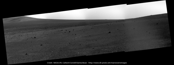
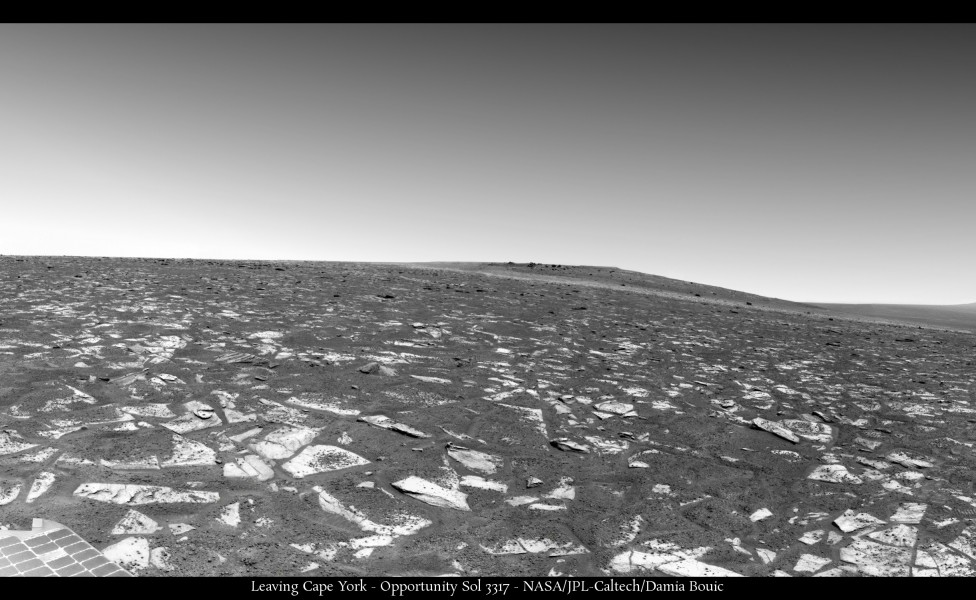
Sol 3317 panoramas The view to Sutherland Point is very good !


The view to Sutherland Point is very good !


Artefact or something real ?
Sol 3314, local time between 02:03 and 02:21 pm. 12 images with 1 min separation between the single images.
Cheers, Udo
I assume the automatic routine that makes a small window around the sun is following the sun across the frame (rather than the camera trying to track the sun), so one hot pixel in the detector will appear to move.
Phil
Phil
Phil's got it. The solar neutral density filter used in those images absorbs so much light that any star/planet/meteor/satellite would be completely invisible.
http://qt.exploratorium.edu/mars/opportuni...JVP1637R0M1.JPG
Very close to the new 'island' in Botany Bay now!
(oops! Mike just told me that one's looking backwards at Cape York just after leaving it - sorry about that, folks!)
Phil
Very close to the new 'island' in Botany Bay now!
(oops! Mike just told me that one's looking backwards at Cape York just after leaving it - sorry about that, folks!)
Phil
Nice geologic contact, there...
--Bill
--Bill
Yes, there's a bunch of Pancam images that should come down eventually mostly have come down.
Today we're treated to a lovely Navcam look back at Cape York, amongst other things. Odyssey Crater is just left of the North marker in this view.
Today we're treated to a lovely Navcam look back at Cape York, amongst other things. Odyssey Crater is just left of the North marker in this view.
http://qt.exploratorium.edu/mars/opportuni...JVP1637R0M1.JPG
Big dust devil on the slope below Cape Tribulation - or wind gust.
Phil
Big dust devil on the slope below Cape Tribulation - or wind gust.
Phil
Ooh, nice. Sol 3317.
I have noticed hints of wind activity on those slopes in the last two weeks or so, but not so obvious. Now we need to get one a bit further north!
This is a very faint DD lower down the hill on sol 3308.
http://marsrovers.jpl.nasa.gov/gallery/all...AEP0713L0M1.JPG
Phil
This is a very faint DD lower down the hill on sol 3308.
http://marsrovers.jpl.nasa.gov/gallery/all...AEP0713L0M1.JPG
Phil
Nice catch, Phil. Since the navcam imagery is only momentary, we're probably missing many gusts/dds. We had a cleaning event between 3311 and 3315 - let's hope for more.
Can you post any of those tentative gust images, Phil?
Edit - thanks!
Can you post any of those tentative gust images, Phil?
Edit - thanks!
Click to view attachment
This is the faint thingy in that image (its base is half way from horizon to bottom of frame) ... of course, the more I look at it the less I beieve it now. But comparison with other images suggests there is a faint vertical streak here. I had another one higher up in another image but can't find it now.
Phil
QUOTE (mhoward @ May 28 2013, 11:28 AM)
...Today we're treated to a lovely Navcam look back at Cape York...
Yes, a marvelous goodbye cross-section view, explaining some of the slopes on CY...
Nice catch! Are we going to get this view in pancams?
Are we going to get this view in pancams?
QUOTE (CosmicRocker @ May 28 2013, 07:26 PM)
Are we going to get this view in pancams?
Doesn't seem so at the moment, but I don't know what the future may hold. There's an albedo pan from the current position coming, but it falls just under Odyssey / CY, if that's the view you mean.
I just want to see that "marvelous goodbye cross-section view"...or that "lovely lookback" in pancams.
QUOTE (Phil Stooke @ May 28 2013, 09:54 PM)
the more I look at it the less I beieve it now. But comparison with other images suggests there is a faint vertical streak here.
It's also clearly visible in both L and R frames, so I'd say it is real.
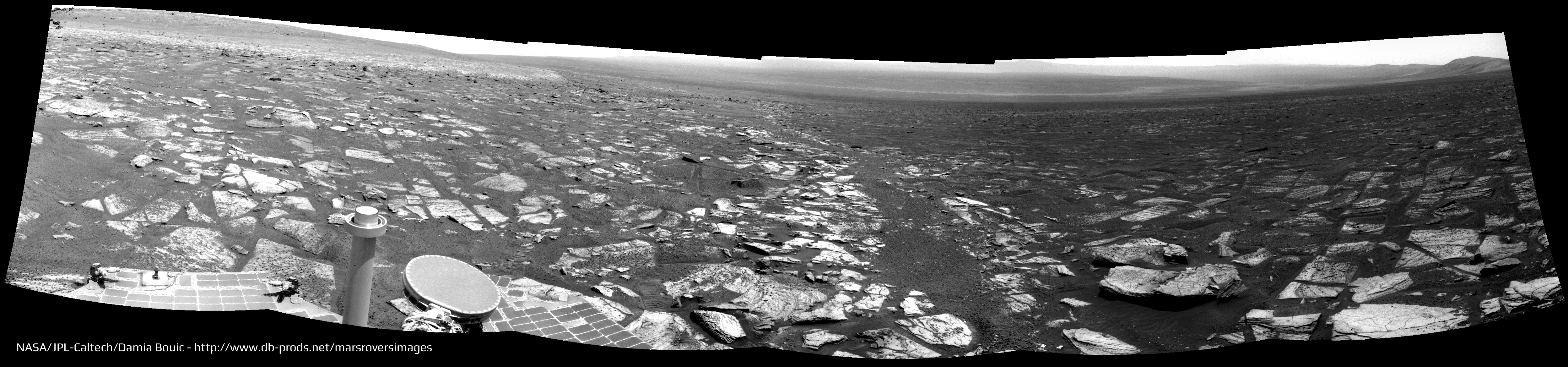
Leaving Cape York, the "big picture" (Sols 3317 & 3318)

And Sol 3317 view of Endeavour.
Maybe it's Postcard time ?
I'm wondering about making a colorized version…
And Sol 3317 view of Endeavour.
Maybe it's Postcard time
?I'm wondering about making a colorized version…
Really nice mosaics! One thing they show clearly is how the hills all sit on a slope so the western side of the hill is nearly level and the eastern side is steeper. Remember when we approached Cape York and it was so hard to see it from a distance. For that reason it was easy to get 'up' onto the ridge of Cape York. But looking further south suggests the same will be true at Solander and even Cape Tribulation. They are steeper than Cape York, certainly, but it certainly looks like we can get all the way to the top of any of those hills from the west side.
I have been looking at the hills in HiRISE to see if the range of features visible at Cape York is also available further south. I especially hope to see networks of large filled cracks like we saw on Shoemaker Ridge but did not investigate at the time. So far I have not noticed anything like that, but maybe I have not looked at the best images yet.
Phil
QUOTE (climber @ May 21 2013, 08:50 PM)
I don't intend to be as precise as you are Eduardo, but Lunokhod 2's mark will be around there pending we detour to Nobby's Head as "scheduled", right?
Is there a comprehensive source of Lunakhod 2 pictures? I would love to see a movie taken by Lunakhod 2's "hazcams" as it drove over the 37 km. I guess that most probably these analogue "hazcam" views are lost. I have seen some of Lunakhod's pretty "navcam" views of hills and piles of rocks. However, I have never found more than about 20 different Lunakhod 2 photos.
This site seems to be the most comprehensive resource out there as far as I'm aware.
http://www.planetology.ru/panoramas/lunokhod2.php
http://www.planetology.ru/panoramas/lunokhod2.php
The TV images used for driving ('hazcams') were recorded on tape. When the Soviet Union fell apart the tapes were taken home by one of the participants who probably hoped to sell them at some point. That never happened and the tapes were recovered a few years ago. So far they have not been read and the images recovered, as far as I know - if they have nothing much has been done with them. But a lot of work is going on in this area now. I have had this from the people involved, especially Kira Shingareva.
Phil
Phil
QUOTE (Phil Stooke @ May 30 2013, 04:48 PM)
I have had this from the people involved, especially Kira Shingareva.
Phil
Phil
Who's here on the same picture as yourself Phil, right? http://www.google.fr/imgres?um=1&sa=N&...9,r:7,s:0,i:105
Yes, third from the left.
Phil
Phil
Yes; approximately 75m SW toward Sutherland Point on sol 3323. And stop calling us Shirley.
Adding: Here's an Navcam anaglyph view from the sol 3323 location. We should be right next to that small crater along the way on the route map, so the next couple Navcam images to come down might be interesting.
Adding: Here's an Navcam anaglyph view from the sol 3323 location. We should be right next to that small crater along the way on the route map, so the next couple Navcam images to come down might be interesting.
And there it is: the small crater to the west on sol 3323. For a minute I thought it was not there. Very hard to make it out except in stereo; not what I was expecting to see!

MERBSol3323AnaglyphViewSmallCrater on Flickr
MERBSol3323AnaglyphViewSmallCrater on Flickr
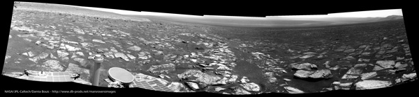
Sols 3317 & 3318 panoramic is getting full circular
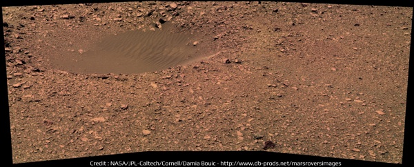
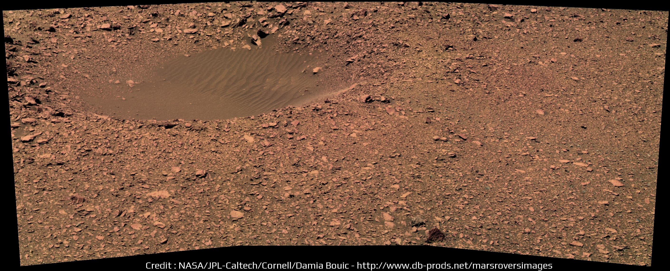
A small crater met at Sol 3314 :
And the last panoramas, Navcam and Pancam, from Sol 3323. Clearer view on Sutherland
A small crater met at Sol 3314 :
And the last panoramas, Navcam and Pancam, from Sol 3323. Clearer view on Sutherland


This is a "lo-fi" version of our main content. To view the full version with more information, formatting and images, please click here.