The "missing piece" of the Albedo Pan hasn;t arrived so I did a quick cylindrical pan and reprojected it as a Polar pan.
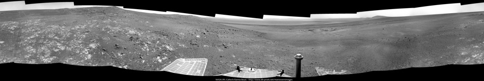
Sol-3342, p2297, L2 Albedo Pan. North approx up:
--Bill
Full Version: Heading south from Cape York
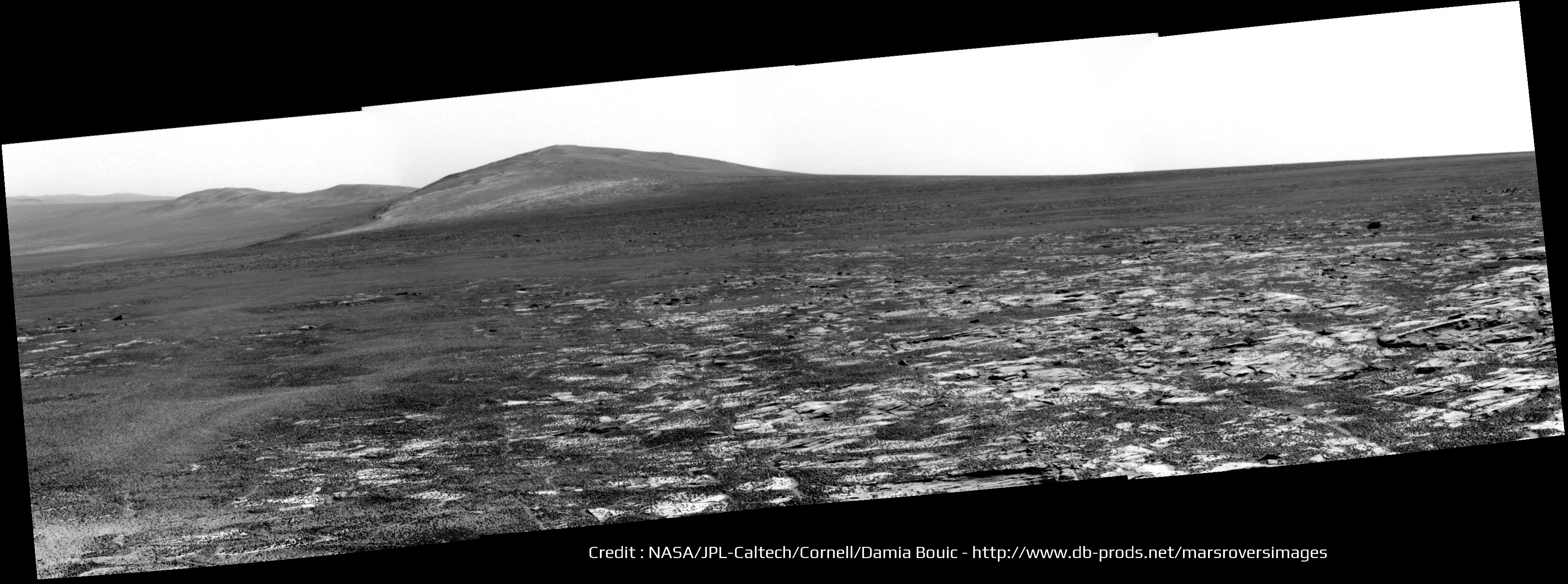
Practicing a bit with polars, here is a 3x1 Navcam from Sol-3442. North approximately up.
And we have several interesting Pancam sequences in the pipeline...
--Bill
And we have several interesting Pancam sequences in the pipeline...
--Bill
My best "TLAR" guesstimate of where Oppy is on Sol-3345:
--Bill
--Bill
I think the last two sites, 3342 and 3344, are slightly south of those positions. Here're the two vertical projections I just made to update my route map.
Click to view attachment Click to view attachment
Click to view attachment Click to view attachment
QUOTE
slightly south
I think so, too. That crater to the south of the track is the larger of the two and is next to that "low hill" that confused me once again. 
It's not as prominent as it looks from HiRISE-- some of the deceptive relief may be emphasized by albedo features.
The L257...Pancam sequences are still on the way, the L2/R2 stereo pairs are starting their way down.
Berrio_Crater_2x1_L257R2 Sol-3044
Berrio_bench_L257R2 "
Carlindi_half_L257R2 "
Numbat_L257R12467 Sol-3344
Hornby_L257R2 "
Mulga_L257R12467 "
Chameleon_L257R2 "
Jacky_L257R12467 "
The current site is that "updip, low in the sequence" area we were hoping for. Oh joy!
--Bill
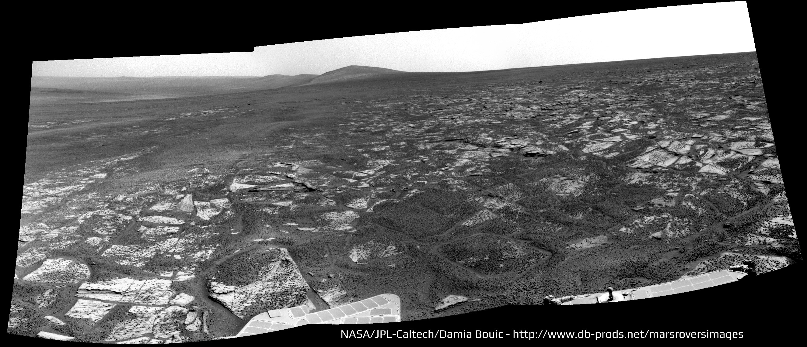
My take on this Sol 2244 & 2245 full 360 Navcam pan

Nice pan - here's my circular version. Let's see if we can locate those names on it. (we had a Numbat 2 sols ago, and a Berrio crater near Whim Creek... seems a bit odd)
Phil
Click to view attachment
Phil
Click to view attachment
Right. The "Berrio Crater" (and -Bench) were Sol-3044. Those hid nicely in the Sol-3344 image list... 
--Bill
--Bill
QUOTE (Phil Stooke @ Jun 22 2013, 06:23 PM) 
Let's see if we can locate those names on it.
They were shot on the same sol but at the previous site, the one from sols 3342-3344 with ID "C200". Most, if not all of them, are on today's downlink.
It's not that bad. There are some 20 post-Esperance named sites and of these 8-9 are the current crop. The problem is keeping up with things in the long run.
--Bill
--Bill
Wowsers! Looks like we're down on the plains again:
http://www.midnightplanets.com/web/MERB/im...MP0703L0M1.html
Phil
http://www.midnightplanets.com/web/MERB/im...MP0703L0M1.html
Phil
Looks like she's folded her tent and is headed Southwardish.
And we never found out about Gibber_Earless...
--Bill
And we never found out about Gibber_Earless...
--Bill
"There are some 20 post-Esperance named sites and of these 8-9 are the current crop. The problem is keeping up with things in the long run."
That's what I am trying to do, to record, maybe not all these names, but as many as is feasible, and locate them on maps. Earlier ones come out of the Analyst's Notebook, but I try to keep up with current ones as well. But it's a lot of work!
Phil
That's what I am trying to do, to record, maybe not all these names, but as many as is feasible, and locate them on maps. Earlier ones come out of the Analyst's Notebook, but I try to keep up with current ones as well. But it's a lot of work!
Phil
It is a lot of work. Not only the identifying the named sites, but also locating them on polar reprojections of Nav- and PanCam panoramas (if available) and thence to HiRISE images and HiRISE-derived maps. As you well know. The BIG problem is not so much the named sites, but the multitude of "Foreground Quarter" and "Clast Survey"and "one-shot drive-by" images. Even innocuous images like FHazCam and RHazCam shots are useful for soil texture info.
It never ends. Thank goodness...
--Bill
It never ends. Thank goodness...
--Bill
Here is a best guesstimate of where Oppy was on Sols-3342-3344-3346:
The graben-- fault block-- that she passed East of on exiting Nobbys Head bench may show up on the azimuth 270* partial Navcam pan.
--Bill
The graben-- fault block-- that she passed East of on exiting Nobbys Head bench may show up on the azimuth 270* partial Navcam pan.
--Bill
Here is a 5x1 pano of that Sol-3346 Navcam sequence with a cropped and rotated portion of the above location image, showing the suspected graben/fault block. Note especially the unusual textures of the weathered rock in the "fault plane".
--Bill
Added: A 4x1 pano of the above sequence (left the fifth "northmost" panel off) showing the suspected fault (but not as well as I'd hoped).
--b
--Bill
Added: A 4x1 pano of the above sequence (left the fifth "northmost" panel off) showing the suspected fault (but not as well as I'd hoped).
--b
Sol 3346 panoramics :


Now these sites are going to be interesting:
Gibber Earless
http://www.midnightplanets.com/web/MERB/im...3P2597R2M1.html
Signal Head
http://www.midnightplanets.com/web/MERB/im...3P2391R2M1.html
Got stereo pairs, waiting for the color imagery.
--Bill
Gibber Earless
http://www.midnightplanets.com/web/MERB/im...3P2597R2M1.html
Signal Head
http://www.midnightplanets.com/web/MERB/im...3P2391R2M1.html
Got stereo pairs, waiting for the color imagery.
--Bill
QUOTE (Ant103 @ Jun 24 2013, 11:49 AM)
Sol 3346 panoramics :
Love it! And the view will improve drive after drive.
This is a cleaned-up view of Solander Point (and Cape Tribulation peeking over its shoulder) - cleaned up by merging the two most recent pancam images to improve signal to noise (mostly JPEG artifacts). There should be plenty of interesting things to look at - I like the long continuous light-toned stratum at the top of the brighter area. (Hopefully it's not just a big dust drift!)
EDIT - see following post - Bill's right of course - looks like the Meridiani plains, AKA Burns Formation, slope upwards a bit where they are plastered onto the tip of the point. But we presumably have to go higher up to get the slopes we need plus the old Endeavour rim material.
Phil
Click to view attachment
The bright area is the usual Meridiani Overlap/Bench that crops up at the foot of the hills and the continuous stratum may be simply outcrops superimposed along the line of sight. Here is a cropped and inverted ("North" is down) HiRISE image of the target area:
--Bill
--Bill
It's very nice to have the view ahead and the view from overhead consecutively in the last two posts. Even better would be if someone could identify a few key points in both images to help the rest of us get our bearings. I have to admit I'm struggling a bit to find sure identifications when it comes to the details.
Good idea. It's hard to tell "Who's on First or What's on Second" without a scorecard.
First: An annotated and clarified image from Arvidson, et al.
Second: Phil's "solander_cleaned" image and a HiRISE image, shamelessly annotated.
"HTH"
--Bill
First: An annotated and clarified image from Arvidson, et al.
Second: Phil's "solander_cleaned" image and a HiRISE image, shamelessly annotated.
"HTH"
--Bill
QUOTE (Bill Harris @ Jun 25 2013, 12:39 AM)
First: An annotated and clarified image from Arvidson, et al. Second: Phil's "solander_cleaned" image and a HiRISE image, shamelessly annotated. --Bill
What an interesting geological site ! I hope they will have some time left to climb a little, even up to Solander Point if they can...
The view from up there on the crater and surrounding plains should be gorgeous ! Maybe that the rim of Bopolu crater on the south-west will be also visible from this new vantage point
Click to view attachment
Bopolu Crater, as seen by Opportunity, Sol 2195
Special treat today: at least part of the sol 3348 drive direction mosaic is in stereo color (L27R12).
"Hello and goodbye. I missed the chance to swallow you but never mind."
Here is a registered and merged combination of the L2 and R2 Drive Direction images from Sol-3350. This shows the Eastern slope of Solander in the vicinity of the "Bluffs" that I identified earlier in Post#223. In the foreground is the light-toned, and blocky, Meridiani Onlap unit. Above it can be seen distinct layers and even ledges of the basal part of the Endeavour Rim unit. This low part of the section has a good chance of having been weathered under wet and warm conditions (say "clay").
Don't zoom in beyond 150%, I didn't do a lot of work here prettyfying it...
--Bill
Don't zoom in beyond 150%, I didn't do a lot of work here prettyfying it...
--Bill
QUOTE (Bill Harris @ Jun 24 2013, 11:39 PM)
Good idea. It's hard to tell "Who's on First or What's on Second" without a scorecard.
...Phil's "solander_cleaned" image and a HiRISE image, shamelessly annotated.
...Phil's "solander_cleaned" image and a HiRISE image, shamelessly annotated.
I think your rightmost arrow points to a feature on Tribulation - check out my old ID here.
QUOTE (mhoward @ Jun 25 2013, 01:44 PM)
Special treat today: at least part of the sol 3348 drive direction mosaic is in stereo color (L27R12).
That was my request. Red gives more contrast while Blue has sharper images. I wanted to see if Blue would give us more range data, or better range data farther from the rover to be able to extend our drives. The outcome is that yes, Blue gives range data at a larger distances but it is quite noisy so we have sparser data.
Paolo
Very interesting. Is there any way you could combine red and blue? I ask for purely selfish reasons, because false-color drive direction stereo pairs are pretty much my favorite thing ever
Likely yes but now with a shoestring budget any development is tough to justify. Whenever we can we use both when we assess the terrain in front of us but manually, there is no automation behind it.
Paolo
Paolo
Bill, post 228. It sure looks like strata but we have been fooled by Endeavour many times and Solander is almost certainly as big a dog's breakfast as Cape York. I think we are still in a 'suck it and see scenario'.
May well be Pareidolia in action. There are so many wild-eroded flutes on that surface that they may be looking like lineations at this low viewing angle.
We'll see what we see when we see it...
--Bill
We'll see what we see when we see it...
--Bill
QUOTE (fredk @ Jun 27 2013, 12:34 PM)
I think your rightmost arrow points to a feature on Tribulation - check out my old ID here.
Probably does-- I'll be sure to revise it in the next edition.
According to metadata, Opportunity drove almost 120m south on sol 3351. Nice!
Nice email sent to the Opportunity team from John Callas after the Sol 3348 drive.
QUOTE
Dear Team,
Over ten years ago, we struggled over whether the mission success distance requirement for the Mars Exploration Rovers should be 500 meters or 600 meters. The more ambitious requirement of 600 meters was chosen. When we landed, we fantasized how wonderful it would have been to have had multi-kilometer capability to reach the Columbia Hills with Spirit, knowing the rovers were designed for only 1 kilometer. We reached the Columbia Hills. After exploring Endurance Crater with Opportunity we ventured to imagine getting to Victoria Crater, requiring more than 10 kilometers of odometry. We reached Victoria. The problem with dreams is that when you achieve them you have even grander ones. We dreamt of now doubling Opportunity's odometry to reach the more ambitious target of Endeavour Crater. We fulfilled that dream. As ever more ambitious targets were achieved we set our sights on establishing the off-earth driving record. That record is held by the Soviet Lunokhod-2 rover from 1973. For four decades that record was 37 kilometers. Recently, with image survey data from the Lunar Reconnaissance Orbiter (LRO), the Lunokhod record is estimated to be father still. Whatever that record is, we know we are closing in on it. Today, with the Sol 3348 drive of nearly 100 meters, Opportunity's odometry is now 37,028.11 meters, exceeding 37 kilometers ! Clearly this rover and mission are in the Pantheon of great missions of exploration. These outstanding accomplishments are wholly due to your extensive contributions and unbridle dedication. Thank you for that. Well done. And, keep going!
Sincerely,
John
Definitely. And I would like to highlight his sentence "Clearly this rover and mission are in the Pantheon of great missions of exploration".
At this pace we might make "landfall" in two or three weeks.
QUOTE (mhoward @ Jun 28 2013, 05:09 PM)
According to metadata, Opportunity drove almost 120m south on sol 3351. Nice!
At this pace we might make "landfall" in two or three weeks.
Part of the current HiRISE image of the Oppy route between Nobbys Head and Solander suggests a set of N-S lineations that appears to be offset at a point midway between the two sites. I wonder what the nature of these lineations is? And what is the nature of the area where they are apparently offset?
Another of the Mysteries of Mars...
--Bill
Another of the Mysteries of Mars...
--Bill
Inward slumping of parts of the crater rim are evident on the far side of Endeavour crater so perhaps this is the eroded remains of something like that? The Noachian layers seem to be dipping downward into Endeavour. Was that the case before the Endeavour impact or is it a product of that impact in some way? Questions, questions . .
Endeavour is pretty much on the threshold size for a complex crater so the eastern rim features could be where final crater marginal collapse zones caused terracing with associated faulting. The original rim would have been many hundreds of meters high so there could also have been some rebound, slumping and fracturing. The Endeavour rim is so worn down and over-run that it is difficult to determine an accurate footprint of the final crater.
What impresses me is that the Meridiani-age sediments (which we are now presumably traversing) were deposited long after the Endeavour event with the crater rim eroded down to a nubbins and the ejecta blanket eroded away or covered. The idea that the crater rim could still be structurally (tectonically??) active after all these aeons is almost incomprehensible. Not only do we have the lineations in the Meridiani-age sediments we also have that offset at the central point which implies faulting or slumping. And the term "Meridiani-age sediments" may be open to reinterpretation-- they may be the basal Burns Formation or even earlier. The gross characteristics are similar to the Burns: thinly-laminated to massive, fine-grained with concretions. We are not sure if the concretions are Blueberries, Newberries or Boysenberries.
A mystery that could be wrapped up in a enigma...
--Bill
A mystery that could be wrapped up in a enigma...
--Bill
Speculation: If the older buried rock along the rim has a lot of clays, expansion and contraction due to variable moisture content at some depth could generate large-scale cracking -- a periodic wetting and dessication cycle. The rock type boundaries of the rim would entrain the cracks.
Montmorillanite on Mars?
Montmorillanite on Mars?
At Endeavour we are trying to interpret events that took place roughly 4 Ga ago in a far more energetic environment. The dating is rubbery and the elapsed time between the Endeavour impact and the Meridiani sediment event is unknown. While we have come to love the traverse surface of laminated sulphate sandstone littered with hematite concretion lag can we make any correlation to the Burnes formation which is defined as the 7 odd meter stratigraphic section explored in Eagle crater and Endurance? The big crater roadcuts of Endureance, Erebus and Victoria were at the top of a mound and we have descended a fair way with limited analysis of the couple of crater roadcuts we passed on the way. The Botany Bay surface looks different, but does this reflect enhanced erosion from channelling of wind from the crater or something else entirely?
Amen, brother. The surface started to look different when we rolled off of the Cape York bench and continues to provide much amazement. I see that we are still getting the "clast survey" and the "systematic foreground" sporadically in the daily offerings but we'll need to go mine the PDS in a few months. Still, the surface is fascinating to look at as we roll along.
Here is a crop of a HiRISE RED channel image of the Western Rim of Endeavour. This is just off the possible route of Oppy and in in the general vicinity of the supposed offset of the lineations that I noted a couple of days ago. Scale is 25cm/pixel and I've added a scale bar. Take a look and see what you can see. Bear this in mind: this is a red channel image, so reddish areas will show as light-toned, and bluish (ie, basaltic or hematitic signatures) will show up as dark-toned.
Have fun...
EDIT:Oops. Got a decimal off on the scale bar-- should be 50m, not 5.0
--Bill
Looks like another drive on sol 3353 - don't know how far yet, but we are covering the distance pretty fast now.
Phil
Phil
30m, according to the metadata.
QUOTE
expansion and contraction due to variable moisture content at some depth could generate large-scale cracking
I've not heard of that happening. Most likely they are related to stress-relief, but why do they cut through younger rocks and what are they more-or-less parallel to the rim structure?
At any rate, unusual rocks from the RHazcam, Sol-3553, presented in x-eyed stereo. Cut, paste and rearrange the pair as you see fit.
And, in the pipeline, a slew of MIs from Sol-3552. Yay.
--Bill
Perhaps we shouldn't put too much emphasis on the orientation. There are similar features just to the east of Cape York visible in the attached image with varying orientation. As far as I know we don't have a real consensus on the cause of Anatolia Trough do we?
I've been admiring that terrain East of CY for years now.
The orientation and alignment of the lineations with the (remnant) structural features of the Endeavour rim is too strong to be considered casual. My intuition says that there may be a connection, but I'm always looking for another interpretation.
I don't know what current thought is on the Anatolia features. I feel that years ago the interpretation was karst: solution of the soluble keiserite-cemented sandstone along fractures and joint systems. And that is my continuing interpretation. I remember that Phil Stooke has some polar projections of MER-B Pancam panoramas of the type Anatolia feature near Eagle (Fram??) crater from the early Sols of Oppy.
Anyways, here is an annotated image of the Eagle-Endurance Crater region, with the Anatolia features delineated in Red, and the boundary between the Smooth sandy plains and the Rippled sandy plains to the South. I did this in 2005-2006 and the image is named "MER_DIMES_anatolia"; I don't recall where I got that base image.
--Bill
This is a "lo-fi" version of our main content. To view the full version with more information, formatting and images, please click here.