eoincampbell
Jul 7 2013, 03:18 PM
QUOTE (ngunn @ Jul 6 2013, 11:09 PM)

There is a nice contoured perspective view on p.51 of this PDF:
http://www.google.co.uk/url?sa=t&rct=j...d2k&cad=rjaP.41 I believe, great article, the last half of the "saddle" does imply a slight climb so I agree with Phil's original assertion... The views from Solander looking back on her tracks will be spectacular...
fredk
Jul 7 2013, 05:50 PM
There's also a contour map showing the route to Solander Point
here.It's clear from all of this elevation imagery that heading to the northernmost tip of Solander Point would take us downwards considerably - maybe 30-35 metres relative to Nobby or our exit point on CY. That explains the idea of driving onto Solander from the west, so we don't have to do as much climbing.
Phil Stooke
Jul 7 2013, 06:10 PM
I had one of those epiphany things. You know, the way you do. I got onto that 'climbing' idea because looking back we seem to look obliquely onto the Nobby's Head 'pavement' as if slightly above it. But if you crawl around a saucer (tricky to do, but I'm just saying IF you did) and look back you would see that, not because you're higher but because you are part way round the sloping surface. And here, we are doing exactly that. OK, I admit it - we are at the same elevation pretty much, but viewing Nobby and Cape York very slightly sideways as we head south.
Another drive today. I can't tell how long yet.
Phil
ngunn
Jul 7 2013, 07:24 PM
QUOTE (Phil Stooke @ Jul 7 2013, 07:10 PM)
I had one of those epiphany things.
https://www.google.co.uk/imgres?imgurl=http...AwBA&iact=c
mhoward
Jul 7 2013, 07:39 PM
About 42m SSE on sol 3360 according to the metadata - but she was up at 5AM to do some very cool imaging of Phobos and Deimos

Bill Harris
Jul 7 2013, 08:13 PM
QUOTE
very cool imaging of Phobos and Deimos
Yes.
http://www.midnightplanets.com/web/MERB/latestImages.html"Posted Sol 3360.78"
--Bill
(along with Nav- and Pancam images with possible landmarks for pinning down the location of the ole girl. The terrain she's on has so much fine detail but a certain blandness for matching up with HiRISE features.)
tolis
Jul 7 2013, 11:13 PM
UNNECESSARY QUOTING REMOVED -ADMIN
Is that marsshine I detect on the upper part of Phobos' trail?
Phil Stooke
Jul 7 2013, 11:25 PM
"The terrain she's on has so much fine detail but a certain blandness for matching up with HiRISE features.)"
Here's one match:
Click to view attachmentPhil
fredk
Jul 8 2013, 04:50 AM
QUOTE (tolis @ Jul 7 2013, 11:13 PM)
Is that marsshine I detect on the upper part of Phobos' trail?
I'd say so. Here's an average of the two registered frames to reduce jpeg noise, with 2x zoom:
Click to view attachment
Phil Stooke
Jul 8 2013, 07:28 PM
Bill - replying to your question in the route map thread... I'm have great difficulty reconciling the positions here. My current preference is between yours and the one I posted. I will be working to figure it out soon.
Phil
mhoward
Jul 8 2013, 08:22 PM
I've just created an automatically-updated web index of
Opportunity's Pancam observations based on the Pancam Database. This has a couple features I hope will be helpful: it includes all the Pancam observation descriptions from the entire mission (excluding extremely repetitive tau measurements and calibration target images), so it's easy to search for a name. And it links to the first available image for each observation, or if the image is not available yet, it lists the first thumbnail image id. There's also an index for
Spirit.
<moderator hat on>As a side effect, I'm hoping that this can help reduce unnecessary discussion of what is or isn't in the database, not increase it.</hat>
Bill Harris
Jul 8 2013, 08:42 PM
QUOTE
I'm have great difficulty reconciling the positions here...
Me too. On the "misc_scribblings" layer of my Route Basemap I have my ??position, your ??position and as couple of other guesses eraseably noted. We'll just need to get to "known landmark" to reckon where we are, and backtrack from there.
As an aside, we now have a fairly good Navcam pan for Sol-3355, and it looks like that position is quite good.
--Bill
fredk
Jul 9 2013, 12:36 AM
QUOTE (mhoward @ Jul 8 2013, 08:22 PM)
I've just created an automatically-updated web index of
Opportunity's Pancam observations based on the Pancam database.
Wow, that's nice. Thanks for putting that together.
monty python
Jul 9 2013, 07:11 AM
QUOTE (fredk @ Jul 8 2013, 07:36 PM)
Wow, that's nice. Thanks for putting that together.
YES! Now a simp like me can follow oppy.
Phil Stooke
Jul 9 2013, 02:12 PM
That's really useful!
Phil
mhoward
Jul 9 2013, 03:02 PM
Thanks for the comments. I made a couple changes this morning, to remove some broken links and note the number of images in each observation. That will probably be all for a while, but the page will continue to update on its own.
Phil Stooke
Jul 9 2013, 09:18 PM
Another drive on 3362 - but I'm not having any luck locating the current position yet. Map update when I do.
Phil
mhoward
Jul 9 2013, 09:43 PM
About 88m just east of south, if that helps. I'm going to guess she drove over and just past the slightly dark eroded craterlet, but I don't see much to go on yet.
Edit: actually I think I can see the eroded craterlet in stereo in the sol 3360 drive direction mosaic. Based on that, I think she drove just east of it. That would mean some of the previous map placements might be a bit off. But you know, really hard to say at this point.
Phil Stooke
Jul 9 2013, 11:14 PM
I'm thinking it may be visible in the front (= rear-facing) hazcams. If that feature is the crater we can get a good position... but not sure yet. -EDIT - no, probably not. Another edit - well, maybe - this is what I'm pondering:
(IMAGE DELETED - OOPS)
I must have taken the pic from a different sol by mistake.
Phil
Bill Harris
Jul 10 2013, 03:59 AM
Phil, I don't think that 1F426484156EFFC4GFP1215R0M1 is a Sol 3362 image (3362_fhaz.jpg).
Phil Stooke
Jul 10 2013, 11:06 AM
I guess not - I was sure I took it off that page but now I don't see where I got it from. I'll take it out.
Phil
mhoward
Jul 10 2013, 07:58 PM
The Sol 3363 drive was about 59m 15º east of south, according to the metadata.
Bill Harris
Jul 11 2013, 01:04 AM
Oppy has been located about as closely as can be with the paucity of landmarks, but I think we're close. I still could barely see that mystery crater or the scoured area, both those features are shallow and easily blend in with the topography. Based on the target area at Solander, the route should lie between consistently S15E and S20E unless we have to divert around obstacles. Which might happen in about 200m where Oppy will need to cross those fractures and a couple of small dunes. We'll know in the next 2-3 drives.
--Bill
kenny
Jul 11 2013, 01:23 PM
LRO measurements suggest Lunokhod 2 actually travelled 26 miles (42 kilometers) in 1973, rather than the 23 miles (37 kilometers) on the lunar surface. So it looks like Opportunity's claim on the off-Earth driving limit has some way to go.
Lunokhod 2 drive distance revision
Ant103
Jul 11 2013, 07:32 PM
I'm back here for some panoramics, in these crucial times (no no, I don't overplay

).
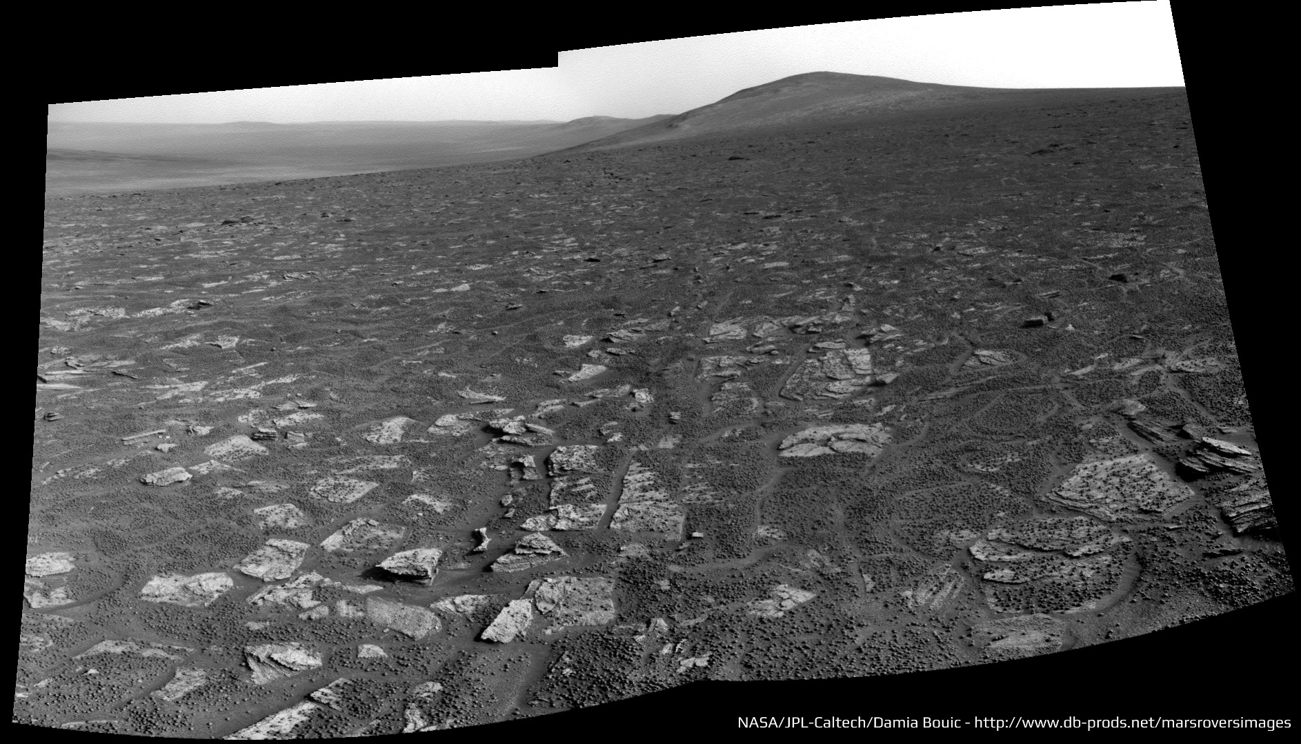
Sol 3360 :

Sol 3362 :

And the better, the Pancam view. A LOT more details than in the previous sols


Sol 3363, fascinating view :

Oppy could reach her arm and litteraly touch Solander Point
RoverDriver
Jul 11 2013, 09:00 PM
QUOTE (Ant103 @ Jul 11 2013, 11:32 AM)
...
Oppy could reach her arm and litteraly touch Solander Point
I think an arm 470 meter long would be quite difficult to control ... but i get your point. These mosaics are quite cool. I need to learn how to do it. I'm spoiled that I find them ready-made.
Paolo
mhoward
Jul 11 2013, 09:23 PM
According to the metadata, another 120m about 18º east of south on sol 3364. Your drive, Paolo?
Bill Harris
Jul 12 2013, 12:41 AM
Looks like Oppy may have made that Eastward jog a couple of drives early:
NextDrive Direction:
http://www.midnightplanets.com/web/MERB/im...0P2405L2M2.htmlAnother 120m drive would have gotten her into brambles for that jog.
And an interesting set of HazCams-- a set of four, with a 90degree turn-in-place, making a 360deg HazCam Pan. Your doing, Paolo?
--Bill
Bill Harris
Jul 12 2013, 03:14 AM
And here is another set of images made from stereo pairs of HazCam images. These are east-facing FHazcam images and west-facing RHazcam images from Sol-3363 that I was trying to process to show location landmarks.
First I made a fisheye lens correction to correct the inherent distortion, then cropped for the mid- and background and resized for a 3x vertical exaggeration. I then aligned the images to make x-eyed stereo pairs and enhanced the image pair to bring out detail.
The first image is the east-facing set, and has a certain Dali-esque character to the crater bowl and far rim. The midground really has a nice trendy travertine tile kitchen flooring appearance while the background has the appearance of a nice polished and sealed layered sandstone.
The second image is west-facing and shows Botany Bay going boringly out to the Meridiani plain. BUT if you will look at the horizontal level of the plain (highlighted in yellow) compared to the surface of Botany, you can see that botany slopes upward to the left (South) which suggests that Oppy is indeed now on the upward curve of the saddle.
--Bill
Phil Stooke
Jul 12 2013, 02:25 PM
This looks like a reasonable match between a reprojected Navcam pan on 3364 and the HiRISE image (ESP_018701_1775).
Phil
Click to view attachment
fredk
Jul 13 2013, 03:16 PM
QUOTE (Bill Harris @ Jul 12 2013, 01:41 AM)
Looks like Oppy may have made that Eastward jog a couple of drives early
It looks like there will indeed be a jog to the east as it looked from the drive direction pancams - from
this blog post:QUOTE
there is a desire to do a short side trip to the east to investigate an anomaly detected from orbital remote sensing. This means descending into the crater wall a hundred meters or so before turning south to intercept Solander Point. The anomaly looks texturally different as well as spectrally different.
Time to get your speculating hats on - who wants to try pointing to the "anomaly" on an orbital view?
fredk
Jul 13 2013, 06:48 PM
I didn't recognize the dunes in this new shot when I first saw it:
http://qt.exploratorium.edu/mars/opportuni...2M1.JPG?sol3364Then I realized that's how much our view has changed during the drive. Here's an animation to show our changing view of the dunes since we left the Matijevic Hill area:
Click to view attachmentWe should get a much better view still once we climb up Solander a ways...
Bill Harris
Jul 13 2013, 07:18 PM
QUOTE
It looks like there will indeed be a jog to the east as it looked from the drive direction pancams - from this blog post:
http://www.nmnaturalhistory.org/sol-3363-july-10-2013.htmlThat is what I was thinking. Larry Crumpler is a good Geologist, making excellent interpretations from the bits of Puzzle Pieces that drift through. I liked the paper/PDF he did on the Geology of Cape York.
QUOTE
who wants to try pointing to the "anomaly" on an orbital view?
Here it is. I'm still a bit unsure of where Oppy is, and when or not the "sol-3364 dd" took place. Pareidolia reigns supreme, and landmarks are like cloud-figures.
First is a polar pan from the Sol-3364 Drive Direction. And next is a crop from the HiRISE base map in use, showing a couple of possible locations and a lot of interesting landforms.
Have at figurin' out where we are. I'm gonna hold it til we see a Howard Johnson's Sign...
--Bill
fredk
Jul 13 2013, 08:58 PM
Beautiful gust from back on 3309 when we were just starting the drive south:
http://qt.exploratorium.edu/mars/opportuni...0M1.JPG?sol3309
mhoward
Jul 13 2013, 11:04 PM
The sol 3366 drive was about 8m due east to do the second part of a long baseline stereo mosaic, and then roughly 69.5m around 40º south of east.
I never do this, and don't plan to do it in the future, but
here's my estimate on where she is. It seems to line up with the local landmarks - but again the local landmarks around here are quite subtle, and we don't have many images yet, so who knows.
Ant103
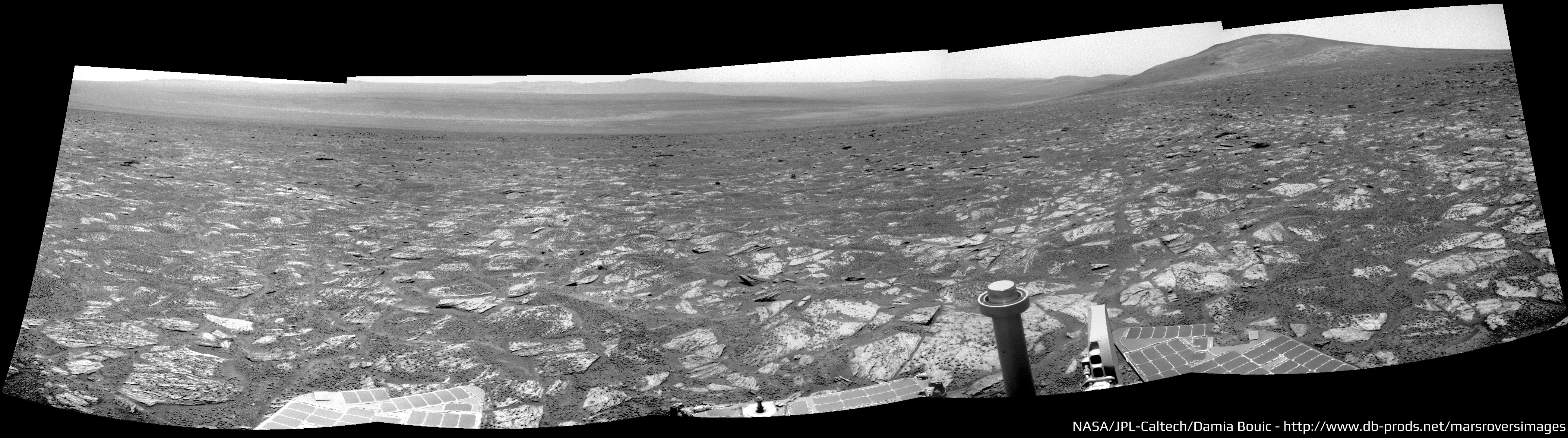
Jul 14 2013, 12:46 PM
Sol 3364 Navcam pan, showing a wide part of Endeavour

Phil Stooke
Jul 14 2013, 11:58 PM
This is an attempt to match the half-pan from 3366 with HiRISE, from Mike's post just above. Now we are getting quite a good set of matching features, and having half a pan instead of two images makes it much easier.
The black dot is my estimate - just a bit further onto the high albedo patch beyond the obvious linear boundary than Mike's was. This isn't 100 m downslope, though - maybe the darker area beyond this high albedo strip is the actual target.
Phil
Click to view attachment
mhoward
Jul 15 2013, 12:07 AM
Yep - I think you've got it there, Phil. Very challenging though.
Bill Harris
Jul 15 2013, 03:13 AM
Here is one of those fractures that Oppy has been crossing on this leg of the traverse. Sol-3366, x-eyed stereo, take from near the point where Mike estimated the rover location in Post 335. The rock in the upper left background is Phil's "B" in Post 337.
I'd suspect that they are looking at these light-toned areas for CaSO4 fracture fills in this fractured zone. Or this jog might be a simple course adjustment to slide onto Solander easily.
--Bill
Ant103
Jul 15 2013, 05:15 PM
fredk
Jul 16 2013, 11:37 PM
Another eastwards (or southeastwards?) drive on 3369 and again a new southeast-facing drive direction pan:
http://qt.exploratorium.edu/mars/opportuni...2M1.JPG?sol3369
mhoward
Jul 17 2013, 01:16 AM
About 77m 11º south of east.
Adding: there's a clearly-defined craterlet just east of us, so this one isn't hard to pin down.
Also adding: I'm starting to wonder if we should change the topic to "Heading East from Solander Point". (joke)
Ant103
Jul 17 2013, 10:56 AM
Sol 3369 panoramics, again centered on Endeavour.


Phil Stooke
Jul 17 2013, 02:28 PM
Despite Mike's confident assertion "there's a clearly-defined craterlet just east of us, so this one isn't hard to pin down.", it is not as easy as you would like it to be.
Here's a reprojected version of Ant103's Navcam pan, orientation approximate. The crater is very subdued.
Phil
Click to view attachment
fredk
Jul 17 2013, 03:06 PM
Phil Stooke
Jul 17 2013, 03:11 PM
That looks good - better than what I was thinking.
Phil
mhoward
Jul 17 2013, 03:20 PM
Sorry, perhaps I should have said the craterlet is well-defined
in stereo. Obviously nothing is that clear around here, but relative to some of the other recent landmarks this craterlet stands out like Split Rock Lighthouse IMHO. I was excited to see it.
Here's where I think she is.fredk: I think those make sense, myself.
Phil Stooke
Jul 17 2013, 03:49 PM
Mike, just below the '6' in your '3369' is a very subdued crater, and there's a very faint crater SE of the rover in my reprojection - I was trying to match those two and thinking the prominent rocky-rimmed crater was just outside of the panorama - but I am much more impressed with the new location. I will adjust the map later.
Phil
mhoward
Jul 17 2013, 10:33 PM
Of general interest to Opportunity followers:
HiRISE "Opportunity's Journey at Endeavour Crater". Great stuff.
fredk
Jul 17 2013, 10:51 PM
Shows that Phil's 3360 location was pretty much perfect. Unfortunately, tracks don't show well on this surface, so the image can't be used to check the previous positions.
Always cool to see our gal from orbit, though!
This is a "lo-fi" version of our main content. To view the full version with more information, formatting and images, please
click here.