I hope it is ok to post a second one ...
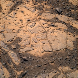
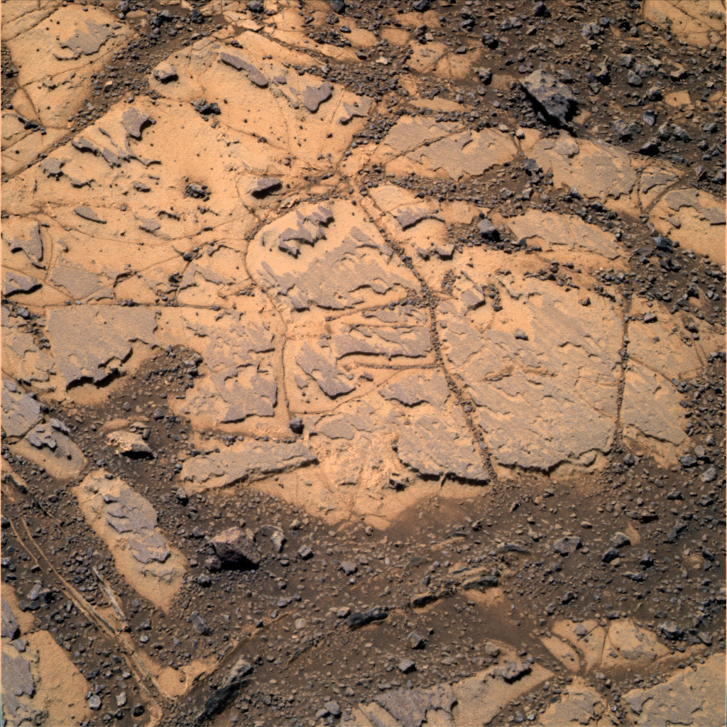
Part of Falconbridge Pancam, Sol 3119:
Click to view attachment
Is the white stuff there just sand?
Full Version: Matijevic Hill first survey
QUOTE (ronald @ Nov 3 2012, 12:47 PM) 
Is the white stuff there just sand?
Yep. Great work!!!

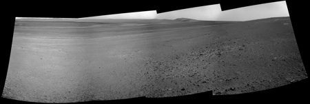
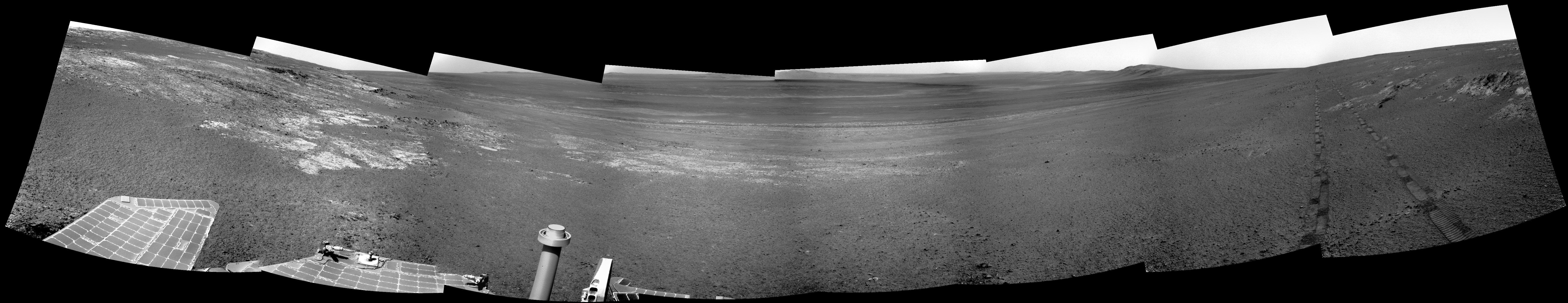
Sol 3119 Navcam pan :
And Sol 3121 :


And Sol 3121 :
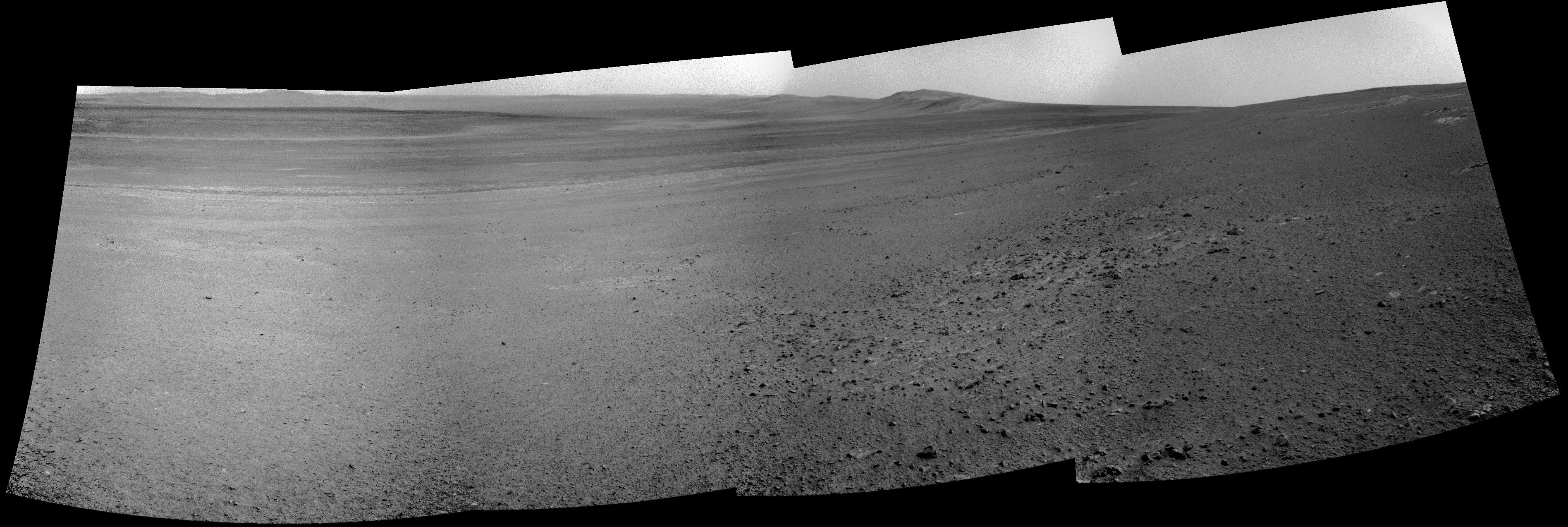
Here is Ant103's 3121 half pan in circular format - another drive to the south. We are approaching the big ancient crater.
Phil
Click to view attachment
Phil
Click to view attachment
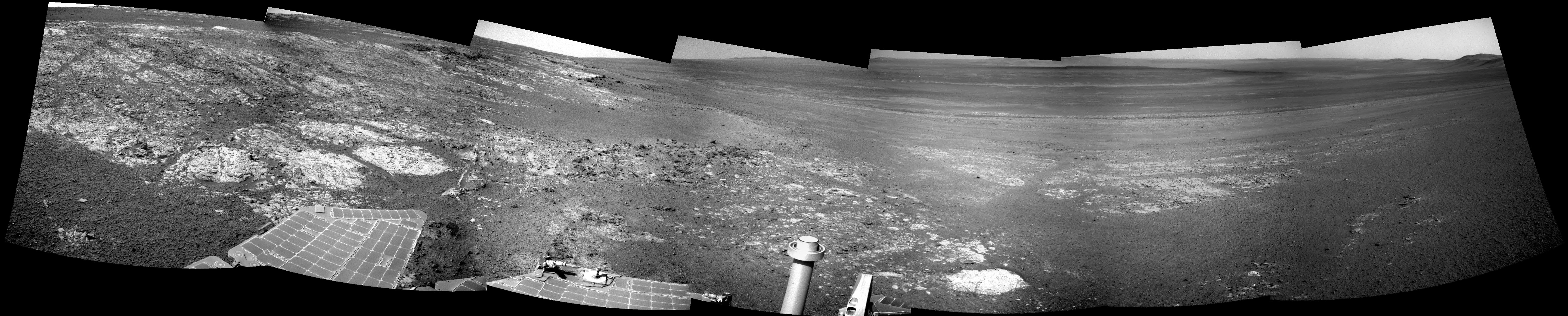
This is a vertically stretched view of the crater ahead - viewed from the north so not in route map geometry.
Phil
Click to view attachment
Phil
Click to view attachment
[quote name='ronald' date='Nov 3 2012, 01:15 PM' post='194089']
Color variation of Coniston - Pancam, Sol 3119:
I am fairly new to these forums.
Many of you are producing beautiful approximations of Mars "true" color from the MER filter 2, 5, 7 filters. Could you describe the process you are using or point me back to discussion of this topic? I have searched without success.
ADMIN: Give these pages a try:
http://www.unmannedspaceflight.com/index.php?showtopic=761
http://www.unmannedspaceflight.com/index.php?showtopic=529
Use the Forum search tool and use a term like "Filters"
Beautiful undulations on that filled-in crater ahead:
Click to view attachment
And an anaglyph teased out of images from Sol 3054 and from around Sol 3114, a baseline shift of around 80 meters. It's a little headache-inducing at the nearest mountain, I'm guessing due to the difference in elevation between the two images.
Click to view attachment
Click to view attachment
And an anaglyph teased out of images from Sol 3054 and from around Sol 3114, a baseline shift of around 80 meters. It's a little headache-inducing at the nearest mountain, I'm guessing due to the difference in elevation between the two images.
Click to view attachment
QUOTE (walfy @ Nov 5 2012, 03:44 AM)
It's a little headache-inducing at the nearest mountain,
I believe that your nearest mountain happens to be a future destination of Opportunity. Perhaps the headaches are caused by staring at a 3d view with too much intensity. I actually pasted your anaglyph into IrfanView and expanded it. The details got fuzzy, but the shape of the mountain became clearer to me. Thank-you very much.
While still waiting for all Falconbridge files I did a quick try on Gertrude - Sol 3117:
Click to view attachment Click to view attachment
Click to view attachment Click to view attachment
Nice colors Ronald
Sol 3121 Navcam pan updated (see my previous post).
Sol 3121 Navcam pan updated (see my previous post).
Thank you Ant - Sao Pantaleao on Sol 3121:
Click to view attachment
Big version here. Sorry no false color this time but a nice corresponding anaglyph of the far left rock formation.
- Sao Pantaleao on Sol 3121:Click to view attachment
Big version here. Sorry no false color this time but a nice corresponding anaglyph of the far left rock formation.
QUOTE (ronald @ Nov 5 2012, 09:52 PM)
While still waiting for all Falconbridge files I did a quick try on Gertrude - Sol 3117:
Click to view attachment Click to view attachment
Click to view attachment Click to view attachment
Any idea what process can cause the ring-like crack in the lower left half the rock?
QUOTE (CosmicRocker @ Oct 29 2012, 06:38 AM)
This is quite a fascinating area. Has anyone deciphered the stratigraphy yet? 
Im really starting to doubt that any coherent stratigraphy can be teased out of Cape York. Using Meloshs impact crater morphometric parameters as a guideline the Endeavour rim would have been some 800 metres above the surrounding terrain. This has eroded down to a nub. Potentially all ejecta deposited in the Endeavour impact may have been removed and the Noachian core of Cape York could be upturned or overturned, pre impact terrain. This would have mainly been Miyamoto ejecta in the first place and interpreting this area with Opportunity's limited assets may well be impossible.
Is it possible that Endeavor crater eventually filled up with upwelled water after the impact that created it and over time the crater wall in the area of Cape York eroaded away with the water spilling out into the plains? Would it not be prudent to investigate the bottom of the crater in this area to look at possible sediments that may have filtered out at this location?
I think it's more likely that we will be able to understand the stratigraphy of post-impact modification. The old rim of Endeavour was subjected to erosion and deposition, maybe multiple times, and remnants of those events are what we might expect to see here. Details of the original rim stratigraphy, especially things like overturned strata at the original rim (probably lost to slumping and erosion long ago) are not likely to be preserved.
Phil
Phil
You may well be right, but I think the possibility that the Kirkwood layer is pretty much in situ since the impact cannot be excluded. The obvious chaos only appears upslope from Kirkwood. I'm sure the hunt is on for a possible continuation of the Kirkwood layer at Cape Tribulation.
QUOTE (Mars Attack @ Nov 8 2012, 02:00 PM)
Is it possible that Endeavor crater eventually filled up with upwelled water after the impact that created it ....? Would it not be prudent to investigate the bottom of the crater in this area to look at possible sediments that may have filtered out at this location?
Given the evidence of a groundwater table rising to the surface at the elevation of Erebus then there is a reasonable argument for deeper water within Endeavour. But north of Cape York the crater rim was overrun by sulphate sediments which form that intriguing delta like infill, so the crater bottom would probably be more yet sulphate sandstone with hematite concretion lag, covering all the interesting stuff beneath. I guess one question is whether the crater was once completely filled and then excavated to the current topography, or whether the infill reflects the configuration reached before the area became pretty well static. If the latter then the possibility of Endeavour having been a water filled stratigraphic trap would seem to be increased.
Falconbridge - Pancam Sol 3119:
Click to view attachment Click to view attachment
Full version here and here. Partial anaglyph in this post.
Click to view attachment Click to view attachment
Full version here and here. Partial anaglyph in this post.
This one - just labeled outcrop ejecta - will be a nice one too (3x1 when all data is down):
Click to view attachment Click to view attachment
Click to view attachment Click to view attachment
Now this is really the last one for today 
Makada Lake, Pancam Sol 3124
Click to view attachment
I also noticed that the two colored ones above came out a bit too desaturated - at least looking at them from home now. At work it looked ok. I'll pay more attention to this in the future.
Makada Lake, Pancam Sol 3124
Click to view attachment
I also noticed that the two colored ones above came out a bit too desaturated - at least looking at them from home now. At work it looked ok. I'll pay more attention to this in the future.
I welcome participants. Allow also to me to take part in discussion.
Surprising repeatability of forms. Rectangular structures under wheels of Opportunity http://qt.exploratorium.edu/mars/opportuni...EGP0142L0M1.JPG
and from the satellite:
Surprising repeatability of forms. Rectangular structures under wheels of Opportunity http://qt.exploratorium.edu/mars/opportuni...EGP0142L0M1.JPG
and from the satellite:
The small-scale features are what the team calls the "boxwork" features, around the 3101 and 3103 sites.
We were close to the large-scale rectangular features/lineations/"tardis features" on sol 2742. We tried to spot them in the imagery, but saw nothing conclusive - check around this post.
We were close to the large-scale rectangular features/lineations/"tardis features" on sol 2742. We tried to spot them in the imagery, but saw nothing conclusive - check around this post.
Thanks. Yes, really from above it looked more interesting.
I, as the archeologist, can't quietly look at them
I, as the archeologist, can't quietly look at them
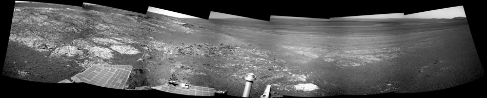
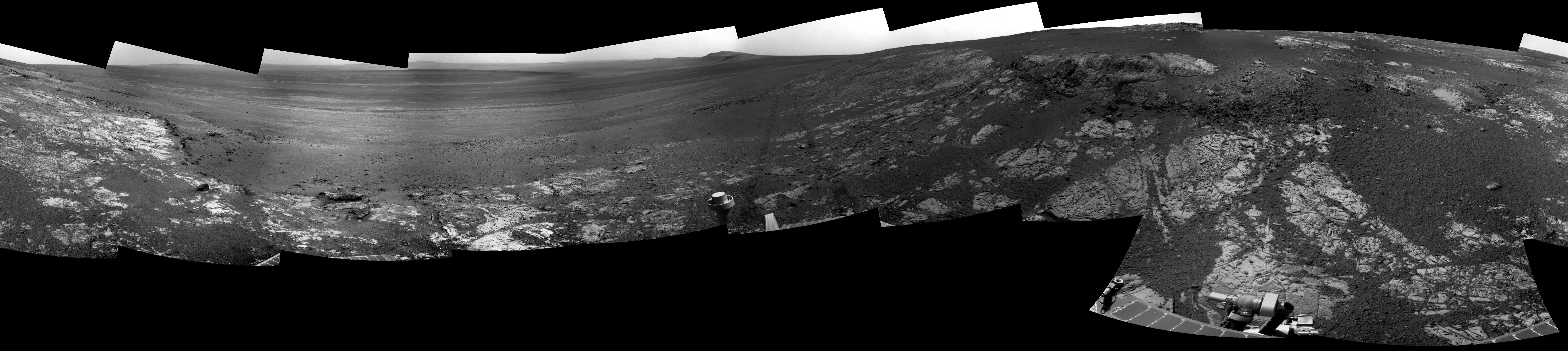
Sol 3124 Navcam pan :

A look back on Sol 3124:
Click to view attachment
Click to view attachment
This is the current state of my map of Matijevic hill, trying to fit in all the feature names (I'll add diacritical marks later) with the route. I see I left out Gertrude - if you know any other names I can add please let me know. Names around Whitewater Lake such as Kirkwood will be on a separate close-up map.
Phil
Click to view attachment
Phil
Click to view attachment
Looking good, Phil. Just one question: is "Box Work" the name of a particular feature, or was it just used to describe a type of feature? The latest PS update mentions
QUOTE
on Sol 3101... the robot field geologist took pictures of boxwork and possible veins in light-toned bedrock
and thenQUOTE
on 3103... the MER scientists noted boxwork again.
That makes it sound like a type of feature.
I think the answer is "both", Fred, because one of the features imaged during sol 3103 was labelled exactly "Box Work".
Good point though - is it really a name or just a description? I have been finding lots of features in the Opportunity feature names database in the Analysts Notebook at PDS Geosciences with names like 'cobble 2' or 'layered ripple', which I don't usually plot as a feature name on the route maps I'm making for future use. Normally I only use things I think are 'real' placenames. I haven't decided about this one yet.
Phil
Phil
Very nice work Phil! There are some more named features ...
rather small Cartier (1+2) on Sol 3117 for instance:
Click to view attachment Click to view attachment
The left one is a somewhat different approach to false color (false color plus pseudo color)
... Levack and Lively on Sol 3119 (near Falconbridge), Onwatin on Sol 3124, Nipissing 1+2 Sol 3126, Clara Belle and Agnew Lake both Sol 3128 and maybe much more before Sol 3117 
Box Work is indeed the name of that specific Sol 3103 feature - more common descriptions like "rear outcrop", "ejecta" or "driving direction" are allways lower case, specific names upper case ...
rather small Cartier (1+2) on Sol 3117 for instance:
Click to view attachment Click to view attachment
The left one is a somewhat different approach to false color (false color plus pseudo color)
... Levack and Lively on Sol 3119 (near Falconbridge), Onwatin on Sol 3124, Nipissing 1+2 Sol 3126, Clara Belle and Agnew Lake both Sol 3128 and maybe much more before Sol 3117
Box Work is indeed the name of that specific Sol 3103 feature - more common descriptions like "rear outcrop", "ejecta" or "driving direction" are allways lower case, specific names upper case ...
Hmm - either I missed it or it wasn't yet posted here - Box Work with some lag from Sol 3103:
Click to view attachment Click to view attachment
Click to view attachment Click to view attachment
I had to look it up but I now understand 'boxwork' to mean a network of intersecting planes governed by the process of crystal formation. I can't convince myself that these 'boxes' formed that way. The edges are not perfectly straight, in fact there are some quite curvy ones. To me they look more like patterns formed by fracture rather than crystallisation.
Fractures filled with something and then eroded... I don't think they are intending the name literally to refer to crystallization, just referring to the general morphology.
Phil
Phil
Sol 3128 Navcam -incomplete yet- pan :
I assume this could be Nickeldale - Sol 3132 - maybe the next RAT target?
Click to view attachment
I'll correct the naming (if there is any) when I'm wrong
Click to view attachment
I'll correct the naming (if there is any) when I'm wrong
Here's a navcam mosaic taken on that same sol but from a different position. She's getting closer to Whitewater Lake.
Click to view attachment
Click to view attachment
I used the outer left navcam pics for the anaglyph - so its the same position.
I did a quick polar one:
Click to view attachment
Interesting twitter message from Mike Seibert regarding sol 3132 movement.
This one is sol 3133:
Click to view attachment
Near 2 o'clock you can see Kirkwood and the tracks leading there
I did a quick polar one:
Click to view attachment
Interesting twitter message from Mike Seibert regarding sol 3132 movement.
This one is sol 3133:
Click to view attachment
Near 2 o'clock you can see Kirkwood and the tracks leading there
Big jump in tau on 3134 according to the solar pancam images. (No 3134 images showing the horizon down yet.) This is the right time of the year for it.
This image is a bit special, I think, what with a nice complete skyline on top of spectacular geology:
http://qt.exploratorium.edu/mars/opportuni...23P1737R0M2.JPG
http://qt.exploratorium.edu/mars/opportuni...23P1737R0M2.JPG
Yes, this is really a nice one.
After having a hard time with the navcam pan-anaglyph (which turns out only semi-middle or mittelprächtig in german) I decided to make a cross-eyed version with some sky
Click to view attachment Click to view attachment
After having a hard time with the navcam pan-anaglyph (which turns out only semi-middle or mittelprächtig in german) I decided to make a cross-eyed version with some sky
Click to view attachment Click to view attachment
Fascinating indeed. In the bottom left corner of Stu's anaglyph, it looks like there's a collapsed tube, which meets another in a T-junction. Wind-eroded volcanic remnants?
A bunch of new Navcam pan today.
Sol 3131 :

Sol 3131 :
And Sol 3135, with very interesting outcrops.
A color close-up :
Sol 3131 :
Sol 3131 :
And Sol 3135, with very interesting outcrops.
A color close-up :
It's Sandcherry Sol 3135:
Click to view attachment Click to view attachment
The cross-eye is not for the faint-hearted though ...
Nice colors Ant
Click to view attachment Click to view attachment
The cross-eye is not for the faint-hearted though ...
Nice colors Ant
What a great place this is! Hopefully we have seen enough of the area for a good geological map of the outcrops to be compiled, and some serious analysis of the different units can begin.
Phil
Phil
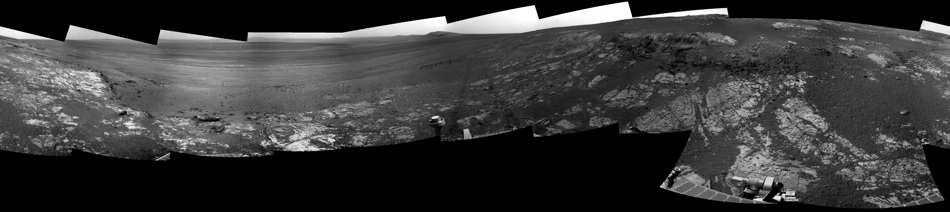
Ant103's sol 3135 pan in circular form - with a good view of the earlier tracks leading up to Kirkwood. The loop is nearly closed now.
Phil
Click to view attachment
Phil
Click to view attachment
This is a "lo-fi" version of our main content. To view the full version with more information, formatting and images, please click here.