Burmese
Oct 13 2012, 08:17 PM
QUOTE (nprev @ Oct 13 2012, 11:08 AM)

Could be almost anything; remember all the bizarre mineral layers Spirit exposed over at Home Plate. Hopefully they'll find it worth a ChemCam zap.
...Wonders if any of the sleep-deprived scientists at JPL trying to straddle developments on both rovers have made similar comments at an Oppy SOWG meeting...
nprev
Oct 13 2012, 08:22 PM
Doubt it; they are considerably smarter than drunken, disreputable robots...

ronald
Oct 13 2012, 09:14 PM
QUOTE (Floyd @ Oct 13 2012, 06:58 PM)
Hay everyone, there are fantastic pancams down today.
Huh nice - something to play with
 Click to view attachment Click to view attachment Click to view attachment Click to view attachment
False color images with reduced green and blue channel - I like it marslike

morganism
Oct 13 2012, 10:47 PM
glacial feature - kames. would sure explain a lot of the features we see around here, and at Mt. Sharp.
We always think of them as moving.
http://www.landforms.eu/cairngorms/kame.htmhttp://www.physicalgeography.net/fundamentals/10af.html
Bill Harris
Oct 14 2012, 02:01 AM
Times are going to get interesting. With site names like Possible_Contact, Broken_Hammer, Upturned_Bed, Aft_Outcrop, site168_recon1, site168_recon2 and Chelmsford2and3 they should be very interesting.
--Bill
serpens
Oct 14 2012, 03:31 AM
QUOTE (morganism @ Oct 13 2012, 10:47 PM)
glacial feature - kames.
Don't see it.
walfy
Oct 14 2012, 04:22 AM
Stu
Oct 14 2012, 09:49 AM
Couple of new colour views... can't get on the tracking website to ID them, so apologies for the lack of labels...
Click to view attachmentClick to view attachmentMore at:
http://roadtoendeavour.wordpress.com/2012/...4/catching-up-2
ronald
Oct 14 2012, 11:19 AM
Sol 3098 pancam false color:
Click to view attachment
Stu
Oct 14 2012, 11:49 AM
Very nice... was just working on that one myself...
Click to view attachment
Bill Harris
Oct 15 2012, 02:18 AM
CosmicRocker
Oct 15 2012, 05:12 AM
QUOTE (Bill Harris @ Oct 13 2012, 09:01 PM)
... With site names like Possible_Contact, Broken_Hammer, Upturned_Bed, Aft_Outcrop, site168_recon1, site168_recon2 and Chelmsford2and3 they should be very interesting. ...
A couple of those are very interesting names. I don't remember ever getting such nice clues to targets in the past.
QUOTE (Stu @ Oct 14 2012, 04:49 AM)
Couple of new colour views... can't get on the tracking website to ID them, so apologies for the lack of labels...
The first one apparently goes by the cryptic moniker, "pancam_site168_recon1." Your second image was called, "Kirkwood_back."

walfy
Oct 15 2012, 05:30 AM
Interesting angled outcrop at the base of this image, almost rectangular.
Click to view attachment
CosmicRocker
Oct 15 2012, 05:54 AM
QUOTE (morganism @ Oct 13 2012, 05:47 PM)
glacial feature - kames. would sure explain a lot of the features we see around here, and at Mt. Sharp. ...
Of all the various kinds of glacial deposits: the various moraine types, eskers, drumlins, kames, erratics, etc; kame deposits have become my favorite of them all.
I have long suspected that glacial geology may have had a significant influence on Mars. Can you point out where you suspect you see kame deposits on Cape York, because I don't see it.
Mt. Sharp may possibly be a whole different story. I'm trying to keep an open mind with regard to its genesis.
ronald
Oct 15 2012, 10:27 AM
Sol 3101 hazcam anaglyph - stretched it is:
Click to view attachment
Ant103
Oct 15 2012, 01:11 PM
Sol 3101 Navcam pan
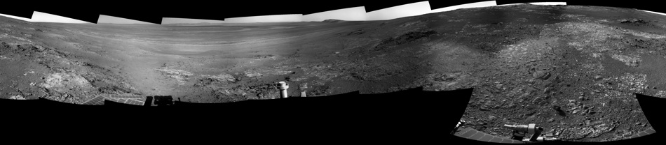
Amuzing how Hugin has made the blendings on the black missing part of one frame.
Tesheiner
Oct 15 2012, 02:21 PM
Beautiful mosaic (as usual) Damien. I did the same one using Autostitch but refrained from posting because I knew you would make and post a much better one.
Here's a polar view of this site.
Click to view attachment
climber
Oct 15 2012, 06:51 PM
May be Damien is doing a route map but refrains from.... Jajaja!
By the way you may want to rename the thread "Oppy snail route map" these days.
Stu
Oct 15 2012, 07:07 PM
QUOTE (climber @ Oct 15 2012, 07:51 PM)
By the way you may want to rename the thread "Oppy snail route map" these days.
Oppy's doing just fine, taking her time. She's an 8 year old kid, locked on her own in a geological sweetie shop. Why would she rush?
climber
Oct 15 2012, 08:29 PM
I was refering at the SHAPE of the route (have a look)! It does look as a snail.
I fully agree with you, no rush, specialy now that we've found such a nice spot. Sorry for the confusion.
Stu
Oct 15 2012, 08:30 PM
Ahhh.... see what you mean...
marsophile
Oct 16 2012, 03:16 AM
QUOTE (walfy @ Oct 14 2012, 09:30 PM)
..., almost rectangular.
How about this for right-angles? (x-eye stereo)
Click to view attachment
Joffan
Oct 16 2012, 04:33 AM
Wow, we've found the remains of the ancient Inca mouse city. They even had cavity walls.

ElkGroveDan
Oct 16 2012, 02:49 PM
Heavily salted mud will dry like that in seasonal lake beds - it's caused by the salt crystallization within the the silt and mud. (Not saying that's what is going on here.)
marsophile
Oct 16 2012, 08:58 PM
http://qt.exploratorium.edu/mars/opportuni...EGP0142L0M1.JPGThe whitish rock here may have a dense covering of vein material.
morganism
Oct 16 2012, 11:47 PM
Kames as glacial geo builders are an excellent way to build up structures in a non-moving glacier. They are known for trapping liquids below deck, and for damming up side stream sediments.
We only think of glacial features created by moving ice, but if the entire body is covered, as in an ice ball model, it would be one of the only geo active models to work with. That, and the mud volcano theories of Gold. I am thinking almost all the hydro features we are seeing are actually from liquid methanol from old methane hydrates deposits. Not sure what kind of minerological deposits this would create, as the undersea ones here do hydrocarbon traps, and noble gases, and water purification of all things.
If methanol was the carrier, instead of water, i wonder what depositions from solution it would deposit, and if it has a preferential surficial cracking pattern like the three section mud dessication map. testable? load up some methonol and let it dry in the freezer on some different substrates? see if it dries at right angles?
Am thinking of all the erratics we find on all the surfaces, and the wild cross bedding and tall layered hills and hoodoos we are seeing at Mt. Sharp.
There are very few thing that can build up a layered peak in the center of a crater, but a mud volcano that punches up, then has the flows infall in a kame pit might build up just the structures we are seeing.
With such a low atmospheric density, nearly all meteorites should be leaving some cratering, but we dont see any small , or even many mid sized craters near these impactors.
this post is prob gonna be pulled too.....
Tesheiner
Oct 17 2012, 03:18 PM
There's nothing special with this image itself. Just one of a set of navcam shots taken as part of the "end-of-drive" sequences.
Click to view attachmentBut I just would like to remark that it was available for everyone on the net less than
three hours after it was taken on mars.
Image info for: 1N403749549EFFBWGXP1657L0M1
Spacecraft: OPPORTUNITY
Camera: NAVCAM, left
Spacecraft clock: 403749549 (seconds since January 1, 2000, 11:58:55.816 UTC)
Product type: EDR full frame
Site number: BW
Drive number: GX
Command sequence number: P1657 (PMA or remote sensing instrument) NAVCAM
Producer: MIPL/JPL
Acquisition time (Earth): Wed Oct 17 14:27:02 2012
Time zone: Hora estßndar romance
Acquisition time (Mars): Sol 3104 13:35:33
Current local time (Earth): Wed Oct 17 17:19:14 2012
Current local time (Mars): Sol 3104 16:19:39
Elapsed time since acquisition: 0 days, 02:48:36On another topic, tosol (3104) and yestersol were driving days. Map update soon.
Ant103
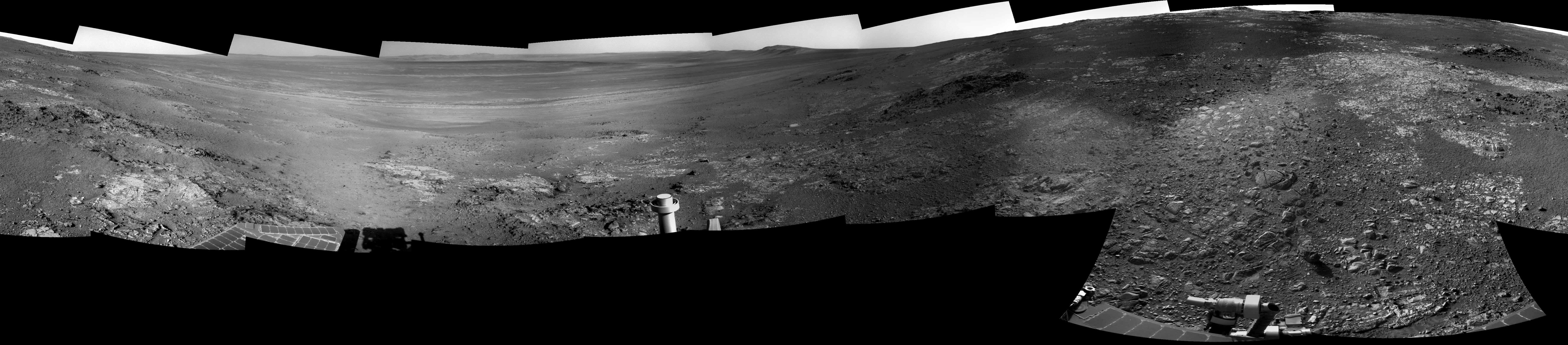
Oct 17 2012, 10:19 PM
Sols 3
103 & 3104 Navcam pans

BrianL
Oct 17 2012, 11:28 PM
Another drive or two this way and we will need a new thread.

Phil Stooke
Oct 17 2012, 11:58 PM
The last three pans - thanks Ant103! - in circular form. If you save them the file names identify the sol.
Phil
3098:
Click to view attachment3103:
Click to view attachment3104:
Click to view attachment
walfy
Oct 18 2012, 09:03 PM
Very nice new pics down. Fantastic formation from Sol 3103:
Click to view attachmentFrom 3101:
Click to view attachment
walfy
Oct 18 2012, 09:20 PM
Just one more for now, too nice not to share!
Click to view attachment
ronald
Oct 18 2012, 10:07 PM
Really nice stuff!
I did a try on a partial sol 3105 sort of anaglyph:
Click to view attachmentAll angles might be really off though

Stu
Oct 18 2012, 10:12 PM
mhoward
Oct 18 2012, 10:21 PM
Pretty cool stuff. I think may favorite is just to the west on Sol 3105, top and about 1/3 from the left in this anaglyph, top in the stereo pair.
Explorer1
Oct 19 2012, 01:08 AM
I recently got red/blue glasses, so I really have to agree: this place is marvelous...
PDP8E
Oct 19 2012, 11:50 PM
here is an interesting image ( SOL 3101 ) of a L257 set
Click to view attachment
Ondaweb
Oct 20 2012, 02:09 AM
It certainly is. That may help the scientist but it complicates the picture for me.
mhoward
Oct 20 2012, 06:31 PM
Looks very different from the side on sol 3107, but I like it. This view is facing west. Edit: the view looks very different because the drive was longer than I thought and we're in a completely different place than I originally thought. "Never mind"
Since Opportunity is nearly at the top, I wonder how long it will be before we see her tracks from 350 sols ago. Possibly not long.


ronald
Oct 20 2012, 08:02 PM
Stu
Oct 21 2012, 09:05 AM
Looks like Oppy has found her very own mini Mt Sharp...
Click to view attachment
Stu
Oct 21 2012, 05:10 PM
Oh my... look at that...
Click to view attachment
nprev
Oct 21 2012, 05:35 PM
Good grief.
That is a
ridiculously complex little formation, isn't it?
VERY nice anaglyph, Stu!
mhoward
Oct 21 2012, 05:47 PM
The PCDB label for the whole outcrop (not just the rather striking broken part on the end) is "Stobie". The 5x1 Pancam mosaic was taken on sol 3107 before the drive.
ronald
Oct 21 2012, 06:20 PM
Sol 3107 pancam pan - "Stobie":
Click to view attachmentI did only found images for a 3x1 so far ...
MoreInput
Oct 21 2012, 06:45 PM
QUOTE (Stu @ Oct 21 2012, 11:05 AM)
Looks like Oppy has found her very own mini Mt Sharp...
My thoughts exactly when I looked at MHowards panorama before I saw your post ...
mhoward
Oct 21 2012, 08:56 PM
QUOTE (ronald @ Oct 21 2012, 11:20 AM)
Sol 3107 pancam pan - "Stobie":
I did only found images for a 3x1 so far ...
It's kind of an unusual 5x1, composed of 3 'horizontal' subframes (the ones you've got), a full-frame (or close to it) to the right of that and a 'vertical' subframe on the far right. And then there's a 3x1 of images closer to the rover, also labelled "Stobie". I'll post a context view if some more color comes down.
CosmicRocker
Oct 22 2012, 04:43 AM
These are some of the most astounding outcrops I have ever seen. I wonder if Opportunity will ever be able to leave Cape York.
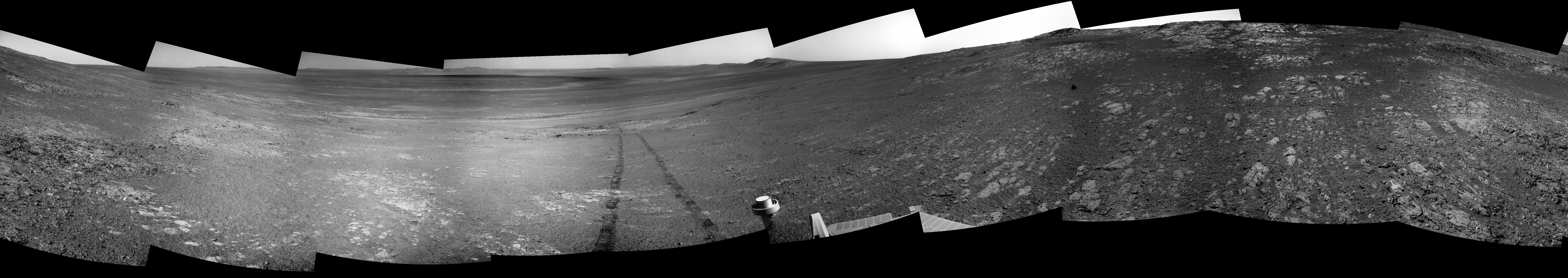
Tesheiner
Oct 22 2012, 08:48 AM
Here's my crude attempt on the navcam mosaic taken at the current site (sol 3107).
Click to view attachment
Tesheiner
Oct 22 2012, 09:30 AM
QUOTE (mhoward @ Oct 20 2012, 08:31 PM)
Since Opportunity is nearly at the top, I wonder how long it will be before we see her tracks from 350 sols ago. Possibly not long.
Quite close to the site she was during sols 2751-2754.
Click to view attachmentLet's see if I can find a mosaic from that timeframe. Found
this post of yours.
This is a "lo-fi" version of our main content. To view the full version with more information, formatting and images, please
click here.