jamescanvin
Oct 22 2012, 10:53 AM
QUOTE (Tesheiner @ Oct 22 2012, 10:30 AM)

Found
this post of yours.
Almost exactly 1 (Earth) year ago.
mhoward
Oct 22 2012, 02:18 PM
Wow, I remember that sol 2751 mosaic. I was thinking something like, "Those outcrops look good, too bad she can't get over there." But I had no idea.
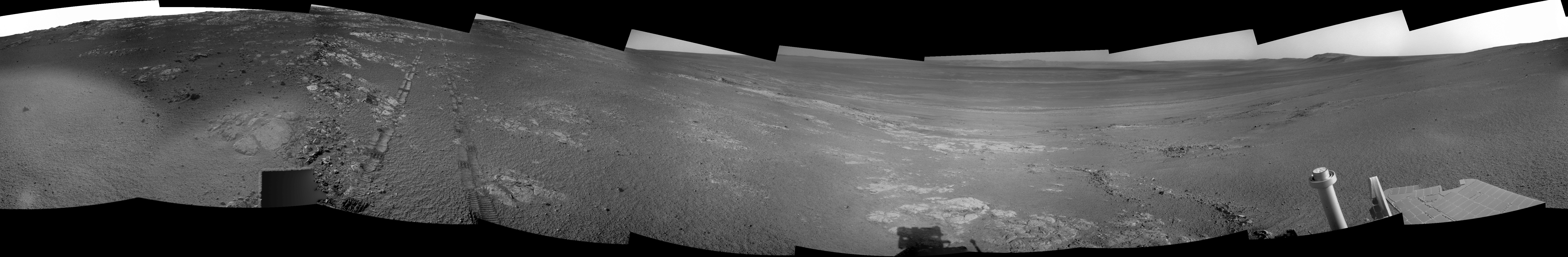
Most of the frames of Stobie are down now; here's a context view facing NE on sol 3105-3107.

And another view looking N from the same position, showing a single frame of "Totten", with Stobie on the far left.

mhoward
Oct 22 2012, 03:04 PM
Just out of curiosity I went back to the sol 2751-2754 timeframe to see if there are any labelled Pancam images. Sure enough there are a couple; for example this is "Havelock", sol 2753, from the same position as that sol 2751 Navcam mosaic. I'm not sure where Havelock is relative to where we are on sol 3107; maybe someone can figure it out. Also, on sol 2751, there is "Moodies".
A little flashback: sol 2749 was when we saw two sets of Pancam drive direction images: a 3x1 to the north, and one to the east labelled "pancam drive direction 2x1 inboard" (emphasis mine). Were they thinking about it? Or scouting way ahead?
mhoward
Oct 22 2012, 03:47 PM
Last post: Based on Tesheiner's map, I'm going to guess that the outcrop Opportunity is approaching after the drive on sol 3107 is Havelock! Seen here, from the other side, on sol 2753. And the dark area on the left in that image would be the jagged end of Stobie! I'm not positive, but it seems to fit. So cool.
fredk
Oct 22 2012, 05:25 PM
I think you've nailed it. Here's a comparison of what appears to be Stobie imaged on sols 2751 and 3107:
Click to view attachmentThe viewing directions are very different between those two views, but combined with the map positions and navcam mosaics I think these are the right identifications.
Edit: do we have a name for the front side (downslope side) of Havelock that we're now sitting in front of?
Tesheiner
Oct 22 2012, 06:13 PM
Perfect match!
QUOTE (fredk @ Oct 22 2012, 07:25 PM)
Edit: do we have a name for the front side (downslope side) of Havelock that we're now sitting in front of?
I checked the pancam sequences shot since sol 3104 and none of them match that outcrop.
MERovingian
Oct 22 2012, 06:39 PM
Do you think that there would be some good science in getting Oppy back to its sol 2751 wheel tracks, just to check out how much of it was so far erased by the Martian weather in 360 Sols?
nprev
Oct 22 2012, 08:23 PM
In a word...no. MRO can do a far better job monitoring long-term changes in the tracks, the vast majority of which will undoubtedly be fine bright dust deposition.
mhoward
Oct 22 2012, 08:41 PM
Well, perhaps some value, but it's been done - way back when leaving Endurance, IIRC.
Phil Stooke
Oct 22 2012, 08:44 PM
And repeated at Victoria.
Phil
ronald
Oct 22 2012, 08:54 PM
New try on Stobie pancam pan:
Click to view attachment
PDP8E
Oct 23 2012, 01:11 AM
Here is an image from Sol 3104 (site/drive:BWEG). Its in the Stobie region.
Click to view attachment
ronald
Oct 23 2012, 08:55 AM
jvandriel
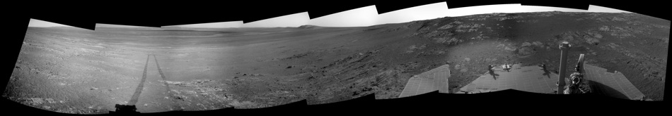
Oct 23 2012, 01:48 PM
Sol 3107 Panoramic Navcam L0 view.
Jan van Driel
Click to view attachment
MERovingian
Oct 23 2012, 06:44 PM
QUOTE (Phil Stooke @ Oct 22 2012, 10:44 PM)
And repeated at Victoria.
Phil
I keep forgeting how old and experienced is our girl.
"Been there, done that!!"
she could have answered!
Thanks for clearing that out for me, guys! This is one question that won't pop out of my mouth next time Oppy crosses her own tracks again on, say, sol 5000 or perhaps 6000!!

RoverDriver
Oct 23 2012, 07:40 PM
QUOTE (MERovingian @ Oct 22 2012, 11:39 AM)
Do you think that there would be some good science in getting Oppy back to its sol 2751 wheel tracks, just to check out how much of it was so far erased by the Martian weather in 360 Sols?
As Phil and others have mentioned, this has been done before. Specifically in the Sol 1600s Oppy analyzed her tracks from Sols 950s (arrival at Victoria, pre dust storm), 1290s (post dust storm) and her most recent tracks at the time (after soending one Earth year in Duck Bay). I think we took NAV/PAN and HAZ, maybe MIs as well. I don't recall the specific Sol number but it is definitely after 1634 and before 1659. I think this is one of them:
http://marsrovers.jpl.nasa.gov/gallery/all...YP1981L0M2.HTML You can clearly see the three different type of tracks. That is a span of about 700 Sols!
Paolo
jamescanvin
Oct 24 2012, 08:18 AM
And don't forget about Spirit! She crossed tracks that were over 1000 sols old on a number of occasions.
Ant103
Oct 24 2012, 10:05 AM
Sol 2110 *whooooops* 3110 Navcam pan :

Tesheiner
Oct 24 2012, 11:17 AM
QUOTE (jamescanvin @ Oct 24 2012, 10:18 AM)
And don't forget about Spirit! She crossed tracks that were over 1000 sols old on a number of occasions.
QUOTE (Ant103 @ Oct 24 2012, 12:05 PM)
Sol 2110 Navcam pan :
Speaking about 1000 sols old ...
Ant103
Oct 24 2012, 11:37 AM
Oops, sorry

Unintentional error

Tesheiner
Oct 24 2012, 12:31 PM
Now seriously, I was wondering what could be the reason for the, mmm, illumination effect observed on two of the navcam shots making the sol 3110 mosaic. I don't think that's a real difference on the soil itself.
Click to view attachment Click to view attachment
Ant103
Oct 24 2012, 12:57 PM
This is just a solar flare on the lenses.
fredk
Oct 24 2012, 03:10 PM
Yeah, we tend to get that glare when we look closely towards the sun with navcam, and being on this east-facing slope we tend to do that in the afternoons.
BTW, in Ant's latest navcam mosaic I like how you can see so much of our recent tracks around the "loop".
mhoward
Oct 24 2012, 09:54 PM
"Garson" (sol 3110)

And, yes, I'll say it... that is one hoopy Frood (left)

Yes, it's name is Frood. The outcrop to the SSE on sol 3110 is "Podolsky". It appears that the ragged end of Stobie may be named "Strathcona".
serpens
Oct 25 2012, 05:10 AM
While I guess all these are named after the Sudbury mines, the Hitchhiker's Guide definition of Frood (A really amazingly together guy) certainly does apply to Opportunity, if not the rock.
ronald
Oct 25 2012, 03:48 PM
Ant103
Oct 26 2012, 10:52 AM
Great Ronald

Sol 3110 Navcam pan is updated (see my previous post).
Floyd
Oct 26 2012, 11:35 AM
I've lost my orientation of Carson relative to the crater. The layering in Carson seems almost edge on dipping slightly to the left in this view. What compass direction was the camera facing?
Tesheiner
Oct 26 2012, 12:26 PM
Floyd
Oct 26 2012, 02:36 PM
Thanks Tesheiner--That helps a lot.
ronald
Oct 27 2012, 08:23 AM
Ant103
Oct 27 2012, 03:57 PM
Sol 3112 Navcam pan :
Very good color mosaics Ronald, this is a very good job
!
Tesheiner
Oct 27 2012, 04:55 PM
Here's my take on a polar view of that site.
Click to view attachmentQUOTE (serpens @ Oct 25 2012, 07:10 AM)
While I guess all these are named after the Sudbury mines, the Hitchhiker's Guide definition of Frood (A really amazingly together guy) certainly does apply to Opportunity, if not the rock.
Ok, so that means "Podolski" was definitely not named after
this person.
ronald
Oct 27 2012, 07:54 PM
Thanks Ant - glad you like it
So this one is from the sol 3110 position - its not
Ösil nor is it
Schweinsteiger - its somewhat fuzzy
MacLennan:
Click to view attachment Click to view attachmentMcConnell from the same sol looks even better but unfortunately one L7 is still missing ...
Phil Stooke
Oct 29 2012, 12:01 AM
I'm trying to locate named features now we are getting so many. Please add others if you have them.
Phil
Click to view attachment
mhoward
Oct 29 2012, 05:16 AM
Phil: Here are some more, based on Tesheiner's map and my own estimates. I've placed the labels slightly under where I think the features are located, rather than take the extra time to draw arrows.
CosmicRocker
Oct 29 2012, 05:38 AM
This is quite a fascinating area. Has anyone deciphered the stratigraphy yet?

ngunn
Oct 29 2012, 07:24 PM
I'm not surprised there are no serious takers on that question! 'Jumbled' is the word that comes to mind for this upper part.
serpens
Oct 29 2012, 08:39 PM
ngunn you are a master of understatement. More like chaotic.
dvandorn
Oct 30 2012, 01:27 AM
Steve Squyres' term "dog's breakfast" seems appropriate, here.
-the other Doug
fredk
Oct 30 2012, 02:34 PM
QUOTE (Phil Stooke @ Oct 29 2012, 01:01 AM)
I'm trying to locate named features now we are getting so many.
A hint of a naming system for sites in
this post:QUOTE
Opportunity's Sol 3114 drive to Station 6 on Matijevic Hill
PaulM
Oct 31 2012, 06:54 PM
I do not know if this is the correct thread in which I should ask this question?
My question is whether there are any links in which list the safety checks that are made by MER rovers as they drive along which could result in the premature termination of an autonimous drive? I know for example that there is a parameter in the MER software which specifies the percentage of slip that is acceptable during a drive. Maximum tilt allowed during a drive can also be specified. Can anyone remember the other parameters that can be tuned to ensure that a MER rover remains safe during a drive?
My reason for asking this question is that I know someone who is involved in the design of autonimous rover software who would be interested in an as detailed as possible answer to my question.

Tesheiner
Oct 31 2012, 10:03 PM
Here is a navcam mosaic taken during sol 3117 and the corresponding polar view,
Click to view attachmentClick to view attachment
ronald
Oct 31 2012, 10:11 PM
... and the corresponding anaglyph
Click to view attachmentthough I'm not yet satisfied with my method for vignette removal (simple highpass) ...
walfy
Nov 2 2012, 04:00 AM
Ahh, yes, next to a crater again.
Click to view attachment
Tesheiner
Nov 2 2012, 10:53 AM
And here's a 5x1 navcam mosaic, taken on sol 3119. The crater has not been named yet.
Click to view attachment
Phil Stooke
Nov 2 2012, 01:32 PM
Tesheiner's half pan in circular format. I'm in the process of combining the route and all the names we have so far in a detailed map of this area.
Phil
Click to view attachment
fredk
Nov 2 2012, 03:22 PM
3117 position called "station 9". Maybe we'll be able to interpolate!
Also, from the
latest update, as of 3117
QUOTE
Opportunity has completed approximately half of the local area survey around the location called Matijevic Hill
Phil Stooke
Nov 2 2012, 08:25 PM
3117 position called "station 9". Maybe we'll be able to interpolate!
I dunno, my math's getting a bit rusty.
Phil
ronald
Nov 3 2012, 08:15 PM
Color variation of
Coniston - Pancam, Sol 3119:
Click to view attachment Click to view attachmentPlease note that there is a small part missing on the lower left side of both pans since not all data was down yet ...Big version
here and false color
here.Enjoy

:)
This is a "lo-fi" version of our main content. To view the full version with more information, formatting and images, please
click here.