'Tis a big mystery what the mineralogy is here. I said this was going to be an interesting stop...
Here is a HiRISE color (IRB, I think) of this part of the traverse, the "central" part of Cape York: ESP_021892_1775_COLOR. You can flip thru Tesheiner's Route Maps to locate where we are (and were). Our current area is just right of center and the "double peak" in the lower left is where Oppy was on or about Sol-2746.
--Bill
Full Version: Matijevic Hill first survey
QUOTE (Bill Harris @ Sep 12 2012, 10:08 PM) 
Here is a HiRISE color (IRB, I think) of this part of the traverse, the "central" part of Cape York: ESP_021892_1775_COLOR. You can flip thru Tesheiner's Route Maps to locate where we are (and were)....
--Bill
--Bill
I have combined Tesh's latest map with your posted image:
Click to view attachment:
Great posts everybody.  I was wondering, now that we've seen this outcrop from several angles, how confident are folks feeling that it is indeed an exposure of everted Endeavour rim stuff that has remained in situ since the impact? How far can it be followed along the strike direction?
I was wondering, now that we've seen this outcrop from several angles, how confident are folks feeling that it is indeed an exposure of everted Endeavour rim stuff that has remained in situ since the impact? How far can it be followed along the strike direction?
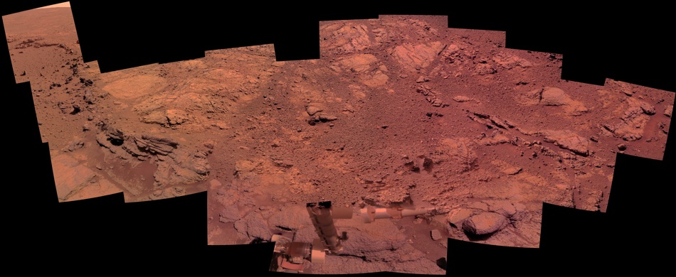
Wow, this flat light-toned outcrop is really looking like something new to me:
http://qt.exploratorium.edu/mars/opportuni...5M1.JPG?sol3071
But I thought there was something familiar about it... then it occured to me:
Click to view attachment

http://qt.exploratorium.edu/mars/opportuni...5M1.JPG?sol3071
But I thought there was something familiar about it... then it occured to me:
Click to view attachment
Looks at wall...
"Who did that plastering job? Right bunch of cowboys, by the looks of it..."
Click to view attachment

"Who did that plastering job? Right bunch of cowboys, by the looks of it..."
Click to view attachment
QUOTE
then it occured to me...
aeolian erosion is scalable?Wonderful lithologies here. I'd like to know more about those (lower in the section) outcrops we saw on the way here (Sol-3051-ish). And there appears to be several interesting exposures all the way to the top of Shoemaker Ridge.
So much to see.
QUOTE (StephenGFX)
I have combined Tesh's latest map with your posted image:
On the image files I use here I generally have several "annotation" overlays so that the main image doesn't get cluttered. I can view any, all or none of the layers.--Bill
QUOTE (Stu @ Sep 13 2012, 06:21 PM)
"Who did that plastering job?
Actually I was thinking it looks quite clay-like. Anybody else?
It does sort of look like a form of mudstone, doesn't it?
Actually, of course, it's just the remnants of the concrete floor of the old thoat pen that used to stand here...
-the other Doug
Actually, of course, it's just the remnants of the concrete floor of the old thoat pen that used to stand here...
-the other Doug
I think it looks a lot like dried plaster/gypsum/calcium sulphate. This from Wikipedia:
"The hemihydrate (CaSO4·~0.5H2O) is better known as plaster of Paris, while the dihydrate (CaSO4·2H2O) occurs naturally as gypsum."
On a related topic, I found this conference paper on simulated wind erosion of soft sedimetary rocks. Some of the pictures in the paper look like what the rover is seeing on Mars. In particular the rocks developed a finely laminated look, and also they formed pedestals or fins.
Rossman-Wilson-Shieber 2012 LPSC paper
QUOTE (dvandorn @ Sep 13 2012, 06:43 PM)
It does sort of look like a form of mudstone, doesn't it?
The pamcam ratios seem to imply that this (unnamed?) target is primarily basaltic mud with teeny tiny sparkly bits. My bet is that this is a localised mudstone formed from material eroding from higher up CY - clay rich possibly, but how could we tell? I think we saw mudstone (shaley siltstone) around Cortez, probably from material eroded from the shoemaker formation. Still, this is a really nice place for Oppy to soak up the rays while brushing and then getting some APXS information. Unfortunately we will probably have to await the next LPSC to get detail.
IMO the spherule layer is more interesting. Glass is comparatively vulnerable to erosion and the apparent differential erosion here will probably tell us something in hindsight. Is this a deposit arising from the Endeavour impact or was it a pre-existing uplift? The apparent dip could possibly imply so. If pre-existing was it an original placement, or the result of erosion/transportation and deposition with strong lithification of the matrix. Since the Miyamoto ejecta blanket in this area would have been hundreds of metres thick and massive channels cut this ejecta blanket to the south all options seem equally likely. My head hurts.
here is my take on the 'mud floor' here at CY
Click to view attachment
Click to view attachment
It's labelled "Whitewater Lake".
QUOTE (PDP8E @ Sep 13 2012, 08:15 PM)
here is my take on the 'mud floor' here at CY
Looks like desert varnish.
This new unit is indeed interesting. I think that the unusual appearance is due to aeolian erosion on a material with different characteristics than what we have become accustomed to. For the time being I'm thinking of it as a "fine-grained material with unknown affinitities".  What intrigues me is the pattern of fractures. I see that the IDD is setting up on it so perhaps we'll be getting MIs soon.
I see that it has been named "Whitewater Lake". Appropriate? I've had a soft spot for the Whiterock Formation for the last 30 years and I'm glad they didn't adopt _that_ name.
As we've discussed before, Serpens, this area is going to prove to be horrendously complex. No doubt there will be much arm-waving and pacing of the floor going around. I've even started thinking of the spherules as "spherules of unknown affinities".
--Bill
What intrigues me is the pattern of fractures. I see that the IDD is setting up on it so perhaps we'll be getting MIs soon.I see that it has been named "Whitewater Lake". Appropriate? I've had a soft spot for the Whiterock Formation for the last 30 years and I'm glad they didn't adopt _that_ name.
As we've discussed before, Serpens, this area is going to prove to be horrendously complex. No doubt there will be much arm-waving and pacing of the floor going around. I've even started thinking of the spherules as "spherules of unknown affinities".
--Bill
It appears they are not hematitic...
-the other Doug
-the other Doug
Phew - relief! The 'just blueberries' hypothesis was giving me headaches the more I tried to believe it.
Not just here but at NASA too it seems. This is a big moment for sure. I hope you (UMSF geologists plural) will continue to share your arm-waving with the rest of us despite the complexity of the subject in view.
QUOTE (Bill Harris @ Sep 14 2012, 04:10 AM)
This new unit is indeed interesting. [ . . . ] No doubt there will be much arm-waving and pacing of the floor going around.
Not just here but at NASA too it seems. This is a big moment for sure. I hope you (UMSF geologists plural) will continue to share your arm-waving with the rest of us despite the complexity of the subject in view.
QUOTE (marsophile @ Sep 14 2012, 09:07 PM)
From Steve Squyres: "we have a wonderful geological puzzle in front of us. We have multiple working hypotheses, and we have no favorite hypothesis at this time. It's going to take a while to work this out, so the thing to do now is keep an open mind and let the rocks do the talking."
I love this. We did have this kind of quote since nearly Sol 1, then once in a while but didn't have it again for years!
To what extent are the scientists able to work 'both sides of the field', ie sit in and contribute to both Curiosity and Opportunity SOWG meetings? Are some of them locked in on Mars time, or is that just the operations personnel? I can imagine some researchers who are tied down atm with stuff like calibrating instruments on MSL but would like to be able to assist in the planning Oppy's science campaign at this location.
Actually, this feels a lot like when Spirit arrived at the Columbia Hills and immediately found Pot of Gold rock. And Squyres said it was like starting the mission up fresh.
This feels like we're starting a new exploration all over again, here...
-the other Doug
This feels like we're starting a new exploration all over again, here...
-the other Doug
Luv the plaster patch.....and cool that we are not seeing another blueberries site.
Participatory explorartion at it's best..... from a guy who remembers Mariner 4, never would have imagined how we can now all be a part of this journey.
Indeed a new exploration has begun.....
LUV THIS!!! (Have I said that before
Craig
Participatory explorartion at it's best..... from a guy who remembers Mariner 4, never would have imagined how we can now all be a part of this journey.
Indeed a new exploration has begun.....
LUV THIS!!! (Have I said that before
Craig
Well these new "berries" are blue (at least as much as the other ones).
I vaguely remember seeing similar layers of impact spherules in the NW Australia Pilbara mining leases (longer ago than I really care to contemplate). Regardless of the formative process for the spherules the matrix seems highly resistant to aeolian erosion. This does imply aqueous alteration/strong lithification which could occur within a directly emplaced layer or through transportation and accumulation.
Just as an aside...
In the JPL release on Kirkwood, I really like the fact that the image they use is credited to:
NASA/JPL-Caltech/Cornell Univ./ USGS/Modesto Junior College
Looks like some enthusiastic, future UMSF'ers have been busy
In the JPL release on Kirkwood, I really like the fact that the image they use is credited to:
NASA/JPL-Caltech/Cornell Univ./ USGS/Modesto Junior College
Looks like some enthusiastic, future UMSF'ers have been busy
A particularly nice shot of the uphill detour: http://qt.exploratorium.edu/mars/opportuni...M5P1977R0M1.JPG
One of the first things I noticed working with images from this location is that there is an excess of yellow in the raw IRB tri-color images. This is anomalous. I remember that previously I noticed this same color bias at the stop at Santa Maria Crater. At the time I thought that this crater penetrated the Burns Fm and disturbed the basal unit underlying the Burns (basal, in this case, being the geologic unit underneath the Meridiani playa deposits). At Santa Maria Oppy also encountered blue, burple and light-toned rocks of "unknown affinities" that, unfortunately, we did not have time to examine closely.
I supect that this basal unit is the pre-Endeavour surface, highly weathered and comprised of a mish-mash of various impactites, ejectites and other residual units. This may well be the source of the holy-grail phyllosilicates of which we seeketh.
There are some of the Santa Maria images at my Mars photosite (listed in my Sig)
--Bill
QUOTE (Astro0 @ Sep 14 2012, 11:37 PM)
Just as an aside...
In the JPL release on Kirkwood, I really like the fact that the image they use is credited to:
NASA/JPL-Caltech/Cornell Univ./ USGS/Modesto Junior College
Looks like some enthusiastic, future UMSF'ers have been busy
In the JPL release on Kirkwood, I really like the fact that the image they use is credited to:
NASA/JPL-Caltech/Cornell Univ./ USGS/Modesto Junior College
Looks like some enthusiastic, future UMSF'ers have been busy
As a followup to Astro0 on the Modesto Junior College credit, Professor Joel Hagen has been named an official 'MER Collaborator' by NASA for his imaging work. A nice writeup on Prof. Hagen is in the college's "Vista and Voices" news letter (pdf) at this link: (search for JPL, or Hagen)
www.mjc.edu/general/president/2011springvistasvoices.pdf
Congratulations to Prof.Hagen for his outstanding work!
I took some times to stitch this kinda huge mosaic of these very interestings outcrops. Do this place have a name ?
Some frames are missing, they will surely be available in the next few days.
Some frames are missing, they will surely be available in the next few days
.
QUOTE (PDP8E @ Sep 15 2012, 07:03 PM)
Congratulations to Prof.Hagen for his outstanding work!
*Clap clap*
And yes the news about these spherules hit ScienceDaily now also.
So it's not just us on this forum who think this is noteworthy.
Bravo Ant 103 : this is a nice and great mosaic !
Funny thing : we did our processings at the same time !
This is my careful processing and own interpretation of colours there and the "fin" ridge looks really grey (NOT blue) in its most interesting part...
A very unusual geological formation indeed... Enjoy !
Click to view attachment
Funny thing : we did our processings at the same time !
This is my careful processing and own interpretation of colours there and the "fin" ridge looks really grey (NOT blue) in its most interesting part...
A very unusual geological formation indeed... Enjoy !
Click to view attachment
QUOTE (Bill Harris @ Sep 15 2012, 04:14 PM)
At Santa Maria Oppy also encountered blue, burple and light-toned rocks of "unknown affinities" that, unfortunately, we did not have time to examine closely.
I supect that this basal unit is the pre-Endeavour surface, highly weathered and comprised of a mish-mash of various impactites, ejectites and other residual units. This may well be the source of the holy-grail phyllosilicates
I supect that this basal unit is the pre-Endeavour surface, highly weathered and comprised of a mish-mash of various impactites, ejectites and other residual units. This may well be the source of the holy-grail phyllosilicates
Every word of your post sounds eminently plausible to me. It's a long shot but I wonder if we saw any of the older low-iron spherules at Santa Maria but passed over them as 'ordinary' Meridiani blueberries at the time?
Once we get to know these older rocks in detail through exploring Endeavour we may even find that we saw the odd fragment around Victoria.
Did I dream this, or was there some mention of a phyllosilicate detection (CRISM I guess) on the unexplored side of Victoria, after we had left?
Maybe you're thinking of this? http://www.google.co.uk/url?sa=t&rct=j...yaQ&cad=rja
Following up on an earlier comment:
Perhaps this mud-like stuff is wet (or icy) when buried and only dries out where exposed.
QUOTE (Bill Harris @ Sep 14 2012, 04:10 AM)
"fine-grained material with unknown affinitities". What intrigues me is the pattern of fractures.
Perhaps this mud-like stuff is wet (or icy) when buried and only dries out where exposed.
QUOTE (ngunn @ Sep 15 2012, 08:25 PM)
Maybe you're thinking of this?
That's it, thanks. So not phyllosilicates.
Sometimes we need to remind ourselves of the scale of this feature.
Click to view attachment
Taking a step back, Ant's superb stitch provides some perspective although I do prefer Viking Mar's color treatment. But my xmas wish list would include a climb to the top of CY from here to check out the nature of the intervening outcrops and hopefully connect a few dots. Are the spherules in this apparent mudstone/siltstone concretions as opposed to the apparent impact generated layer? The distribution does seem to make this possible. If they are is tdemko right that these are attributable to the Burnes formation groundwater event, or does their composition indicate something else?
QUOTE (ngunn)
Perhaps this mud-like stuff is wet (or icy) when buried and only dries out where exposed.
Here, near the equator, solid or liquid water is not likely. The rock looks like mud/plaster because of the way it's eroded.QUOTE
But my xmas wish list would include a climb to the top of CY from here to check out the nature of the intervening outcrops and hopefully connect a few dots.
Exactly, Serpens. This geologic column starts down at the bench and can be investigated all the way to the hilltop (and beyond). We need more puzzle-pieces, and these pieces are not always big spectacular outcrops.Take a look at the color HiRISE image I posted the other day to see what can be seen onthe way up:
http://www.unmannedspaceflight.com/index.p...st&id=28072
--Bill
Right. Gotcha. Step back a bit further.
Click to view attachment
The sediment (mudstone or whatever) seems to be localised and follows the contour - pooled against the impact spherule layer?
Oooh - those perpendicular (unloading joints?) are just over there and that old crater just to the NW could maybe perhaps provide a roadcut. Let someone else break an unimportant distance record - I like this place.
QUOTE (fredk @ Sep 15 2012, 11:13 PM)
That's it, thanks. So not phyllosilicates.
No, but its colour and lustre I guess makes kieserite a candidate for Bill's 'anomalous' Santa Maria stuff. It could be a marker for the layer where the two different rock chemistries meet. If so, it should be present here at Endeavour too.
Bill - no water or ice at the equator even, say, 10 or 20m down? Do we know this?
QUOTE (vikingmars @ Sep 15 2012, 11:42 AM)
A very unusual geological formation indeed... Enjoy !
In looking at your excellent and evocative rendering, I can't help imagining that an impact sheared off the entire top of the Fin formation. Nah, it can't be!
QUOTE
Bill - no water or ice at the equator even, say, 10 or 20m down? Do we know this?
I'm presuming. <shrug> We really won't know til we drill the area, right? At or near the surface, no. At depth, possibly. Get heat from the thermal gradient, pressure from the depth of water and voila, liquid water. Mineralized, nasty by terrestrial standards, but water nonetheless.Let me change that nay to a definite maybe?
--Bill
QUOTE (ngunn @ Sep 16 2012, 04:03 AM)
No, but its colour and lustre I guess makes kieserite a candidate for Bill's 'anomalous' Santa Maria stuff. .....Bill - no water or ice at the equator even, say, 10 or 20m down? Do we know this?
Well kieserite is pretty unstable and is a good indicator that there has been no water since exposure from any source. Was any kieserite identified near the smectite signature on CY? Bill's yellow could be kieserite, but then again nontronite is yellowish. From ngunn's link there are polyhydrated sulphates around CY. Anyone have any idea what the hydration state is thought to be and were they Mg or Ca?
But the purplish tinge to Bills anomalous stuff is another thing and could be as simple as a Basaltic breccia precursor, anoxic environment with little if any initial organic carbon. Agatha Christie mysteries are a doddle compared to this place..
QUOTE (TheAnt @ Sep 15 2012, 09:34 PM)
And yes the news about these spherules hit ScienceDaily now also.
So it's not just us on this forum who think this is noteworthy.
So it's not just us on this forum who think this is noteworthy.
Definitely hit the big news:
http://cosmiclog.nbcnews.com/_news/2012/09...an-mystery?lite
To continue discussion of the fine-grained 'mud floor':
Almost 6 years ago I proposed this scenario: The Victoria impact fluidises an ice-rich layer buried, say 100-200 metres below the surface. Some of this material drains out from under the crater rim and collects as a temporary lake in the centre of the crater. The crater rim collapses in an irregular pattern into the void created, forming the cliffs and bays we see now.
At the time there was no evidence for an under-layer beneath Victoria, let alone one with the right properties and at the right depth, so unsurprisingly the idea got no support here and we moved on. Now, though, I think this fine-grained unit is a potential candidate for the stuff that fluidised. Dry materials can fluidise when shocked, but it happens a whole lot easier if there's even a little water present. (It also helps with clay-making.)
If the fine-grained unit was patchy to start with (not unreasonable in a "mish-mash of various impactites, ejectites and other residual units") sapping would also have been irregularly distributed, possibly determining the outlines of the capes and bays of Victoria and her similarly endowed twin some kilometres to the south.
Did somebody mention arm-waving?
QUOTE (ngunn @ Sep 15 2012, 09:56 PM)
Perhaps this mud-like stuff is wet (or icy) when buried and only dries out where exposed.
QUOTE (Bill Harris @ Sep 16 2012, 05:32 AM)
Let me change that nay to a definite maybe?
Almost 6 years ago I proposed this scenario: The Victoria impact fluidises an ice-rich layer buried, say 100-200 metres below the surface. Some of this material drains out from under the crater rim and collects as a temporary lake in the centre of the crater. The crater rim collapses in an irregular pattern into the void created, forming the cliffs and bays we see now.
At the time there was no evidence for an under-layer beneath Victoria, let alone one with the right properties and at the right depth, so unsurprisingly the idea got no support here and we moved on. Now, though, I think this fine-grained unit is a potential candidate for the stuff that fluidised. Dry materials can fluidise when shocked, but it happens a whole lot easier if there's even a little water present. (It also helps with clay-making.)
If the fine-grained unit was patchy to start with (not unreasonable in a "mish-mash of various impactites, ejectites and other residual units") sapping would also have been irregularly distributed, possibly determining the outlines of the capes and bays of Victoria and her similarly endowed twin some kilometres to the south.
Did somebody mention arm-waving?
In my opinion the MI of Whitewater Lake must be placed upside down due to the shadows in the upper left side (the sun comes from the right side):
Click to view attachment
Link to image
Cheers, Udo
Click to view attachment
Link to image
Cheers, Udo
After all these years of being faithful to "McKay" - spotted on the side of Homeplate by Spirit, about a million years ago - I think I have a new favourite Mars rock...
Click to view attachment
Full reverse, Chewie...!!!
Click to view attachment
Full reverse, Chewie...!!!
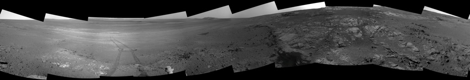
Sol 3066 Navcam pan. I love the fact of seeing the rover tracks coming from somewhere *of the crater bottom*.
Stu! Hay lapa no ya, Stu!

Stu! Hay lapa no ya, Stu!
This is a "lo-fi" version of our main content. To view the full version with more information, formatting and images, please click here.