Full Version: Cape York - Shoemaker Ridge and the NE traverse
If I didn't know better I'd say Cassini took those photos!
Scott Maxwell tweeted 10 hours ago:
"We now officially have winter plans: heading for the north side of Cape York. Nice northerly (sunny) tilts + good science = our winter home."
There seem to be large rock outcrops up there and so we can expect some nice color panoramas throughout the winter.
"We now officially have winter plans: heading for the north side of Cape York. Nice northerly (sunny) tilts + good science = our winter home."
There seem to be large rock outcrops up there and so we can expect some nice color panoramas throughout the winter.
Here's a mosaic of the "post-drive" navcams from today's batch corresponding to sol 2749.
Click to view attachment
Click to view attachment
QUOTE (PaulM @ Oct 19 2011, 03:44 AM) 
Scott Maxwell tweeted 10 hours ago:
"We now officially have winter plans: heading for the north side of Cape York. Nice northerly (sunny) tilts + good science = our winter home."
There seem to be large rock outcrops up there and so we can expect some nice color panoramas throughout the winter.
"We now officially have winter plans: heading for the north side of Cape York. Nice northerly (sunny) tilts + good science = our winter home."
There seem to be large rock outcrops up there and so we can expect some nice color panoramas throughout the winter.
You bet! We'll sniff out those phyllosilicates on the way back south after winter is over... we just can't support the amount of activity and power that MB/APXS/MI'ing would require through the winter. We had some epically bad timing in getting to Cape York right as we hit Fall...
No biggie, there are great science things to get done while we map out the north side of CY and while we park for Solstice. (A park that, really, shouldn't last too long.)
-m
Hmmm... Solstice is still over five months away - I wonder what current projections are saying about when we may need to park.
Too bad they couldn't find a nice north-facing clay-bearing outcrop to park on and MB for months at a time...
Too bad they couldn't find a nice north-facing clay-bearing outcrop to park on and MB for months at a time...
The power must be really bad if they are thinking about parking already.
Low, perhaps; bad, not really.
As far as I understood, they are predicting potentially low power around the winter solstice. Being that the case, you should start looking for a "parking area" while there's enough power to drive and absolutely not when you are already low on power.
As far as I understood, they are predicting potentially low power around the winter solstice. Being that the case, you should start looking for a "parking area" while there's enough power to drive and absolutely not when you are already low on power.
It's probably CYA ("Cover Your Anterior") contigency planning. Here we have a geriatric Rover, decreased Winter light levels, dusty solar panels, a wheel motor wih a history of elevated current draw and a defunct sister at Gusev, so they're being cautious.
Being no Spring Chicken, were I out on Mars doing this traverse today I'd certainly pace myself...
--Bill
Being no Spring Chicken, were I out on Mars doing this traverse today I'd certainly pace myself...
--Bill
QUOTE (fredk @ Oct 19 2011, 11:15 PM)
Hmmm... Solstice is still over five months away - I wonder what current projections are saying about when we may need to park.
But aphelion is sooner, and near the Martian equator, that is as big a deal. With extra dust on the arrays and extra dust above them, and the sort-of sine-wave slow approach to the minima, power to support driving to a lily pad goes away sooner rather than later. Add a local SE facing slope and it is not like lily pads are dotting the landscape, so they would need to be found and proven to be real (easy to get false positives from a DEM). Hmm, almost convinced myself there....
Throw in an unexpected sand trap or mechanical difficulties and waiting 'til the last weeks, or even last months, to look for the best wintering spot is a recipe for disaster. Better to be prudent with foresight than regretful with hindsight. Besides, all those who wanted desperately to check out that "mystery crack" at the North end of Cape York must be happy, whatever the reason for heading North.
360x90 Navcam anaglyph sol 2750
QUOTE (Sunspot @ Oct 19 2011, 11:33 PM)
The power must be really bad if they are thinking about parking already.
This statement really does baffle me.
Do you not remember the mad rush before Winter Haven 1 on the SE side of Home Plate or WH3 on it's Northern slope.
Is Troy really that long ago that you've just forgotten how we lost Spirit?
Or maybe you always let the fuel light on your car come on, drive another 50 miles and let the engine start spluttering before even thinking about a gas station.
I don't, and fortunately, neither do the MER folks.
QUOTE (Sunspot @ Oct 20 2011, 03:33 AM)
The power must be really bad if they are thinking about parking already.
Besides what's already been said, Opportunity will not be "parking already". The idea is to find an area where exploration can continue with a minimum of energy worries and where a good parking spot is close at hand if it becomes necessary.
QUOTE (Deimos @ Oct 20 2011, 01:38 PM)
But aphelion is sooner, and near the Martian equator, that is as big a deal.
Of course, thanks for reminding me of that. At Oppy's latitude of about 2 degrees S, the Sun would be only marginally lower (4 degrees, actually) in the north during (southern) winter solstice than it is in the south during summer solstice. So ignoring the other effects (distance from Sun, dust, tilt), winter solstice wouldn't be too much worse power-wise than summer solstice.
I can see perihelion having a big impact on available energy. But I wonder as well about the temperatures. Presubably there's a "perihelion winter" effect, even though we're sitting almost on the equator so normally you'd expect only subtle seasons. So perhaps we also have to factor in a greater need for power to keep heaters running through perihelion.
QUOTE (Sunspot @ Oct 20 2011, 03:33 AM)
The power must be really bad if they are thinking about parking already.
They're pretty open about the dust/insolation/power numbers here:
http://marsrovers.nasa.gov/mission/status_...rtunityAll.html
QUOTE
With her solar arrays dustier and atmospheric opacity higher than in past years, the winter will be more challenging. So, Opportunity has been surveying regions with favorable northerly tilts so she can spend the winter months actively exploring. ...
As of Sol 2744 (Oct. 13, 2011), solar array energy production was 316 watt-hours with an atmospheric opacity (Tau) of 0.791 and a solar array dust factor of 0.498.
As of Sol 2744 (Oct. 13, 2011), solar array energy production was 316 watt-hours with an atmospheric opacity (Tau) of 0.791 and a solar array dust factor of 0.498.
That watt-hour number is not significantly worse than the previous few weeks. It is substantially worse than the previous months.
QUOTE (Deimos @ Oct 20 2011, 08:38 AM)
But aphelion is sooner, and near the Martian equator, that is as big a deal. With extra dust on the arrays and extra dust above them, and the sort-of sine-wave slow approach to the minima, power to support driving to a lily pad goes away sooner rather than later. Add a local SE facing slope and it is not like lily pads are dotting the landscape, so they would need to be found and proven to be real (easy to get false positives from a DEM). Hmm, almost convinced myself there....
Like this post. Boy did I ever feel that sinewave after Labor Day. Walking the dogs in the dark now.
Another factor is that the areas we would most like to explore have a southern tilt. Unfortunately, a tilt in the wrong direction produces a change of greater magnitude than a tilt in the right direction in this case.
I guess what would be really helpful would be for one of the rover drivers to talk to a MER blog about the team's plans for the winter, and maybe even ID the actual spot on Cape York they're heading for...
Oh, look...
http://roadtoendeavour.wordpress.com/2011/...chat-with-scott

Oh, look...
http://roadtoendeavour.wordpress.com/2011/...chat-with-scott
... and so ends three pages of hand-wringing and speculation. Thanks Stu for bringing us those most excellent questions and and the answers straight from the horse's mouth.
Excellent interview, thanks Stu
yes, excellent interview, its great to get such detail!
Recent posts bring up what i remeber being concerned about -now YEARS ago- about limits to Oppy's lifespan in spite of the solar panel condition due to some other components long past warranty (degradation of battery and RTG component warmers, others?) but i havent heard any discussion about those things for years and couldnt find anything relevant searching UMSF threads. Yes im Oppytomistic, but can anyone address those concerns?
Recent posts bring up what i remeber being concerned about -now YEARS ago- about limits to Oppy's lifespan in spite of the solar panel condition due to some other components long past warranty (degradation of battery and RTG component warmers, others?) but i havent heard any discussion about those things for years and couldnt find anything relevant searching UMSF threads. Yes im Oppytomistic, but can anyone address those concerns?
QUOTE (atomoid @ Oct 20 2011, 09:45 PM)
can anyone address those concerns?
Probably not. It's not like there are statistics from the last 10,000 rovers. And I doubt the RHUs are too much a concern for the first decade.

Quoting Scott on the view across Endeavour:
itll take me a while to get used to
the view, to really internalize it.
I'm sure some of us share this feeling. I was wondering (fredk) if we have traversed far enough along Cape York for a good long baseline anaglyph showing the central mound and far rim features in 3D?
itll take me a while to get used to
the view, to really internalize it.
I'm sure some of us share this feeling. I was wondering (fredk
) if we have traversed far enough along Cape York for a good long baseline anaglyph showing the central mound and far rim features in 3D?
Thank you Stu (and Scott!) for a well reported interview on a subject that most us just can't get enough info about.
You're welcome - and I should say here that two of the questions were Dan's, so he should be thanked too
So... northwards we go... and there's some very interesting terrain up ahead...
Click to view attachment
So... northwards we go... and there's some very interesting terrain up ahead...
Click to view attachment
QUOTE (ngunn @ Oct 21 2011, 11:16 AM)
I was wondering (fredk ) if we have traversed far enough along Cape York for a good long baseline anaglyph
Yep! Thanks for pointing this out - it didn't even occur to me to try this.) if we have traversed far enough along Cape York for a good long baseline anaglyphHere are two long baseline anaglyphs, made from 2710/2742 and 2710/2746 navcam mosaics from mhoward. Warning: these are probably for advanced anaglyphists, and may induce headaches etc:
Click to view attachment
Click to view attachment
QUOTE (fredk @ Oct 21 2011, 07:54 AM)
Warning: these are probably for advanced anaglyphists, and may induce headaches etc:
As an advanced anaglyphist it just so happens that I keep a bottle of Irish anaglyph-headache medication in my bottom desk drawer for occasions such as this (and many others).
QUOTE (fredk @ Oct 21 2011, 08:54 AM)
Here are two long baseline anaglyphs, made from 2710/2742 and 2710/2746 navcam mosaics
Those are really cool. Worth the headache.
Speaking of anaglyphs, here's the usual Navcam anaglyph for sol 2751.
Thanks for the great interview, Stu! Maxwell's mention of the C6 destination area makes sense - that corresponds to the left side of the top of CY that we saw on approach to Endeavour, as seen in this view from 2669:
http://marsrovers.jpl.nasa.gov/gallery/all...N5P1797R0M1.JPG
The MSL connection with winter haven plans was interesting too. But we did have this comment in the latest official update:
http://marsrovers.jpl.nasa.gov/gallery/all...N5P1797R0M1.JPG
The MSL connection with winter haven plans was interesting too. But we did have this comment in the latest official update:
QUOTE
The plan ahead is to continue to drive toward the north end of Cape York and to capture any opportunistic in-situ (contact) science alone the way. Light-toned veins in the rock outcrop, possibly fracture fill, have been seen around Cape York. If Opportunity encounters one of these veins along the way, a brief robotic-arm science campaign may be conducted.
QUOTE (fredk @ Oct 21 2011, 04:54 PM)
long baseline anaglyphs
Very interesting - thanks for doing those. The only bit I can't quite get to work is the leftmost end where the effective baseline is shorter and everything is just too bland topography- and contrast-wise for the eye to find a 'key'. I hope a pancam version of at least the middle part becomes possible soon.
QUOTE (Phil Stooke @ Oct 21 2011, 12:18 PM)
This is mhoward's sol 2750 pan in circular form.
Extracted from the anaglyph! Cool, you just doubled my efficiency.

You're welcome! Yes, it was extracted, or as I prefer to think of it, stolen, from the anaglyph... after all, each anaglyph is just two panoramas. In fact I used one to patch the other to get rid of a bad bit on the horizon.
Phil
Phil
QUOTE (Mike)
Extracted from the anaglyph! Cool...
Easy to do-- use an image editor to separate an RGB image into the component red, green and blue channels. The RED channel is one stereo channel, the GREEN and BLUE (combined to make cyan of the anaglyph) channels are two identical grayscale images. Discard one. You end up with a right and a left grayscale stereo pair which can be used to make an x-eyed stereo image.--Bill
...and speaking of anaglyphs, been working on one to bring out details in the area where we now know Oppy will be spending the winter...
Click to view attachment
Click to view attachment
Brilliant! When we have to be wintered in C6 there seems to be an alternative hideout in D5.
But stare as I might I can't see any significant relief in Dagger Valley.
But stare as I might I can't see any significant relief in Dagger Valley.
QUOTE (Phil Stooke @ Oct 21 2011, 02:00 PM)
after all, each anaglyph is just two panoramas
I meant that it's good to know you can extract them from the anaglyph if wanted, because posting the left and right as well as the anaglyph seems like overkill sometimes. The main reason I've been posting both left and right is so that you can encirclify them.
relief map, just what the doctor ordered, Mars is truly a World of Wonders!!
im still wondering how many years ago Oppy's battery shoudl have died, wish my laptop would fare as well!
im still wondering how many years ago Oppy's battery shoudl have died, wish my laptop would fare as well!
I see what you mean about posting the extra pans... certainly from my point of view I don't need the additional raw panoramas, unless the quality is significantly improved I suppose... but others may prefer a single pan.
Quite the team we have here!
Phil
Quite the team we have here!
Phil
Lot'sa of new placenames the past few days:
02743 p2410 Sheba
02749 p2414 Onverwacht
02751 p2560. Hooggenoeg
02751 p2561 Tjakastad
02751 p2562 Moodies
--Bill
02743 p2410 Sheba
02749 p2414 Onverwacht
02751 p2560. Hooggenoeg
02751 p2561 Tjakastad
02751 p2562 Moodies
--Bill
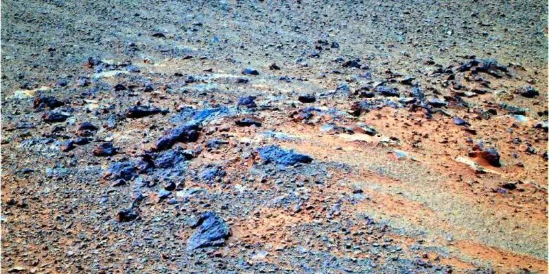
Outcrop Onverwacht on Shoemaker Ridge
L257 Sol-2749
This is significant-- note the _brown_ zones in the rocks and the residiuum.
--Bill
L257 Sol-2749
This is significant-- note the _brown_ zones in the rocks and the residiuum.
--Bill
Excellent anaglyph, Stu, you really did bring out the fine details. What is the vertical scale factor?
I recall that at some point on the long traverse from Victoria we were surprised to figure out just how little genuine relief there is on Cape York.
I recall that at some point on the long traverse from Victoria we were surprised to figure out just how little genuine relief there is on Cape York.
Well, CY's about 800 metres long, and the highest parts (N part) stick very roughly 10ish metres above the slope into Endeavour.
How the anaglyph looks depends on your monitor size, distance from monitor, etc, but most likely the relief looks heavily exagerated.
How the anaglyph looks depends on your monitor size, distance from monitor, etc, but most likely the relief looks heavily exagerated.
No vertical exaggeration at my end. I just took the anaglyph from this HiRISE page:
http://hirise.lpl.arizona.edu/PSP_010341_1775
...and worked on it, basically just sharpening it up, boosting the contrast and changing the gamma values etc until finer details and features jumped out a little more. Not sure what vertical stretching the HiRISE anaglyphs have.
http://hirise.lpl.arizona.edu/PSP_010341_1775
...and worked on it, basically just sharpening it up, boosting the contrast and changing the gamma values etc until finer details and features jumped out a little more. Not sure what vertical stretching the HiRISE anaglyphs have.
QUOTE (Bill Harris @ Oct 22 2011, 04:42 AM)
Lot'sa of new placenames the past few days:
02743 p2410 Sheba
02749 p2414 Onverwacht
02751 p2560. Hooggenoeg
02751 p2561 Tjakastad
02751 p2562 Moodies
--Bill
02743 p2410 Sheba
02749 p2414 Onverwacht
02751 p2560. Hooggenoeg
02751 p2561 Tjakastad
02751 p2562 Moodies
--Bill
So, we moved from Canada (Tisdale and co.) to South Africa.
A search on the names point to the latter.
----
On a different matter, we are way after Shoemaker Ridge so I though it would be ok to update the thread name: Cape York - Shoemaker Ridge and the NE traverse
(
QUOTE (fredk @ Oct 22 2011, 05:31 PM)
Well, CY's about 800 metres long,
Regarding a recent comment from Scott about feeling Endeavour size, CY's = Victoria's.
If I may, some more size comparisons here...
http://roadtoendeavour.wordpress.com/2011/...ng-up-cape-york
http://roadtoendeavour.wordpress.com/2011/...ng-up-cape-york
Here's a pseudo-false-color anaglyph of Onverwacht (sol 2749). Painful, I know. The red-cyan separation of anaglyphs doesn't play well with real (or even false) color, especially with a color scheme which is skewed toward red.
If anyone out there has a iPhone/iPod Touch with a my3D, the latter two images are compatible with that device.
If anyone out there has a iPhone/iPod Touch with a my3D, the latter two images are compatible with that device.
Here's a 90-degree-wide view facing east around sol 2749, showing the context of Onverwacht:
This is a "lo-fi" version of our main content. To view the full version with more information, formatting and images, please click here.