Help - Search - Members - Calendar
Full Version: Cape York - Shoemaker Ridge and the NE traverse
Unmanned Spaceflight.com > Mars & Missions > Past and Future > MER > Opportunity
Pages: 1, 2, 3, 4, 5, 6, 7, 8, 9, 10, 11
fredk
It looks like we're continuing our slope survey with another good drive NE on 2744. Although judging from this hazcam:
http://qt.exploratorium.edu/mars/opportuni...0M1.JPG?sol2744
you could be forgiven for thinking we've been transported back to the smooth terrain around Victoria! laugh.gif
Tesheiner
63m NNE, actually.
And, well, I think this navcam gives the same impression too: http://qt.exploratorium.edu/mars/opportuni...JMP0613L0M1.JPG
Stu
Interesting feature coming into view for Oppy now...

Click to view attachment

And stretched...

Click to view attachment

At first I thought that might be the more northerly parts of CY, but looking at Google Mars I'm now wondering if that dark tongue of material is actually darker ground sloping into Endeavour on the northern side of Artemis Crater..?
Bill Harris
I'm thinking (tentatively, I've been turned around a lot lately) that the line of dark rocks in the upper right of this Navcam marks the near rim of the "summit crater" and that crater extends off to the left.

Sol-2744 Navcam:

http://qt.exploratorium.edu/mars/opportuni...JMP0613L0M1.JPG

That being the case, we are in the middle of the CRISM clay area. The soil at our wheels is quite different and remarkable, as seen in the Pan-, Nav- and Hazcams. T'would be a perfect opportunity for a "systematic foreground" image...

--Bill
Jam Butty
Sol 2744 right pancam stitch.
I assume this is the summit crater and the area to the east of it.

Click to view attachment
fredk
QUOTE (Stu @ Oct 14 2011, 12:58 AM) *
Artemis Crater..?

I don't recall hearing that name - what crater is that and where'd you hear it, Stu?
fredk
Fascinating topography here, for sure:
Click to view attachment
Notice how the ripples drape into the near crater.
Stu
QUOTE (fredk @ Oct 14 2011, 04:10 AM) *
I don't recall hearing that name - what crater is that and where'd you hear it, Stu?


Sorry, meant to say "Antares"...

http://marsrover.nasa.gov/gallery/press/op...traverse_br.jpg

rolleyes.gif
jvandriel
The complete Pancam L2 view on Sol 2744.

Jan van Driel

Click to view attachment
Stu
3D view...

Click to view attachment
mhoward
Sol 2744 Pancam anaglyph mosaic
fredk
QUOTE (Stu @ Oct 14 2011, 07:07 AM) *
Sorry, meant to say "Antares"...

Ah, gotcha. Yep, I'm pretty sure that "dark tongue" is farther up the Endeavour rim, well beyond CY.
Phil Stooke
A bit delayed, but here is the sol 2742 panorama from mhoward in circular format.

Phil

Click to view attachment
Stu
New rocks, everyone... smile.gif

Click to view attachment

Click to view attachment
Jam Butty
color flicker gif
sol 2743, L257 R2-1

Click to view attachment
mhoward
QUOTE (Stu @ Oct 15 2011, 07:30 PM) *
New rocks, everyone... smile.gif


The outcrop viewed on sol 2743 is called "Sheba," apparently.
Bill Harris
The L257, L456 and R721 Pancams from command sequence P2410 are indeed "Sheba" and might just be the source of the clay signature.

--Bill
Stu
Quick (well, I say 'quick'; been working on it for ages but can't get the colours to match yet!) colour view of "Sheba"...

Click to view attachment
mhoward
Pancam anaglyph mosaic for sol 2746. I was a bit lost, so I marked North and Northeast; that helped me line up features with the map better.
fredk
Well, this is it: in the foreground is one of the biggest outcrops in the heart of the CRISM signature:
Click to view attachment
Some interesting bright outcrops farther out on the right side of the frame: those are on the rim of the largest crater on CY (the ancient-looking, mostly filled one).
mhoward
Here's what's available of the Navcam
Eutectic
Path to sol 2746 + CRISM overlay -- overlay is approximate.

Click to view attachment
CosmicRocker
It might be useful to see those CRISM mineralogical anomalies overlain on a higher resolution HiRise background. I did one of those 1.5 years ago with Stu's help, but it obviously didn't have the nice route map overlay. I don't have time tonight to add the route info, but if anyone else has the time, have at it.


I can't get the thumbnail to link to the original image, so click on the text link above to go to the original post. Perhaps a moderator can correct my error. smile.gif Admin: Done!
mhoward
360x90 degree Navcam panorama for sol 2746-2747, left and anaglyph versions. Centered on north as per usual lately.
rschare
I can't be the only one looking at that picture and saying. Whoa...Oppy...turn around you overshot the Phylloscilicte's! Where' she going?
Phil Stooke
Looking for a winter haven, a north-facing slope.

Phil
eoincampbell
I believe the team are searching for the most favorable spot to aquire a northerly tilt over the coming martian winter.
I wonder where the options are...
PDP8E
When I view the overhead view of Cape York from HiRise (as in CosmicRocker's image a few posts ago), and then I compare that to the ground truth of the Pan/Nav shots (as in MHoward's, a few posts ago) --- I get this mental disconnect between the apparent ruggedness of HiRise and the smoothness and low relief of the Pan/Navs (except Odyssey)

It seems with HiRise we are looking at a over aggressive contrast. Would the same scene in real contrast be boring and bland? , probably. Any thoughts?
fredk
In addition to Phil's point, the CRISM data is low resolution, so it may be a good idea to look outside the "red blob" on those overlays. Actually, a more recent map of the CRISM signatures is in this abstract:
http://www.lpi.usra.edu/meetings/lpsc2011/pdf/2272.pdf
Here's a crop of that map:
Click to view attachment
This map shows the clay area farther north than the older maps, and centred around the large crater we're sitting beside right now. (Is this what people are calling "Summit crater"?)

This map is obliquely projected, so it would take some work (de-shearing) to produce a good overlay with a high resolution image...
ngunn
Another question: Do people think there is a causal connection between that crater and the clay exposure, or are they centred on the same spot by pure chance? (Windblown drift trapped inside the crater might plausibly account for the hole in the red area irrespective of the answer.)
PaulM
QUOTE (ngunn @ Oct 17 2011, 06:35 PM) *
Another question: Do people think there is a causal connection between that crater and the clay exposure, or are they centred on the same spot by pure chance? (Windblown drift trapped inside the crater might plausibly account for the hole in the red area irrespective of the answer.)

Is it possible that Summit Crater punched through overlying materiel to reveal a clay stratum underneath? If so and given the friable nature of clay is there likely to be a lump of clay more that a few mm in size at this location?

I could imagine that the clay signature measured on the 25 degree slope on the East side of Cape Tribulation might represent more undisturbed clay deposit where features such as banding would be visible. After all the most undisturbed strata seen by Oppy so far have been on crater walls.

I think that I can see linear clay signatures in the published CRISM image of the side of Cape Tribulation which suggests to me that the deposition of clay pre-dates the formation of Endeavour Crater. If this is true then it would be reasonable to suggest that Summit Crater has punched a hole into a clay stratum within Cape York.
Phil Stooke
"It seems with HiRise we are looking at a over aggressive contrast. Would the same scene in real contrast be boring and bland? , probably. Any thoughts?"

The HiRISE images show a much more rugged surface at the north end of Cape York. The south always did look rather rounded. But I think you're right as well about contrast - I always want to see a good contrast range in an image, so I often increase it to make subtle features more visible.

Phil
Bill Harris
QUOTE (Nigel)
Another question: Do people think there is a causal connection between that crater and the clay exposure...
My view is that the "CRISM clay" areas beside the nearby so-called "summit crater" represent a weathered ejecta residiuum of that crater or residual soil from the several mineralized low-temperature hydrothermal veins (such as the lineations seen recently and other lineations in the area). The clays are probably confined to narrow zones within the bedrock and are scattered and exposed at the surface by cratering or weathering processes.

We won't know for certain until we get the chance to do a long and close look at thge surface and shallow subsurface of this site.

So I guess the answer is a definite maybe...

--Bill
ngunn
That's two guesses in one Bill, but thanks! Thanks also PaulM. Both replies are much better than my musings on the question.
Bill Harris
The "summit crater" is certainly a smoking gun here, but the lineations and the couple of peeks we've had at them ("Sheba") are also a smoldering gun.

It's the old movie-serial cliffhanger conumdrum: "stay tuned for the exciting adventure next week"... smile.gif

And what PaulM said-- there is a very complex geological history here and it is going to be difficult to sort this out with the resources available (our eyes and a plucky Rover).

--Bill
walfy
It looks like mostly dust on the surface in this region where the clays might be. Do the instruments on CRISM detect subsurface signatures of the phyllosilicates? If it's all under the dust layer, Oppy might have to drag a wheel to scrape it off, like her sister once did unwittingly and uncovered some discoveries. Or maybe just spin a wheel.
fredk
Intriguing post from Maxwell:
QUOTE
Today's drive should let us peek over the edge toward the putative phyllosilicates. Unclear whether we'll go there before or after winter.

Can't wait to see where we'll end up...
tanjent
Could the phyllosilicates be in the dust? I guess you'd still have to have an anchored source nearby or they'd be blown all over the planet by now, but the source itself could be much smaller than the CRISM signatures. Along with Bill, I would be searching for more of those light-colored veins.


Maybe this guy knows the answer. (I was dying to post this earlier in the thread, along with the Tardis and the door, but couldn't find the print.)

Click to view attachment
Bill Harris
We got a significant set of images in the Evening Data Express-- a series of "boot-toe scuff" Pancams in the close-in "systematic foreground" format in full L and R filter sets, command sequence P2559. This is a good indication that Oppy is at or near the site of the CRISM signal.

Meanwhile, read up on CRISM:

http://crism.jhuapl.edu/


--Bill
vikingmars
QUOTE (Bill Harris @ Oct 18 2011, 06:32 AM) *
Meanwhile, read up on CRISM:
http://crism.jhuapl.edu/ --Bill


... Well, this data took 42 years to reach us... It must come from the old Mariners :
"Release Date: Dec 31, 1969" : a nice typo ... laugh.gif
jvandriel
The L2 Pancam view on Sol 2742 and 2743.

Jan van Driel

Click to view attachment
jvandriel
and another nice one.
The L2 Pancam view on Sol 2743.

Jan van Driel

Click to view attachment
Stu
Colour view of part of "Sheba" outcrop...

Click to view attachment
Bill Harris
Well, this data took 42 years to reach us...


...and shows the value of persistence. smile.gif

--Bill
climber
QUOTE (tanjent @ Oct 18 2011, 05:09 AM) *
Could the phyllosilicates be in the dust? I guess you'd still have to have an anchored source nearby or they'd be blown all over the planet by now, but the source itself could be much smaller than the CRISM signatures. Along with Bill, I would be searching for more of those light-colored veins.
Maybe this guy knows the answer. (I was dying to post this earlier in the thread, along with the Tardis and the door, but couldn't find the print.)

Where is this? I'm currently in Arica, North Chile, and can see such things everyday...
walfy
QUOTE (climber @ Oct 18 2011, 06:05 AM) *
...I'm currently in Arica, North Chile, and can see such things everyday...

Was in that same region a couple of years ago, visited the ESO's VLT, astounding how Mars-like the landscape is there. The Atacama makes the Mojave look like a lush garden! It's the place to go to get a sense of Mars on Earth.
climber
QUOTE (walfy @ Oct 18 2011, 08:09 PM) *
astounding how Mars-like the landscape is there. The Atacama makes the Mojave look like a lush garden! It's the place to go to get a sense of Mars on Earth.

Yep! More Gussev like actually!
Look at this Dust Devil I shot yesterday! They were 10's of them.
Steve S. said recentely in an interview that Oppy is experiencing some cleaning in CY but there is no such a thing as DD dd.gif

Click to view attachment
ngunn
QUOTE (tanjent @ Oct 18 2011, 04:09 AM) *
Could the phyllosilicates be in the dust?


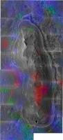
No, or not mainly so, because as you point out dust is too mobile. There wouldn't be a striking hole in the distribution inside the crater, a place that is clearly accessible to dust. The clay minerals must either themselves consist of larger fragments or coat larger fragments of something else, possibly shattered igneous material. Clay minerals as an external weathered layer on harder grains would fit with Bill's suggestion that the clays formed in cracks rather than being the main bulk constituent of a 'clay layer'.

This leads to the question of whether or not the clays formed before the Endeavour impact. Accepting PaulM's obsevation that the clays on Cape Tribulation seem to follow layers I would say this leaves at least two possibilities open. Either, as PaulM suggests, there were clay-rich layers in place before the impact or, perhaps, there were layers of some rock that had the propensity to form clay minerals in fractures produced by the impact, presumably in the continuing presence of moisture. If we are seeing clay signatures from external coatings on many gravel-sized fragments I think that could point to the latter.

It's a complicated place and too early to draw conclusions for sure, but not too early to be thinking about it. I just marvel and celebrate the fact that we are freely provided with so much information that we can do that. smile.gif
SFJCody
QUOTE
Sol Seq.Ver ETH ESF EDN EFF ERP Tot Description
----- -------- --- --- --- --- --- ---- -----------
02750 p1595.02 0 0 0 0 0 0 navcam_sun_images_for_msl_pri58


Gathering info for Curiosity?
djellison
They did that quite some time ago as well - checking how well the Navcam's can be used for sunfinding.

One result looked like this :
http://marsrovers.jpl.nasa.gov/gallery/all...GTP1926L0M1.JPG

another

http://marsrovers.jpl.nasa.gov/gallery/all...6AP1926L0M1.JPG


This is a "lo-fi" version of our main content. To view the full version with more information, formatting and images, please click here.
Invision Power Board © 2001-2024 Invision Power Services, Inc.