SFJCody
Aug 2 2009, 04:02 PM
QUOTE (centsworth_II @ Aug 2 2009, 02:39 PM)

what about the possibility that BI was buried, through deposition, in the rock (not ice) layers in which the berries later formed and berries were left on it just as they were left on the rest of the Meridiani surface as the layers eroded away?
Rather than BI being encased in the rock, couldn't it have been slowly buried by migrating ripples at a time when Meridiani had thicker drift deposits than are currently there today?
Fast-forward to today and the really fine-grained material has blown away leaving much smaller ripples (and Block Island) with a surface cover of blueberries.
Phil Stooke
Aug 2 2009, 04:53 PM
I think all of these mechanisms are possible. Deciding between them will be the hard part.
Phil
centsworth_II
Aug 2 2009, 05:22 PM
QUOTE (SFJCody @ Aug 2 2009, 11:02 AM)
Rather than BI being encased in the rock, couldn't it have been slowly buried by migrating ripples...
Who knows?

BI could have been covered by migrating ripples that moved on or covered by ripples that were in turn covered and eventually hardened into rock, later to be eroded away.
If BI is REALLY old, it may have lived through a combination of the possibilities being discussed here.
Ant103
Aug 2 2009, 08:41 PM
Maybe OT but I wanted to show you an inspiration that make me the scenery just arround BI. I love to incrust 3D letters in realistic way, like the
Panic Room intro sequence 
.
Thanks for the correction Nprev
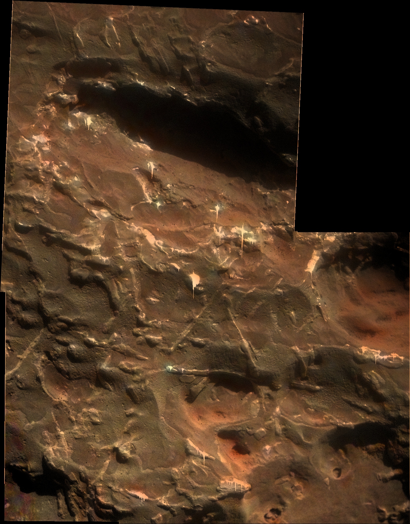
Another piece added to the MI mosaic...
Click to view attachment
Floyd
Aug 2 2009, 09:47 PM
Stu, Clearly triangleform writing of the Widmanstatten variety. Giger is a visionary.
Shaka
Aug 2 2009, 10:17 PM
QUOTE (MarsIsImportant @ Aug 1 2009, 10:25 PM)
If you are unfamiliar with the icy formation theory, then I am surprised. It was all over the news
(Three consecutive posts merged - ADMIN)
Ah, OK! You
were referring to the Niles-Michalski "icy test tubes model". I suspected as much, but had to allow that there might be some recent publication I hadn't seen yet that actually related blueberry formation with ice. Unlike the Niles-Michalski paper.
We did discuss this previously in the
"Meridiani Ice theory" thread. There Paul Niles himself assured us that their model did
not account for blueberry formation, but was concerned with the formation of the characteristic sulfate deposits of the Meridiani bedrock
prior to the diagenesis of concretions. Niles conceded that the MER team's original scenario of blueberries concreting at regularly-spaced intervals within the deposited sulfate sandstones (
after the icy phase) fit with the observations. That scenario does not predict concretions forming in closely-packed layers such as we see on Block Island. Such aggregations would only occur by advection of the blueberries after formation.
Ant103
Aug 2 2009, 10:30 PM
A colorized mosaic of the MI based on the top view of BI :
nprev
Aug 2 2009, 10:32 PM
Ant, VERY cool marker for BI; I'm sure that the MER Memorial Park Authority will emplace something just like that in a few hundred years...
One correction, and definitely not a criticism: The word is spelled "block", defined roughly as a solid, often massive piece of material in this context. "Bloc" is also an English word usually meaning a political or social coalition.
Again, no criticism implied; I know that English often sucks like this!
alan
Aug 2 2009, 11:20 PM
Any of the rockhounds have an explanation for the small gray patches? Are they due to the surface layer being worn off or are they due to variations in composition?
Click to view attachment
SteveM
Aug 3 2009, 01:32 AM
The criss-cross lines don't quite look like a Widmanstätten pattern. They have a less crystalline appearance and seem rounded and have something that looks like droplets near the ends.
Let me suggest two more possibilities:
* A Widmanstätten pattern was modified by melting during atmospheric entry.
* Widmanstätten patterns have nothing to do with it, and we're looking at flows of viscous melt during different phases of entry.
Steve M
serpens
Aug 3 2009, 01:46 AM
I initially though that this could be a Mesosiderite which would explain the deep cavities, but on reflection these cavities and the pronounced etching of the surface are most easily explained by initial burial of the meteorite and exposure to the acidic groundwater proposed by JPL. And there is an example of this process available.
http://en.wikipedia.org/wiki/Willamette_MeteoriteIn fact this meteorite could well be the definitive smoking gun supporting the JPL theory for Meridiani and finally putting the surge alternative to bed. (As I duck for cover I wish we had an emoticon with a crash helmet).
CosmicRocker
Aug 3 2009, 05:00 AM
QUOTE (serpens @ Aug 2 2009, 08:51 AM)
Yep, the simplest and most logical explanation.
I would whole-heartedly agree with that.
I'm not a meteorite expert, but regarding the possible Widmanstatten patterns, this would be the first time I've seen them exposed on a naturally weathered, meteorite surface. The geometry of these features seems right, but I would expect the patterns to be more repetitive, if you know what I mean.
I think I see what you're saying, serpens. Since we normally etch iron-nickel meteorites with acid to expose their Widmanstatten structure, the fact that this naturally weathered, Martian meteorite may be displaying such internal crystallinity on its surface suggests that it may have been exposed to an acidic environment in its past. Interesting.
Block Island was definitely worthy of the effort to go to back for a second look. I never dared to dream that I might, one day, be able to explore another world like this. What a ride this has been!
MarsIsImportant
Aug 3 2009, 06:07 AM
QUOTE (Shaka @ Aug 2 2009, 05:17 PM)
Ah, OK! You
were referring to the Niles-Michalski "icy test tubes model". I suspected as much, but had to allow that there might be some recent publication I hadn't seen yet that actually related blueberry formation with ice. Unlike the Niles-Michalski paper.
We did discuss this previously in the
"Meridiani Ice theory" thread. There Paul Niles himself assured us that their model did
not account for blueberry formation, but was concerned with the formation of the characteristic sulfate deposits of the Meridiani bedrock
prior to the diagenesis of concretions. Niles conceded that the MER team's original scenario of blueberries concreting at regularly-spaced intervals within the deposited sulfate sandstones (
after the icy phase) fit with the observations. That scenario does not predict concretions forming in closely-packed layers such as we see on Block Island. Such aggregations would only occur by advection of the blueberries after formation.
I understand the caution and doubt from a scientific perspective. But you have to start somewhere. You take a bit of speculation and develop it to come up with a hypothesis that can be tested. That's all I've done.
The blueberries need acid to form, but that wouldn't last long in this soil. That suggests a mechanism other than simply groundwater must have played a part. If SO2 from volcanism played a significant part in atmospheric warming instead of the normally accepted CO2, then interaction of dust and atmosphere to make the necessary acid on top of the glacial ice field is a possibility. In fact, its a high probability that this scenario is the correct one because of the sulfates found...yet no limestone deposits have been discovered anywhere on Mars.
Was there groundwater? Of course. If there was glacial melt and sublimation, then there must have been ground water too. But groundwater alone cannot explain all the variables found in the soil at Meridiani. Ice and atmospheric interaction provides a convenient method over an extended period of time to change the top layers of the soil from basic to acid and back to basic again.
The fact is that we don't know how the blueberries were formed. Figure out the real conditions present eons ago, and we might have a chance to figure out exactly how the blueberries developed.
serpens
Aug 3 2009, 07:19 AM
QUOTE (MarsIsImportant @ Aug 3 2009, 07:07 AM)
Ice and atmospheric interaction provides a convenient method over an extended period of time to change the top layers of the soil from basic to acid and back to basic again.
But a simpler explanation is a groundwater playa in a basaltic environment with a period of volcanism that created an acidic aquifer that overcame the natural buffering until the acidification influence diminished and the natural buffering took over again.
MarsIsImportant
Aug 3 2009, 07:40 AM
But the distribution of of the berries does not suggest this. In fact, multiple cycles of basic, acid, basic, acid, basic, acid, and basic are suggested because the berries are through all the layers. One prolonged period would have created berries similar to Earth examples...meaning a lot larger and a different distribution.
Why do people continue to fight the obvious? The martian climate has changed drastically in certain ways. A water table appearing and disappearing as you suggest is just another type of climate change, but no less dramatic. So if the climate changed in one way, why not in an alternative way that can explain things? All the ingredients were present. It is just a question of form.
Mars was warmer in the distant past. There was liquid water present at one time or another. Today liquid water cannot exist on the surface of Mars for long because of the thin atmosphere. Is it such a leap of logic that the once liquid water must have gone somewhere, like became frozen near the surface, before it eventually migrated through sublimation to the current poles? And we know for a fact that those poles were not always Mar's poles.
djellison
Aug 3 2009, 09:26 AM
If you want to have an argument about the history of Meridiani, can you start a new thread please.
edit : I see someone decided to ignore this request. Post deleted. Twice.
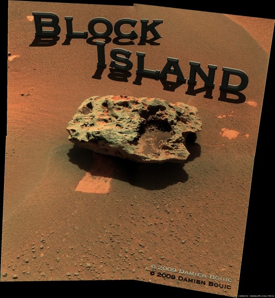
How big is Block Island? I make it
very roughly this size...
Click to view attachment
stevesliva
Aug 3 2009, 04:44 PM
What's the prevailing wind direction indicated by the smoothed edge of this rock? It's interesting that the dunes to the east seem to have a longer wavelength. Wake effect?
alan
Aug 3 2009, 05:49 PM
[quote name='Stu' post='144234' date='Aug 3 2009, 11:30 AM']How big is Block Island? I make it very roughly this size...
It looks like its being held over someones head. Block Island is a foot high and at least two feet across, probably weighs nearly half a ton. It would be more realistic to show someone crushed underneath it.
climber
Aug 3 2009, 08:45 PM
I thought "you" were not able to convert foot to metrics, I see now you're not even able to make a difference between hand and foot

QUOTE (alan @ Aug 3 2009, 06:49 PM)
It looks like its being held over someones head. Block Island is a foot high and at least two feet across, probably weighs nearly half a ton. It would be more realistic to show someone crushed underneath it.
Anyone else out there guess I wasn't going for "realism"? haha! The hand is simply there for scale!

MarsIsImportant
Aug 4 2009, 01:34 AM
QUOTE (Stu @ Aug 3 2009, 04:48 PM)
Anyone else out there guess I wasn't going for "realism"? haha! The hand is simply there for scale!
Well, I guess you could make it a 3D animation where BI is rotating on your index finger like a Harlem Globetrotter's basketball!


But I guess we need more data for realism. We need a peek at the underside of the rock 1st before we can create an accurate rendition.

Fran Ontanaya
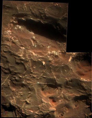
Aug 4 2009, 04:13 AM
Playing with an image registration tool and the last MI images.
Click to view attachment
Marz
Aug 4 2009, 03:13 PM
QUOTE (Fran Ontanaya @ Aug 3 2009, 10:13 PM)
Playing with an image registration tool and the last MI images.
Looks like a high percentage of metallic minerals reflecting so much light. Seems like these are fairly common on Mars. Are Iron-Nickel meteors more common on Mars because of proximity to the Asteroid Belt, or are meteors preserved due to lack of weathering and other geologic forces that allow them to concentrate on the surface much more than Earth?
Struggled to align this pair accurately, so apologies in advance for any migraines induced...
Click to view attachment
dvandorn
Aug 4 2009, 07:48 PM
QUOTE (Marz @ Aug 4 2009, 10:13 AM)
Are Iron-Nickel meteors more common on Mars because of proximity to the Asteroid Belt, or are meteors preserved due to lack of weathering and other geologic forces that allow them to concentrate on the surface much more than Earth?
Yes.
Seriously, both functions are probably at work, here. We really don't have the best handle on relative impact rates (as sorted by size and class of impactor) at Earth v. Mars, but it's a decent bet that there is a higher density of potential impactors as you approach the main Belt. And while it hasn't been proven yet, it also appears that this particular hunk of metal was buried for a long time and has since been re-exposed due to the aeolian deflation of the upper rock layers at Meridiani. That has a similar preservation effect that you see with meteorites that land in Antarctica, are buried in ice for very long periods, and are then thrust back to the surface via one or more of a variety of processes.
-the other Doug
Shaka
Aug 4 2009, 08:21 PM
Rather nice little
article on Block Island from New Scientist. Apparently the APXS has confirmed the iron-nickel ID.
Written by one Maggie McKee - indications that she reads UMSF, or do we know her by some other
nom de web?
One questionable item: she says Heat Shield rock has been renamed Meridiani Planum!? That's what it sits on, right?
PDP8E
Aug 4 2009, 08:50 PM
Shaka,
Meteorites are 'usually' named after the location they are found...locality name, followed by regional information -etc.
(its because geologist rock naming conventions were stretched to cover meteorites)
For example:
* Allan Hills (ALH) 88070 meteorite, Victoria Land, Antarctica
There is a link in the story that brings you here:
http://tin.er.usgs.gov/meteor/metbull.php?code=32789Cheers
Shaka
Aug 4 2009, 09:12 PM
Ah,
so desuka! Thanx, PD; I guess that means BI will also be named
Meridiani Planum, as well as any others Oppy finds?

So we have to tell them apart by the following number?
ZOUNDS! I think I'll stick with the unofficial names.
HughFromAlice
Aug 4 2009, 09:54 PM
QUOTE (Stu @ Aug 5 2009, 01:53 AM)
migraines induced...
Migraine :-( ? Moving my 3D (Dinosaur viewing!!!) glasses a few cms away from my face gave me pleasant unstrained viewing - really good depth :-) !
djellison
Aug 4 2009, 10:12 PM
So Heatshield Rock should be MP040001
marsophile
Aug 4 2009, 10:37 PM
QUOTE (PDP8E @ Aug 4 2009, 12:50 PM)
Meteorites are 'usually' named after the location they are found...locality name, followed by regional information -etc.
(its because geologist rock naming conventions were stretched to cover meteorites)
It makes sense to use that identifying nomenclature when the object has been removed from its place of discovery. It seems to make less sense when it has been left there (as is the case here) because of the greater potential for confusion.
PDP8E
Aug 5 2009, 01:02 AM
what i found interesting was the 'flag' in the bulletin near the end showing where it was found!
check it out:
http://tin.er.usgs.gov/meteor/metbull.php?code=32789I poked around and then I found this:
http://en.wikipedia.org/wiki/Flag_of_MarsI guess Emily sewed it on her lap by the flickering light of the fireplace over the winter....
*** EDIT: to all you confused emailer's, that was a Betsy Ross (USA flag designer) reference...
CosmicRocker
Aug 5 2009, 05:36 AM
QUOTE (dvandorn @ Aug 4 2009, 02:48 PM)
... but it's a decent bet that there is a higher density of potential impactors as you approach the main Belt. ...
That makes sense to me, Doug, but when comparing the theoretical impact rates of Earth and Mars, it seems that the trajectories of in-falling meteorites would tend to converge near the sun. Since Earth orbits closer to the center of the system than Mars, would one not expect a higher density of in-falling meteor trajectories to pass near Earth's orbit? Surely this has been modeled by someone.
nprev
Aug 5 2009, 06:04 AM
Don't forget our good friend Jupiter's influence on meteoroid flux. I suspect that the true situation is more complex than it appears.
Fran Ontanaya
Aug 5 2009, 09:17 AM
Aren't second chances more common in Mars? Earth may deflect more near misses.
Also, the early Earth-Moon system could have had a barycenter in open space.
centsworth_II
Aug 5 2009, 07:27 PM
From
Planetary Society MER Update (last sentence):
“Block Island is big enough,” Arvidson said, “and has the characteristics that might tell us something about more recent weathering history than we've been able to retrieve so far.”This may have been before they knew it was a metallic meteor. Weathering effects on Mars would be overlain on effects of the meteoric plunge through the atmosphere -- a challenge to interpret.
Or is the best information of recent weathering history gotten from the pedestal on which the meteorite sits? That pedestal is a remnant of a surface that no longer exists over the surrounding area.
QUOTE (alan @ Aug 1 2009, 08:51 PM)
...pedestal visible on the lower left...
Click to view attachmentQUOTE (CosmicRocker @ Aug 2 2009, 12:13 AM)
...regarding the pedestal, good catch, alan.... this most recently protected pedestal is not likely to have been the first pedestal this lagging boulder has perched upon.
The simplest scenario I can envision is a meteor crashes into Meridiani, burying itself beneath its crater. Then, over the years, the crater is worn away, revealing this meteorite. Over yet more years the surrounding plain is worn down, raising BI up on a pedestal. Perhaps, as CosmicRocker said, this is not the first such pedestal. Perhaps BI has fallen from previous pedestals as they were worn from beneath it, like walking down a flight of stairs.
While there has been net removal of material from Meridiani since BI's arrival, there may also have been periods of deposition. I wonder if it can be determined if BI arrived before, during, or after the period of blueberry formation.
MarsIsImportant
Aug 6 2009, 12:14 AM
Several people have mentioned a pedestal underneath this meteorite. Nor do I see one on any previous discovered meteorite. I've searched and don't see it. Alan mentioned the possibility of a previous pedestal but that area simply looks like possible chemical weathering to me.
I highly doubt that there would be aeolian produced pedestals on on any of these rocks. The atmosphere is far to thin to expect such a thing. If there really is a pedestal, then that would suggest major atmospheric change over the years. Perhaps it could have been produced by repeat 'surges', but I doubt that seriously (more likely to have simply covered the whole thing up).
Show me the pedestal because that would be a big discovery.
alan
Aug 6 2009, 04:41 AM
Take a closer look at the image quoted in centsworth_II 's post. The exposed bedrock, which is flat outside the shadow, turns nearly vertical a short distance into the shadow. Or look at the
anaglyph posted by Ant103
Edit: here is a brightened version of the anaglyph
Click to view attachment
James Sorenson
Aug 6 2009, 05:05 AM
If this is a pedestal, and the the likelihood of the meteorite being exhumed by the wind, would this confirm that this meteorite landed at this exact spot as a secondary? or carried by some other fluid process to this spot (i.e.Glacial ice), and sat here disturbing the local bedrock by just the weight, berried, then uncovered? If this meteorite was thrown to this spot as a secondary, could this pedestal (assuming that it us one) provide any sort of trajectory information (by looking how the bedrock is disturbed) about which direction it came from, possibly narrowing out out what crater it came from?
centsworth_II
Aug 6 2009, 05:07 AM
QUOTE (MarsIsImportant @ Aug 5 2009, 08:14 PM)
Show me the pedestal because that would be a big discovery.
Looking for the first time at images of BI, I thought there was a flat curve of exposed pavement leading up to the left side of the rock. When alan posted his image, I looked again and it did indeed seem that a pedestal curved
up and away from the surface.
Wishful thinking? Is it obvious to most out there that there is a pedestal (or not), or is it still an open question?
CosmicRocker
Aug 6 2009, 05:18 AM
QUOTE (centsworth_II @ Aug 5 2009, 02:27 PM)
... "has the characteristics that might tell us something about more recent weathering history than we've been able to retrieve so far.
I was guessing that they might be looking at the large, gaping pit on the right side of BI for recent weathering evidence, but you raise some good points, 2CentsWorth. I guess we'll have to watch to see where the IDD's instruments go.
QUOTE (MarsIsImportant @ Aug 5 2009, 07:14 PM)
Several people have mentioned a pedestal underneath this meteorite. ... I highly doubt that there would be aeolian produced pedestals on on any of these rocks. The atmosphere is far to thin to expect such a thing. ...
I thought it was apparent in the image alan posted, but it really would be best if it could be seen in a 3D image. I think some early morning and late evening hazcam imagery could help in that regard, but alan's brightened ant103 anaglyph does the job nicely.
How can you doubt recent aeolian erosional processes on Mars, MarsIsImportant? It is true that the atmosphere is thin, but several of us have posted time lapse imagery of sandy ripples advancing at rover locations during dust storms. Both rovers have captured images of multitudes of eroded rock faces that would be difficult to interpret as anything but eroded by the wind. Recall the eroded blueberries on stalks at Fram crater and other locations. Remember the wafer-thin beds perched in the air where Opportunity was stalled near the walls of Erebus?
centsworth_II
Aug 6 2009, 05:27 AM
QUOTE (James Sorenson @ Aug 6 2009, 01:05 AM)
....If this meteorite was thrown to this spot as a secondary...
I don't understand how BI could be a secondary. If secondaries are defined as fallout from an impact, then virtually all secondaries on Mars would be martian rocks, which BI is not.
If the meteor broke up in the atmosphere (do iron meteors break up?), all the pieces would still be primaries, no? If the meteor broke up on impact, the vector of all the pieces would still be down, wouldn't it? I don't see how a high speed impact would result in any part of the impactor reversing direction and shooting out of the crater. Admittedly, I am no expert on these matters.
centsworth_II
Aug 6 2009, 06:15 AM
Click to view attachmentI'm not so sure anymore. I don't know what the anaglyphs look like, but here the evidence for a pedestal is the sharp edge of the light rock to the right of the yellow line. It looks like the discontinuity between a pedestal's vertical face and loose surface material in the background. However, looking to the right of the orange line, it seems there is a continuous layer of loose surface material leading up to BI. Even if you imagine the light rock to the left of the orange line to be curving up as a pedestal, it is hard to imagine the loose material to the right of the orange line also curving up the face of a pedestal.
The rugged, cliff-like texture of the light rock under BI adds to the impression of a pedestal, but that is mostly due to the contrast and brightening adjustments needed to look into the shadow.
So the edge of the light rock along the yellow line looks like it could be a pedestal but the edge along the orange line does not. I'm starting to think the pedestal may just be wishful thinking after all.

James Sorenson
Aug 6 2009, 07:00 AM
The 3D images at least to me, show the bedrock material thrust upwards and supporting at least some weight of the meteorite (speculation), as if it impacted that way.
EDIT: Here is a better, High-contrast/brightend version of Ant's 3D image. Its without a doubt this is a "pedestal". The more I look at it, the more I see it as ether impact related or could also be weathered to. Note how the layers of the bedrock bends in conform with how the rock is thrust up. Hmmmm!!!
Click to view attachment
MarsIsImportant
Aug 6 2009, 11:17 AM
That's not a pedestal. It is the kind of broken pavement we have seen all over Meridiani. If there is a pedestal it has not been imaged yet.
Wishful thinking? Yes, thinking that was a pedestal was wishful thinking. It is an illusion.
As far as erosion is concerned...of course there is minor aeolian erosion happening on Mars. But that does not mean the forces are powerful enough to create a erosional pedestal. Most of the movement is picking up small grains and transporting them elsewhere. And when that happens the larger of the small grains generally only move a few inches.
djellison
Aug 6 2009, 01:04 PM
QUOTE (MarsIsImportant @ Aug 6 2009, 12:17 PM)
.of course there is minor aeolian erosion happening on Mars. But that does not mean the forces are powerful enough to create a erosional pedestal.
Just look at the aeolian sculptures around Home Plate. The Aeolian erosion may be 'minor' - but it has been happening, almost unimpeded, for billions of years. Do not underestimate its potential.
CryptoEngineer
Aug 6 2009, 02:46 PM
I'm trying to picture how such a pedestal could form.
(Warning - non-geologist talking here)
A pedestal exists because the capping object modifies things in a way that slows down erosion of the material underneath it. Most typically, on Earth, it protects against rain. That's not happening here.
But: If the entire surface is deflating due to aeolian erosion, you could still get a pedestal: if the iron meteor is much more resistant to erosion than the rock surface it is laying on, it protects the surface it is laying on from erosion from above. That protected rock can only be eroded from the side, as the deflation of the surrounding surface drops below the level the meteor is resting on. As the erosion works inwards, it leaves the meteor perched on the pedestal, until it becomes too thin, or the material under the meteor's center of gravity erodes, at which point it topples off and the process starts over.
Have I got it right?
It seems to me that if we really aren't sure if this is a pedestal or not, there's an easy way to find out: Spirit has been using its MI to get some notion as to what's going on underneath it. Oppy could use it to get a worms-eye view of the base of BI, and see if there is daylight around the edges of BI.
CE
marswiggle
Aug 6 2009, 03:34 PM
Throwing in a crosseyed image about the supposed pedestal, a crop of the L2 & R2 raw image pair. Not corrected or enhanced in any way. I'm seeing a raised edge at the left side of the outcrop, but as others said we need a better view before making any conclusions.
This is a "lo-fi" version of our main content. To view the full version with more information, formatting and images, please
click here.