The Navcam L0 view on Sol 4709-4710.
Jan van Driel
Click to view attachment
Full Version: Beyond Lewis and Clark Gap
i might be wrong but assume this sol4711 image of the downslope corresponds to the top of our entry point. some other nice views of late from sol4712 and sol4713 in anaglyph and trimmed crosseye form..
Click to view attachment Click to view attachment Click to view attachment Click to view attachment Click to view attachment Click to view attachment
Click to view attachment Click to view attachment Click to view attachment Click to view attachment Click to view attachment Click to view attachment
Just to clarify is Opportunity on way to those Gully like features?
Yes, Perseverance Valley is tbe gully like feature that Oppy is going to. Very close now.
Here is Jan's new panorama in circular form. We are right beside the little crater Orion. The even smaller crater (pit) Mariner 4 is just to the SW of the rover.
Phil
Click to view attachment
Phil
Click to view attachment
... and a circular version of it. Thanks! That small crater just north of us is visible in HiRISE. (EDIT - it's called Casper. Orion and Casper were the Apollo 16 LM and CSM respectively.) One more drive and we'll be on the rim. Maybe two drives to allow for some careful positioning right on the edge.
Phil
Click to view attachment
Phil
Click to view attachment
..and the anaglyph view
Click to view attachment
Click to view attachment
Phobos transit visible in these 4719 pancams, even though the public jpegs are clipped:
Click to view attachment
Click to view attachment
Think we really need to visit that slab. it could be exposed Carbon ice.Gypsum..or whatever.. it seems rigid in place and not eroding on par with the crater and it seems linked on the Hirise Image to an interesting surface feature that may even be related to the gully
Its brightness is very noticeable.


What do you guys think? I can't recall seeing a feature like this on that scale
Its brightness is very noticeable.
What do you guys think? I can't recall seeing a feature like this on that scale
QUOTE (jvandriel @ May 5 2017, 10:49 AM) 
and the Navcam L0 view on Sol 4720. Jan van Driel
Thank you very much Jan van Driel

Can those ripples in front of the rover be considered as "sand traps" ?
"I can't recall seeing a feature like this on that scale"
Look back 1000 sols to the images on this page:
http://www.midnightplanets.com/web/MERB/sol/03749.html
(Wdowiak Ridge, sol 3749)
The geologists who run the mission have not noted this as anything especially unusual. I personally think it's just the same as lots of other lumps and bumps seen along the crater rim. There are much more compelling reasons to go down into the crater again, where broad areas of outcrop downhill from the 'gully' will be explored later.
This is Jan's half-panorama from sol 4720 in a circular projection. It makes the slopes look much steeper than they really are. I would anticipate a drive out onto that spur just to the north of us (top of the image) to get a better look across the slope and into the valley.
Phil
Click to view attachment
Phil
Click to view attachment
QUOTE (Steve5304 @ May 5 2017, 03:01 PM)
Think we really need to visit that slab. it could be exposed Carbon ice.Gypsum..or whatever...
Its brightness is very noticeable.
Its brightness is very noticeable.
From the latest PS report:
QUOTE
It was intriguing enough for the scientists to consider dispatching Opportunity for a quick visit. It would be their only chance since once the rover descends into Perseverance Valley, she wont be coming back this way again. Our estimate was that it would take a month to go to Winnemucca, look at it, kick around, and get back, said Golombek.
Ultimately, the decision was no go
Ultimately, the decision was no go
And ice would be much brighter than this - remember that Mars soil is usually very dark. Check out some of those old Phoenix ice pics.
It's unlikely to be ice now, but there may have been ice there sometime in the past. Note the potential remnant of a melt area to the west of the feature.
My very first post.
I am wondering. Why there is no talk of going upstream, west, of Perseverance Valley, for a bit.
If I were there, I'd check out that wash - upper stream bed source first very carefully, before committing myself to going over a thousand foot edge.
From what I can tell by the most basic Google Mars, the upper stream bed starts at a very small crater no more than a couple 100m west of the edge.
Add that new crater towards SW, and those bright white ring craters further on. A football field away or two all of them.
.
It just seems like there is not going to be an inspection of the headwaters, before going over the falls.
Been here every day, since 2009. Just now speaking up. This is the best website ever!
. . . . . . . Caso
Opportunity has accumulated a decades worth of wavelength / albedo correlations encompassing sedimentary deposits, dust and Endeavour's Noachian deposits. I suspect that they have a pretty good idea as to the composition of the Winnemucca bright area. Given the environment we can be certain that it is not CO2 or water ice.
My very first post.
I am wondering. Why there is no talk of going upstream, west, of Perseverance Valley, for a bit.
If I were there, I'd check out that wash - upper stream bed source, first very carefully, before committing myself to going over a thousand foot edge.
From what I can tell by the most basic Google Mars, the upper stream bed starts at a very small crater no more than a couple 100m west of the edge.
Add that new crater towards SW, and those bright white ring craters further on. A couple football field away or three all of them.
.
It just seems like there is not going to be an inspection of the headwaters, before going over the falls.
Been here every day, since 2009. Just now speaking up. This is the best website ever!
. . . . . . . Caso
The TPS report also says this:
So we can at least hope for some additional remote data on this interesting feature.
QUOTE
Nicknamed Winnemucca, the MER scientists considered sending the rover to check it out. But Perseverance Valley is the objective and winter is coming. Instead, the scientists are examining Winnemucca with ground imagery, remote sensing, and an orbital mineralogical detector.
So we can at least hope for some additional remote data on this interesting feature.
More Phobos transits on 4720 and 4721. These are easier to see in the public jpegs because there's a dimmer internal reflection of the sun that isn't clipped:
Click to view attachment
Click to view attachment
Click to view attachment
Click to view attachment
"My very first post.
I am wondering. Why there is no talk of going upstream, west, of Perseverance Valley, for a bit. "
Hi David - the little valley is thought to be very old, certainly if it was formed by water. So the real headwaters, if there were any on the surface, would have been buried by the 'Burns Formation' sandstones (as we saw in Victoria crater and all through those plains), and if not then certainly buried under the modern sand dunes (tsk - I mean ripples) which we see all over the plains west of the current position. And there might not have been headwaters as such anyway, the water could have flowed out of an aquifer where the crater wall cut through it, or it could have been fed by melting snow. So, probably nothing to see. Anyway, it seems they are eager to get into the valley after doing some stereo mapping.
Phil
Jan's full panorama in circular form. Those linear rows of little stones are intriguing.
Phil
Click to view attachment
Phil
Click to view attachment
QUOTE (jvandriel @ May 6 2017, 11:03 AM)
The Navcam L0 view on Sol 4720-4721.
Click to view attachment
Click to view attachment
These images are from my first solo shift as ECam Uplink lead on Opportunity. Sequences p1961, p1962 and p1963 were lovingly hand crafted.....I even dropped the center 3 frames a few degrees from the usual drive direction 5x1 pointing to get a little more valley in there.
I can't even begin to put into words how it feels to go from founding this place 13 years ago, to working at JPL 7 years ago, to starting ECAM on MSL last year, and now on Opportunity this weeks.
It's one hell of a journey, in many many ways

Indeed it has been. Superb work, Doug.
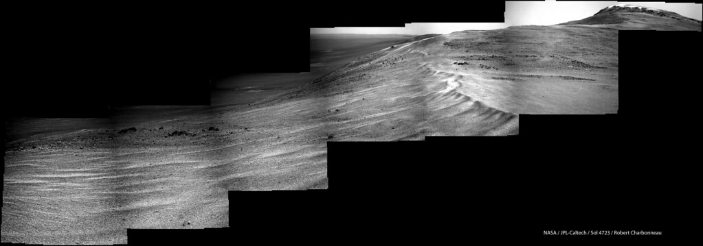
Sol 4723 Lpancam view:
MER Sol 4730 NL

Quick & dirty hand stitch with extended sky and some wobbly exposure seam repair.
Quick & dirty hand stitch with extended sky and some wobbly exposure seam repair.
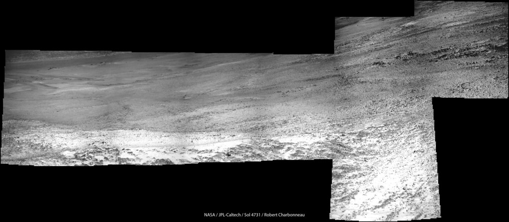
Sol 4731 Lpancam:
The channel being ancient as it is would have accumulated a lot of dust and therefore I presume that the rover is going to have a difficult time to reach any minerals which would have been deposited by the water which formed the channel.
Hmm, I wonder if they are going to ask to drag our feet while down the ramp? Sort of a Spirit driving technique?
Paolo
Paolo
dragging the wheel sounds like a great idea, subsurface deposits hiding just under our feet..
Below is an attempted match-up (i may be way off) of features from Phil's map and Charborob's pano those great works I recycled here rather than afflict the mess i stitched. The inset crosseye details a signifficant trough in the gully (green line)..
It would be interesting to have an idea as to how much original material has been eroded from the rim, as my recurring (and absolutely amateur) impression of the gully is it is more of a remnant of some fairly recent and short-lived Milankovitch cycle snowpack (catastrophic melt?) type of feature rather than a Hesperian era surface or hydrothermal emplaced creek.
Click to view attachment
An eposter that provides an easy read summary of Endeavour including assessed erosion levels is here: https://www.hou.usra.edu/meetings/lpsc2015/eposter/2017.pdf
The spherule lag deposits on the plains imply that there has been only a few metres of erosion of the fragile sedimentary deposits since the Meridiani water table dropped around 3.5My, so preservation of remnants of an early gully seems quite reasonable following desiccation of the environment. Prior to that with a near surface water table at Victoria crater and the permeable sedimentary deposits there must have been a plentiful water supply at Endeavour.
The spherule lag deposits on the plains imply that there has been only a few metres of erosion of the fragile sedimentary deposits since the Meridiani water table dropped around 3.5My, so preservation of remnants of an early gully seems quite reasonable following desiccation of the environment. Prior to that with a near surface water table at Victoria crater and the permeable sedimentary deposits there must have been a plentiful water supply at Endeavour.
Evidence of a DD or gust between sols 4730 and 4733 - note the new dark streak:
Click to view attachment
Click to view attachment
Here is a little bump for my VR ready Sketchfab models covering Oppy's location.
Click thru each image to see...
Marathon Valley, Endeavour Crater

Beyond Lewis & Clark Gap

I've updated VR starting location in each as well as improved clipping planes.
Click thru each image to see...
Marathon Valley, Endeavour Crater
Beyond Lewis & Clark Gap
I've updated VR starting location in each as well as improved clipping planes.
Click to view attachment
Parallel-eye stereo of part of the Winnemucca mesa.
Note the apparent hanging formations.
Parallel-eye stereo of part of the Winnemucca mesa.
Note the apparent hanging formations.
QUOTE (Sean @ May 18 2017, 06:42 PM)
Here is a little bump for my VR ready Sketchfab models covering Oppy's location......
Beautiful work Sean and much appreciated.
If the valley is as it seems a remnant water feature then the erosion resistant ridge below where it terminates (covered by regolith?) and the exposed polyhydrated sulphates rich area below that could hold a few surprises.
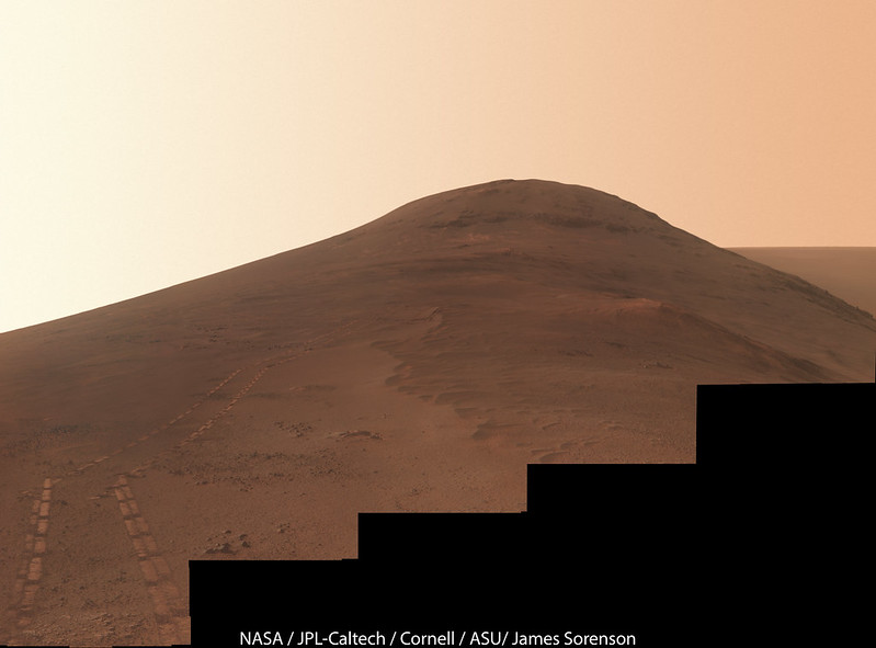
Gorgeous view back towards Cape Tribulation on Sol 4743! My attempt at an approximate true color version of this mosaic.
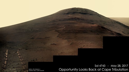
My take.
This is a "lo-fi" version of our main content. To view the full version with more information, formatting and images, please click here.