Full Version: Cape York - Northern Havens
That postcard and panorama is so very cool that it's pulled me out of lurking. Very good job indeed!!! Thanks!!!
Very nice Ant103! 
It's like being there!
It's like being there!
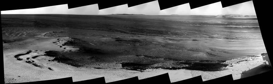
Gorgeous work, Ant! How many degrees is the Greely Pan? Full 360?
Thank you very much
@brellis : yep, that's a full 360 .
.
@brellis : yep, that's a full 360
.
indeed! thanks Ant and all. Drooling in anticipation of a pano with those last few gaps filled :^)..............
QUOTE (Ant103 @ Jan 27 2012, 04:51 PM) 
Hi everyone, And best whishes for this 2012 year .
.Thanks a lot Fourmi 103 and have a nice & happy year 2012 also.
GREEAT work !

In my opinion it is not a full 360 degree circle.
A full 360 contains a row of 27 images and I count 26 images.
The colum with horizon image 1P379153749EFFBR43P244L257 is the one which is missing.
For the rest great pano.
And I wish you all the best with the rest because another row
of images is coming down.
Jan van Driel
A full 360 contains a row of 27 images and I count 26 images.
The colum with horizon image 1P379153749EFFBR43P244L257 is the one which is missing.
For the rest great pano.
And I wish you all the best with the rest because another row
of images is coming down.
Jan van Driel
QUOTE
In my opinion it is not a full 360 degree circle.
A full 360 contains a row of 27 images and I count 26 images.
A full 360 contains a row of 27 images and I count 26 images.
Huh, what ?

So, how do you explain that the panoramic is looping itself ? Or maybe the law of space have changed or something ? But seriously, what can I do with "that" ?
Yes, I've seen that some pictures are coming to add a third line at the bottom. I will work on this
.@Olivier : Merci beaucoup
.
QUOTE (Ant103 @ Jan 28 2012, 06:41 AM)
But seriously, what can I do with "that" ?
Ant: jvandriel is correct. You're missing the images from sol 2843. (You probably want the ones from sol 2843, not 2827 - the earlier ones are from a separate mosaic of Morris Hill, not the Greeley pan. They overlap.)
Very nice 345º panorama though.
Okay ! I understand better now.
Looks like I was trolled by Hugin
Click to view attachment
Look at the bottom slider, and how both end are emerging.
Damn Hugin
Looks like I was trolled by Hugin
Click to view attachment
Look at the bottom slider, and how both end are emerging.
Damn Hugin
Ant103
that is better.
Further I have great respect for you and the other stitchers who stitch
together the best estimated real colour panoramas.
I can not do that.
Jan van Driel
that is better.
Further I have great respect for you and the other stitchers who stitch
together the best estimated real colour panoramas.
I can not do that.
Jan van Driel
I too applaud you dedicated souls for producing this Greeley Masterpiece, fitting of Oppy's renaissance ...
I've only just started working on my version of the Greeley Pan, but to join the party I thought I'd share an initial low res image straight from my automated process before I've done any fiddling.
James
James
Beautiful pans, guys!
Navcam caught some clouds drifting by on 2847 - these should be more common as we approach winter:
Click to view attachment
Navcam caught some clouds drifting by on 2847 - these should be more common as we approach winter:
Click to view attachment
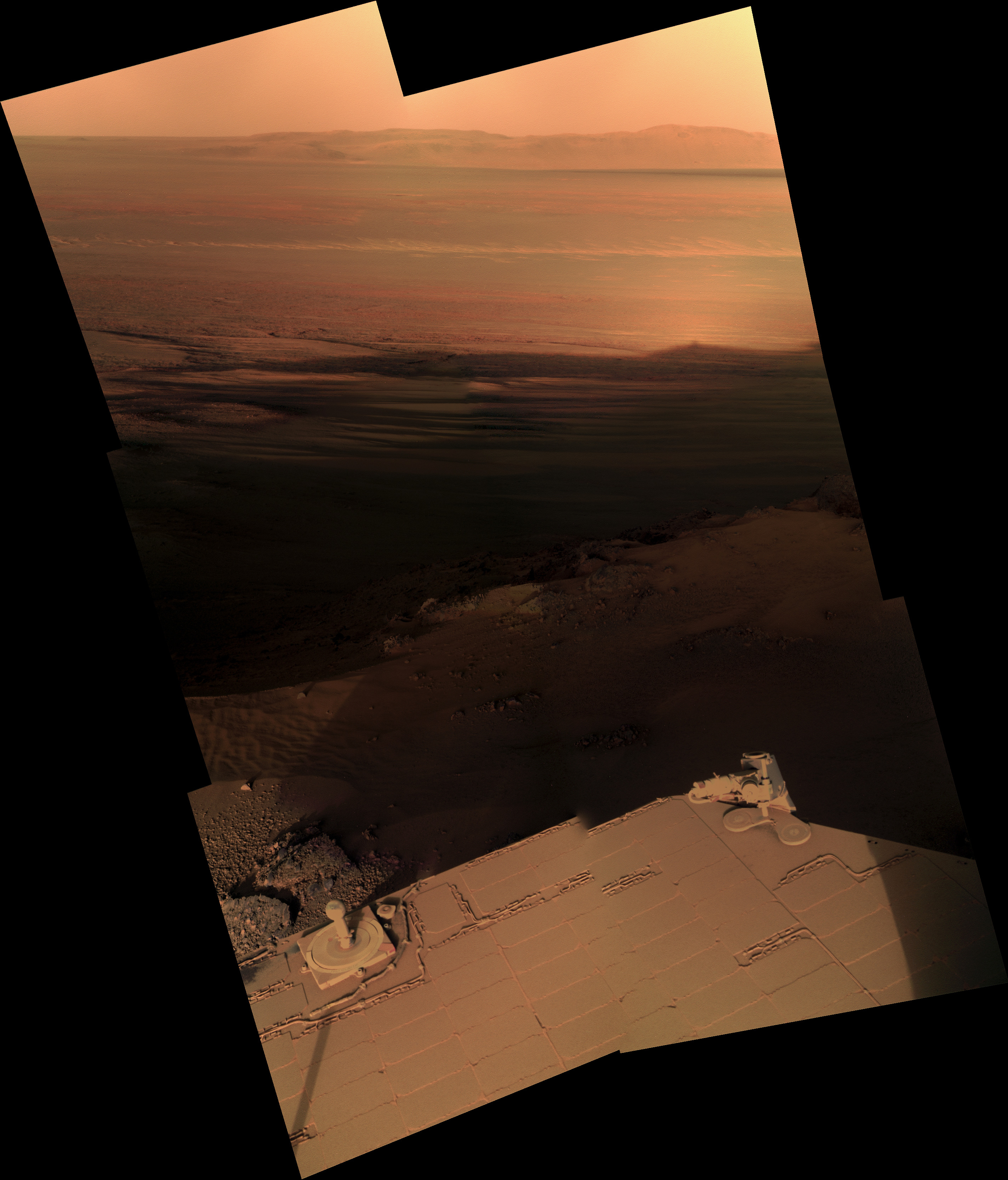
Low sun pano of the late afternoon, Sol 2840.
Pano too big to post the direct link, so redirection to various resolutions.
Nice catch Fred !
Pano too big to post the direct link, so redirection to various resolutions.
Nice catch Fred !
More late afternoon frames coming down. In this one, we might be seeing the shadow of Oppy, or perhaps the outcrop she's on, arrowed here:
Click to view attachment
What suggests this to me is that, if you look closely, you can see what seems to be an "opposition surge" or "Heiligenschein" centred around what could be Oppy. I'd need to check the geometry to be sure.
Click to view attachment
What suggests this to me is that, if you look closely, you can see what seems to be an "opposition surge" or "Heiligenschein" centred around what could be Oppy. I'd need to check the geometry to be sure.
Great minds think alike, Fred (not suggesting I am a great mind, it's just a saying, you know...)
Just been working on a colour version of that, and yep, I think that's Oppy... what an amazing image...
Click to view attachment
Just been working on a colour version of that, and yep, I think that's Oppy... what an amazing image...
Click to view attachment
Good grief - just when I thought it was safe to turn the machine off and go to bed . .
That's a classic. One for the headlines and the history books.
Well taken rover team and well spotted gentlemen.
That's a classic. One for the headlines and the history books.
Well taken rover team and well spotted gentlemen.
QUOTE (fredk @ Jan 29 2012, 07:27 AM)
Navcam caught some clouds drifting by on 2847 - these should be more common as we approach winter:
Click to view attachment
Click to view attachment
Wonderful! By the way, in upper right of the sequence one of Mars' moon is tracking across the sky. Or a star?
QUOTE (fredk @ Jan 29 2012, 03:44 PM)
I'd need to check the geometry to be sure.
Eyeballing it in MMB, the shadow is at 114 degrees from north, and the sun is going down around -66 degrees from north. That adds up to 180º...
Cool.
I'm sure others will do better, but here's my version.
Thanks for checking that! Very cool indeed. And I can't wait for the full mosaics with Oppy's deck in the foreground...
Edit: done before I finished my post! You can see that the shadow lines in the foreground converge to Oppy's distant shadow - just beautiful!
Edit: done before I finished my post! You can see that the shadow lines in the foreground converge to Oppy's distant shadow - just beautiful!
QUOTE (walfy @ Jan 29 2012, 10:57 PM)
in upper right of the sequence one of Mars' moon is tracking across the sky. Or a star?
Good catch! Those shots were taken about half an hour before sunset, so it can't be a star or planet. I'd be surprized if Phobos would be that obvious in a downsampled navcam through clouds and in daylight. And it would be extremely lucky to catch a glint of sunlight off a satellite. Can anyone check the azimuth of those navcams? That could rule out Phobos.
I kind of like this Instagram-med version for dramatic effect.
... one more from the sunset campaign on SOL 2847...
L257 always makes the 'blue target' pink! (any fixes out there?)
Click to view attachment
fred: I think that shadow down range is the sundial, the mast shadow is just coming into view on the far right.
EDIT
or the 'unfolding cleat' to the RIGHT of the sundial
(the shadow is the back deck with right of sundial 'cleat' at the apex)
Click to view attachment
EDIT
thanks Doug (for the next post)
QUOTE (PDP8E @ Jan 29 2012, 04:52 PM)
... one more from the sunset campaign on SOL 2847...
L257 always makes the 'blue target' pink! (any fixes out there?)
L257 always makes the 'blue target' pink! (any fixes out there?)
Yeah - go up there and replace the blue pigment with one that isn't massively nIR bright. That blue pigment is much much brighter in L2 than it is in L6 or 7.
L257 is almost nIR, G, B. Not RGB
Page 23 of http://marswatch.tn.cornell.edu/Bell_Pancam_JGR.pdf
.
QUOTE (fredk @ Jan 29 2012, 01:44 PM)
More late afternoon frames coming down. In this one, we might be seeing the shadow of Oppy, or perhaps the outcrop she's on, arrowed here:
Click to view attachment
What suggests this to me is that, if you look closely, you can see what seems to be an "opposition surge" or "Heiligenschein" centred around what could be Oppy. I'd need to check the geometry to be sure.
Click to view attachment
What suggests this to me is that, if you look closely, you can see what seems to be an "opposition surge" or "Heiligenschein" centred around what could be Oppy. I'd need to check the geometry to be sure.
Wow!
I'll ask the folks tomorrow if that could possibly be our shadow. Do you know what sequence ID(s) this image got captured with? This will narrow it down for me.
-m
edit
QUOTE (jamescanvin @ Jan 28 2012, 01:32 PM)
I've only just started working on my version of the Greeley Pan, but to join the party I thought I'd share an initial low res image straight from my automated process before I've done any fiddling.
James
James
See the HGA? It's moved! I wonder how the Pancam folks will stitch that out...
-m
QUOTE (Matt Lenda @ Jan 29 2012, 06:09 PM)
Do you know what sequence ID(s) this image got captured with? This will narrow it down for me.
P2445
I've got a lunch in the 167 cafeteria that says it's our shadow

QUOTE (walfy @ Jan 29 2012, 10:57 PM)
Wonderful! By the way, in upper right of the sequence one of Mars' moon is tracking across the sky. Or a star?
That's Phobos. It is anti-Sun-ish (E). A star would be rising, Phobos is setting. It has no right to be visible in the image, but there you go.
Edit: The image azimuth is 66; Phobos is at 86-87. The elevation is about 52 (sinking by 3/4 deg/minute).
Umm, yes, seems to be the right shadow. Using the automated image navigation, the anti-solar point is just below and to the left of the notch. The elevation is off (tilt uncertainty), but I referenced my guess of the horizon.
QUOTE (PDP8E @ Jan 30 2012, 12:52 AM)
fred: I think that shadow down range is the sundial, the mast shadow is just coming into view on the far right.
That shadow is so far away into Endeavour that we'd never be able to resolve anything on Oppy. At best she'd be a blurry speck. At worst the blurry speck is the whole outcrop she's on.
Thanks a lot for the info, Deimos. Remarkable to sight Phobos like this. I guess being anti-Sun helps - Phobos would be close to "full". Can anyone estimate a magnitude for a full Phobos as seen from the surface of Mars? I wonder if a search of old navcams would reveal any other sightings.
Just to clarify, the bump is either Opportunity or the outcrop that was identified (circled) in the image.
The rest of the shadow is part of the ridge of Cape York marked in yellow.
Click to view attachment
Can any of our image experts give a best guess for the distance of that shadow?
FredK - any chance of some 'waving men' put in place for scale?
The rest of the shadow is part of the ridge of Cape York marked in yellow.
Click to view attachment
Can any of our image experts give a best guess for the distance of that shadow?
FredK - any chance of some 'waving men' put in place for scale?
Very nice pictures you guys!
Here is my preview version of the Greeley Panorama sofar. I still have some color correction to do in between some images, plus there was some stitching error's that I need to address, but figured I'd show you what I got.
Click to view attachment
Here is my preview version of the Greeley Panorama sofar. I still have some color correction to do in between some images, plus there was some stitching error's that I need to address, but figured I'd show you what I got.
Click to view attachment
Fantastic James !
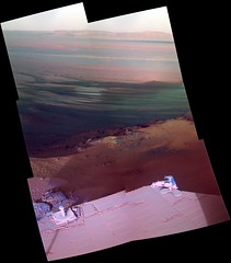
My version of the "shadow pan" of Sol 2846 :

My version of the "shadow pan" of Sol 2846 :
Starry Night gives Mv=-8.5. It appears to account for distance and phase.
Geometrically, Deimos should be in close to 1/8 of the p1587s, although at the edge. Phobos should be in a smaller number, maybe 5-10%. It could be in other sequences that have the sky near 85-90 and 270-275 azimuth. It would not be recognized without either the movie or stereo. It won't be in the stereo ones, as they are small swaths of sky near the horizon, through much more dust. We've deliberately had Phobos in Navcam before, at low elevations and moderate tau, without being able to see it (with no downsampling). Most of the time, p1587s are run with a much higher Sun (11 AM - noon); this time of day was opportunistic (no pun intended)--and the presence of Phobos was of course serendipitous.
Geometrically, Deimos should be in close to 1/8 of the p1587s, although at the edge. Phobos should be in a smaller number, maybe 5-10%. It could be in other sequences that have the sky near 85-90 and 270-275 azimuth. It would not be recognized without either the movie or stereo. It won't be in the stereo ones, as they are small swaths of sky near the horizon, through much more dust. We've deliberately had Phobos in Navcam before, at low elevations and moderate tau, without being able to see it (with no downsampling). Most of the time, p1587s are run with a much higher Sun (11 AM - noon); this time of day was opportunistic (no pun intended)--and the presence of Phobos was of course serendipitous.
QUOTE (Deimos @ Jan 29 2012, 08:56 PM)
That's Phobos. It is anti-Sun-ish (E). A star would be rising, Phobos is setting. It has no right to be visible in the image, but there you go.
Edit The image azimuth is 66; Phobos is at 86-87. The elevation is about 52 (sinking by 3/4 deg/minute).
Edit The image azimuth is 66; Phobos is at 86-87. The elevation is about 52 (sinking by 3/4 deg/minute).
Um, if Phobos is the dot in the upper right corner that appears in all four frames, what's the dot in the last two frames that tracks in a horizontal line just above the midline of the photo? In the third frame it is two-thirds of the picture over from the left edge, in the last frame is about one-sixth of the way from the left edge. What's the time between these two shots? Is this a deliberate attempt to photograph an overhead pass of one of the orbiters from Earth, possibly one used as a comm relay? Or OMG - maybe Mariner 9 or Viking 1 or 2?
Those two specks look like garden-variety cosmic ray hits. They don't have the clean "point spread functiony" look of Phobos. Remember that you can connect a line between any two points. When you get 4 in a line, with the right spacing between them, like with Phobos, then you know you've got something.
Nah- consider the size of Phobos relative to the size of any of our spacecraft. The spacecraft might be closer, but not enough closer to compensate for Phobos being 20 km diameter and the spacecraft being a few meters across.
John
John
"My version of the "shadow pan" of Sol 2846 :"
Holy cow! One of the most stunning MER images I've seen in ages
Holy cow! One of the most stunning MER images I've seen in ages
QUOTE (fredk @ Jan 30 2012, 09:49 AM)
Those two specks look like garden-variety cosmic ray hits. They don't have the clean "point spread functiony" look of Phobos. Remember that you can connect a line between any two points. When you get 4 in a line, with the right spacing between them, like with Phobos, then you know you've got something.
I still wonder if I've got something here.
Consider what is being said about this sequence of four cloud images which have six dots of light in them, four of which are identified as Phobos. Each frame of the four frame sequence is 512 by 512 pixels in size. Denote the lower left pixel as being at X=1, y=1 to define a standard Cartesian coordinate plane. Shooting the sequence at an azimuth of 66 degrees implies that the 66 degree heading is aligned along the vertical column of pixels in column 256. Look at the four dots of light visible in the upper right corner of the sequence. This is said to be Phobos descending nearly vertically in pixel column 448 at an azimuth or heading of 87 degrees. Thats a heading difference of 87-66=21 degrees in 448-256= 192 pixels for a scaling factor of around 0.109 degrees per pixel. Between frames 3 and 4 Phobos moves down about 14 pixels which would correspond to 14 * 0.109 = 1.5 degrees in the sky. If Phobos is sinking at 3 / 4 or 0.75 degrees per minute as specified in the forum discussion then these last two frames in the cloud sequence were taken two minutes apart.
Now look at the two mystery dots that appear to be flying from right to left in frames 3 and 4. Assume for a moment they are two images of the same object instead of two random cosmic ray pixel glitches. Note that if Phobos is descending anti-sunward in the east in the images, then the right-to-left motion of our mystery object means it is moving from south to north, over the poles a reasonable path of motion for a science orbiter from Earth like, say, Mars Odyssey with its inclination of 93.2 degrees.
Also, the mystery object changes its position by around 230 pixel units or 25 degrees in the field of view using the scaling factor defined above, and it does so in the two minute interval between frames. Horizon-to-horizon is 180 degrees, so at constant speed this mystery object would have appeared to go from horizon to horizon in (180/25)*2 = 14.4 minutes.
Huh, Mars Odyssey is used for 15 minute communication passes with the MER landers. See Step 18 at this NASA website:
http://marsrover.nasa.gov/mission/tl_entry1.html
So if the two mystery dots in this image sequence ARE cosmic ray glitches, they are glitches that ACCIDENTALLY mimic BOTH the expected direction AND expected speed of an orbital communications satellite that we know is being used by the rover.
Another point: are there statistics showing that two cosmic ray pixel glitches of this magnitude per every four images is routine? If not, then these are REALLY amazingly coincidental cosmic rays.
As for the it would never be visible argument, remember that Mars Odyssey or a Mars polar orbiter like her have got something Phobos doesnt solar cells that can reflect solar glint. Thats why we can see the Space Station from Earth on the ground as a bright star (usually right at sunset when the observer is in just entering darkness and the station is in still sunlight) as well as the infamous Iridium flares that can make a satellite in earth orbit appear as an incredibly bright -8 magnitude object in the sky.
http://en.wikipedia.org/wiki/Satellite_flare
So I still wonder - are the two mystery dots an orbiter from Earth?
the NAV cloud shots were taken at:
17:23:57
17:25:01 +64secs
17:26:21 +80secs
17:27:48 +86secs
17:23:57
17:25:01 +64secs
17:26:21 +80secs
17:27:48 +86secs
The points are not MGS, ODY, or MRO: these couldn't have been that direction, then. I think you can rule out Mariner 9, Mars 2,3,5, Viking 1 and Phobos 2: the inclination is wrong, but there may be a special alignment to get them to move that way. Most of those are too slow (except VO-1 near perigee). VO-2, if near perigee, could do that speed. It would be hard to show it really could have been there, then. Mars Express also might have been able to do something like that, but only near perigee (peri-ares, whatever). That'd be easier to check. So, if you wanted to follow this up, those two are the ones I'd suggest focusing on (especially MEX, since there exists someone who knows the answer to that).
That said: the second dot is a point source. The first is elongated in a direction other than aimed at the second (i.e., wrong for a motion streak). Both look just like many cosmic rays, and not like real objects.
The previous day, a similar sequence was run (pan rather than movie, but same exposure and downsampling). I see 1 obvious CR. Based on that and experience, 2 CRs in 4 images would not be unusual (these are short images, so I'm not comparing them to Pancam L7s). Given an image with a CR, figure there is a 10-40% chance the next image has a CR and you end up chasing spacecraft. On the other hand, there's a much lower chance one of the spacecraft has perigee in the right direction, times a small chance it is near perigee, times a small chance that it is going the right way.
So, no, it does not show an orbiter.
QUOTE (Deimos @ Jan 30 2012, 04:31 PM)
So, no, it does not show an orbiter.
Thanks for checking.
Here is a zoom GIF of Phobos in the NAVcam 2847 cloud sequence (in all its jpeggy glory)
Click to view attachment
Click to view attachment
Interesting pillar of a rock downslope. It looks paper-thin, only its shadow visible!
Click to view attachment
Click to view attachment
Was playing around with Content Aware Fill in PS CS5 for something for work this morning. Thought I'd give Ant's Shadow Pan a treatment. Not bad right off, just needed a few tweaks... (and yes I know it has "reconfigured" Oppy's solar panels but I figured she could use a few more for the winter
QUOTE (JayB @ Feb 1 2012, 02:13 PM)
Was playing around with Content Aware Fill in PS CS5 for something for work this morning.
Anyone know of how to do something similar in GIMP? I tried for awhile to remove a thumb from blue sky at the corner of one photo, and the suggested plugin just didn't cut it, even after a fair amount of experimentation. I handed a camera to a thumb-imparied guy, and had a series of photos I was hoping to tweak. I was discouraged from thinking the GIMP version could handle them.
My apologies if I have missed existing discussion regarding my impending question. I've looked and found nothing.
I've been watching tau at http://www.lpl.arizona.edu/~lemmon/mars-tau-b.html as I'm sure many here are, and have been surprised by the higher than typical tau for a given Ls since roughly sol 2630. I wouldn't think that the tau would vary locally enough at Endeavour to have this long and sustained of a delta. That leaves me at least with assuming that the variance from the past several years is at least regional. If so this thinking is sound, any thoughts as to what might be influencing the higher than typical taus this year?
-- Pertinax
I've noticed that too. One thing to keep in mind is that it can be hard to distinguish dust in the sky from dust on the pancam window and on the solar panels. That needs to be calibrated based on modelling (I think), and that calibration can be off. Check out this post for an example of that. So maybe unaccounted-for dust on pancam is making tau look higher than it really is. Or, of course, it may really just be a hazy winter.
This makes me wonder - since (I believe) there's no way to directly measure the amount of dust on the pancam window, and so the tau measurements are dependent on how well you model that dust, does the team provide uncertainties from those models? In other words, if tau is reported as around 0.7 now, but the modelling uncertainties give 0.7 +/- 0.3, then that tau value would actually be consistent with the previous Martian years. On the other hand, those previous years look entirely consistent with each other, so maybe the modelling uncertainties are small.
Another thing that's unclear to me is is the dust modelling accounted for each sol, or are corrections only made periodically?
I'll try a "brief" clarification about the opacity page for now. As fredk notes, there's dust in the camera and in the sky. A single measurement sees both. A series of measurements that holds the observation geometry through the camera constant, but varies that through the sky significantly, and holds all else equal, cleanly separates the window and the sky. "All else" is hard to control, so in practice a statistical sample of at least 25 calibrations is needed (a calibration, in this case, might be a measurement at noon and a same-sol one with the Sun near 30 degrees elevation, and maybe an even lower one--the slant-path optical depth of the atmosphere can change by a factor of 2-4). We used to get these several times a week, almost every day way back when. Now, to avoid over use of the PMA azimuth actuator, we get them about once per week.
1) The window-dust model is updated with a timescale of months. Data that are many more months old are affected. The correction being used now is overdue.
2) The random uncertainties in the tau measurement are not so hard to deal with. The systematic ones are hard. The PDS deliveries have uncertainties from all sources, including the window dust model. So, they get worse when the calibrations are more sparse. Data are not delivered until the model has been recently updated. Uncertainties with the window-dust model on auto-pilot could hit 0.3 (the correction has exceeded 1); uncertainties with it fixed will be much less. (However, there are a few archival points with a stated error bar near 1.)
3) An update should come this month. It will likely make it onto that page (which is tactically updated), but it will make it to the PDS. The post fredk links to mentions why we might rather live with small errors some times.
4) Earlier in the winter, it was clear from inspection of the calibrations (aka, chi-by-eye) that any correction would be small. It seemed that the interannual difference was real (due to late MY 30 regional storms, maybe). Recently, it looks like the calibrations will drag the number down toward past years.
5) If the data manage to stay off trend through Ls 0 to 90 or 120, I'll start to believe the calibration is not capturing something. Both rovers have shown tremendous repeatability that used to surprise me. Take a look at Spirit from Ls 40-135. Many bumps and wiggles are repeated. The one problem is that MY29 is high -- there were almost no calibrations that winter, and the systematic uncertainty is high. So I do not believe that difference, even though it is <0.1, but I cannot prove it is wrong either.
Absolutely fascinating stuff - thanks for all the details, Deimos.
So ideally, imaging the Sun at two different elevations can separate out the pancam window and sky contributions. I suppose then that cloud covering the Sun in one of those observations would throw you off. But doing enough observations at different times would beat down those errors. And I'd guess there are many more things that could throw you off.
This has gotten me curious - I don't recall ever hearing quantitatively how bad the dust obscuration of pancam is, for example a "dust factor" for the windows, though it must come out of the models. Since pancam usually points horizontally or downwards, the window dust factor should be less than that of the solar panels?
This is a "lo-fi" version of our main content. To view the full version with more information, formatting and images, please click here.