Bye bye, Cambridge Bay. It's roving time once again.
No navcams (yet), but this hazcams from sol 2347 tells us that we are back on the road.
Click to view attachment Click to view attachment
Still have to confirm it visually but according to the "telemetry" this drive was 85+ meters east.
Full Version: From Cambridge Bay to the "parking lot"
I felt sure they were going to stay there a little while longer. I guess it's time to get moving again. I'm not complaining! 

I think they're now at about the same longitude as Duck Bay.
Since it's now in the thread title could somebody remind us exactly which area is being referred to here as the parking lot. Googling around I find that several different parts of Meridiani have been so described.
I know - I've not been paying attention - but newcomers might welcome clarification too. Is it the large patch of exposed bedrock ahead, the smooth plain beyond, or both?
I know - I've not been paying attention
- but newcomers might welcome clarification too. Is it the large patch of exposed bedrock ahead, the smooth plain beyond, or both?
My understanding (and what I've meant when using it myself) is that the 'parking lot' is the smooth plain after the bedrock ahead. Essentially the large green region on the right of this map.
So this thread will cover the next ~2km east across the bedrock. Then, hopefully in the not too distant future, we'll start another for the 2km dash across the parking lot to Santa Maria.
James
So this thread will cover the next ~2km east across the bedrock. Then, hopefully in the not too distant future, we'll start another for the 2km dash across the parking lot to Santa Maria.
James
I would prefer it if we continued using tarmac. The last thing we want is for Oppy to park itself.
My first idea was to name the thread "From Cambridge Bay to Santa Maria" but then I thought the crater would be too far away to cover the distance without another "science stop" in the middle.
---
Now checking tosol's imaging plan ... it's driving day. Hope for another 80+ meters.
---
Now checking tosol's imaging plan ... it's driving day. Hope for another 80+ meters.
QUOTE (jamescanvin @ Sep 1 2010, 12:51 PM) 
the 'parking lot' is the smooth plain after the bedrock ahead.
Thanks. I think I was confusing pavement with parking lot. People do this all the time in Wales, especially during the tourist season.
@ngunn - there must be some jokes about stale bread and overcooked meat in there too?
Today is sol 2348 and we're 40m closer...
Am I right in thinking we're now just slightly less than 10km from Cape York? Will be great to be in single figures!
If we take a straight line to Santa Maria and another one to Cape York, yes.
Obviously, the odometry will be much more but that's another story.
Obviously, the odometry will be much more but that's another story.
Yeah, very true. I was thinking more of an "emotional" 10km rather than a physical one
QUOTE (Stu @ Sep 2 2010, 07:42 AM)
Am I right in thinking we're now just slightly less than 10km from Cape York?
I prefer to think of it as 6.2 miles. The smaller number sounds better.
For a smaller number, we could say that we're just over 2 leagues away. (BTW, a league being the distance a person can walk in an hour, does it mean we should be there in a couple of hours?)
<ducks>
Seriously, the official Opportunity traverse map for sol 2286 (http://marsrovers.jpl.nasa.gov/mission/tm-...ty-sol2286.html) has a progress bar showing that 8km has been covered out of 19km, meaning there was 11km to go. On sol 2341, 1,24 km more had been added to the total, so, yes, I guess we're under 10 km away (depending on the twists and turns to come).
From the last Planetary Society Update:
"...Were six miles away [9.65 kilometers] and we can see the thing, and its made everybody that much more excited and eager to make it there, said Maxwell.
http://www.planetary.org/news/2010/0831_Ma...ate_Spirit.html
"...Were six miles away [9.65 kilometers] and we can see the thing, and its made everybody that much more excited and eager to make it there, said Maxwell.
http://www.planetary.org/news/2010/0831_Ma...ate_Spirit.html
QUOTE (Tesheiner @ Sep 2 2010, 07:18 PM)
If we take a straight line to Santa Maria and another one to Cape York, yes.
Obviously, the odometry will be much more but that's another story.
Obviously, the odometry will be much more but that's another story.
...and we've crossed the 10 km ODOMETRY from Victoria on last drive...
Half way there, that means we should arrive in (ducks) 
July 2012, a month before MSL reaches Mars.
Go Oppy Go
July 2012, a month before MSL reaches Mars.
Go Oppy Go
QUOTE (charborob @ Sep 2 2010, 08:23 PM)
Seriously, the official Opportunity traverse map for sol 2286 (http://marsrovers.jpl.nasa.gov/mission/tm-...ty-sol2286.html) has a progress bar showing that 8km has been covered out of 19km, meaning there was 11km to go. On sol 2341, 1,24 km more had been added to the total, so, yes, I guess we're under 10 km away (depending on the twists and turns to come).
Loving the stat fest that is going on on this thread at the minute so I thought I would add my stat of the day!
On the assumption that Charborob's figures are correct (and why shouldn't they be) then we are only 260m from the halfway point on the projected travel path between Victoria and Endurance.
Go Oppy!
Neil
In keeping with the "teach a man to fish" theme we saw last month, we should point out that Google Earth/Mars has a very useful ruler tool that, in conjunction with Eduardo's excellent KML route map, can be used to easily and accurately measure all sorts of distances along Opportunity's route, and elsewhere. Using it, I measured 9.65 km from the sol 2348 location to near Cape York following the proposed route line; the same distance quoted in the Planetary Society Update. 
Yep, and that's exactly the tool I used to reach my "slightly less than 10km" figure, CR, as my blog says...
Hadn't actually read the latest MER Update all the way through until earlier today. That would have saved me some time, I guess!
Hadn't actually read the latest MER Update all the way through until earlier today. That would have saved me some time, I guess!
Working on a new record here for number of posts between Opportunity Route Maps.
...and thanks for contributing to the record attempt
Here's the latest navcam mosaic, taken during sol 2349 after a 80+ meters drive.
Click to view attachment
We can see right ahead (10 meters?) traces of the rocky pavement which will be the rover's path for the next 1.5km. It's time to say "good bye" to the sea of dunes.
Click to view attachment
We can see right ahead (10 meters?) traces of the rocky pavement which will be the rover's path for the next 1.5km. It's time to say "good bye" to the sea of dunes.
I thought it might be interesting to see what the ground ahead is actually like for our gal, so here's a pic showing HiRISE views - all to the same scale - of (on the left) the terrain we've been driving across recently and, on the right, 1) the terrain we'll be driving across once we get off "the Pavement", and 2) the terrain we'll be crossing once in "The Parking Lot". Note: Of course, these are just quick look samples, there'll be smoother and rougher areas, and this is just for fun, but I still thought it was quite interesting to see them side by side...
Click to view attachment
Click to view attachment
Possible multiple (6-7?) crater approx. 1 km ESE from Opportunity current position.
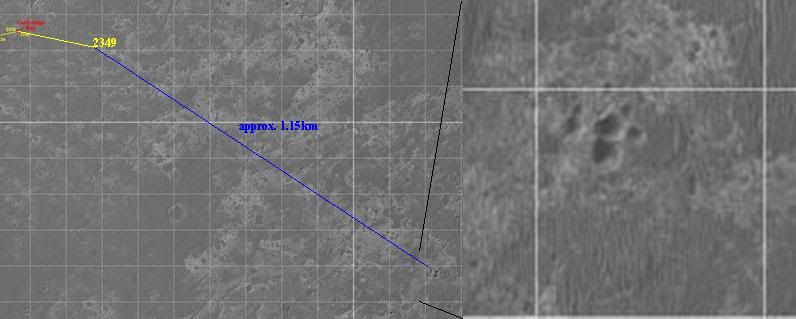
Or eight! Here's a better image taken from GE.
Click to view attachment
And what a coincidence. I saw the group some time ago and I'm actually using it as a "control point" (named "Triplet") for my tool which automatically generates the KML version of the route map. These "control points" are used to interpolate/extrapolate the lat/long coordinates of the actual route points.
(leans over from the back seat)
Oh wow! Can we go there? Can we? can we? Can we?
Oh wow! Can we go there? Can we? can we? Can we?
QUOTE (Tesheiner @ Sep 3 2010, 10:20 AM)
Or eight!
Reminds me of Morasko (Poland) set of 7 craters: wikipedia article
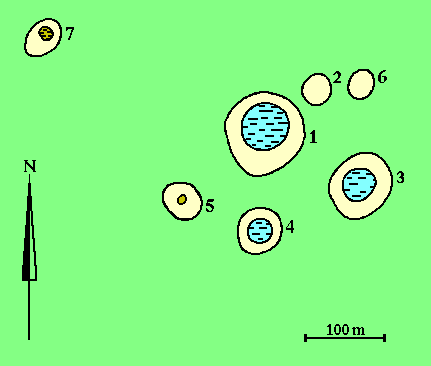
... and just to give a sense of scale, here's "Oppy" (scale correct, it's cloned from the same HiRISE image) next to the craters...
Click to view attachment
Click to view attachment
Great Stu. Comparing the sizes gives you the sense of how thin is Mars' atmosphere to allow creation of group of such small craters.
I wonder if the fact that parent body of that crater group broke up/exploded before impact would mean there is gonna be (or was in the past) a large number of meteorites on the ground.
I wonder if the fact that parent body of that crater group broke up/exploded before impact would mean there is gonna be (or was in the past) a large number of meteorites on the ground.
*glances at Scott's blog*
When was the last time Oppy drover over 100m?
When was the last time Oppy drover over 100m?
QUOTE (Stu @ Sep 3 2010, 07:41 PM)
... and just to give a sense of scale, here's "Oppy" (scale correct, it's cloned from the same HiRISE image) next to the craters...
Hey, it is just a marsian cat paw. It reminds me of the footsteps of a giant cat.
So we could name them "cat paw crater"?
QUOTE (Burmese @ Sep 3 2010, 01:42 PM)
When was the last time Oppy drover over 100m?
I think the last time the rover drover over 100 m was on its way to Victoria.
QUOTE (Hungry4info @ Sep 3 2010, 02:03 PM)
I think the last time the rover drover over 100 m was on its way to Victoria.
Actually, the last time she topped 100m was on sol 1954 while she was backtracking to Block Island. I have the very specific figure 107.48 recorded in my ongoing spreadsheet, but I don't know where that came from now. The official weekly update for that sol states simply that it was "over a 100 meter (328-foot) drive".
She also drove 137 meters on sol 1864 while blazing past Porcupine.
EDIT: Found it. The 107.48 came from A.J.S. Rayl's Planetary Society rover update for July 2009.
QUOTE (Stu @ Sep 3 2010, 11:41 AM)
I think those are mounds. Compare the lighting with that on the dunes. Of course, how the mounds came to be is another matter.
If they were mounds, would they not be lit on the same side as the dunes? 
That's a very common optical illusion with planetary images. But no, they actually are craters!
Phil
Phil
QUOTE (algorimancer @ Sep 3 2010, 11:35 AM)
I think those are mounds.
Save the image to your computer and then rotate it 90 and 180 degrees. Your mounds will become craters again.
I actually tried to force my brain to see mounds and I couldn't, so the illusion works both ways.
My eyes hurt now...
My eyes hurt now...
As we keep dropping in elevation. At our current position. Are we lower then the bottom of Victoria Crater yet and would any exposed bedrock we drive upon now be the layers that might be at the bottom of Victoria???
I would say our next stop for investigation will be the group of small craters we are heading for.
I would say our next stop for investigation will be the group of small craters we are heading for.
Bobby: As best as I can tell, the lowest point inside Victoria Crater is -1451 meters below the Mars datum. That's from the Google Mars model, which, as we have seen, has some problems with the real Mars. Opportunity's current location would appear to be somewhere around -1385 meters in the same model...quite a few meters above the lowest apparent point inside Victoria. Shortly after Oppy passes Santa Maria she'll be at an elevation near to the bottom of Victoria.
As for your bedrock layers question, that is more difficult to answer. It depends on whether those layers are perfectly flat, or if they are tilting in one direction or another.
As for your bedrock layers question, that is more difficult to answer. It depends on whether those layers are perfectly flat, or if they are tilting in one direction or another.
QUOTE (CosmicRocker @ Sep 4 2010, 06:44 AM)
Shortly after Oppy passes Santa Maria she'll be at an elevation near to the bottom of Victoria.
I don't think that's right. This map shows a moderate slope of several hundred metres going down into the crater from the relatively level parking lot: http://www.unmannedspaceflight.com/index.p...st&id=20806
Sorry, ngunn. I don't understand your point. According to the Victoria Crater DEM, the lowest point inside the crater is about -1450 meters. On the map you cite, the -1450 contour crosses the future route path about 1 kilometer SE of Santa Maria. At that point Opportunity will be at the same elevation as the bottom of Victoria Crater. If the bedrock layers are actually horizontal across this region, then Oppy may be driving on the same layers of rock as would be found at the bottom of Victoria.
Well I'm just looking at that map, nothing else, and I see a labelled contour at -1700 inside the crater and contours descending for another 40 metres beyond that to the edge of the map. I can't explain the mismatch with your other information but I guess understanding where it comes from would be useful, and knowing this place it will be provided.
The question is when will Opportunity be at the same elevation as the bottom of Victoria Crater. not Endeavour.
Victoria Crater elevations from this paper:
Click to view attachment
Victoria Crater elevations from this paper:
Click to view attachment
Right. sorry!
@centsworth - Thanks for the link to the paper on Victoria. It brings back a Q I had then about Oppy's dip into Victoria: did we get deep enough to answer prevalent questions or not? IIRC we turned back when she had a problem with either voltage on a wheel or her shoulder got stiff?
Anyway, it'd be amazing and wonderful to get the rest of the evidence desired in the bottom of Victoria many kilometers down the road!
Anyway, it'd be amazing and wonderful to get the rest of the evidence desired in the bottom of Victoria many kilometers down the road!
This is a "lo-fi" version of our main content. To view the full version with more information, formatting and images, please click here.