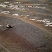
When the shadow looks like this, then it's time to start worrying!
Phil
Click to view attachment
Full Version: From Cambridge Bay to the "parking lot"
Ah, yes, those endless... endless... endless plains...
REALLY looking forward to seeing Santa Maria
REALLY looking forward to seeing Santa Maria
The OT discussion was growing several pages long so it has been moved here:
http://www.unmannedspaceflight.com/index.p...ic=6771&hl=
http://www.unmannedspaceflight.com/index.p...ic=6771&hl=
If the autonav technique requires periodic delays to download and clear flash memory, then maybe it is not worth it; regular blind drives might do better. It may be like the hare versus the tortoise scenario... (Sorry, I can't resist a little backseat driving!)
If autonav was being used frequently and successfully, I presume many of the files could be simply deleted without downloading.
Phil
Phil
QUOTE (marsophile @ Oct 15 2010, 07:11 AM) 
If the autonav technique requires periodic delays to download and clear flash memory, then maybe it is not worth it; regular blind drives might do better. It may be like the hare versus the tortoise scenario... (Sorry, I can't resist a little backseat driving!)
You're basically oversimplifying the variety and combination of how driving is done. Most drives are combinations of multiple types of drive.
I can't remember the last time we had to stand down for a few days because of full flash, can you?
And remember, applying autonav means we can drive quite a LOT further per day, taking MONTHS off the arrival date.
And lest we forget, blind drives can have their own problems. coughpurgatoryahem etc etc.
Our intrepid rover has been pointing its pancam at its planned peregrinations, so here is a view of the road ahead with a 10x vertical stretch. This can be compared with one I did like this two weeks ago, which extends this to the left. The stretch shows how the view into the valley ahead of us is really beginning to open up.
Phil
Click to view attachment
Phil
Click to view attachment
somewhat ominous tweet from Scott for those who don't twitter
marsroverdriver Scott Maxwell
Bad: dust storm headed our way. Good: it hasn't hit us yet, so we're driving anyway. Delaying drive uplink so we can wait & see on storm.
marsroverdriver Scott Maxwell
Bad: dust storm headed our way. Good: it hasn't hit us yet, so we're driving anyway. Delaying drive uplink so we can wait & see on storm.
Thanks for posting that, Phil. Just to clarify, your new stretch is from sol 2374 (actually a sol earlier than your stretch of two weeks ago). We've driven quite a bit since then, so hopefully we'll see a new horizon pan soon that'll show even more.
Right, I never pay any attention to actual dates! But it was clear that this matched the previous one quite closely, so I saw it wasn't very different in time.
Phil
EDIT - in fact, here is a combination of the two views.
Click to view attachment
Phil
EDIT - in fact, here is a combination of the two views.
Click to view attachment
With a ruler on my monitor screen I measured the apparent separation between the two middle distance bright patches in the image I linked to in post 335, and again in this more recent image: http://qt.exploratorium.edu/mars/opportuni...00P2421R2M3.JPG
I found the separation had increased from 34.5 to 36mm. Now if those features are actually at different distances then the widening could be due to the viewing angle. However if they are at the same distance then the measurement implies that we have travelled around one twenty-third of the distance towards them between those two views. How far did we drive? I don't know, but if it was about 100m that would place the features a bit over 2km away.
I found the separation had increased from 34.5 to 36mm. Now if those features are actually at different distances then the widening could be due to the viewing angle. However if they are at the same distance then the measurement implies that we have travelled around one twenty-third of the distance towards them between those two views. How far did we drive? I don't know, but if it was about 100m that would place the features a bit over 2km away.
Pancams of meteorite Ireland will (sorry not yet) finally come down ... for Stu's pleasure ("Enjoy these pics (these were navcams) therell be no more taken of this meteorite until the day people actually track it down in the Meridiani desert, in probably a centurys time..."). 
02374 p2540.26 0 0 0 3 1 4 pancam_ireland_L257
02374 p2540.26 0 0 0 3 1 4 pancam_ireland_L257
Fear not. Stu now has the ability to stack as well as access the PDS. Some nice stacked full res navcams a few months from now should add to his collection nicely.
Yep, looking forward to those. This was the best I was able to make out of the raws...
Click to view attachment
Click to view attachment
Marsroverdriver on Twitter: "OK, that's more like it. Martian weather cooperated, and we're back on the road. 100.69m today. Woo-hoo! So nice to see 3 digits again. :-) "
Woof! Looking forward to some pics... I've been getting the shakes here.
Phil
Woof! Looking forward to some pics... I've been getting the shakes here.
Phil
Yeah! 
I'm still worried about this 'major dust storm' Scott alluded to, though. Thought there might be something up a few days back since the shadows were getting suspiciously light. Any word on the tau trend?
I'm still worried about this 'major dust storm' Scott alluded to, though. Thought there might be something up a few days back since the shadows were getting suspiciously light. Any word on the tau trend?
There's been a slight increase in tau. It is still quite moderate for this season (0.6).
The exploratorium is back online. Here're the latest navcams including those taken after the last drive.
Nice shot of the IDD. Any idea what they're looking for? Wear and tear on the RAT?
QUOTE (ngunn @ Oct 16 2010, 11:16 PM)
I found the separation had increased from 34.5 to 36mm.
And again to just over 37mm in today's image. I'm becoming more convinced this is indeed Santa Maria now. I'll collect the 3 images here in case anyone wants to start 'Santa Maria - the movie'
http://qt.exploratorium.edu/mars/opportuni...W8P2420R2M1.JPG
http://qt.exploratorium.edu/mars/opportuni...00P2421R2M3.JPG
http://qt.exploratorium.edu/mars/opportuni...IZP2422R2M1.JPG
QUOTE (marswiggle @ Oct 2 2010, 03:39 PM)
Are we actually seeing Santa Maria already?
I'm not sure about this but I think you may have been right. There is a bright feature in that image that looks a lot like the leftmost of the two I'm tracking now which I think may belong to Santa Maria. It's position looks consistent with the way we've moved since then too.
That image again. The bright feature I refer to is (from left to right) two fifths of the way across.
http://qt.exploratorium.edu/mars/opportuni...23P2417R2M1.JPG
QUOTE (Stu @ Oct 17 2010, 11:35 PM)
Yep, looking forward to those.
Here ya go, Stu. Ireland in all its pancam glory:
http://qt.exploratorium.edu/mars/opportuni...5M1.JPG?sol2374
rgb composite with the jpg artifacts removed
Nice... I'm away from my computer at mo so can't enjoy it properly, but yep, that will look nice on my steps :-)
QUOTE
Are we actually seeing Santa Maria already?
I'm afraid it is still too soon to start "the movie". Plotting the headings by using the data from the Tracking Interface, it shows these brighter spots are not associated at all with St.Maria. Looks like they mark our current middle horizon with a shallow slope behind them.
Click to view attachment
Strangely, you would think these spots are something big enough to pop up in the orbit imagery. But found nothing obvious.
Click to view attachment
I'm well aware this is going to be a strong contender for this weeks' "stating the bleeding obvious" award. However, I'm still going to say it!
It has just struck me looking at the pictures downloaded today that;
1) Given how far we still have to travel,
2) How far we travelled today (100.69m)
3) How much foreshortening the pictures allow for between us and Endeavour
4) How little the image changes day by day (month by month is another story)
5) It appears we still can't see Santa Maria yet
Maybe we (I) have become a little blase but if you take a step back and allow for all the above factors you realise just how big and stunning this crater is going to be. I'm really not sure HOAV will cover it!
Neil (STBO nominee - 2010)
From the most recent downlinked images... looking a bit further around the shoulder of this local rise. The vertical stretch is 10x again.
Phil
Click to view attachment
PS hey, camera operators... (you know who you are!) - how about a monochrome full (or at least half) horizon pancam mosaic one day in place of the three color minipan?
Phil
Click to view attachment
PS hey, camera operators... (you know who you are!) - how about a monochrome full (or at least half) horizon pancam mosaic one day in place of the three color minipan?
QUOTE (nprev @ Oct 18 2010, 06:27 AM)
I'm still worried about this 'major dust storm' Scott alluded to
I didn't see Maxwell call it "major" - where did you see that?Here's a bit of a storm update from Maxwell:
QUOTE
The Martian weather keeps cooperating, so we keep driving. We'll knock off another good chunk of distance today.
QUOTE (alan @ Oct 6 2010, 06:24 PM)
Don't know what's going on with the mottled area that I've circled, maybe its slightly lower and this has interfered with the formation of the N-S ripples.
On sol 2393 we were pretty close (70 m or so) north of that "mottled" area. I'm pretty sure it's visible in navcam, circled here:
Click to view attachment
It looks like an area with more loose rocks than the surroundings. I'm not sure if we had any pancam coverage of that area.
QUOTE (fredk @ Oct 19 2010, 04:48 PM)
I'm not sure if we had any pancam coverage of that area.
Based on Tman's line-of-sight image, I think these sol 2382 pancam images show the same feature, but from a greater distance than the navcam I posted:
http://marsrovers.jpl.nasa.gov/gallery/all...W8P2420R2M1.JPG
http://marsrovers.jpl.nasa.gov/gallery/all...W8P2420R1M1.JPG
It's the area stretching across much of the images, near the horizon, light in R2 and dark in R1. It might be interesting to see a colour image...
QUOTE (Tman @ Oct 19 2010, 08:27 AM)
Plotting the headings by using the data from the Tracking Interface, it shows these brighter spots are not associated at all with St.Maria. Looks like they mark our current middle horizon with a shallow slope behind them.
Interesting. Which one of the two do your sightlines go through Tman? If as your plot indicates they are actually closer than the distance I calculated from the rate of increase in apparent separation, then they seem to be widening too slowly to be at the same distance: the leftmost must be a little nearer. Viewing the raw images that seems counterintuitive, but it makes perfect sense when you look at Phil's stretch. Anyhow I just offer the suggestion that the leftmost may be the nearer to anybody searching the HiRise in pursuit of an identification
I second Phil's motion for a pancam mosaic. Maybe there's a slight rise coming up to optimize that moment?
The sightlines go through the left of the two spots. I'm going to do the same for the right one.
I still think (read "guess") that the view east will open up once we clear the exposed bedrock, in something like 500 - 800 metres. That's when I'd like a horizon pan...
About your result, Tman, are those headings from the tracking interface accurate? Could it be that there's some drift from drive to drive, that would systematically offset the angles? Could you do a similar plot, but plotting the relative angular displacements from the features in question to some fixed Endeavour rim feature? It does seem odd that there's nothing obvious at the intersection of your sightlines.
About your result, Tman, are those headings from the tracking interface accurate? Could it be that there's some drift from drive to drive, that would systematically offset the angles? Could you do a similar plot, but plotting the relative angular displacements from the features in question to some fixed Endeavour rim feature? It does seem odd that there's nothing obvious at the intersection of your sightlines.
QUOTE (fredk @ Oct 19 2010, 09:42 PM)
About your result, Tman, are those headings from the tracking interface accurate? Could it be that there's some drift from drive to drive, that would systematically offset the angles? Could you do a similar plot, but plotting the relative angular displacements from the features in question to some fixed Endeavour rim feature? It does seem odd that there's nothing obvious at the intersection of your sightlines.
That's a very good point. AFAIK some of the attitude data drift from drive to drive, so the *absolute* headings might not be really accurate up to one degree. But relative headings to e.g. the small crater on the far rim are another story.
QUOTE (fredk @ Oct 19 2010, 06:01 PM)
It's the area stretching across much of the images, near the horizon, light in R2 and dark in R1. It might be interesting to see a colour image...
I'm not sure, but could that be the area Floyd noted in post 294? If so, then there's a colour image posted by alan in 296.
Yeah, I was claiming that was the so-called "mottled" area, that we've seen orbital (including colour) images of. But we haven't seen ground images until now. I meant that it might be interesting to see a colour pancam of the mottled area...
QUOTE (Tesheiner @ Oct 19 2010, 10:17 PM)
That's a very good point. AFAIK some of the attitude data drift from drive to drive, so the *absolute* headings might not be really accurate up to one degree. But relative headings to e.g. the small crater on the far rim are another story.
Hmm..., however, here the three plotted lines for the northern feature seem to hit perfectly the same spot by using the quoted headings.
QUOTE (JohnVV @ Oct 19 2010, 01:20 AM)
rgb composite with the jpg artifacts removed
I really like this one! Very nice colour balance.
Bit of a dust storm update from here:
QUOTE
Theres been recent dust activity, but no threat to rover safety.
From Maxwell:
Allright, who can spot the shiny thing?
QUOTE
The scientists spotted something shiny, so we have to stop to IDD it. Friday... might be just a short "bump" or IDD work.
Allright, who can spot the shiny thing?
I asked Scott. He meant "shiny" as in the Firefly-lingo for "Cool and interesting", not literally shiny as in "meteorite"...
OK, who can spot the "cool and interesting" thing?
Do the experts out there see what might be festoons?
http://qt.exploratorium.edu/mars/opportuni...0M1.JPG?sol2395
http://qt.exploratorium.edu/mars/opportuni...0M1.JPG?sol2395
like this 


Lots of rocks and crud up ahead, including at least one big block, I think...
Click to view attachment
Click to view attachment
Another Nav Cam challenge from Sol 2393 - 17 Oct 2010. Should have gone to bed a couple of hours ago!! Too addictive.
Click to view attachment :-)
Click to view attachment :-)
fredk: The last time I cried wolf I ended up having to eat my words, so I am still a bit gun-shy regarding those things. But, I see what you are talking about. I'd like to have some pancams before committing. Let's wait to see what pancam_puntarenas_L257R2 and navcam_3x1_az_225_el_neg45_3bpp_crit look like tosol. 
They are already down, here and here. This is Punta Arenas.
Click to view attachment
Today's drive was basically a change of attitude since we are almost at the same site as yestersol.
Click to view attachment
Today's drive was basically a change of attitude since we are almost at the same site as yestersol.
This is a "lo-fi" version of our main content. To view the full version with more information, formatting and images, please click here.