Full Version: Paolo's Plunge
I wonder how they will maneuver Oppy around the patch of sand in front of her with the stuck steering actuator. They've found an effective way of turning on level terrain, how well will that work on the slope?
QUOTE (alan @ Sep 14 2007, 06:09 PM) 
Current Location
Click to view attachment
Click to view attachment
Great perspective Alan. Thanks for digging that up. It's obvious now why they chose this location. There is a clear shot at each of the parent layering sections all the way down to the bottom.
Has anyone tried yet to sync this sequence up visually with the layers identified at Endurance?
QUOTE (Tesheiner @ Sep 14 2007, 02:58 AM)
What about the slope angle?
What I've got from the mobility data tells me the rover is on a (at least) 15º slope.
Well, I went back to look at the slope angle map I posted a couple of weeks ago, and if you put your location on it and do a little mental interpolation between the contour lines here, 15 degrees looks about right. It should get a little steeper after they make the turn to the right.
What I've got from the mobility data tells me the rover is on a (at least) 15º slope.
I thought the plan was to turn to Oppy's left (our right), Tom. I recall that the planning team had designed a very specific route over to the exposed Cabo Verde cliff faces, and that no straying off the path was going to be allowed. The path was designed to explore the light-colored "bathtub ring" and to keep Oppy on rocky, non-sandy footing.
As I seem to recall, the plan was for Oppy to enter pretty much where she entered, turn to her left at about the level she's at, and stair-step in a couple of legs down to the base of the Cabo Verde cliffs.
Does anyone have any information indicating that this is no longer the plan?
-the other Doug
As I seem to recall, the plan was for Oppy to enter pretty much where she entered, turn to her left at about the level she's at, and stair-step in a couple of legs down to the base of the Cabo Verde cliffs.
Does anyone have any information indicating that this is no longer the plan?
-the other Doug
O'Doug: It was my recollection that the plan was to drive down and to the south, along the contact between the ejecta layer and undisturbed bedrock. At the moment I can't remember where I read that.
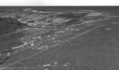
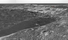
Here is the view from Sol 1293 taken inside Victoria
with the R0 Navcam.
jvandriel
with the R0 Navcam.
jvandriel
By the moment I think they will drive almost straight ahead, perhaps slightly to the left to avoid driving with the right side wheels over this patch of sand.
We should know the truth on the evening of sol 1296.
We should know the truth on the evening of sol 1296.
After studying the Jvandriel's picture to precise about the supposed safe autonomy for Opportunity. The deeper side would be on the north side along the Cabo Verde than the south side. It is possible that Opportunity would be able to transverse over little sand, about 10 centimeters of thick. However, I think that the most interested places are the vertical stones of Cabo Verde and the south side.
Yes, Alan, nice work. A good complement to Tesheiner's wonderful overhead route maps.
I've revisited the late June and early July discussions and press releases, and it seems that all anyone was prepared to be specific about at that time, in re Oppy's exact preplanned path, was that she would head down to the "bright ring" layer (otherwise referred to as the "bathtub ring") and follow it around, parallel to the crater rim, observing and sampling as it went along. While it would appear that it would be easiest for Oppy to turn to her left and follow the bright layer to Cabo Verde, and while Squyres was very clear that there was a specific path laid out "from which we will not stray," that exact path was never shared with us, the little people...
-the other Doug
-the other Doug
But it was also mentioned that they wouldn't go up to the sides of the capes because of the shadowing (sun and telecoms) they would cause.
Ah, I'm sure the intrepid rover team will manage to find the right constellation of sun and communication angles to drive up and put the instruments on a cliff face. We should use the rover to its limits down there.
QUOTE (dvandorn @ Sep 15 2007, 10:07 PM)
Oppy's exact preplanned path, was that she would head down to the "bright ring" layer (otherwise referred to as the "bathtub ring") and follow it around, parallel to the crater rim,
I have no problem with such a plan, but I would hope that the first thing they do is descend as far down the sequences as they can, ratting and sampling as many layers, as low as possible THEN go ahead and investigate along the ancient disconformity.
The dust storms reminded us that every day could be the last one for either rover, and I can't imagine anything more important geologically than a full understanding of the layering sequence as low as we can possibly go.
As far as I can tell, the most we know about where Opportunity will go and what she will investigate comes from this Aviation Week article. They point out that, after the toe dip...
I think the article also makes clear the initial scientific objective.
QUOTE
The plan is for the rover, heading south, to then drive 100 ft. into the crater. This will take several days. It will then be commanded tens of meters parallel along the crater wall. The objective will be to reach about a 1-meter-thick white rock layer that cuts through the wall of the entire crater--but at a point where it's easily sampled, not where it's also visible in the high promontories.
I can't see how they can travel parallel to the light band of rock for tens of meters unless Opportunity turns to the south to follow it across the bay.I think the article also makes clear the initial scientific objective.
QUOTE
With Victoria, "we will really be making the first good vertical slice through an impact ejecta blanket and crater walls on another planet," says Squyres.
Then they go on to say...QUOTE
This is the original Martian surface layer before the meteorite hit, burying and preserving the layer that was originally directly exposed to the Martian environment. At a minimum, the area is expected to provide direct data on the Martian climate billions of years ago. And even more, it could be (the) "bathtub ring," showing the Martin surface or ground water level at the time. If it's a surface or ground water signature, it will be important to Martian life assessments.
Thanks a lot for the entry location map, Alan. If anyone would like to visualize Oppy on the slope, Astro0's SFX image in this post shows the rover in almost exactly it's current location.
Here are a couple similar MMB views based on the drive data. The rover position is slightly off, but the scale should be more or less accurate. Astro0 had it pretty much right.
Still on the issue of "which will be the next move?" I did a manual stitch of the "drive direction" mosaic from sol 1293 using the little thumbnails available at the pancam web. As this mosaic is usually used to plan the next move(s) it might give us a glimpse of the planned path.
Click to view attachment
This image correlates with the features in the *rightmost* picture of the navcam mosaic taken on the same sol, meaning that the plan (at least when these images were taken) is to move right (southeast), not left as I thought before.
Click to view attachment
This image correlates with the features in the *rightmost* picture of the navcam mosaic taken on the same sol, meaning that the plan (at least when these images were taken) is to move right (southeast), not left as I thought before.
No new images from The Exploratorium web site since Friday. Is it down or did they take the weekend off???
Hopefully today we will get updated images
Hopefully today we will get updated images
QUOTE (Bobby @ Sep 17 2007, 07:30 PM)
No new images from The Exploratorium web site since Friday. Is it down or did they take the weekend off???
Hopefully today we will get updated images
Hopefully today we will get updated images
The Mars Odyssey spacecraft that relays most of the images went into safe mode.
CODE
0874331189:8 2007-258T13:40:54 ci2262 d:/seq/safe_mode_daily_diagnostics RELATV 47A47FFE
0874512904:2 2007-260T16:09:28 ci2262 d:/seq/safe_mode_daily_diagnostics RELATV 47A47FFE
0874513367:2 2007-260T16:17:11 ci3353 d:/seq/map_sm_recovery_reinits RELATV 97F811A8
0874512904:2 2007-260T16:09:28 ci2262 d:/seq/safe_mode_daily_diagnostics RELATV 47A47FFE
0874513367:2 2007-260T16:17:11 ci3353 d:/seq/map_sm_recovery_reinits RELATV 97F811A8
260 was yesterday - Oppy safed...nothing to worry about, just one of those things from time to time
QUOTE (djellison @ Sep 17 2007, 06:40 PM)
260 was yesterday - Oppy safed...nothing to worry about, just one of those things from time to time
I hope you meant Oddy?
Oops - yup - I did 
Doug
Doug
Are power levels still too low to permit direct transmission of images to Earth?
They could probably do short DTE sessions, but is it really worth it for the big power they consume and the DSN demand it would have? Better to have a few sit-tight days, full batteries, then on with the fun.
Here's another little experimental movie of the plunge
QUOTE (mhoward @ Sep 18 2007, 09:07 PM)
Here's another little experimental movie of the plunge
Really nice stuff mhoward, that's a great perspective for the dip and entry.
QUOTE (CosmicRocker @ Sep 16 2007, 06:39 PM)
I can't see how they can travel parallel to the light band of rock for tens of meters unless Opportunity turns to the south to follow it across the bay.
I agree with Rocker here. This is the route that makes the most sense, by keeping away from the cliffs and sampling the best defined part of the white layer (at the end of the arrows in my image). From Alan's map, here are two possible routes, the white was my initial guess, but the yellow is a possibility based on the drive direction imagery Tesheiner pointed to:Click to view attachment
Or, you never know, since they're driving downhill, maybe they'll drive straight through the patch of sand in front of us!
great movie mhoward 
New images in! On sol 1298 we seem to have arrived at the white layer, as this hazcam shows, following more or less the first leg of the white line on my projected route above.
mhoward: That animation was amazing. Really amazing.
My best guess puts Opportunity near the center of fredk's triangle.
My best guess puts Opportunity near the center of fredk's triangle.
Here a stitch from two left NavCam frames available up to now (Sol1298), showing the white layer:
Click to view attachment
This is the HazCam contest image where I highlighted the approximate area covered by previous picture:
Click to view attachment
Click to view attachment
This is the HazCam contest image where I highlighted the approximate area covered by previous picture:
Click to view attachment
I thought it might be useful to create a composite image looking at Paolo's Plunge from inside and outside.
Someone might be enterprising enough to identify various features in these images.
Fantasic view so far!
Enjoy.
Astro0
Click to view attachment
Someone might be enterprising enough to identify various features in these images.
Fantasic view so far!
Enjoy.
Astro0
Click to view attachment
I wonder if they are heading for the arrow shaped dark region? You can see the tip of it in the NavCam image.
I would say so, because the driving manouver ended with a slight right turn.
Check this composite below.
Click to view attachment
Check this composite below.
Click to view attachment
Here's my guess 
Right on the money!
Quick stitch of the sol 1298 drive direction mosaic in L2 (L5 & L7 still to come)
Click to view attachment
James
Click to view attachment
James
This looks like Endurance, minus one detail: the blueberries
Where are they ? Have they all rolled down, or are they burried in a deeper layer ?
Where are they ? Have they all rolled down, or are they burried in a deeper layer ?
Hunt down Steve's lecture to the Open University last year - he talks about Berries on the way to Victoria. Essentially they think that we're up section here - above where the berries have been made.
Doug
Doug
QUOTE (jamescanvin @ Sep 21 2007, 06:18 AM)
Quick stitch of the sol 1298 drive direction...
James
James
I'll be very curious to learn the difference between this bright layer and the darker layer further down. Evaporite versus lack of evaporite? Differing salts in the evaporites? From a distance, this seems the major geological feature in the bedrock hereabouts. Has MiniTES weighed-in on the question yet? Or has Oppy been too far away?
If Oppy is currently "above where the berries were made" then she would have to be higher than the northern edge of the crater since the surfaces in and around Bahia Blanca and The Valley Without Peril were covered in berries (as is fairly clear in this stitch of The Valley by Ant103 ). I don't think we are higher but I'm open to correction.
Just remembering an early interpretation of the berry distro - not saying it explains everything we see. Covered in berries doesn't mean full of berries (although that image would suggest some berries erroding out of rock) . It's no secret that the berries seen within rocks got smaller, and then vanished, as we headed south from Endurance.
Doug
Doug
QUOTE (TheChemist @ Sep 21 2007, 12:29 PM)
This looks like Endurance, minus one detail: the blueberries
Minus the RAT holes, too. When Steve said they wouldn't deviate from the path to the band, he really meant it...
Thanks Doug, I remember I watched that at the time, and I actually discovered the talk on my hard drive.
So the berry layer should be 5-10m lower in the crater, as SS mentioned. It would be nice to see it as we go deep down. Go girl
PS. I just saw helvick's post. SS said in the talk that berries were thrown out during victoria's creation and that's why they reappeared once we got close to the crater. So still, the berry layer should be found deeper inside the crater.
I don't know whether we should be surprised or not about how agressive they're driving into VC as compared to Endurance.
In one hand, they've got confidence in Oppy's capabilities increases since she left Endurance + I guess they've prioritized the white layer.
On this other hand, don't we have any interest in brushing/rating = studing what lay between the rim and the whiter layer ?
Thanks
In one hand, they've got confidence in Oppy's capabilities increases since she left Endurance + I guess they've prioritized the white layer.
On this other hand, don't we have any interest in brushing/rating = studing what lay between the rim and the whiter layer ?
Thanks
The layer above the white layer is just jumbled ejectra. Some is from deep in the crater, but there is no way to tell from what depth. So, start looking at the old top--the white layer--and then examine deeper layers further in VC.
This is the first time they've had an opportunity to examine an ejecta layer on Mars. It deserves closer study.
I agree that the ejecta layer is worth studying, but after we have studied the deeper, intact layers. It will be relatively easy to interpret the chronology of intact layers, and to recognize significant past events that precede those we have already seen in Endurance and elsewhere. It is the deepest intact layers that offer us the best chance of major discoveries, and we should proceed there with some dispatch (granted that Oppy's lifetime will be finite). After we know what's at the deepest exposures, we can then work our way systematically back up the section, filling in the blanks and ultimately doing a leisurely perusal of the ejecta blocks, being better able then to recognize their probable stratigraphic origins, including any that might be from deeper than the intact exposure.
I agree with Shaka.
This is a "lo-fi" version of our main content. To view the full version with more information, formatting and images, please click here.