I'm not sure, SL, that I am convinced of this "cemented layer". I would like to see MIs of broken fragments (10,20,or 50 grains in size) of this layer in the wheel tracks. (I don't mean compressed clods of fines that drop out of the wheel cleats.)
I certainly don't think Oppy can or should try to go "down to the bottom of Victoria". The risk of getting bogged would be too high, and there is nothing down there of scientific interest except sand. Oppy should be very wary of descending beyond the exposed plates of bedrock. Moving laterally across some sandy patch to get to other bedrock or another cape may be worth the risk, if the sand is not too fine and 'boggy'.
Full Version: Paolo's Plunge
A bit of new info in this story with a rather over-the-top title from New Scientist:
I think I see the bent brush. Compare these two images (you'll probably need a gamma tweak):
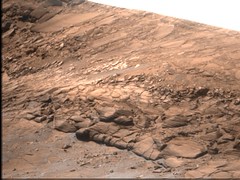
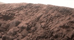
Sol 1346.
Sol 1354.
And here's a navcam view.
Oops!
QUOTE
And now another encoder on Opportunity has broken down. This one monitors the brush that clears away rock dust produced by the grinder. The rover team have worked out a way around that as well, but accidentally rotated the brush the wrong way, bending the bristles.
Some testing is needed to make sure it is safe to continue using the grinder with the bent brush. "Our expectation is that we will be able to resume grinding operations with the RAT within a couple of weeks," Callas says.
Some testing is needed to make sure it is safe to continue using the grinder with the bent brush. "Our expectation is that we will be able to resume grinding operations with the RAT within a couple of weeks," Callas says.
I think I see the bent brush. Compare these two images (you'll probably need a gamma tweak):
Sol 1346.
Sol 1354.
And here's a navcam view.
Oops!
QUOTE (fredk @ Nov 16 2007, 01:04 PM) 
A bit of new info in this story with a rather over-the-top title from New Scientist:
I think I see the bent brush. Compare these two images (you'll probably need a gamma tweak):
Sol 1346.
Sol 1354.
And here's a navcam view.
Oops!
I think I see the bent brush. Compare these two images (you'll probably need a gamma tweak):
Sol 1346.
Sol 1354.
And here's a navcam view.
Oops!
This kind of surprises me. If the motor has direction control one would think they tried running it in reverse during on-Earth testing. If during testing the motor was run in reverse, why did they not notice the brush bending problem?
Yes, but... by this time after we began the Endurance campaign, we were hearing preliminary reports about the kinds of salts that were being found in the layers of rock.
Has anyone heard a single thing about what Oppy is finding within Victoria? Or has JPL farmed out Oppy's future explorations to ESA?
-the other Doug
Has anyone heard a single thing about what Oppy is finding within Victoria? Or has JPL farmed out Oppy's future explorations to ESA?
-the other Doug
Sure. From the last PS update:
And
QUOTE
Preliminary analysis of the data on Steno indicates that this layer looks similar to other Meridiani sulfate sandstones," said Banerdt. That actually stands to reason, because this light-toned rock layer was, the scientists think, the original surface of the planet before whatever it was impacted the area and created Victoria Crater. "It should be the same as what we've been driving across for the last three, four years," he said.
And
QUOTE
"Interestingly, the blueberries in the MI images of these layers are actually microberries, 1 millimeter or less in size," said Banerdt. "These are not at all like the big juicy ones we saw as we were coming south from Endurance, when the berries got smaller and smaller until we got into the apron around Victoria and found more large blueberries sitting on the surface. Now, in the rocks at the upper reaches of Victoria, we're back to microberries. This is consistent with the hypothesis that when the impact that created Victoria occurred, it may have excavated material from deeper, material that came from rocks with larger berries and in that ejecta left those larger berries scattered around on the apron. The upper layers look like the stuff we were on before we came onto the Victoria apron. That's one hypothesis we're following here. We're wondering now if as we go deeper in Victoria we'll see larger berries?"
We're wondering now if as we go deeper in Victoria we'll see larger berries?
So they are going deeper then?
So they are going deeper then?
I would certainly expect so! We are hardly down to the strata observed in Endurance yet. We should be able to go 4 or 5 times further down the Duck Bay slope before we run out of bedrock slabs. Down there we also have the shortest width of sand to cross to reach Cabo Frio and points south.
 Keep on truckin' !
Keep on truckin' !
QUOTE (alan @ Nov 20 2007, 01:16 AM)
So they are going deeper then?
We're definitely going down to the lowest of the three sublayers of the light layer, but that's not very deep. It's not clear to me if that's what Banerdt meant by "deeper". After that, I've only heard that we may go deeper depending on what the surface looks like from up close.
QUOTE (fredk @ Nov 19 2007, 04:58 PM)
Sure...
Thanks, Fred! Though, I have to say, this isn't a lot of info. I agree that the berry size observations seem to place this layer at a similar place, stratigraphically, as the surface we've been driving on, but I'm interested in things like variations in bromine and chlorine levels in the salts. What are the layers we're looking at now telling us about where we are in the entire Meridiani sequence?
Maybe I'm just desiring too much, too soon... *sigh*...
-the other Doug
It does seem that lethargy has crept into mission PR. Steves last mission update on the Athena site was in January and the last month in review on the JPL site was to end of March. The updates mention MB and APX deployment and a hint of compositional data about the bright band layers would be refreshing.
QUOTE (Aussie @ Nov 20 2007, 06:25 AM)
lethargy
Wow. You would think after attending to two spacecraft, 24/7, 15 times longer than expected, for 6+ years (including ATLO) people might allow them a little room. There are missions and instruments that deserve a poke in terms of PR. This isn't one.
Doug
I think they have come to realize that all the information anyone needs can be found at UMSF. 
Brian
Brian
Doesn't matter what time you take the picture - it still looks like a mans face
Doug
Doug
So when does our fine, fractured friend here receive the award for "Most Studied Rock Face In The Solar System"?
Click to view attachment
Click to view attachment
QUOTE (Stu @ Nov 21 2007, 09:58 AM)
So when does our fine, fractured friend here receive the award for "Most Studied Rock Face In The Solar System"?
When we have microscopic images and elemental analysis results.
Sigh... ok Mr Picky, "Most Photographed Rock Face"... 

Sorry, Stu, I was just thinking about the special place Burns cliff
holds in MER history. It's possible that parts of the "Burns Formation"
may even be identified in Cabo Verde and still called by the Burns
name. I wonder if any new layers will be called "Duck Bay Formation"
or maybe "Cabo Verde Formation"?
holds in MER history. It's possible that parts of the "Burns Formation"
may even be identified in Cabo Verde and still called by the Burns
name. I wonder if any new layers will be called "Duck Bay Formation"
or maybe "Cabo Verde Formation"?
Indeed, could be some Martian version of 'Mount Rushmore' 
sol 1358 colorized "super resolution":
I'm always looking for new ways to combine the MER images.
This one has the brightness channel of a synthetic color L2/L6 image replaced with the sharpened average of 16 "super resolution" frames after a 2X scaling and translation allignment.
Useful to the rock guys?
I'm always looking for new ways to combine the MER images.
This one has the brightness channel of a synthetic color L2/L6 image replaced with the sharpened average of 16 "super resolution" frames after a 2X scaling and translation allignment.
Useful to the rock guys?
Great work, tonheardawho!
I made this comparison between original, your SuperRes and further sharpening...
Click to view attachment
Astro0, your shadow animations are stunning!
I made this comparison between original, your SuperRes and further sharpening...
Click to view attachment
Astro0, your shadow animations are stunning!
Animation of sol 1357 morning colorized super resolution and sol 1347 afternoon L257 image of Cabo Frio:
Frost?
You must view the original size to see the animation.
Frost?
You must view the original size to see the animation.
Looking at it more closely - it looks more like low-lighting rather than difference in the surface . The one I assume you're saying is frosty is taken on Sol 1347 14:42:41 local. Very very unlikely to be frost at that sort of time - and consistent with lighting from low in the west. Attached - the full false colour image. I can see where you might be coming from - I can see where that interpretation comes from, but I don't think it's right - particularly in the middle of the afternoon.
I'm sceptical - for one thing the colour of the "frosty" areas matches the colour of areas to the left that are clearly sunlit. I think it's just low afternoon sun glancing across the cliff face.
I don't think there has been any observation of frost on the ground by the rovers, just on the rover deck? I've been looking myself, but I think morning would be a better time.
I don't think there has been any observation of frost on the ground by the rovers, just on the rover deck? I've been looking myself, but I think morning would be a better time.
Now I'm a bit confused - which image are you suggest might be frosty Hort? (link to a JPL or Exp jpg would be best) - In the afternoon, looking in this direction, the sun would be coming from above and to the right - as that rock is almost due south. I find mid-afternoon (arguably the warmest part of the day) and frost to be a fairly unlikely combo. Even much much further north, Viking 2 only saw frost early in the morning and you can see if sublimate away very quickly, chassing the shadows as it goes.
Doug
Doug
I am suggesting that the sol 1346 image may be frost:
The 1347 image was taken at 14:42 when the sun was at 51 degrees. I made the simplifying assumptions that Cabo Frio was due south and that the sun was due west, so anything on a slope greater than 49 degrees would be in shadow.
I didn't actually measure the slopes but I asked asked Buzz and he thought the slopes were greater than that.
It is possible that the bright areas are just weird sidelighting.
Anyway, thought it would would be interesting to post the speculation.
I really don't think there's any speculation to be had with that one - I can't see any interpretation other than topography making much sense. 'frost' rendering rock in shadow the identical colour of rock in full sunlight seems unlikely. Frost at all in the mid afternoon similarly unlikely. Always worth investigation this stuff, giving it a second look - but I really can't see why this would be interpreted as anything other than light and shade.
Doug
Doug
QUOTE (Astro0 @ Nov 26 2007, 05:32 PM)
Hey Astro,
a quarter of the way across the bottom of you animation (from the left )
and about a quarter of the way up there is a dancing rock! everything else is still....
???
He's had to co-register multiple images shot in slightly different directions. What you're seing is one hot pixel that comes out white in every shot, moving around because he's shuffled each image around.
Doug
Doug
Damn! I was sure it was a mars mouse
-Floyd
-Floyd
Actually there are several 'hot pixel' spots in the full image.
The full frame animation was too large to post on UMSF conveniently and so I just picked the most interesting region with the best shadow movement. Stabilising as best I could, the pixel "mouse" just moves about.
I was intrigued in the original set of images as to why the image jumped around so much.
Was the PanCam head moving between frames taking other shots or has poor old Opportunity finally succumb to Alzheimers?! (kidding)
Astro0
The full frame animation was too large to post on UMSF conveniently and so I just picked the most interesting region with the best shadow movement. Stabilising as best I could, the pixel "mouse" just moves about.
I was intrigued in the original set of images as to why the image jumped around so much.
Was the PanCam head moving between frames taking other shots or has poor old Opportunity finally succumb to Alzheimers?!
(kidding)Astro0
A stall on the azimuth joint. Some humour, though:
QUOTE
After the stall, the rover acquired information about the atmosphere rather than the rock target with the alpha-particle X-ray spectrometer.
This is a bit of a mess - but what with the dusty optics, the crazy style of mosaicking used to make this pan, and the shear number of individual images, it's the best I could do in my small amount of free time.
Oh, and I seem to have lost access to my website (not too surprising given I left 9 months ago now) so the big versions are on a free file hosting site, I'll look into proper web hosting when I get the chance.
Lyell Panorama - Opportunity - Sols 1332 to 1352 - L257 - 112 pointings!
Quarter scale version
Click to view attachment
Full res 18.3Mb
Half res 3.2Mb
James
QUOTE (jamescanvin @ Nov 30 2007, 01:35 PM)
the big versions are on a free file hosting site
Unfortunately our college has blocked access to that site for some reason. Enjoying the quarter size though. I didn't know a complete pano was being done from here.
Not frost.
Nice anim - reminds me of the Navcam -all-day-long animations when she was parked up at Olympia. It gets ones brain into the topography as well. Very cool.
Doug
Doug
I understand that there has been some difficulty with the brush, but I was wondering if we have any indication of when Opportunity might do some rolling again. I'm kind of curious to know more about the minerals that make up the rocks below the white stripe.
 Here's looking at you kid
Nice image and really nice to have shadows again.
Opportunity is playing at shadow puppets again!
This one looks like a demented flamingo with a weird hairdo and some nasty fangs.
Click to view attachment
Astro0
PS: Now I know I'm going stir crazy
This one looks like a demented flamingo with a weird hairdo and some nasty fangs.
Click to view attachment
Astro0
PS: Now I know I'm going stir crazy
Opportunity is currently on a slope which is tilted 25 degrees to the South and Winter is approaching. At the height of Winter the Sun will presumably be low in the Northern sky. Has JPL ever given any deadlines for Opportunity to drive out of Duck bay and back onto level ground again? I wonder if there is time to cut the remaining 2 RAT holes planned in the white band before the sun becomes too low in the Northern sky to provide power to drive out of Duck bay?
What I would like to see Opportunity do next is to drive around to the Southern end of Victoria and then re-enter Victoria on a North facing slope. There presumably there would be time to throroughly investigate the outcrops below the white band.
What I would like to see Opportunity do next is to drive around to the Southern end of Victoria and then re-enter Victoria on a North facing slope. There presumably there would be time to throroughly investigate the outcrops below the white band.
QUOTE (Astro0 @ Dec 5 2007, 08:12 PM)
Astro0
PS: Now I know I'm going stir crazy
PS: Now I know I'm going stir crazy
You just need a long weekend in the Big Smoke. Sydney or the Bush!

Opportunity is near equatorial ( compared to Spirit's southern latitudes ) - and very clean - currently plenty of Whr's and I don't think it'll be getting a great deal worse.
Doug
Doug
QUOTE (PaulM @ Dec 8 2007, 09:24 AM)
Opportunity is currently on a slope which is tilted 25 degrees to the South and Winter is approaching.
Yes, I suppose this should become a concern eventually, although everyone seems to be worrying mainly, with justification, about Spirit right now. Has anyone got the predicted power levels at the winter solstice for this position? The current tilt seems to be more ESE than directly south, but it would be more northerly up against the near face of Cabo Frio or other capes further south. These locations also tend to have direct illumination in both the morning and afternoon during winter. At the far south side, it would be difficult to avoid periodic shading near the capes.
The math is getting complicated! It would be nice if we could finish our Duck Bay transect, but we have spent a lot of time here with the Smith brothers. (Could Oppy be in love? ) Whither our gallant explorer?
Edit: Well Doug offered some reassurance as I typed. Does this mean we can get through winter in Duck Bay?
You're right - the slope is ESE - so to be honest, not a lot of delta to the power. A bit of a gain in the morning - a bit of a drop in the evening.
Oppy's not so much in love, it's more a case of arthritis.
Doug
Oppy's not so much in love, it's more a case of arthritis.
Doug
This is a "lo-fi" version of our main content. To view the full version with more information, formatting and images, please click here.