QUOTE (CosmicRocker @ Oct 3 2007, 10:22 PM)

It's a very cool story. I am no mineralogist. Is there any reason to suspect its crystals would fit into the observed vugs?
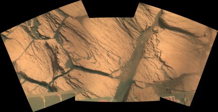
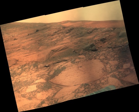
As for the "vugs," I'll agree that some of the things we are seeing in the recent MIs resemble vugs we saw back at El Capitan in Eagle Crater and other rocks right up to Endurance. But these seem noticeably smaller and less well defined than
some of those observed early in the mission.
Another thing I can't help but notice is that I really can't identify any original grain outlines in the new MIs. I understand that we are looking down onto the bedding rather than at a cross section of it, but I can't help but wonder if this rock has been significantly altered. I don't know how much the MIs have been degraded by recent dust accumulations on the lens, so that makes interpreting the raws difficult. I'd like to see some MIs of a vertical cross section next.
Agreed, it's a cool story. However, I'm not sure if it's true. The observed vugs are extremely elongated. Many, many minerals can grow with elongated habits; meridianiite (low temperature hydrated Mg-sulfate) might well be one of them, I don't know. I can, however see a different problem with the elongated vugs representing former Mg-sulfate crystals. The rock matrix, at least where the vugs were first seen, is allegedly rich in Mg-sulfate too (up to 30%). Logically, I can't see why Mg-sulfate crystals would preferentially leach out of a rock that itself is rich in Mg-sulfate - sort of like asking certain calcite crystals to leach preferentially from limestone or marble, or certain salt (halite) crystals to leach from a bed of rock salt. Where you see crystal-shaped cavities (molds), the mineral involved was typically much more soluble than its matrix (e.g., elongated gypsum-shaped molds in sandstone), or chemically unstable with regard to its matrix (e.g., cube-shaped molds in vein quartz that indicate the former presence of the iron sulfite pyrite, since weathered away). While it's possible that there were elongated crystals of meridianiite, the more hydrated form of Mg-sulfate, in a matrix of the less hydrated form, and that they became unstable on heating to just above their breakdown temperature, just above freezing, I don't find this likely over a large area or volume. It further reflects the "vaguely possible if everything went just right, but disturbingly improbable" aspect of many proposals regarding Meridiani and liquid water, IMHO. I find it much easier to hypothesize that the vugs represent a more soluble and easily leachable former chloride mineral (or some other diagenetic phase other than Mg-sulfate). Of course, cold temperatures, ice, and Mg-sulfates all seem to be common on Mars, so meridianiite could likewise be common. I'm just not sure if it explains the crystal molds.
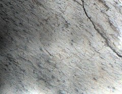
For comparison, the photo below shows elongated vugs presumably representing former crystals of gypsum, a slightly soluble evaporitic sulfate mineral, in a matrix of pure quartz sandstone:
Click to view attachmentI took this photo in May, 2003 (well before the Mars rover landings) on a Grand Canyon rafting trip (outcrops just above Deer Creek Falls at Mile 136.3). With my boot for scale, it shows rare crystal molds in the Tapeats Sandstone, interpreted as a 540 million year old beach sand deposit. In this case, some seawater presumably became locally isolated and partly evaporated enough to precipitate gypsum or some other salt, then sand was washed or blew in around the crystals, and then the sand deposit was hardened into rock (by carbonate cementation of the sand grains). The salt crystals dissolved in groundwater at some later time, leaving crystal molds in the sandstone. A similar near-shore evaporitic or sabkha environment was initially deduced for the crystal molds at Meridiani, but has since been modified (to wind-blown sulfate "mudball grains" from a dried up and vanished acid playa lake later soaked in rising and falling, evaporating and flowing brine, if I understand the highly complex proposed scenario correctly).
Regarding the much smaller size of the Victoria Crater "turkey tracks" as compared with those molds initially imaged in Eagle Crater, I wouldn't attach too much significance to this observation. It presumably indicates that whatever conditions favored crystal growth didn't last as long (or were otherwise less favorable) at Victoria. Other than size, the crystal molds look pretty similar. Although they also resemble the elongated crystal molds in my Grand Canyon photo above, logically they can't represent former gypsum, because gypsum is much less soluble than the Mg-sulfates found in the Meridianii matrix. I have no comment on the degree of degradation - even the original vugs in Eagle look pretty degraded to me.
-- HDP Don


 Ignoring crystallography, the vugs might represent frost-leached or heavily-hydrated former chloride crystals, such as antarcticite or hydrohalite (both unstable much above the freezing temperature of water), or they might instead represent so-called meridianiite:
 Thanks for pointing that out. After a little Googling I see that the earthly occurance of the mineral seems to have been discovered by the same Canadian guy who created the stuff from epsom salt solutions in his garage in the winter, and then went out to find it in the field. I recall reading about the garage experiment last year, but hadn't heard about the field discovery. It's a very cool story. I am no mineralogist. Is there any reason to suspect its crystals would fit into the observed vugs?

 . They both already have several ultrathin tungsten needles fitted to bleed-off electric charges into the atmosphere.