Full Version: Victoria and her features
So far images of Victoria - from orbit and from the ground, as Oppy approaches - have been tantalising at best, and frustrating at worst. What does everyone think we've seen so far, and what features do you think we'll see as Oppy approaches and later, when she finally arrives?
Good topic, Stu. I'm doing catch-up work after being out of town and am running short on time, so let me start off by posting the three images of Victoria that have been in use for several months.
--Bill
--Bill
Hi Stu,
Thanks for starting a new thread. For what it's worth here is my xeyed Victoria study:
http://www.unmannedspaceflight.com/index.p...=50726&st=285&#
Click to view attachment
Thanks for starting a new thread. For what it's worth here is my xeyed Victoria study:
http://www.unmannedspaceflight.com/index.p...=50726&st=285&#
Click to view attachment
A new image is included in the most recent release:
http://www.msss.com/moc_gallery/s05_s10/im...5/S0500863.html
Phil
http://www.msss.com/moc_gallery/s05_s10/im...5/S0500863.html
Phil
Can anyone locate Opportunity on the image to which Phil posted a link?
Bob Shaw
Bob Shaw
QUOTE (Bob Shaw @ Apr 15 2006, 04:11 PM) 
Can anyone locate Opportunity on the image to which Phil posted a link?
She is not visible in that image. She is off to the left of the image.
QUOTE (Phil Stooke @ Apr 15 2006, 04:05 PM)
A new image is included in the most recent release:
http://www.msss.com/moc_gallery/s05_s10/im...5/S0500863.html
Phil
http://www.msss.com/moc_gallery/s05_s10/im...5/S0500863.html
Phil
Those dark streaks off the north side of Victoria weren't there before, were they? Maybe that's something worth investigating.
QUOTE
Those dark streaks off the north side of Victoria weren't there before, were they? Maybe that's something worth investigating.
More about this streaks ...
- http://www.unmannedspaceflight.com/index.p...topic=1530&st=0
Victoria and her features, ....what will we see when we get there?
QUOTE (Bob Shaw @ Apr 15 2006, 06:11 PM)
Can anyone locate Opportunity on the image to which Phil posted a link?
Bob Shaw
Bob Shaw
Like this?
Source image: http://www.msss.com/mars_images/moc/2006/01/24/ (released on Jan 24)
Just a bit of fun... know it's not even 5% accurate, just a fantasy "Kodak Moment" 
What we might see
What we might see
Hi Stu,
Cruise around the crater edge at 600x using StereoPhotoMaker. Breathtaking.
Click to view attachment
Cruise around the crater edge at 600x using StereoPhotoMaker. Breathtaking.
Click to view attachment
All the orbiter images of Victoria lead to the question: Does anyone know if the geometry of these images differs enough that the mapping gurus will be able to derive a photogrammetric Digital Elevation Model of Victoria.
I know there's a DEM of the west half, but only MOLA data for the east half (Pertinax used them both in the discussion of visibility in Victoria on the Horizon).
It would be nice to be able to fill in the gaps of the MOLA data across all of Victoria.
It seems Promethius answered my question before I even posted it. There is stereo detail there.
I know there's a DEM of the west half, but only MOLA data for the east half (Pertinax used them both in the discussion of visibility in Victoria on the Horizon).
QUOTE (Pertinax @ Mar 31 2006, 11:34 AM)
Caution on the MOLA data: Note that Victoria is not particularly well represented in the MOLA data. What we are seeing is one or two MOLA data points from somewhere inside Victoria being interpolated over to the nearist MOLA data points somewhere outside of Victoria (not necesarily from the rim)....
-- Pertinax
-- Pertinax
It would be nice to be able to fill in the gaps of the MOLA data across all of Victoria.
It seems Promethius answered my question before I even posted it.
There is stereo detail there.
Prometheus,
Outstanding image, thanks!
"Cruising" around that rim as you suggest proves that there's a lot of modification going on - there are several places where material has slid down into the crater, changing the appearance and profile of the edge. This seems to be a very dynamic place. Might be - as others have pointed out - a dangerous one too. Oppy will have to tread very carefully as she edges around Victoria.
Stu,
I agree, the images are truly awesome. But I don't see any modifications between the images, only parallax effects. Any places where material slid into the crater look much the same in both images, but only displaced and stretched by the different perspective.
I agree, the images are truly awesome.
But I don't see any modifications between the images, only parallax effects. Any places where material slid into the crater look much the same in both images, but only displaced and stretched by the different perspective.
Steve,
Really? I think I can see several places where wasting has occurred - the actual shapes of some of the outcrops has changed. Can't point you to them right now; Dr Who's about to start here in the UK...!
Really? I think I can see several places where wasting has occurred - the actual shapes of some of the outcrops has changed. Can't point you to them right now; Dr Who's about to start here in the UK...!
MOLA meets Victoria
I think it's worth to mention it. Note Pertinax' Victoria profiles:
- http://www.unmannedspaceflight.com/index.p...indpost&p=48507
- http://www.unmannedspaceflight.com/index.p...indpost&p=48607
- http://www.unmannedspaceflight.com/index.p...indpost&p=48635
I think it's worth to mention it. Note Pertinax' Victoria profiles:
- http://www.unmannedspaceflight.com/index.p...indpost&p=48507
- http://www.unmannedspaceflight.com/index.p...indpost&p=48607
- http://www.unmannedspaceflight.com/index.p...indpost&p=48635
Agree with Steve. There're no evidences for recent edge slumping.
These two images show a very small period of Mars time. There it have to be few debris visible at least.
Apropos debris, Victoria seems to be a relatively young crater in comparison to Erebus, but all-around debris of the impact ablated and disappeared because the impact took place millions years ago maybe.
Didn't the MGS imaging team announce they'd actually imaged gully formation and dust slides - on images taken several months (or was it years?) apart - last year? I seem to remember that being a big deal at the time...
Maybe just seeing what we - I - want to see, but it doesn't seem impossible to me, if only because of the obvious fragility of the structures we can see extending into the crater from its edge. Undercut them with wind - something's making those dunes on the crater floor - long enough and they'd get a bit doddery, surely?
Only one thing for it - redirect MRO to fly-over Victoria immediately, we demand it!
Seriously tho, even if there's no modification going on here, Victoria is going to be absolutely fascinating close-up.
QUOTE (Stu @ Apr 15 2006, 07:17 PM)
Didn't the MGS imaging team announce they'd actually imaged gully formation and dust slides - on images taken several months (or was it years?) apart - last year? I seem to remember that being a big deal at the time...
Yeah there are some images of recent chances from the MOC.
These structures that extending into the Victoria crater could maybe a bit undercut - but my guess is they don't. But either way - your image of hanging edges is a great vision!
Not willing to tread on your toes, prometheus - I was doing this while you sent your definitive version of Victoria in 3-d, thanks for it!
This is showing a bit larger area. Only a crude x-eyed handiwork, using the new MGS image and one of those older ones in B. H.'s composite above. What amazes me is the absolutely flat surroundings of VC, and all of a sudden this tremendous abyss. VC must be some kind of a collapsed crater.
edit: See post #25 below for more usable version, friendly converted by Bob Shaw.
QUOTE (prometheus @ Apr 15 2006, 12:36 PM)
Wow, I know that vertical scale must be exaggerated, but that seems to be one heck of an overhang between 10 and 11 o-clock (and generally in that quadrant). Then there's the crater on the rim at the bottom - surely that happened after Victoria formed, so why isn't the rim more distorted in its vicinity? Gotta see that up close. I don't see any safe means of entering Vicky. Hopefully it will look more accessible once Oppy gets there.
I checked the data on images R1400021 and R2200640 at the USGS catalog of MOC images and found there isn't data on image orientation, and hence on the convergence of the images.
There is, however, the altitude of the spacecraft and the slant range to the image center. A little trigonometry and we find R1400021 deviates from the vertical by 24.0° and R22000640 by 15.8°. Depending on the geometry, the images converge by anywhere from 39.8° to 8.2°. Although a larger convergence would be great, either should give enough elevation information to fill in some of the gaps in the MOLA data.
Does anyone of the experts here know a source for image orientation parameters to get a better convergence figure?
Here's a shrunken version of the image above.
If there's a way in, I'd say the on-ramp is at 9:10 (on a clock face). I see zero in the way of impact features - this is all about mass wasting.
Bob Shaw
If there's a way in, I'd say the on-ramp is at 9:10 (on a clock face). I see zero in the way of impact features - this is all about mass wasting.
Bob Shaw
Here's an animated stereo image I made from Viccy's MOC images, kind of like a smooth flicker-GIF:
QUOTE (Pando @ Apr 15 2006, 11:05 PM)
Here's an animated stereo image I made from Viccy's MOC images, kind of like a smooth flicker-GIF:
Wow! That's awesome!

Getting dizzy almost

QUOTE (Stu @ Apr 15 2006, 12:01 PM)
Just a bit of fun... know it's not even 5% accurate, just a fantasy "Kodak Moment"
What we might see
What we might see
Impressive picture.
It would be very alike since the depth of Victoria crater is around 35 meters from the surface, its depth is like a building of 13 floors.Other thing, I have realized that the rim of Victoria is not circular but zigzag. It might be due to the landslide of land (gullies) caused by the water or aeolian erosion.
Besides, the south of rim has more extension of ligther color than the north ones. The north is coverd by the dark color. I suppose that the prominent wind comes from the South east (watch the formation of ripples at the bottom) and it caused the dark tail on the northern Victoria rim.
Since the Victoria's rim has zigzag shape, I am afraid to approach to the rim since some of them might be so fragil that with the Oppy's extra weight might cause a new gully.
Rodolfo
For those who like anaglyphs
QUOTE (Bob Shaw @ Apr 15 2006, 09:29 PM)
Here's a shrunken version of the image above.
Thanks, it's better like that.
Has anyone compared the new MGS release with the earlier one for all the way from End to VC? I put the two (jpegs) side by side, and my preliminary analysis tells that there's rather impressive stereo effect all over the area. Endurance shows up as a nice dimple, and the eastern part of Erebus, visible in both images, is clearly bowl-shaped. Even some big dunes appear in 3 d.
(I'm sorry, I did not succeed in rendering more images.)
Which leads to a really interesting supposition: as far as I could see, the inside of Victoria has very similar diameter/depth ratio to that of Endurance, and accordingly, the W/NW 'ramps' of VC should be sloping at comparable angles to the southern ramp of Endurance. Maybe not so inaccessible abyss after all.

marswiggle: I think most any pair of orbiter images taken on different passes will contain stereo data, since it is unlikely that the images were taken from the same places relative to the surface. I have been slaving for several days, trying to make a useful anaglyph of Victoria Crater and the ground Opportunity must traverse to get there. Tonight I paused to catch up with the discussions here, and discovered that Malin Space Science Systems has already posted that anaglyph.
Your observation that, "...as far as I could see, the inside of Victoria has very similar diameter/depth ratio to that of Endurance..." is interesting. At first, Victoria's apparent slopes were deceiving me. It may not be as dangerous as it appears.
Your observation that, "...as far as I could see, the inside of Victoria has very similar diameter/depth ratio to that of Endurance..." is interesting. At first, Victoria's apparent slopes were deceiving me. It may not be as dangerous as it appears.
QUOTE (SigurRosFan @ Apr 15 2006, 10:47 AM)
SigurRosFan: Thank you for mentioning that. I didn't know it existed. I wish they would have provided one at full resolution. That one is beautiful, though. I think we now have at least three passes over this region, with one of them being a c-PROTO that could add detail to the area outside the crater.
QUOTE (marswiggle @ Apr 16 2006, 02:49 AM)
Thanks, it's better like that.
Has anyone compared the new MGS release with the earlier one for all the way from End to VC?
Has anyone compared the new MGS release with the earlier one for all the way from End to VC?
http://www.msss.com/mars_images/moc/2006/01/24/
Doug
Thanks for all these wonderful 3D-views of Victoria and the "What we might see"-view!
However, it seems to me that the 3D effect, the depth of the crater, has been exaggerated in all the views. Surely it cannot be that deep with respect to its diameter?! Could somebody do a more realistic cross-eye/anaglyph view of the crater, with a less exaggerated depth-to-diameter-ratio?
However, it seems to me that the 3D effect, the depth of the crater, has been exaggerated in all the views. Surely it cannot be that deep with respect to its diameter?! Could somebody do a more realistic cross-eye/anaglyph view of the crater, with a less exaggerated depth-to-diameter-ratio?
QUOTE (Bob Shaw @ Apr 16 2006, 05:29 AM)
Here's a shrunken version of the image above.
If there's a way in, I'd say the on-ramp is at 9:10 (on a clock face). I see zero in the way of impact features - this is all about mass wasting.
Bob Shaw
If there's a way in, I'd say the on-ramp is at 9:10 (on a clock face). I see zero in the way of impact features - this is all about mass wasting.
Bob Shaw
This picture in Bob's post #25 and others like it make it appear that on approach from Erebus, Oppy will come in on the difficult side if she is really going to try to descend into the crater. It is hard to gague what role is played by the lighting, but most of the other potential entrance ramps seem to be in the 2:00-5:00 sector. That would be a difficult trek around the rim, so we should hope that the 9:10 feature allows safe access. Stu's simulated images make dramatic eye candy but underscore that the engineering team will be faced with some very tough choices!
It also appears that the interior slopes all around are much sandier than at Endurance. If prospects for entry appear barely possible but without hope of exit, is there any good reason why we should not be content to see the mission end this way? Alternatively, how much science would be sacrificed by simply remainig up on the rim, given the shaky condition of the IDD and the depleted state of the Mossbauer radiation source?
Peter
I must say thanks to everyone who's contributed to this thread so far, I had no idea my "eye candy" simulated view would prompt such debate! Have to stress again that I'm not saying for a moment that that is what Victoria will actually look like - slopes not as steep, and there won't be any Dali-esque drapes and slumps of material melting over the crater's lip either - it really was just a bit of fun. Some serious points and questions have been raised tho. Just how dangerous will Oppy find it chugging along the edge? Will we see fresh landslides or even gullies tumbling down into the interior? Will it be safe for Oppy to head down into the crater? I have an image now of our brave little rover edging into the crater very nervously, like R2D2 rolling through that canyon in the first Star Wars film, hooting and beeping anxiously at every shadow and skipping stone... 
Gorgeous images everyone's generously shared too - Pando, your animation was fantastic!
One thing's clear - Victoria is an amazing place already, even with this little data to go on. The closer we get, and the clearer our views, both from the ground and from orbit, become, the more fascinating it will become. What an adventure we're all living!
Have to stress again that I'm not saying for a moment that that is what Victoria will actually look like - slopes not as steep, and there won't be any Dali-esque drapes and slumps of material melting over the crater's lip either - it really was just a bit of fun. Some serious points and questions have been raised tho. Just how dangerous will Oppy find it chugging along the edge? Will we see fresh landslides or even gullies tumbling down into the interior? Will it be safe for Oppy to head down into the crater? I have an image now of our brave little rover edging into the crater very nervously, like R2D2 rolling through that canyon in the first Star Wars film, hooting and beeping anxiously at every shadow and skipping stone... Gorgeous images everyone's generously shared too - Pando, your animation was fantastic!
One thing's clear - Victoria is an amazing place already, even with this little data to go on. The closer we get, and the clearer our views, both from the ground and from orbit, become, the more fascinating it will become. What an adventure we're all living!
wonderful view Stu! amazing..
this probably has been remarked before but the jagged nature of the rim should provide a more comfortable investigation as opposed to Endurance, while cruising the rim. I expect more close-ups à la Burns Cliff without risking slippage into the deep.
Nico
this probably has been remarked before but the jagged nature of the rim should provide a more comfortable investigation as opposed to Endurance, while cruising the rim. I expect more close-ups à la Burns Cliff without risking slippage into the deep.
Nico
Wondering if we can start putting names to some of the features we've all been drooling over..?
Thinking: the "outcrops" - that now don't look so crumbly or fragile anymore - seem to be pretty solid, with some layering and ledges, so they can probably be more accurately described as terraces... I've identified 5 "terraces" which stand out from the rest, and are already showing some detail that our ImageMages can tease out further, I'm sure...! So, going clockwise, we have Ts 1 to 5 to christen (just for our own info, not going to be the final names of course!) and the four main areas where dark material seems to be coming from along the crater's edge, well, we can call them vents possibly..?.. though they're not vents in the strictest sense of the word, I know... So, again going clockwise, we have Vs 1 to 4 to name too. Then there's the crater on the southern edge to name too.
If no-one wants to join in fair enough, I just thought it might a) be a bit of fun, a way to kill time while Oppy trundles south and Spirit enjoys a duvet season at haven, and it will help us discuss certain areas more clearly from now on.
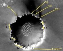
Link to larger version of "map"
Thinking: the "outcrops" - that now don't look so crumbly or fragile anymore - seem to be pretty solid, with some layering and ledges, so they can probably be more accurately described as terraces... I've identified 5 "terraces" which stand out from the rest, and are already showing some detail that our ImageMages can tease out further, I'm sure...! So, going clockwise, we have Ts 1 to 5 to christen (just for our own info, not going to be the final names of course!) and the four main areas where dark material seems to be coming from along the crater's edge, well, we can call them vents possibly..?.. though they're not vents in the strictest sense of the word, I know... So, again going clockwise, we have Vs 1 to 4 to name too. Then there's the crater on the southern edge to name too.
If no-one wants to join in fair enough, I just thought it might a) be a bit of fun, a way to kill time while Oppy trundles south and Spirit enjoys a duvet season at haven, and
it will help us discuss certain areas more clearly from now on. Link to larger version of "map"
Stu:
Here's a slightly distorted (Reverse Phil-O-Vision) version of your image, with a depth/width ratio which I think may be more realistic.
And as for names, it's obvious that Opportunity is looking out over the edge of Stu's Gulch!
Bob Shaw
Here's a slightly distorted (Reverse Phil-O-Vision) version of your image, with a depth/width ratio which I think may be more realistic.
And as for names, it's obvious that Opportunity is looking out over the edge of Stu's Gulch!
Bob Shaw
Like that a lot Bob! Much more accurate than my original.
Stu:
I'd take your terraces as a good enough description of the form of those particular outcrops, but I see more outcrops - or at least more-or-less-linear dark patches - around the rim, some radial and some concentric. These might be Burns Cliff quality exposures and would have the advantage of being easy to access. If the local beds are dipping as has been surmised, then we might, by traversing at least a minimum of 50% of the crater rim get some good stratigraphic sequences (certainly comparable to any in-crater investigation, remembering that the talus slopes and dunefield will reveal only individual rocks at best rather than their position in relation to everything else (though 'erratic' rocks like Wopmay might allow us to sample depths which otherwise would be unreachable)).
One caveat with regard to the orbital images is that they tend to accentuate features depending on the illumination - we may find that some of the external relief is much more subtle than we expect.
I've added a few features to your map showing 'my' exposures.
Bob Shaw
Thanks Bob, I agree there are many more outcrops along the rim, I just picked out the five most obvious and most detailed to start with. Figured "start small", you know? Besides, not wanting people to think I was staking some prospector's claim to Victoria!
Possible "themes" for Victoria topography nomenclature:
* Arthurian legend
* Characters from Kim Stanley Robinson's Mars trilogy
* Characters from Sherlock Holmes stories
...?
P.S. New short story about Opportunity and Victoria Crater here
Possible "themes" for Victoria topography nomenclature:
* Arthurian legend
* Characters from Kim Stanley Robinson's Mars trilogy
* Characters from Sherlock Holmes stories
...?
P.S. New short story about Opportunity and Victoria Crater here
Below, I am trying to describe the factors that influenced its present Victoria Crater shape.
About the amount of sand and visible outcrop around the Victoria crater. As the rule of thumb, (I think) the amount of sand is the result of land silhouette forms, wind direction and its strenght.
It is evident that the southern rim has lower depth (20 meters versus 30 meteres from northern rims) See Pertinex's post http://www.unmannedspaceflight.com/index.p...pic=1443&st=180
The southern VC's rim has smoother slope than the north. It might be explained that during the time when that zone had water, the water had influenced the sand deposition more tiime on the southern than the northern (vertical).
On the other hand, the northern side, has more gullies or landsliding of sand or rocks. It is explained that the northern rim has more zigzag shape and more "gullies" than the southern side.
http://www.unmannedspaceflight.com/index.p...pe=post&id=5180
Rodolfo
Victoria crater is named for Magellan's ship, the only one of five in the original fleet which completed the first circumnavigation of Earth.
I would suggest choosing names associated with that expedition, names of people, other ships in the fleet, and places associated with the voyage.
Phil
I would suggest choosing names associated with that expedition, names of people, other ships in the fleet, and places associated with the voyage.
Phil
Great idea Phil, makes perfect sense. Looks like a Googling session is in order...
Edit: a little later...
Wow, had a very quick look and there are some really poetic names we can use...
Islands (for outcrops & terraces?) : Cabo, Tenerife, Bolyna, "Thieves Island", Macangor...
Bays (for eroded areas cutting into surrounding area?): St Matthew, Port St. Julian, Carpyan, "Valley Without Peril", "Bay of Labors"...
Rivers (for any gullies found?): Rio, St Christopher, Santa Cruz...
Other misc: Mt. Saint Paul (please can we use this name for T2?), "Cape of the Virgins"...
Lots to work with just there, and I'm sure members more familiar with Magellan's voyages than I will have even more beautiful names to decorate our map with...
QUOTE (Pando @ Apr 15 2006, 11:05 PM)
Here's an animated stereo image I made from Viccy's MOC images, kind of like a smooth flicker-GIF:
What an extraordinary image - thanks, Pando! Unless the effect produced by this anaglyph is completely misleading, I can't see any way into VC - none that would leave Oppy in working order at the bottom, anyway. Personally I couldn't see much evidence of actual change in previous images pairs, but in this image there are clearly several areas where more than the lighting has changed. The sides appear effectively sheer drops in most places.
So Victoria is named after Magellan's ship? And here I have been thinking that it was named after the British Queen. Oh well...
I wouldn't fret about _how_ Oppy will enter Victoria at this point in time. A boots-on-the-ground inspection will be needed to determine that; at any rate, I suspect that Oppy will be doing 360* round-the-rim survey with Pancam panoramas before going inside for a close-up survey. I'll also suspect that the rim will generally be like the Mogollon Rim at Erebus: the gently draping evaporite over the darker units, but with steeper/taller bluffs and with several entryways.
Great imagery and thoughts; we'll be there 'fore we know it.
--Bill
All the craters at Meridiani are named after vessels of exploration.
Fram was a tender to the Endurance. Some of them are spacecraft vessels ( Eagle, Viking, Voyager, Vostok )
Doug
Fram was a tender to the Endurance. Some of them are spacecraft vessels ( Eagle, Viking, Voyager, Vostok )
Doug
QUOTE (Stu @ Apr 16 2006, 08:48 AM)
Great idea Phil, makes perfect sense. Looks like a Googling session is in order...
Lots to work with just there, and I'm sure members more familiar with Magellan's voyages than I will have even more beautiful names to decorate our map with...
Lots to work with just there, and I'm sure members more familiar with Magellan's voyages than I will have even more beautiful names to decorate our map with...
I'm sure Ustrax can help out here. With all due respects to Senhor Magellan, I would make the following humble suggestion, hoping that it might appeal to JPL, if not UMSF..
Assuming that we reach it, and it is a crater, and we can take a panorama of it for her to show to her grandchildren:Click to view attachment
I would anticipate that we will, if possible, try to circle at least half the rim to get a thorough view of the Victoria interior before we enter. Thus it could well be that Sofi's crater will be close to the point where we enter Victoria. Perhaps there will also be some preference for the south, north-facing, upwind (?), less-sandy (?) crater wall? I wouldn't be surprised, at this early juncture, if the T3 area became one of the first study sites.
Speculation is loads of fun.
QUOTE (Bill Harris @ Apr 16 2006, 02:26 PM)
So Victoria is named after Magellan's ship? And here I have been thinking that it was named after the British Queen. Oh well...
I wouldn't fret about _how_ Oppy will enter Victoria at this point in time. A boots-on-the-ground inspection will be needed to determine that; at any rate, I suspect that Oppy will be doing 360* round-the-rim survey with Pancam panoramas before going inside for a close-up survey. I'll also suspect that the rim will generally be like the Mogollon Rim at Erebus: the gently draping evaporite over the darker units, but with steeper/taller bluffs and with several entryways.
--Bill
I also thought it was named after the "virgin queen", and was hoping that the name wouldn't turn-out to be prophetic as regards being able to get into the crater (tiptoeing around political correctness here...). We'll find out soon enough
This is a "lo-fi" version of our main content. To view the full version with more information, formatting and images, please click here.