Full Version: Victoria and her features
The contrast is pumped up a little more on the 2 May image, but they are both original scale cropped from exploratorium images. That's why I said unstretched.
I really would like to hear from the other imagery maestros about the changes that have occurred in the dimensions of Victoria Beacon since we first saw it. Tesh, Dilo, Doug, Rodolfo, and anyone willing to chime in?
Come on lads! Either you trust your own eyes and your technology or you don't... What's it to be?
Edit note: Out of courtesy and respect I will add hortonheardawho to the above list. I understend if he feels constrained to reply at another node in this miraculous global internet.
Come on lads! Either you trust your own eyes and your technology or you don't... What's it to be?
Edit note: Out of courtesy and respect I will add hortonheardawho to the above list. I understend if he feels constrained to reply at another node in this miraculous global internet.
QUOTE (Shaka @ May 16 2006, 12:36 AM) 
Come on lads! Either you trust your own eyes and your technology or you don't... What's it to be?
Yeah, how long are you going to let us wallow in the dust? And how is that request for a right angle drive (to the beacon sight line) coming?
QUOTE (Joffan @ May 16 2006, 12:26 AM)
The contrast is pumped up a little more on the 2 May image...
No image expert I, but couldn't boosting the contrast on such a noisy image cause a false enlarging of a light spot?
Based on this:
http://gallery.perfext.com/displayimage.php?album=2&pos=70
and this:
http://gallery.perfext.com/albums/userpics/10001/vc5.jpg
I put together this:
Click to view attachment
At least the dark rays on the left side match up. The creator (A1call on the Yellow forum) feels the elevated far hill is real but not as high as indicated.
The images suggests the beacon is not on the crater rim
QUOTE (prometheus @ May 15 2006, 08:06 PM)
The images suggests the beacon is not on the crater rim
Nor is anything else visible in the pancam images, if I read you correctly.
Between the "dark rays" and the background hills (a small far hill, a large far hill, a larger far hill, and a far far hill), Victoria Crater is sunk into an invisible... an invisible...abyss?
Paging Dr. Ustrax..paging Dr. Ustrax...pick up line 3 please...
QUOTE (Joffan @ May 15 2006, 09:55 PM)
On one shot a little while back, when I posted a stereogram, the right eye picture showed the beacon and another spot of white a little further along. I wonder if we have seen the second beacon sometimes?
Joffan, could you find the image? It would be very interesting to analyze it!
About beacon images comparison, I reccomend to use my previous post sequence because pictures were assembled with the similar degree of contrast enhancement and noise reduction (apples to apples)...
PS: I already estimated the visible part of beacon should be 1m tall if located on the far rim, less if elsewere.
[quote name='Shaka' date='May 16 2006, 05:01 PM' post='54294Victoria Crater is sunk into an invisible... an invisible...abyss?[/quote]
Invisible abyss? Where did you get that from? I take you didn't look at this:
http://gallery.perfext.com/albums/userpics/10001/vc5.jpg
or read this:
http://gallery.perfext.com/displayimage.php?album=2&pos=70
Both the pamcam and the 3d generated image show the land dropping away to the left where the dark streaks are located. So why assume the land behind Victoria is flat and doesn't rise up? Do you have access to detailed elevation contour line data? Also the lower elevation to the left may help to explain the dark streaks as this lower height side of the crater may have formed a wind tunnel effect for exiting winds.
Click to view attachment
QUOTE (centsworth_II @ May 16 2006, 05:54 AM)
Yeah, how long are you going to let us wallow in the dust? And how is that request for a right angle drive (to the beacon sight line) coming?
I'd rather make 30m more progress to Victoria than have a 30m baseline for fairly useless imagery at this distance

Doug
QUOTE (centsworth_II @ May 16 2006, 05:13 AM)
The problem I see is that any deviation of Opportunity from the ideal line of sight through such a gap should block out the view of the far rim and extinguish the beacon. If the gap is wide enough to prevent this, the beacon should widen or narrow depending on how well Opportunity is lined up with the gap. But ever since the beacon was spotted, it has maintained its presence and size despite opportunity's deviations from a straight-line path to it.
Another problem I see with the "gap theory" is that it requires an exact vertical alignment between the near and the far rim. If the far rim is lower then the near rim (in the current line of sight) nothing would be seen through the gap, if it is higher, we would see not only the beacon through the gap but many other features over and around it.
QUOTE (centsworth_II @ May 16 2006, 05:13 AM)
Any chance of getting the rover drivers to take a hard left or right and drive as far as it takes to get an unambiguous answer by parallax? 
No chance, I would say.
But following the "proposed path" on the route map to a point 300m S of the current position, I estimate the angular difference between the beacon's expected positions at either the near or far rims to be more then 3.5º (see headings in red on the following image). That would be more then enough to rule out one of the options.
Click to view attachment
But following the "proposed path" on the route map to a point 300m S of the current position, I estimate the angular difference between the beacon's expected positions at either the near or far rims to be more then 3.5º (see headings in red on the following image). That would be more then enough to rule out one of the options.
At current speed that means another 18 sols including a 10 days of restricted sols which means an answer by june 10 th? Even if it will be Spirit launch Birthday (as well as my son's) we just CAN'T wait that long.
At current speed that means another 18 sols including a 10 days of restricted sols which means an answer by june 10 th? Even if it will be Spirit launch Birthday (as well as my son's) we just CAN'T wait that long.
"....and now the poor litte thing has shrivelled away to nothing - pancam, 14-May, no stretch...."
Obviously, the Beacon is the Periscope the Grays have been watching us with from their base in Victoria crater and they've retracted it when they realized we'd spotted it......"
Yes, Nurse.. I did take my meds today... No...!... Not the Straigjacket!... arrrrgg.
Obviously, the Beacon is the Periscope the Grays have been watching us with from their base in Victoria crater and they've retracted it when they realized we'd spotted it......"
Yes, Nurse.. I did take my meds today... No...!... Not the Straigjacket!... arrrrgg.
I guess this will look weird! Anyway. We know where the heat shield has landed as well as the parachuttes. Is there any chance that the "bus" that brought Oppy to Mars make it through the atmosphere and landed on VC rim (I mean FAR rim  ) (a nearly-hole in one) and show now as the beacon?
Frankly, as Oppy was slowed down by the heatshield, I think that the bus went further on the trajectory, but I'll be interested both in your comments about survivability of the bus as well as its trajectory. Just wondering if this has been addressed in the forum. Thanks.
) (a nearly-hole in one) and show now as the beacon? Frankly, as Oppy was slowed down by the heatshield, I think that the bus went further on the trajectory, but I'll be interested both in your comments about survivability of the bus as well as its trajectory. Just wondering if this has been addressed in the forum. Thanks.
I've been trying to figure out where the bus would have ended up - and I think actually - (after one considers that it's such a complex structure with such a variety of materials that it is essentially impossible to calculate this) it would have mostly burnt up, with some remaining debris falling short of the landers.
Consider the size of the cruise stage compared to its weight. The MER entry capsule was actuall quite 'dense' so it would want to push it's way through the air for longer (i.e. more kinetic energy per unit of drag )
BUT - there are parts of the cruise stage ( fuel tank, thruster clusters ) that would have survived much of entry I'm pretty sure...but until they 'fell off' the cruise stage ( which when they're bolted on strong enough to survive launch and a 60rpm spinup is going to be quite 'late' in the entry ) they would have slowed down quite quickly with the rest of the cruise stage. Thereafter they'd probably have just dropped to the surface.
All this however - constrains the debris in the line of flight - (i.e. down the long axis of the landing ellipse - roughly East-West) - so I can't imagine the cruise stage debris being >6km (and out of the landing ellipse ) to the South
BUT - all that is pure speculation. If there WERE any cruise stage debris, its impact ( typically objects hit the martian surface at 200mph..ish) would have created the sort of ejecta we saw for the heatshield impacts both at Meridiani and Gusev - both highly visible in MOC imagery.
Doug
There is a very dark spot slightly north east of Vostok in the MOC image that does look a little like the heatshield imapct site.
This one (lower left of cProto image) looks nice and fresh and is due West of the landing location. Looks too big though, IMO.
Back to Victoria, does anyone have any idea how common it is to have craters this large/deep without much of a raised rim? Could the "porous" nature of the evaporite be responsible for this?
Back to Victoria, does anyone have any idea how common it is to have craters this large/deep without much of a raised rim? Could the "porous" nature of the evaporite be responsible for this?
QUOTE (babakm @ May 16 2006, 06:28 AM)
does anyone have any idea how common it is to have craters this large/deep without much of a raised rim? Could the "porous" nature of the evaporite be responsible for this?
I don't know yet that we are seeing a large crater without much of a raised rim. How high does the rim for the crater in Arizona look from a mile away?
QUOTE (babakm @ May 16 2006, 01:28 PM)
This one (lower left of cProto image) looks nice and fresh and is due West of the landing location. Looks too big though, IMO.
And not to mention:
Image start time: 2003-11-08
More than two months before Oppy arrived
Doug
QUOTE (djellison @ May 16 2006, 12:42 PM)
And not to mention:
Image start time: 2003-11-08
More than two months before Oppy arrived
Doug
Hah! But it doesn't say anything about image end time! May be it was a reeeeaaal slow and careful cProto.
A little experiment here... I made a strictly square xeyed image of Victoria from JPL jpegs R2200640, S0500863 (hope I got the codes right) and added a faint grid as an artificial 'zero level', to find out relative heights around the rim.
I'm not going to speculate, but if you look carefully you can tell the high and low points of the rim. Of course supposing that stereo data in JPL images is to be relied on.
Save the image and try it also south up!
I'm not going to speculate, but if you look carefully you can tell the high and low points of the rim. Of course supposing that stereo data in JPL images is to be relied on.
Save the image and try it also south up!
QUOTE (antoniseb @ May 16 2006, 06:32 AM)
I don't know yet that we are seeing a large crater without much of a raised rim. How high does the rim for the crater in Arizona look from a mile away?
I remember driving to see the Barringer Crater in Arizona when I was a kid. It is fairly unimpressive from a distance. It looked like a row of hills, not the dramatic angled crater rim I expected. I revisited it when I was about 40 years old and it still did not look much like a crater from the road.
Scott
Interesting stereogram, marswiggle. I can clearly see that NW rim is the most elevated and I have impression that the promontory in the far rim is really tall! this explain crater "tilted" profile and supports distant beacon position.
QUOTE (babakm @ May 16 2006, 08:28 AM)
This one (lower left of cProto image) looks nice and fresh and is due West of the landing location. Looks too big though, IMO.
Back to Victoria, does anyone have any idea how common it is to have craters this large/deep without much of a raised rim? Could the "porous" nature of the evaporite be responsible for this?
Back to Victoria, does anyone have any idea how common it is to have craters this large/deep without much of a raised rim? Could the "porous" nature of the evaporite be responsible for this?
Wow, that does look very fresh. And what is all the dark speckling? It gets denser near the bottom of the image.
It's just me, or the "beacon" looks bigger on sol 821 pancams? 
That would mean:
a: Lower parts of if being visible through a nearby gap/hollow.
b: Compression artifacts.
c: <Feel free to complete options c, d, etc.>
Click to view attachment
Original images: sol 818, sol 821.
That would mean:
a: Lower parts of if being visible through a nearby gap/hollow.
b: Compression artifacts.
c: <Feel free to complete options c, d, etc.>
Click to view attachment
Original images: sol 818, sol 821.
As we changed our position a little in eastward direction, it could be now more visible through a nearby gap.
QUOTE (ustrax @ May 12 2006, 10:43 AM)
dilo, I've picked up your enhanced version and blow it...
It may be a mistake but it looks like there are other bright features surrounding the main beacon:
http://i16.photobucket.com/albums/b14/ustrax3/beacon.jpg
I've given some temporary names to the features just for easier reference.
As the word beacon appeared I remember the alexandrian one, so, the names presented here are related to that wonder of the ancient world.
Is Sostratus becoming more visible at the right of the Beacon or is it only an artifact?:
http://qt.exploratorium.edu/mars/opportuni...3FP2412L2M1.JPG
It's just me, or the "beacon" looks bigger on sol 821 pancams?
Ustrax is also saying the same.
Ok, we're talking of a few pixel feature, nevertheless, if I refer to Teshinger maps showing the 2 possibilities, (Post #259 same topic, yesterday) this "new observation" could be better explained by the far rim obtion. The Far rim obtion show a bright south-west face. The general dirrection Oppy is roving will show more and more of this bright face. Another argument will be that there is a "summit" about 45-50 meters on the north west of the far rim beacon. The south-west face of this summit is much darker than the beacon so it can explain the dark feature we're seing on the right of the beacon.
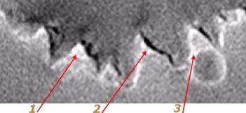
I have a few candidates for the location and identity of "Beacon"
http://img.photobucket.com/albums/v509/cum...nsky/beacon.jpg
If...
#1: "Pyramid"... most likely, I think, as it has an obvious high elevation above the crater rim, and looks the most substantial. It's also the most likely to be seen from our current viewpoint, I think (IMHO). It must be pretty tall because there's quite a shadow on the crater slope beneath it.
#2: "Raptor Claw Cliff"... the one I'd most like it to be, I think, because it means that we're presently seeing this curved cliff with a raised top almost face-on, and it should open up and broaden as we approach, whether we drift east or west.
#3: raised edge of "Sofi Crater". Another possibility, I think, but only makes sense if Sofi Crater (as someone suggested we call it, I recall?) was formed after Victoria, and the impact pushed material from Victoria's apron up into a ridge. I'm sure others here know more about that than I.
So, my take: a far rim feature.
Okay, fire away!
QUOTE (ustrax @ May 17 2006, 09:48 AM)
Is Sostratus becoming more visible at the right of the Beacon or is it only an artifact?:
I think they are artifacts. Blowing up the last pic from sol 821, it's nothing really visible beside the "beacon".
This might help...
Thanks Stu,
The Far rim obtion "1" in your picture show a bright south-west face. The general dirrection Oppy is roving will show more and more of this bright face. There is a "summit" about 45-50 meters on the north west of the far rim beacon "the one not labbeled on the left of 1". The south-west face of this summit is much darker than south-west face of the beacon "1" so it can explain the dark feature we're seing on the right of the beacon on the pictures taken by Oppy from where she is now.
Edit : Tesheiner's post and mine appeared at the same time. If I refer to what he says, I'm totaly wrong.
re-Edit : if I refer to others, I may be right
QUOTE (Stu @ May 17 2006, 12:24 PM)
This might help...
It can't be, Stu.
Assuming the feature #2 is the beacon, this is where they should be on a pancam image. The separation between all of them is currently 5º; it corresponds to a lot of pixels.
Click to view attachment
QUOTE (Tman @ May 17 2006, 11:22 AM)
I think they are artifacts. Blowing up the last pic from sol 821, it's nothing really visible beside the "beacon".
So...Don't blow it!
QUOTE (Tesheiner @ May 17 2006, 11:59 AM)
It can't be, Stu.
Assuming the feature #2 is the beacon, this is where they should be on a pancam image. The separation between all of them is currently 5º; it corresponds to a lot of pixels.
Click to view attachment
Assuming the feature #2 is the beacon, this is where they should be on a pancam image. The separation between all of them is currently 5º; it corresponds to a lot of pixels.
Click to view attachment
Tesheiner, Sostratus is 'clearly' asking 'how do you do?' on your image...
Sorry Teseheiner, not clear what you're saying - are you saying that none of my suggestions could be Beacon, or that #2 might be? (I'm having a thick day!)
I think the little green-skinned guys on the other side of the crater are having a laugh at our expense! They built this p*ramid thing, see, and they're moving it around at night. And to prove the validity of my theory, by the time (Sol 900) that Opportunity reaches Victoria, there'll be nothing there for us to see! The beacon will have... ...vanished.
Makes sense, dunnit. Had that H0agl*nd guy in the back of me cab last week.
Bob Shaw
Makes sense, dunnit. Had that H0agl*nd guy in the back of me cab last week.
Bob Shaw
QUOTE (Stu @ May 17 2006, 01:11 PM)
Sorry Teseheiner, not clear what you're saying - are you saying that none of my suggestions could be Beacon, or that #2 might be? (I'm having a thick day!)
No. I'm saying that it can't explain the spots which might be appearing quite near to the beacon.
Whatever we see a few pixels to the left/right of the beacon can't be #1 or #3.
Edited: IF the beacon is on the far rim, I would say it's feature #2. But for the time being I'm with the near rim hypothesis.
No. I'm saying that it can't explain the spots which might be appearing quite near to the beacon.
Whatever we see a few pixels to the left/right of the beacon can't be #1 or #3.
Aha, gotcha. Well, my gut is telling me that the beacon is my #1 or #2, probably #1, and that the other bright spots close by are details in base of the feature itself, or or even large, protruding boulders set into the rim. Thinking back to Endurance, there were quite a few chunks of rock embedded in there, weren't there?
QUOTE (Tesheiner @ May 17 2006, 01:05 PM)
But for the time being I'm with the near rim hypothesis.
By now I'm with you, if we look at this, a part of the beacon is below the near rim line, gap or no gap that is the question, let's see who will be the lord of the rims...
http://i16.photobucket.com/albums/b14/ustrax3/beacon4.jpg
QUOTE (ustrax @ May 17 2006, 11:05 AM)
So...Don't blow it!
Tesheiner, Sostratus is 'clearly' asking 'how do you do?' on your image...
Tesheiner, Sostratus is 'clearly' asking 'how do you do?' on your image...
I blow up damn sure!
Have a look http://www.greuti.ch/oppy/beacon_sol804821.jpg - there's nothing nada beside the "beacon" what you could identify more than a picture artifact...
...want you a big hug instead (or do you NEED one now)?
Note: the upper picture is a cutting from Tim Parker's (JPL) mosaic.
QUOTE (Tman @ May 17 2006, 04:51 PM)
...want you a big hug instead (or do you NEED one now)?
Not me, but I know of someone who's in need of one...
http://i16.photobucket.com/albums/b14/ustrax3/HUG.jpg
In YOUR image nothing seems to appear....That's a fact...But I will insist on my theory...
Hey, I'm ustrax! You know how things work with me!...
http://i16.photobucket.com/albums/b14/ustrax3/beacon5.jpg
(BTW, have you seen my new signature?...
)
QUOTE (ustrax @ May 17 2006, 04:09 PM)
Not me, but I know of someone who's in need of one...
Here on UMSF there's someone for sure
QUOTE (ustrax @ May 17 2006, 04:09 PM)
(BTW, have you seen my new signature?... )
)Yes, that's a good logo to our pictures, but (where) is it for downloading?
QUOTE (Tman @ May 17 2006, 05:19 PM)
Yes, that's a good logo to our pictures, but (where) is it for downloading?
I was talking about the sentence down there...
"Some men see things as they are and say why - I dream things that never were and say...it's an abyss!"
And where do you want to put our pictures? My own you can put on a sugar bowl to scare the ants away...
Finally... I'm back from a trip, where I could read UMSF but I didn't have my beloved Photoshop. At last I can play with the new images. So here is the rim of Victoria (highest parts only so far) - from the most recent images at Exploratorium.
I merged the left and right pancam images to reduce the effects of noise. At this distance there's no problem, only the foreground would be messed up by this process. I applied a ten-times stretch before that merging. You can see the advantage of merging left and right frames if you look at the extreme left and right edges of this image, where there is no overlap so you just have the single frame with its JPEG artifacts.
We start to see real detail on the slopes. I don't show matches to the MOC images here, but more are becoming visible now. One is a tiny crater at the extreme left edge, visible between the dark 'rays' on the north side of Victoria.
Phil
Click to view attachment
The more I look at the beacon, the more I realize that it is really disturbingly tall (even in the unstretched view).
It appears to be taller than anything else around it, thus obviating the need for a slot in the near rim to see it. If it is on the far rim, then it is tall enough to show over the near rim. If it is on the near rim, it is the tallest thing on the near rim.
If I could recall the IFOV of the pancam, I could calculate how tall it is.
Scott
.
QUOTE (sranderson @ May 17 2006, 09:48 PM)
If I could recall the IFOV of the pancam, I could calculate how tall it is.
IIRC, fov (1024 pixels) = 16 degrees.
Phil, believe or not, I had exactly the same idea (merge left and right image) indipendently from you.
I made it only for the two Sol821 frames containing the beacon (after removing jpeg artifacts too):
Click to view attachment
I must admit that this feature is really taller (at least 3 pixels) and more structured than before, as already noticed by others.
Not only, there is the impression we start to see some other bright features. Most of them are due to noise (in fact they do not appear in the averaged version) but there are at least two spots that seems real, at the two sides of beacon, as clear in this stretched (5x) version:
Click to view attachment
I tried to identify them with features already highlighted by Stuart:
Click to view attachment
IMHO, the beacon (blue line) should be identified to "Pyramid ridge" (Stu number 1) while the East spot seems to match with Sofi Crater rim (3). The west spot identification is less clear and could coincide with nearer structure in the West rimn (first red ellipse from left). There is also an alternative set of identifications (green/purple lines) based on assumption that left spot coincides with "raptor claw" cliffside (2), but is less probable based on previous azimuth/parallax analysis.
This game starts to be very intriguing!
QUOTE (Tesheiner @ May 17 2006, 02:49 PM)
IIRC, fov (1024 pixels) = 16 degrees.
So the IFOV is 16/1024=0.015625 (deg/pixel), and if we are about 1100 meters from the near rim, and the beacon covers 3 pixels, then the height of the beacon is about 1 meter.
Not as big as I thought.
Scott
Here are two heavily reprocessed images of the beacon, with the top view showing Phil's averaged image above, and the bottom one showing dilo's averaged image (both posted in this page above). Note that the processed images are NOT stretched vertically...
Phil's image above shows an interesting detail - what appears to be a slope to the right of the beacon. I'm not sure if it's an artifact or not since I had to un-stretch Phil's image...
Phil's image above shows an interesting detail - what appears to be a slope to the right of the beacon. I'm not sure if it's an artifact or not since I had to un-stretch Phil's image...
I just have this awful, gnawing feeling that, as we approach, the Beacon is going to resolve out to this:
Click to view attachment
-the other Doug
Click to view attachment
-the other Doug
worrywort.
Interesting images Pando! If they're not showing imaging crud, then I think they hint that the Beacon is indeed feature #1 on my previously posted pic, and the bright, smaller feature to its right could be the raised top of the sharktooth promontory to its left on my pic... between the two there's a dark area that might fit the profile of the dark area between the two bright "blips" on that top image.
I know, I know, "hint", "could", "might"... but guessing's fun!
I know, I know, "hint", "could", "might"... but guessing's fun!
This is a "lo-fi" version of our main content. To view the full version with more information, formatting and images, please click here.