Full Version: Dawn approaches Ceres
For interest, I centred the white spot(s) from the larger rotation animation and doubled the size in this back and forth animation, just to watch the change in lighting. No conclusions to draw from it, but it's certainly going to be interesting to get detailed images later in the mission.
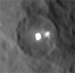
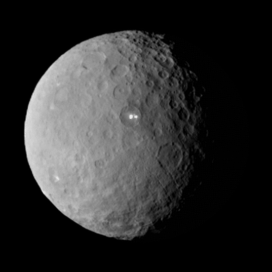
Nice bullseye pattern! If that's an old impact basin, it's diameter is either 380km or 630km, depending on which of two ridges is part of the rim.
The circumstantial evidence for ice volcanoes is growing. There's a diagonal fault line below centre, adjacent to which is an isolated mountain about 20km in diameter and 5km high, that just happens to be one of the bright spots. Then there's the bright spot on the prime meridian that has rays like an impact crater but the broad base of a caldera. It's near the terminator in the last image of the rotation sequence. No wonder the Dawn team is puzzled!
Click to view attachment
Merged maps with Hubble color.
Click to view attachment
One small blank spot near the top right has been filled in with fluff.
Click to view attachment
One small blank spot near the top right has been filled in with fluff.
The cylindrical map is inexplicably low in resolution and doesn't show fault lines well, so I've drawn some on. Notice that one bright spot is adjacent to a fault line and the other (a large isolated mountain) coincides with a junction of two fault lines.
Click to view attachment
Click to view attachment
QUOTE (algorimancer @ Mar 3 2015, 03:27 AM) 
Looking over the 3D views, that big relaxed "sand dollar"-shaped feature seems like the key to much of what we're seeing.
Clearly it is relatively young, based on the low crater count.
Clearly it is relatively young, based on the low crater count.
Keep in mind that the slower the crater relaxation process is, the later the point in time which the crater clock will be reset to. This crater might be very old.
Quite a few hexagonal basins and craters out there - I marked those at firsthand recognizable:
Click to view attachment
There is even a 'bell shaped' structure:
Click to view attachment
Click to view attachment
There is even a 'bell shaped' structure:
Click to view attachment
QUOTE (TritonAntares @ Mar 3 2015, 05:00 AM)
Quite a few hexagonal basins and craters out there...
A google search for "hexagonal crater" led me to the book "Impact Tectonics", which has a lengthy discussion about hexagonal and generally polygonal craters, which are fairly common throughout the solar system. It seems that the key explanation is an impact into previously fractured surface, with the polygonal sides due to either preferential impact excavation along the fracture lines or post-impact slumping of the crater walls away from the fracture lines (I gather it is not completely resolved). At Ceres, we might expect fractures due both to prior fractures and surface expansion as an underlying ocean froze.
QUOTE (John Broughton @ Mar 2 2015, 11:36 PM)
Nice bullseye pattern! If that's an old impact basin, it's diameter is either 380km or 630km, depending on which of two ridges is part of the rim.
The circumstantial evidence for ice volcanoes is growing. There's a diagonal fault line below centre, adjacent to which is an isolated mountain about 20km in diameter and 5km high, that just happens to be one of the bright spots. Then there's the bright spot on the prime meridian that has rays like an impact crater but the broad base of a caldera. It's near the terminator in the last image of the rotation sequence. No wonder the Dawn team is puzzled!
Click to view attachment
The circumstantial evidence for ice volcanoes is growing. There's a diagonal fault line below centre, adjacent to which is an isolated mountain about 20km in diameter and 5km high, that just happens to be one of the bright spots. Then there's the bright spot on the prime meridian that has rays like an impact crater but the broad base of a caldera. It's near the terminator in the last image of the rotation sequence. No wonder the Dawn team is puzzled!
Click to view attachment
we have noticed this one too. several hypotheses are on the table including both impact and non-impact . . .
as has been noted by all so far, the need to get to 1 km resolution or better is true for all structures, including this one to distinguish the features associated with each hypothesis. But it also sobering to recall that there are large scale features on Vesta we still don't understand, like the large topographic scarps near Marcia crater, for example . . .
QUOTE (algorimancer @ Mar 3 2015, 01:46 PM)
A google search for "hexagonal crater" led me to the book "Impact Tectonics", which has a lengthy discussion about hexagonal and generally polygonal craters, which are fairly common throughout the solar system. It seems that the key explanation is an impact into previously fractured surface, with the polygonal sides due to either preferential impact excavation along the fracture lines or post-impact slumping of the crater walls away from the fracture lines (I gather it is not completely resolved). At Ceres, we might expect fractures due both to prior fractures and surface expansion as an underlying ocean froze.
Lucid explanation. These hexagonal craters and basins first remember me of such kind of structures on Iapetus.
There seems to be a lower boundary of this hexagonal crater pattern. A task requiring great diligence to find the smallest hex-impact for sure

Btw. the 'bell shaped' basin in a global view:
Click to view attachment
This is what you get if you extend Gerald's reprojections into the south polar region (to go with the north polar mapping shown earlier).
Phil
Click to view attachment
Phil
Click to view attachment
QUOTE (Phil Stooke @ Mar 3 2015, 04:37 PM)
... and if you add those polar sections to the Dawn map you get this:
Phil
Phil
WOW ! Thanks a lot to our Cartographer-in-Chief & congratulations to him !

Why would an ice volcano be situated right in the middle of an impact crater? I've never heard of that before -- so until more conclusive results are in, I'm assuming it has something to do with the impact.
QUOTE (Astro0 @ Mar 3 2015, 05:55 AM)
For interest, I centred the white spot(s) from the larger rotation animation and doubled the size in this back and forth animation, just to watch the change in lighting. No conclusions to draw from it, but it's certainly going to be interesting to get detailed images later in the mission.
Thanks Astro0 !
I hope they will be able to get good un-saturated images of this bright feature !

QUOTE (Superstring @ Mar 3 2015, 05:20 PM)
Why would an ice volcano be situated right in the middle of an impact crater? I've never heard of that before -- so until more conclusive results are in, I'm assuming it has something to do with the impact.
If the surface is full of craters, where else is a poor ice volcano to set up shop?

(I don' think there are many expecting a volcano though, a small vent (or two) would still be of cryovolcanic origin)
QUOTE
Quite a few hexagonal basins and craters out there...
But quite common. I recall hexagonal crater and lineations first being discussed in Ralph B. Baldwin's The Measure of the Moon and alluded to in his earlier The Face of the Moon.
And, as Algorimancer notes, there are many other studies on hexagonal structures.
--Bill
Merged map based on the 27 RC2 frames of pia18920.gif:
Click to view attachment
Edit: Animation of maps by frame:

(size reduced)
Assumed globes, animated:

(half size)
Click to view attachment
Edit: Animation of maps by frame:
(size reduced)
Assumed globes, animated:
(half size)
It seems with every release we find something odd about the resolution of the images. I've compared the main bright spot image (PIA19185) from the previous release with frame one of the animation in the latest release. They're pretty clearly the same image, as you can see by comparing features near the terminator (that's why I've gamma tweaked these images).
However, the PIA18920 animation frame 1 is stretched vertically relative to PIA19185! For this gif, I've left PIA19185 alone (apart from gamma), but for PIA18920 frame 1 I've rotated 10 degrees, followed by a reduction in size to 90% (horizontally and vertically):
Click to view attachment
Previously we thought PIA19185 was supersampled 2x, so my suspicion is that the new animation frames have been altered. You can see a circular masked region on the new animation frames, with black outside. My guess is there may be some connection: someone tried to mask (I can't imagine why) with a circle and noticed Ceres isn't a sphere, so stretched it!
Anyway, this clearly means that anyone trying to create map projections from the images (Gerald, Phil) has to be careful.
The mask is probably used to mask noise/dark frame outside the shape of Ceres.
Respective shape: I needed to adjust the diameter ratios to 920/975.
Images may be pincushion distorted a bit, but without knowing the position and rotation of the images, that's hard to infere.
Respective shape: I needed to adjust the diameter ratios to 920/975.
Images may be pincushion distorted a bit, but without knowing the position and rotation of the images, that's hard to infere.
The two opnav4 images show the north pole a bit better than before. Here I have added them to the northern hemisphere map.
Phil
Click to view attachment
Phil
Click to view attachment
QUOTE (fredk @ Mar 3 2015, 10:23 AM)
Previously we thought PIA19185 was supersampled 2x, so my suspicion is that the new animation frames have been altered. You can see a circular masked region on the new animation frames, with black outside. My guess is there may be some connection: someone tried to mask (I can't imagine why) with a circle and noticed Ceres isn't a sphere, so stretched it!
Anyway, this clearly means that anyone trying to create map projections from the images (Gerald, Phil) has to be careful.
Anyway, this clearly means that anyone trying to create map projections from the images (Gerald, Phil) has to be careful.
Oh my gosh that explains the weird number of 230% of the original resolution for the vertical dimension. That is awful.
The question is, was the stretching done before or after the rotation?
Edit: after messing with it, it's clear the stretching was done after the rotation.
I tried to match PIA18920 animation frame 1 to PIA19185 with stretching followed by rotation, but that isn't enough to make the two frames match.

QUOTE (John Broughton @ Mar 3 2015, 05:36 AM)
Nice bullseye pattern! If that's an old impact basin, it's diameter is either 380km or 630km, depending on which of two ridges is part of the rim.
The circumstantial evidence for ice volcanoes is growing. There's a diagonal fault line below centre, adjacent to which is an isolated mountain about 20km in diameter and 5km high, that just happens to be one of the bright spots. Then there's the bright spot on the prime meridian that has rays like an impact crater but the broad base of a caldera. It's near the terminator in the last image of the rotation sequence. No wonder the Dawn team is puzzled!
Click to view attachment
The circumstantial evidence for ice volcanoes is growing. There's a diagonal fault line below centre, adjacent to which is an isolated mountain about 20km in diameter and 5km high, that just happens to be one of the bright spots. Then there's the bright spot on the prime meridian that has rays like an impact crater but the broad base of a caldera. It's near the terminator in the last image of the rotation sequence. No wonder the Dawn team is puzzled!
Click to view attachment
Would carbon doxide outgassing from subsurface resevoirs, driven by solar heat, be possible in the Cerean temperature regime. We know (or strongly suspect) that this is the force behind the 'mars siders'...
QUOTE (elakdawalla @ Mar 3 2015, 07:04 PM)
I tried to match PIA18920 animation frame 1 to PIA19185 with stretching followed by rotation, but that isn't enough to make the two frames match.
Agreed, Emily, I also tried that. This makes it look like more was done than just rotation and vertical stretch - some weird geometrical distortion was also done.I wonder if it might be that the two frames are not actually the same, but separated by very close to one Ceres rotation. That might explain some apparent geometrical distortion, but still would not explain the vertical stretch.
QUOTE (Gerald @ Mar 3 2015, 06:33 PM)
The mask is probably used to mask noise/dark frame outside the shape of Ceres.
Respective shape: I needed to adjust the diameter ratios to 920/975.
Images may be pincushion distorted a bit, but without knowing the position and rotation of the images, that's hard to infere.
Respective shape: I needed to adjust the diameter ratios to 920/975.
Images may be pincushion distorted a bit, but without knowing the position and rotation of the images, that's hard to infere.
But the noise is very low, as you can see by comparing masked and unmasked black. And a levels adjustment could have dealt with the small noise level more simply.
As for pincushion distortion, we don't have the full frames, but if, as I'd expect, Ceres is roughly near the centre of the frames, then I'd expect negligible distortion for a 222 pixel diameter region.
Possibly a reprojection from the perspective view of the camera to orthographic for mapping purposes?
Phil
Phil
A better combination of maps than I posted yesterday, now without 'ghost' duplicate features. Again, with Hubble color (also adjusted to align better).
Click to view attachment
This does not include any of the nice polar regions posted today.
Click to view attachment
This does not include any of the nice polar regions posted today.
Are there any released images of the longitudes east of the bright spots? The global cylindrical map (pia18923) does show the area (in RC2 imagery?), but it has been shrunken down to 739x369 pixels for some reason.
Edit: Apparently not.
Edit: Apparently not.
QUOTE (fredk @ Mar 3 2015, 08:26 PM)
Agreed, Emily, I also tried that. This makes it look like more was done than just rotation and vertical stretch - some weird geometrical distortion was also done.
I wonder if it might be that the two frames are not actually the same, but separated by very close to one Ceres rotation. That might explain some apparent geometrical distortion, but still would not explain the vertical stretch.
I wonder if it might be that the two frames are not actually the same, but separated by very close to one Ceres rotation. That might explain some apparent geometrical distortion, but still would not explain the vertical stretch.
After 9 hours the distance of Dawn to Ceres will have changed, such that perspective distortion occurs. I've been considering distance since a while for the mappings, but not yet within one sequence.
QUOTE (Gladstoner @ Mar 3 2015, 08:54 PM)
Are there any released images of the longitudes east of the bright spots?
I'm only aware of OpNav3.
QUOTE (fredk @ Mar 3 2015, 08:26 PM)
As for pincushion distortion, we don't have the full frames, but if, as I'd expect, Ceres is roughly near the centre of the frames, then I'd expect negligible distortion for a 222 pixel diameter region.
Whoknows; they are trying to minimize fuel consumption.
QUOTE (Phil Stooke @ Mar 3 2015, 11:42 AM)
Possibly a reprojection from the perspective view of the camera to orthographic for mapping purposes?
That sounds plausible. Can you tell if the distortions look like what you'd get from a reprojection to orthographic? I can't wrap my brain around it. Comparing the two versions of the image mentioned previously, regions in the equatorial latitudes have expanded vertically from the more raw one to the more-resized one, while polar ones have shrunk.
QUOTE (Gladstoner @ Mar 3 2015, 11:54 AM)
Are there any released images of the longitudes east of the bright spots? The global cylindrical map (pia18923) does show the area (in RC2 imagery?), but it has been shrunken down to 739x369 pixels for some reason.
Well, the original data would've had a disk about 200 pixels tall, so this is still an enlargement.
QUOTE (elakdawalla @ Mar 3 2015, 03:25 PM)
Well, the original data would've had a disk about 200 pixels tall, so this is still an enlargement.
Ok.
So then it seems they didn't include some images in the rotation GIF for some reason.
Between two consecutive RC2 images I get a rotation angle of about 9.3 degrees. Take 9 hours rotation period for Ceres, and a 10 hours observation period, there should have been taken 10/9 * 360°/9.3° + 1 = 44 images, hence 17 images not contained in the 27 images sequence.
... that's work in progress for everyone.
... that's work in progress for everyone.
QUOTE (elakdawalla @ Mar 3 2015, 10:25 PM)
That sounds plausible. Can you tell if the distortions look like what you'd get from a reprojection to orthographic? I can't wrap my brain around it. Comparing the two versions of the image mentioned previously, regions in the equatorial latitudes have expanded vertically from the more raw one to the more-resized one, while polar ones have shrunk.
I'd expect pretty small differences between a perspective view at 46 000 km vs orthographic, for a 1000 km body. But someone like Gerald could render the two with coordinate lines to see what the difference really is.
QUOTE (Gerald @ Mar 3 2015, 04:32 PM)
Between two consecutive RC2 images I get a rotation angle of about 9.3 degrees. Take 9 hours rotation period for Ceres, and a 10 hours observation period, there should have been taken 10/9 * 360°/9.3° + 1 = 44 images, hence 17 images not contained in the 27 images sequence.
... that's work in progress for everyone.
... that's work in progress for everyone.
Indeed. I'm always itching for more images, especially of the area circled here:
Click to view attachment
I know I'm not alone.
QUOTE (Gerald @ Mar 3 2015, 10:32 PM)
Between two consecutive RC2 images I get a rotation angle of about 9.3 degrees. Take 9 hours rotation period for Ceres, and a 10 hours observation period, there should have been taken 10/9 * 360°/9.3° + 1 = 44 images, hence 17 images not contained in the 27 images sequence.
... that's work in progress for everyone.
... that's work in progress for everyone.
Its noticeable that the "Great White Spot" feature suddenly appears half way through the rotation. Initially I thought this indicated it was purely a reflected light feature, now one has to think, maybe not. Has anyone managed to spot the crater without the bright spots being visible? The dislocation in the animation makes it difficult to track back.
QUOTE (Sherbert @ Mar 3 2015, 06:05 PM)
Its noticeable that the "Great White Spot" feature suddenly appears half way through the rotation. Initially I thought this indicated it was purely a reflected light feature, now one has to think, maybe not. Has anyone managed to spot the crater without the bright spots being visible? The dislocation in the animation makes it difficult to track back.
I first thought that, too, but after I watched many times, it looks like the rotation movie isn't "continuous." It appears to me as if as if they spliced together two sets of frames but didn't leave a "blank spot" in the movie or something.
QUOTE (fredk @ Mar 3 2015, 11:46 PM)
I'd expect pretty small differences between a perspective view at 46 000 km vs orthographic, for a 1000 km body. But someone like Gerald could render the two with coordinate lines to see what the difference really is.
That's what I could do in the short run: The effect of a distance assumption of 46,000 km vs. 1,000,000 km on the map projection:

I'd say it's going to become relevant at the current image resolution.
Edit: Effect on the grid:

Edit: Ok, and here the simulated views at distances of 46,000 km and 1,000,000 km:

Nice demonstration of the fact that my explanation can't be correct!
Phil
Phil
QUOTE (marsbug @ Mar 3 2015, 08:23 PM)
Would carbon doxide outgassing from subsurface resevoirs, driven by solar heat, be possible in the Cerean temperature regime. We know (or strongly suspect) that this is the force behind the 'mars siders'...
The temperature range is just right for carbon dioxide, but on Mars there's an atmosphere, while thin still, provide enough gas to let the planet have a CO2 cycle with refreezing and thawing. I find it unlikely since there's no atmosphere at Ceres (though it might have an homeopathically thin exosphere like our Luna).
Any CO2 that once were buried during the formation of Ceres near the surface could have been depleted by now.
QUOTE (marsbug @ Mar 3 2015, 08:23 PM)
Would carbon doxide outgassing from subsurface resevoirs, driven by solar heat, be possible in the Cerean temperature regime. We know (or strongly suspect) that this is the force behind the 'mars siders'...
I'm no geochemist but I'd assume carbon dioxide was driven off when Ceres differentiated and formed the ~100km-deep ocean that theoretical studies predict is there. Anyway, doesn't CO2 sublimate at a lower temperature than water ice, and leave no trace when it's gone.
The ocean surface would have froze over and then accumulated a rocky crust. The ice shell could be over 20km in depth by now, judging by the amount of topography it supports. By the way, I calculated the amount of salt deposited over the age of the Solar System if the driving force was the gradual freezing (and expansion) of the underside of the ice shell. Interestingly, there's enough to build many 5km-tall volcanic cones, without requiring any heat sources.
I have the impression that "something" has formed deposits in the south polar regions (less clear in the north). Color would be really helpful in guessing what this might be. CO2 occurred to me (thinking of Mars as an example), though it could simply be water ice with a different texture, perhaps deposited near the poles following sublimation near the equator. Could be something else -- perhaps simply dust?
Here's a good example, outlined in red. The albedo of this region remains lower than in adjacent regions independently of variations in lighting as Ceres rotates. I have doubled the image size, with lanczos3 smoothing.
Click to view attachment
EDIT: Removed suggestion it could be methane, after reviewing phase curve. CO2 ice remains feasible if the temperature is around 140K or below.
QUOTE (jgoldader @ Mar 4 2015, 12:13 AM)
after I watched many times, it looks like the rotation movie isn't "continuous." It appears to me as if as if they spliced together two sets of frames but didn't leave a "blank spot" in the movie or something.
With gifs like this it's easy to extract the individual frames and flip through them at your leisure. This makes it easy to see that there's a gap in the animation. On windows, you can use irfanview, eg, and go to options -> extract all frames.
QUOTE (fredk @ Mar 4 2015, 09:29 AM)
... there's a gap in the animation....
I know from my experience creating the stereo image pairs that there is a gap between the last image and the first in the sequence.
QUOTE (TheAnt @ Mar 4 2015, 12:29 PM)
The temperature range is just right for carbon dioxide, but on Mars there's an atmosphere, while thin still, provide enough gas to let the planet have a CO2 cycle with refreezing and thawing. I find it unlikely since there's no atmosphere at Ceres (though it might have an homeopathically thin exosphere like our Luna).
Any CO2 that once were buried during the formation of Ceres near the surface could have been depleted by now.
Any CO2 that once were buried during the formation of Ceres near the surface could have been depleted by now.
Thanks (and to john boughton)! The other thought I had was that the cetral peak had collapsed off to one side in a massive landslip that exposed fresh ice and piled some against the crater floor.
Ceres maps normalized to about the same local solar time, animated in 5-degree steps (corresponding to 20 "Ceres minutes"),
based on the 27 RC2 frames of pia18920.gif:

Light curves are smoothed/interpolated by Gauss curve of standard deviation 9.3 degrees.
based on the 27 RC2 frames of pia18920.gif:
Light curves are smoothed/interpolated by Gauss curve of standard deviation 9.3 degrees.
QUOTE (algorimancer @ Mar 4 2015, 01:47 PM)
I have the impression that "something" has formed deposits in the south polar regions (less clear in the north). Color would be really helpful in guessing what this might be. CO2 occurred to me (thinking of Mars as an example), though it could simply be water ice with a different texture, perhaps deposited near the poles following sublimation near the equator. Could be something else -- perhaps simply dust?
Here's a good example, outlined in red. The albedo of this region remains lower than in adjacent regions independently of variations in lighting as Ceres rotates. I have doubled the image size, with lanczos3 smoothing.
Click to view attachment
Here's a good example, outlined in red. The albedo of this region remains lower than in adjacent regions independently of variations in lighting as Ceres rotates. I have doubled the image size, with lanczos3 smoothing.
Click to view attachment
The Northern edge of the area you have highlighted looks to be a boundary marked by a change in elevation resulting from a resurfacing event. The lighter material to the North having flowed over an earlier resurfacing event. Much of the dark colour of Ceres can be attributable to dust and dust catalysed photochemical reactions of the volatiles slowly sublimating through the dust to form complex organics. The longer a surface has been exposed the darker its appearance. If there was once, or even still is, a subsurface liquid ocean, it would remain for longest in the equatorial regions and any resurfacing events or convection mixing of the sub-surface ices would be more recent than nearer the poles. Salts dissolved in the liquid/ice and left behind by sublimation, would also one suspects contribute to a lighter surface colour. One would expect therefore the surface in the polar regions to appear darker.
The Hubble colours suggest the equatorial regions are a sort of orange/red colour normally associated with Thollins, but the evidence from the moons of Jupiter, Saturn and Uranus and most recently from comet 67P, is that long term exposure to higher levels of UV radiation from the Sun gradually turns these organics a very dark brown colour. Kuiper belt objects such as Pluto still retain much of the red colour suggesting either fresher surfaces or insufficient radiation intensity to completely "cook" the organics. Titan with its suggested liquid/gas Methane cycle, constantly refreshes the volatiles available for new Thollin formation, hence the continuing orange haze in its atmosphere. Europa where surface recycling is thought to be a lot slower and longer process than on Enceladus, there is time for significant amounts of coloured organics to build up on the surface, concentrated near the fractures where volatiles from below have reached the surface probably dissolved in liquid water. All this might suggest that through some process, probably convection in the ice layer, the surface in the coloured equatorial and mid-lattitude regions of Ceres, is slowly being recycled and there may still be sub-surface seas rather than a global ocean.
The big caveat to that is the way the Hubble "colours" were attributed to Ceres, they are not true colours and some of the above speculation could be proved completely wrong. Dawn is able to take true colour images when closer, so we will have to wait and see I suppose.
QUOTE (Sherbert @ Mar 4 2015, 01:56 PM)
...dark colour of Ceres can be attributable to dust and dust catalysed photochemical reactions of the volatiles slowly sublimating through the dust to form complex organics...
That was a great post, and clarifies many things.
I decided to play with Gerald's light curves animation. Focusing on the pixels with data for all frames between frames 17 to 28, I determined the slope of the light curve over that range for each pixel, then did a color projection of that slope onto the red and green channels. Here's the result, which should provide some sense of different surface properties per the light curve slope. Gerald, I'm sure you could do something rather more sophisticated since you have more complete data (and rather more expertise), but this is a start.
Click to view attachment
Great first step in analysing the light curves!
Slope of the light curves may be correlated to albedo. To separate slope and albedo of the terrain properly, I guess two or three parameters of the light curve need to be inferred. I can't yet predict how successful this will be, but I'm intending to work on it the next days.
Nice to see others working on the analysis, too!
Those 'twin craters' that were very visible in the first OpNav sessions still look pretty intriguing. The biggest of them (the one to the right) is not properly within the field of view for any of the 27 RC2 pictures that have been released (and they are both inconveniently low on Ceres' sphere from Dawn's RC2 vantage point, obviously).
In the map rotation movie, the biggest one still looks like a double crater, and there does appear to be some sort of valleys in the area of the original linear features (visible to the left and to the bottom in frame 27).
In the event that the brightest spots turn out to be just two small impacts, I think this part of Ceres might just be the most exciting one. Those craters (if that's what they actually are) look pretty strange, and the grooves are right above them; apparently extending all the way down to the biggest crater.

A big area above those craters is also very smooth (as can be verified as it moves into the nightside), and it also contains the chevron-like feature I posted earlier. Something is going on there (or rather: has gone on).
In the map rotation movie, the biggest one still looks like a double crater, and there does appear to be some sort of valleys in the area of the original linear features (visible to the left and to the bottom in frame 27).
In the event that the brightest spots turn out to be just two small impacts, I think this part of Ceres might just be the most exciting one. Those craters (if that's what they actually are) look pretty strange, and the grooves are right above them; apparently extending all the way down to the biggest crater.
A big area above those craters is also very smooth (as can be verified as it moves into the nightside), and it also contains the chevron-like feature I posted earlier. Something is going on there (or rather: has gone on).
This is a "lo-fi" version of our main content. To view the full version with more information, formatting and images, please click here.