Is the position of back-seat driver taken? I might have to check the map again, but...
Phil
Full Version: Spring at Cape York

Likewise!
Phil
Click to view attachment
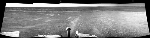
This also adds to my 'backseat driver' post just above. This presentation of the pan shows what we are looking at - the hills referred to are indeed the north rim of Endeavour. We can also see the central mound on Endeavour as a dark ridge. Cape Tribulation and Nobby's Head are hidden behind Morris Hill, the top of Cape York.
Phil
Click to view attachment
This also adds to my 'backseat driver' post just above. This presentation of the pan shows what we are looking at - the hills referred to are indeed the north rim of Endeavour. We can also see the central mound on Endeavour as a dark ridge. Cape Tribulation and Nobby's Head are hidden behind Morris Hill, the top of Cape York.
Stu, are you sure? The tracks left from Sol 2963, which are clearly visible in the panorama, are in a direction of about 200 degrees. I think that what you indicated as Eastern Far Side Hills is in fact Cape Tribulation.
Paolo
Paolo
200 clockwise from north, Paolo? - as in my circular pan above? I'm sorry but I think you are turned around a bit.
Phil
Phil
Very sure Paolo, yes. The Eastern Hills are dominated by that large, oval-shaped (STILL un-named!!!) crater, which faces the western side of Endeavour. Oppy has been looking at - and watched over by - that crater ever since she arrived at Cape York. Tribulation is on this same side as Cape York, south of where we are now, but hidden at the moment by the lie of the land.
QUOTE (Phil Stooke @ May 26 2012, 06:49 AM) 
200 clockwise from north
200 degrees from north for the rover tracks is correct; it's just that Cape York is blocking the view of the rim past about 165 degrees from north. I think maybe the most southern part of the west rim is just visible, but I don't think Tribulation is.
Paolo's comments suggest he was thinking of 200 degrees from west. But don't worry, folks, no harm done. It's not like we're heading back to Victoria crater by mistake! (or are we?)
Phil
Phil
I am 100% sure that the tracks are 200 degrees compass heading (20 degrees West of South) but I think you are right. NAVCAM mosaics are spaced 36 deg so you are right! I apologize.
Paolo
Paolo
Don't apologise Paolo, we're all thrilled you're here. And if you want to drive over *there* feel free, I'd love a look at those hills close-up! 
It's definitely easy to loose track of azimuth in a navcam pan presented at such a small scale!
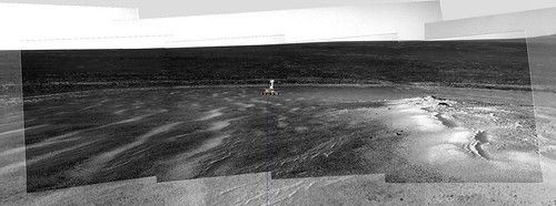
Here's a comparison with a pan from Greeley so we can see how Tribulation is just barely obstructed by Morris Hill now:
Click to view attachment
(Both pans from mhoward.)
Here's a comparison with a pan from Greeley so we can see how Tribulation is just barely obstructed by Morris Hill now:
Click to view attachment
(Both pans from mhoward.)
Great idea fredk; I wish I'd thought of that.
I'd be utterly confused as to rover positioning without the ongoing work by UMSF image wizards, so cheers to all, looking forward to the upcoming drives 
UMSF PanCam Experts are Awesome!!
Some serious driving is in the works. By noon (PDT) on Sunday we should know if we got it all in. Rolling, rolling, rolling... 
Paolo
Paolo
Roll on, Paolo! (Great to see you back on UMSF, BTW, hope all is well!)
(Great to see you back on UMSF, BTW, hope all is well!)
QUOTE (nprev @ May 26 2012, 03:45 PM)
Roll on, Paolo! (Great to see you back on UMSF, BTW, hope all is well!)
(Great to see you back on UMSF, BTW, hope all is well!)I'm all right but a bit too busy with MSL to enjoy driving Oppy. My next shift is on June 6th!
Paolo
Wow, found a vein already?
Phil
http://qt.exploratorium.edu/mars/opportuni...LMP1212R0M1.JPG
They're all over the place:
http://qt.exploratorium.edu/mars/opportuni...LMP0615R0M1.JPG
Phil
http://qt.exploratorium.edu/mars/opportuni...LMP1212R0M1.JPG
They're all over the place:
http://qt.exploratorium.edu/mars/opportuni...LMP0615R0M1.JPG
QUOTE (Phil Stooke @ May 27 2012, 09:19 PM)
Wow, found a vein already?
<...>
They're all over the place:
<...>
They're all over the place:
That's what I thought too.
QUOTE (RoverDriver @ May 27 2012, 01:08 AM)
Some serious driving is in the works. By noon (PDT) on Sunday we should know if we got it all in. Rolling, rolling, rolling...
Paolo
Paolo
Where's the "Like" button?

I measured about 50m NNE and it's confirmed by the pancam database. Route map update in a minute.
Sol 2965 was only 50.5 meters, it was cut short because we hit the lower limit for northerly tilt. This was one of the expected possible result, so today we have nominal F/R HAZ.
Paolo
Paolo
50 meters sounds pretty good to me! Azimuth of the drive was about 18º from north according to the metadata.
MERB2965Position on Flickr
MERB2965Position on Flickr
Thanks for the map update, Tesh. I was pointed completely upside down with my previous question. I am not unfamiliar with such revelations here on our home planet
QUOTE (brellis @ May 27 2012, 01:33 PM)
Thanks for the map update, Tesh. I was pointed completely upside down with my previous question. I am not unfamiliar with such revelations here on our home planet
I second that. You have no idea how many times I refer to the USMF maps on top of the ones we have, including last Wednesday! Thanks!
Paolo
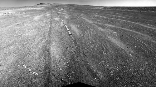
I love these shots where you can see Oppy's tracks tracing out the contours of the landscape, that let you imagine how she bounced up and down as she drove in and out of hollows, over ripples etc...
Click to view attachment
Click to view attachment
When I assembled the p1994 I did use the accelerometer telemetry to generate the associated sound. Much like for a phonographic recording, I used the Z value from the accels as the difference between the Left and Right side and the RMS of the X and Y values as the sum of the Left and Right to compute the two channels, I put everything into a WAV file and use LAME to convert it to mp3.
If we start driving on something interesting I will assemble more of these "sounds from mars".
Paolo
If we start driving on something interesting I will assemble more of these "sounds from mars".
Paolo
QUOTE (RoverDriver @ May 29 2012, 04:14 PM)
If we start driving on something interesting I will assemble more of these "sounds from mars".
Paolo
Paolo
New favorite anticipated Mars info
Wow, turn away for a few days and miss something! Nice roiling rocks in view, just off the Cape.
Click to view attachment
And we're ever so closer to the whale spout, due east. That is indeed an interesting feature.
Click to view attachment
And we're ever so closer to the whale spout, due east. That is indeed an interesting feature.
Thought I'd give this a try with my meager Photoshop skills. For what it's worth, the micros from sol 2960 again as 3D mosaic:
Click to view attachment
Looks like the micro camera shot the left side from different angle than the right, as those planes are not parallel.
We love you, Oppy! What an awesome little robot.
Click to view attachment
Looks like the micro camera shot the left side from different angle than the right, as those planes are not parallel.
We love you, Oppy! What an awesome little robot.
QUOTE (walfy @ May 30 2012, 10:35 PM)
...
Looks like the micro camera shot the left side from different angle than the right, as those planes are not parallel.
...
Looks like the micro camera shot the left side from different angle than the right, as those planes are not parallel.
...
That is correct. Since Oppy's Az actuator no longer works the way we shoot 2x2 (or 2xn in general) is to turn the turret 5 deg to the left then turn 5 deg to the right from the center plane where the IDD can move. The two stacks (see my interview with Stu where I explain what an MI stack is) are shot with the boresight a total of 10 deg apart which make the two frames about 25mm apart. The two stacks are not parallel to each other but the resulting geometric distortion is small enough that can be removed on the ground. In fact the major issue is not stitching two stacks together but the fact that the within a single MI stack each frame is centered in a slightly different position which makes certain surfaces quite difficult to image (Winter haven MI mosaic is one good example).
Paolo

Sol 2967 Pancam foreground stereo pair
A sprinkle of magic dust and mhoward's pan is turned into this:
Click to view attachment
Click to view attachment
Phil
Click to view attachment
Click to view attachment
Phil
QUOTE (Phil Stooke @ May 31 2012, 06:37 PM)
A sprinkle of magic dust and mhoward's pan is turned into this: Phil
Thanks a lot Phil for those nice views !
By the way, see how "crystal clear" is the horizon now ! I hope they will do soon an horizon panorama with the L7 filter...
Click to view attachment
Enjoy
Drive direction on sol 2969 was roughly azimuth 40º
QUOTE (vikingmars @ May 31 2012, 11:35 PM)
By the way, see how "crystal clear" is the horizon now ! I hope they will do soon an horizon panorama with the L7 filter...
Exactly! The Oppy weather site says tau is extremely low now. Looking at the curves from previous years, we can expect the air to start loosing its transparency soon, so enjoy it while we can...
QUOTE (walfy @ May 30 2012, 11:35 PM)
For what it's worth, the micros from sol 2960 again as 3D mosaic:
http://www.unmannedspaceflight.com/index.p...st&id=26866
http://www.unmannedspaceflight.com/index.p...st&id=26866
Whatever that is, it's really soft. It appears the sides of the RAT hole just crumbled into the center after it was removed. Now what about that vertical impression on the right? Was that something on the IDD? or is it a natural feature?
This is in the rover tracks, it's a wheel impression.
Phil
Phil
Looks like a short drive back south on 2971 - perhaps to check whether this gypsum vein is wide enough for IDD work?
http://qt.exploratorium.edu/mars/opportuni...0M1.JPG?sol2971
http://qt.exploratorium.edu/mars/opportuni...0M1.JPG?sol2971
Yep, that's what we are trying to do. Possibly we will need one more bump before IDD work can begin. That's what you get with a 4 DOF (degrees of freedom) arm.
Paolo
Paolo
The images are still on the queue but I presume the vein is what has been labeled Monte Cristo; an island with a massive hidden treasure (from the novel).
02971::p2363::30::40::40::0::0::2::82::pancam_Monte_Cristo_3x1_L234567Rall
02971::p2363::30::40::40::0::0::2::82::pancam_Monte_Cristo_3x1_L234567Rall
Last month's report by Salley Rayl is available here (*): http://www.planetary.org/blogs/guest-blogs...ion-rovers.html.
Some tidbits about the vein we drove over this weekend.
And about phyllosilicates:
(*) Couldn't find a permalink.
Some tidbits about the vein we drove over this weekend.
QUOTE
Opportunity closed in on a longer vein earlier this week and there are plans for the rover to bump itself into a position this weekend to look at it up close, if the scientists decide it's worthy. "We are planning a small bump to try to get one of the veins into the IDD work volume," expounded Stroupe. "We're also going to take some color pictures of it. On Monday, we'll decide whether to go ahead and use the IDD or drive to another nearby one."
And about phyllosilicates:
QUOTE
There is little doubt that Opportunity will make it to one of the phylliosilicate-rich areas along Endeavour's rim, but positively identifying clay minerals will be something of a challenge, considering the rover's two specially designed mineral detectors are no longer working. "It will be harder without the Mössbauer and the Mini-TES, but there are things we'll see in the APXS data if there is a high enough concentration of phyllosilicates," assured Squyres.
(*) Couldn't find a permalink.
A question for Paolo, out of curiosity: I notice you've been taking some overlapping Pancam images of the veins recently. For example, the '3x1' Pancam mosaic of Monte Cristo actually has four camera pointings, the center two of which overlap at a slight offset. Is that about some different way of obtaining stereo, or what's up with that?
^ I thought it had to do with dust on the camera.
QUOTE (mhoward @ Jun 3 2012, 10:57 AM)
A question for Paolo, out of curiosity: I notice you've been taking some overlapping Pancam images of the veins recently. For example, the '3x1' Pancam mosaic of Monte Cristo actually has four camera pointings, the center two of which overlap at a slight offset. Is that about some different way of obtaining stereo, or what's up with that?
I have not been on shift lately but the PANCAMs are now quite dusty and IIRC we use only about 10 degrees of horizontal field of view for critical observations. I could well be mistaken tho. I will ask around and let you know.
Paolo
This is a "lo-fi" version of our main content. To view the full version with more information, formatting and images, please click here.