Looks like it's time for a new thread! On to Santa Maria!
Phil
Full Version: On to Santa Maria!
Done. 
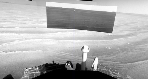
The 2405 hazcams are down: it looks like we've made it to the flat patch:
http://qt.exploratorium.edu/mars/opportuni...0M1.JPG?sol2405
As others have pointed out, this isn't the end of the ripples, but it does give us our first taste of the tarmac surface ahead.
http://qt.exploratorium.edu/mars/opportuni...0M1.JPG?sol2405
As others have pointed out, this isn't the end of the ripples, but it does give us our first taste of the tarmac surface ahead.
Nav/Pancam are expected to be shot and downlinked tomorrow and I expect to see very flat surroundings, at least if I take the HiRISE view as a reference.
Click to view attachment
Click to view attachment
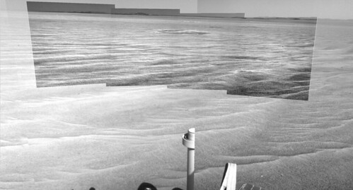
Holy smokes! Flatness!
Very exciting! And these are the images from yestersol (2404) - as Tesh says, 2405's Navcam/Pancam still to come.

And the reason why they are expected tomorrow and not today can be clearly seen on mhoward's mosaic. The rover's autonomous attitude knowledge has drifted a lot so it's time to recalculate it again. The mosaics will be shot after that.
QUOTE (Tesheiner @ Oct 30 2010, 10:49 AM) 
The rover's autonomous attitude knowledge has drifted a lot so it's time to recalculate it again.
Seems like it drifts more than it's corrected these days. But maybe that's just because they're moving quickly; I'm okay with that.

Here is the full resolution HiRISE image from here to Santa Maria with my ripple map colour overlay showing all the features we have to encounter. It looks like the very flattest bit (greenest on my map) is just ahead. Lots of the parking lot intact has very small ripples, craters, Anatolia like features, more bedrock, etc. Doesn't look like we'll get bored!

Click image for size options.
James
Click image for size options.
James
QUOTE (jamescanvin @ Oct 30 2010, 09:59 PM)
Doesn't look like we'll get bored!
I hope the nav computer of oppy won't get bored. If the environment doesn't have good identifyable landmarks the computer cannot calculate from the pictures, how far the rover has driven.
We had this problem in the near of Victoria.
QUOTE (Phil Stooke @ Oct 29 2010, 03:59 PM)
The distant dark spot beyond 'A' is visible in the Post #452 image above. (The 124 degree heading)
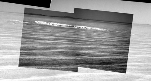
Agreed. Here's a map showing a few more identifications farther afield, with Phil's 2402 stitch-n-stretch:
Click to view attachmentClick to view attachment
Crater G now appears to be the farthest identifiable feature on the plains - it's about a third of the way to Cape York.
My impression is that we can basically see all of the plains now, up to the near rim of Endeavour. In fact, as we drop down towards Endeavour, the view of the plains may become less impressive. We may now be at the "HOAV" point. This would be a great spot for a superres Endeavour pan...
I think you're right, Fred - this may be the optimum shot... until... wow, just wait until we get to that distant rise and finally look down into Endeavour! OK, let's all shout "super-res" and see if anyone hears us.
Phil
Phil
QUOTE (MoreInput @ Oct 31 2010, 06:42 AM)
If the environment doesn't have good identifyable landmarks the computer cannot calculate from the pictures, how far the rover has driven.
We had this problem in the near of Victoria.
We had this problem in the near of Victoria.
<crazy> maybe now is the time to start scheduling super-long blind drives </crazy>
Updated my blog with some pics showing how the ground beneath Oppy's wheels has changed dramatically...
http://roadtoendeavour.wordpress.com/2010/...py-on-the-flats
(and thanks to fredk for letting me use his brilliant pics, too)
http://roadtoendeavour.wordpress.com/2010/...py-on-the-flats
(and thanks to fredk for letting me use his brilliant pics, too)
Great articles, as usual, Stu.
Just a correction to the second picture, that one with the distances to all little craters up to the "Waypoint": it's about 270m (and not 1.7km) to that crater.
Just a correction to the second picture, that one with the distances to all little craters up to the "Waypoint": it's about 270m (and not 1.7km) to that crater.
QUOTE (Tesheiner @ Oct 31 2010, 11:18 AM)
Great articles, as usual, Stu.
Just a correction to the second picture, that one with the distances to all little craters up to the "Waypoint": it's about 270m (and not 1.7km) to that crater.
Just a correction to the second picture, that one with the distances to all little craters up to the "Waypoint": it's about 270m (and not 1.7km) to that crater.
Ah *****! Corrected, thanks. That's what you get for getting up at 6am to catch up on stuff before going to work...
I know we won't be approaching Santa Maria from the south, but I'm struck by some features there... are the "domes" filled-in, older craters? Wind-carved features? They just caught my eye, that's all...
Click to view attachment
QUOTE (fredk @ Oct 30 2010, 09:44 PM)
My impression is that we can basically see all of the plains now, up to the near rim of Endeavour.
fredk, looking at that second image of yours...and to think that Endeavour was just a crazy thought some time ago still boggles my mind...
Just for fun, a pic showing the relative sizes of Santa Maria and Victoria Crater...
Click to view attachment
Click to view attachment
Nice comparison Stu. So Santa Maria is kind of Duck Bay sized, that helps me visualise it a lot, thanks.
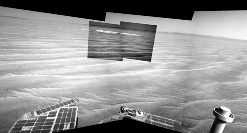
The new navcams and pancams are down. Here's a stereo view showing a number of the craters ahead on the plains. In order of distance, the closest is what I labelled D (the "doublet"), then C, then A (the "waypoint"), and finally much farther away is G. Immediately past D is the ultra-flat stretch.
Click to view attachment
(Oh yeah, and even farther away is a little crater known as Endeavour...)
Click to view attachment
(Oh yeah, and even farther away is a little crater known as Endeavour...)
Sol 2406
Nice graphic, Stu. How would you feel about tossing Endurance in there for comparison?
Interesting comparison, it looks like santa maria crater is large enough/old enough for the 'capes' and 'bays' formations to form. If that were the case for santa maria then it would indicate that the original crater was smaller than the size we see now.
It would be really interesting to see all the craters above the size of say eagle crater size in Oppys vicinity/on meridiani planum, against each other, a bit like Emily's asteroid montage. It would even be neat to keep the positional relationship to see morphological differences in cratering relating to changes in the plains in which they are punched.
if there is a size correlations with bay formation/depth that would be interesting to see. It might also give some clues as to the erosion rate as larger craters would be expected to be older.
QUOTE (Stu @ Oct 31 2010, 09:24 AM)
(and thanks to fredk for letting me use his brilliant pics, too)
Actually the fabulous stretched pan was from Phil - I only added the labels.
QUOTE (fredk @ Oct 31 2010, 07:14 PM)
Actually the fabulous stretched pan was from Phil - I only added the labels.
sorry Phil! Thanks to everyone who lets me use their pix on my blog. Much appreciated.
Might try to make an 'all craters' montage, when I'm not so busy. Maybe Christmas. 2030!
Here it is!
I put famous craters in one picture, grabbed from Google Earth (also grabbed the strange color of endurance). It roughly the same scale, but not really exact.
The point inside the eagle crater is the lander. The rovers are about the same size (3-4 pixels).
I put also the next waypoints to the picture: Santa Maria and Cape York. Interesting: Cape York could fit into Victoria!
Santa Maria crater is a little smaller than endurance, but Bonneville, visited by Spirit, is larger.
The Home Plate, well visited by Spirit, is just as big as Santa Maria.
Thanks MoreInput!
Funny, I thought Cape York was much much bigger...
Funny, I thought Cape York was much much bigger...
QUOTE (Oersted @ Oct 31 2010, 04:01 PM)
Funny, I thought Cape York was much much bigger...
Here's Cape York (circled).
Click to view attachment
http://marsrover.nasa.gov/gallery/press/op.../20100629a.html
Another really fascinating monthly report by A.J.S. Ryal (with help from Stu and Tesh amongst others) has just been released on The Planetary Society website for October, 2010.
Others will be able to post a link and give a far better synopsis than I but it really does provide a lot of detailed information for the MER fan and scientist alike!
Basically, the excitement level with both rovers is growing - Spirit in anticipation of her regaining contact, Opportunity with Santa Maria and the continuation of the journey to Endeavour.
Thanks again to all those who keep us so well informed and up to date with these missions.
Neil
Here's our first navcam view of the new terrain:
http://qt.exploratorium.edu/mars/opportuni...0M1.JPG?sol2407
http://qt.exploratorium.edu/mars/opportuni...0M1.JPG?sol2407
Special Agent Stooke reporting from Cape Canaveral - this new terrain looks just like the old familiar terrain outside Eagle crater. Presumably the small ripples will provide enough detail for the auto-image-matching software. Looking forward to some lengthy drives.
Phil
Phil
From the Cambridge Bay to the "parking lot" thread:
Perhaps an even better name: from the Planetary Society October MER update (paragraph 16).
"...Opportunity paused this weekend to look out on the sandflat, as Arvidson calls it..."
And we all know what happens on sandflats.
Click to view attachment
QUOTE (fredk @ Oct 28 2010, 11:20 AM)
Edit: Btw, I still prefer "tarmac" to "parking lot", since you either park or drive very slowly in a parking lot, but you move quickly across the tarmac!
Perhaps an even better name: from the Planetary Society October MER update (paragraph 16).
"...Opportunity paused this weekend to look out on the sandflat, as Arvidson calls it..."
And we all know what happens on sandflats.
Click to view attachment
Here's a question for the impact geology experts out there. When we're looking at the rim of Endeavor (like Cape York in MoreInput's great montage on the prior page), are we looking at an uplifted geological section or an inverted geological section? Or perhaps a little of both?
Here's a comment twitted by Scott about the upcoming drive (on sol 2408 I presume):
Today's focus: drive-by shootings. Driving by several craters, imaging them as we pass. Probably gonna image three or four craters today.
Today's focus: drive-by shootings. Driving by several craters, imaging them as we pass. Probably gonna image three or four craters today.
QUOTE (algorimancer @ Nov 1 2010, 04:16 PM)
... When we're looking at the rim of Endeavor ... are we looking at an uplifted geological section or an inverted geological section?
In the western rim of Endeavour the geological section appears to be uplifted but not overturned. Where layers in the rock can be discerned, they appear to be dipping away from the center of the crater. It is not so apparent at Cape York, but evidence can be found in segments of the rim south of Cape York. Take a look at the paper about Endeavour's phyllosilicates that I mentioned a few months ago. Figure 1d is a schematic cross section through the rim. Also see figure 3b. It is an anaglyph of a part of the rim clearly showing beds of rock dipping away from the crater.
Of course such dips do not conclusively prove that the section is not overturned. It could be overturned greater than 180 degrees, but that would be pretty unusual in this setting.
QUOTE (Oersted @ Oct 31 2010, 10:01 PM)
Thanks MoreInput!
Funny, I thought Cape York was much much bigger...
Funny, I thought Cape York was much much bigger...
Nice comparison from MoreInput!
I was not too far there regarding Cape York size. I was surprised too to see how "small" it is. See post # 450 here : http://www.unmannedspaceflight.com/index.p...6438&st=450
QUOTE (CosmicRocker @ Nov 2 2010, 01:53 AM)
...the geological section appears to be uplifted but not overturned...
Thanks, that should help a bit with interpretation when we get there.
Update on the planned drive:
QUOTE
DSN problems kept us from uplinking Monday's crater-hopping drive. They're redoing part of it today (less drive time, so cut it short).
I had cobbled this togeher before MoreInput's excellent comparisons were posted, but thought some of you might like to see these three places side-by-side...
Santa Maria, Victoria and Cape York...
Click to view attachment
Santa Maria, Victoria and Cape York...
Click to view attachment
QUOTE (fredk @ Oct 30 2010, 10:44 PM)
My impression is that we can basically see all of the plains now, up to the near rim of Endeavour. In fact, as we drop down towards Endeavour, the view of the plains may become less impressive. We may now be at the "HOAV" point. This would be a great spot for a superres Endeavour pan...
Click to view attachment
What is great in your "Philovision" pic is that with (i) facing now a smooth descending slope and (ii) roughly 10 km more to go before reaching our Cape York target, the lowest parts of the features of Endeavour crater are still below the local Martian horizon (located about 4 km away) : a fascinating perspective ! Thanks to your processing, we have a good visual example showing the curvature of Mars...
It's hard to say for sure, but I'd think we're seeing more the curvature of the surface as it drops into Endeavour than the curvature of Mars. Judging from the contour maps we've seen (low resolution), it looks like the surface doesn't continue flat up to the rim, instead it curves more gradually downwards. And so Cape York seems to be somewhat below the level of the plains.
In this 2409 navcam view:
http://qt.exploratorium.edu/mars/opportuni...0M1.JPG?sol2409
we seem to be sitting very close to the "doublet" crater. We can only see a part of one of the pair on the far right. I believe that's C and B on the left of the frame.
This is about as flat as it gets:
http://qt.exploratorium.edu/mars/opportuni...0M1.JPG?sol2409
The way the ground must curve on the way to Cape York (as you say, Fred) we'll get some nice views of it during the final approach.
Phil
Phil
QUOTE (fredk @ Nov 3 2010, 03:10 PM)
In this 2409 navcam view:
http://qt.exploratorium.edu/mars/opportuni...0M1.JPG?sol2409
we seem to be sitting very close to the "doublet" crater. We can only see a part of one of the pair on the far right. I believe that's C and B on the left of the
http://qt.exploratorium.edu/mars/opportuni...0M1.JPG?sol2409
we seem to be sitting very close to the "doublet" crater. We can only see a part of one of the pair on the far right. I believe that's C and B on the left of the
Agree. BTW, the double-crater was named "Paramore" and the next one will probably be "golden hind".
02408::p1871::01::6::0::0::6::0::12::Navcam_3x1_Paramore_3bpp
02408::p1872::00::6::0::0::6::0::12::Navcam_3x1_Golden_Hind_3bpp
...
02409::p1871::01::6::0::0::6::0::12::Navcam_3x1_Paramore_3bpp
Interesting detail on the far rim of "Waypoint Crater" (no official name yet..?)
Click to view attachment
Click to view attachment
Another drive on 2412. Here's a stereo view peering into crater A/"waypoint crater":
Click to view attachment
We're off the ultra-flat patch, so we're seeing bigger ripples now, but it's still very flat:
http://qt.exploratorium.edu/mars/opportuni...0M1.JPG?sol2412
This is likely what the view will be like for a long time.
Edit: scooped!
Click to view attachment
We're off the ultra-flat patch, so we're seeing bigger ripples now, but it's still very flat:
http://qt.exploratorium.edu/mars/opportuni...0M1.JPG?sol2412
This is likely what the view will be like for a long time.
Edit: scooped!
I agree, Fred. Hope you all like the view of this martian "Big Country", this great wide open plain, because This Is It for a long time now. Oppy is on the corner of "No" and "Where", and the next non-ripply thing we see will be Santa Maria, which is still about 1.5km away...
( You'll all be crying out for some meteorites to look at soon, just for a change of scenery, haha! )
Click to view attachment
( You'll all be crying out for some meteorites to look at soon, just for a change of scenery, haha!
) Click to view attachment
"Waypoint Crater" compared to Santa Maria...
Click to view attachment
("Waypoint" at 11 o'clock position)
Click to view attachment
("Waypoint" at 11 o'clock position)
A "new" view of Santa Maria, made from HiRISE image http://hirise.lpl.arizona.edu/ESP_013954_1780
Click to view attachment
This is, I think, the angle we'll be approaching it from (from the bottom of the pic, driving up to the crater, I mean).
Boy, there's some interesting stuff in there, isn't there?
Click to view attachment
This is, I think, the angle we'll be approaching it from (from the bottom of the pic, driving up to the crater, I mean).
Boy, there's some interesting stuff in there, isn't there?
Sol 2412, 90 degree field of view
40 degree field of view
40 degree field of view
Thanks for the context images!
Man, I can't believe how blasé this little rover has become about craters...
Man, I can't believe how blasé this little rover has become about craters...
This is a "lo-fi" version of our main content. To view the full version with more information, formatting and images, please click here.