Your rock is very interesting in a colour view, Fred...
Click to view attachment
... but I'm always amazed by the sight of rock 'towers' like these...
Click to view attachment
Full Version: Concepción
QUOTE (exoplanet @ Feb 3 2010, 02:57 AM) 
the blueberries should be broken in many cases (not all) along the fractures of the bedrock due to the impact.
When you rip a muffin into two pieces, do the blueberries in THAT split? What about a chocolate bar with nuts in it?
When a rock breaks apart, it'll do so in the easiest way possible - leaving the berries intact.
Despite that - there are some cases of split-berries around - we've seen them - so it happens very rarely, but it does happen.
Couple more pics in a new post over on my blog: http://roadtoendeavour.wordpress.com/?p=349
QUOTE (Stu @ Feb 3 2010, 12:24 AM)
(Any we find, Nick gets to keep as birthday presents - happy birthday Nick!  )
)
)Awesome...thanks, Stu! Gonna go pick those suckers up after work...
Doug,
I can see your analogy but I politely disagree . . . These rocks were not gently broken apart like you would a muffin - they were blasted out of the ground relatively recently.
Due to this craters young age - we should be seeing something different here.
I can see your analogy but I politely disagree . . . These rocks were not gently broken apart like you would a muffin - they were blasted out of the ground relatively recently.
Due to this craters young age - we should be seeing something different here.
QUOTE (exoplanet @ Feb 3 2010, 08:26 AM)
. . . These rocks were not gently broken apart like you would a muffin - they were blasted out of the ground relatively recently.
Nevertheless, hematite is VERY hard, and sandstone correspondingly soft (commonly it will crumble in your hands), so it appears to me that what we are seeing is not inconsistent with a very recent impact. Probably only immediately adjacent to the impactor itself would the shock have been high enough to shatter blueberries, and I would expect that when the shock is that high the sandstone in which they were embedded would have been turned to sand.
I love those towers too, Stu!
So it looks like we've been positioned to approach the rim again, but between rays.
So it looks like we've been positioned to approach the rim again, but between rays.
Exo,
I think the misconception is that the crater is 1000 yrs old, +- X%. It's not, according to Emily's blog. It's more like the crater is 1e4 yrs old, +- a couple factors of ten, ie 10-100,000 yrs old. That would give sufficient time for any "boundary berries" to have eroded out.
I think the misconception is that the crater is 1000 yrs old, +- X%. It's not, according to Emily's blog. It's more like the crater is 1e4 yrs old, +- a couple factors of ten, ie 10-100,000 yrs old. That would give sufficient time for any "boundary berries" to have eroded out.
I would expect the amount of "fast break" rock to be tiny compared to the "slow break" rock. During the cratering event, the surface rock will keep getting broken and displaced until the energy transmitted is too low. The energy spread should mean that most of the affected rock was broken by energies only a little way above the rock-breaking threshold.
Here's my understanding of the process: the impactor arrives at a point on the surface, travelling at more than the speed of sound in rock, massively compresses itself and the immediate impact surface with local fast-break shear and shock waves, then the subsequent violent decompression disperses spherically at the speed of sound creating a slow-break explosion which is responsible for most of the rubble.
A cross-section simulation video on crater formation would be fascinating - I'm sure there's a good one out there somwhere.
Corrections from people who actually know the crater formation process (rather than my approximation) would be most welcome.
QUOTE (hendric @ Feb 3 2010, 06:09 PM)
It's more like the crater is 1e4 yrs old, +- a couple factors of ten
I guess you meant 10^3. Emily's post said it was older than the bright rayed 10^1 yr old craters, and younger than the estimated 10^5 yrs ago that the dunes last moved. So they interpolated logarithmically to get 10^3. But you're right that it really should be 10^(3+/-2) yrs.
But I wonder if we can do better, now that we've got the ground view. There must be some thinking about the erosion rate of meridiani sandstone due to wind. If there was some way to estimate how much these ejecta blocks have eroded since the crater formed (degree of roundedness of originally sharp corners? gaps between blocks that had been adjacent in the ground??), then we could get another estimate of the age of Concepcion. Or is the erosion rate very uncertain?
In guessing the age of Concepcion (and developing a geomorphic age scale for Meridiani craters), one must keep in mind the non-linearity of processes at work here. Dune migration has already been shown to be likely episodic.
Another type of phenomenon not yet discussed is the de-hydration of once-buried debris. If there is any residual moisture or hydration in the excavated rocks, it will be exposed to wider temperature and lower effective pressure, and will rapidly evaporate, perhaps causing shrinkage as well (look at the tiny cracks on mini-Wopmay). This erosion may occur rapidly in even a few days (or seasons), and then tail off. But it would generate a lot of deterioration of the excavated debris relatively quickly, and then things would slow down.
The result of this may be big error bars in certain age ranges in our Meridiani crater-dating scale.
There's an awful lot of arm-wavey geology going on in this thread -- I think if you guys are really that interested in this stuff, you need to go and do some reading in the literature to see what planetary geologists have come up with based upon the many decades of work that's been done in the fields of impact cratering, age dating, and so on. LPSC abstracts are a very good place to start because they're free to download and are two pages long -- neither overwhelmingly long nor too brief -- with the caveat that they are not peer-reviewed. It's fine to speculate about what it is that you're seeing, but I think it doesn't make a lot of sense to actually sit around and argue interpretations until you inform your arguments a little bit more. Do a Google search on the LPI website for "LPSC" and follow links to the Program with Abstracts for each, you'll find lots of stuff to read. If you find something good to inform the discussions on this thread, post a link here. Googling individual authors whose LPSC abstracts indicate they do a lot of work in this field may lead you to personal websites where they post PDF copies of their published papers.
The fact that the rocks here are clearly substantially eroded while the consensus is that Concepción is relatively young merely adds another useful datapoint with which to refine overall crater ages. The assumption that it is 10^3 +- a couple-of-orders-of-magnitude in age is still only an informed estimate based on a lot assumptions (relatively static weathering over the time frame, an estimate that dune formation is on the order of 100k years (IIRC), etc). If the ground truth evidence means that Concepción must be at least 100k years old (for example) then we need to re-examine the other assumptions, in cases like this at any rate.
The blueberries haven't been consistent in size over the whole trip - there is substantial variation. The fact that they are the same here as they were in other areas only tells us that the conditions that formed them here and in those other areas were quite similar. The fact that all blueberries are generally fairly uniform in size (in one area) and all have been below x-size (so far) provides useful data points too but all it really means is that we can rule out many processes that would produce wider variations in size over small areas and processes that would lead to very large concretions.
The difference in hardness between the "sandstone" of the meridiani rocks and the hematite spherules is very large - the analogy with cracking open a blueberry muffin is not really a good analogy (sorry Doug) because (organic) blueberries and muffins are not that dissimilar in texture\hardness. This stuff is like flint nodules in chalk, and even then the chalk is too probably too hard. It's very hard to break flint nodules embedded in chalk when you hit the chalk.
I have some doubt related with crater's age estimation that I'd like to address, since I don't known if I could be right in something or wrong at all.
In the 6 years we have Opportunity in Mars we could have a close estimation of the of annual ammount of sand which falls into the martian soil from the atmosfere, due to the duststorms or suspension sand. This can be done from the visual appearance of the MER solar panels we have among those years from the cam images. Let's say this rate to be 0,1 mm per year (only a rough guess, maybe far from actual value I don't have, but suppose can be calculated with some accuracy). This dust is also, along the craters age, deposited in the craters floor, so craters in Mars gets filled with sand and their depth are, with time, been reduced. With that guessed rate (it's only an example), craters floor would be filled with 1 meter of sand every 10.000 years.
If we have the ratio of crater diameter versus crater depth for a new crater (something that I thing can also be done within a degree of accuracy), we can have a way to calculate craters age from the measured crater depth. Of course, some factor should be taken into account, due to the action of martian wind which both, gets sand into and send out sand from the crater. So, my question is ¿this method can be accurate enougth to calculate crater ages to some accuracy?
Thanks
QUOTE (Adonis @ Feb 3 2010, 04:10 PM)
...we could have a close estimation of the of annual amount of sand which falls into the martian soil.... from the visual appearance of the MER solar panels...
Opportunity is still alive because dust is removed from the panels periodically. Meridiani may well be in a geological period of net removal of surface material. The surface over which Opportunity rolls is very old compared to Concepcion and is dust free. Concepcion may be a local sand trap, but the sand filling it is not due to a general, regional, fallout from the sky.(Non-expert opinion
 )
)
Dust isn't only deposited - it is also blown off
QUOTE (elakdawalla @ Feb 3 2010, 12:45 PM)
It's fine to speculate about what it is that you're seeing, but I think it doesn't make a lot of sense to actually sit around and argue interpretations until you inform your arguments a little bit more.
Surely you jest, Emily. Millions of debates are settled each day not on facts, but on who can better argue their position. It's called our legal system.

Of course scientific interpretation is an entirely different matter from legal interpretation.
But if the expert witnesses turn up with an estimate that has an uncertainty of two orders of magnitude then somebody has to step in and adjudicate.
QUOTE (Den @ Feb 3 2010, 10:38 PM)
Dust isn't only deposited - it is also blown off
I think you're correct,... and dust is also blown into (maybe more than blown off, because a crater acts like a hole in the soil). In any case, it's evident that older craters are more dust filled than newer ones. There are plenty of ancient dust filled craters almost completely filled, which rims are almost unrecognizable. Maybe it's complex to determine an approximate relationship of crater age from crater diameter and depth, but I suppose that's because it's not a trivial relationship, but I think it's evident that it exists. At least, this could be a method for chronological ordering crater ages in a same martian regional area, where sand and dust behavior are the sam in all their craters.
QUOTE (Adonis @ Feb 3 2010, 10:54 PM)
it's not a trivial relationship, but I think it's evident that it exists.
It may not even be a monotonic relationship. A crater could fill up and get cleaned out again over and over, on long timescales. Same with drifts and dunes. They may move rapidly in some epochs, hardly at all in others, and the active epochs could be out of phase at different locations on Mars. It's not that easy to find a reliable clock on any world. (Ask the archaeologists.)
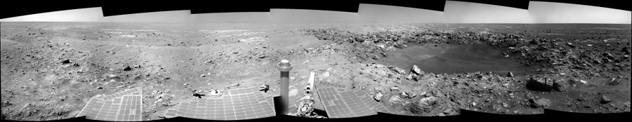
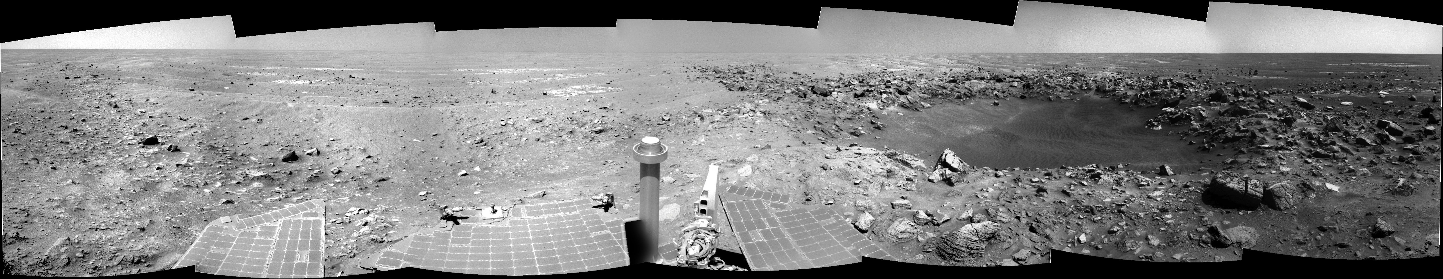
Sol 2143 view with the model at sol 2138 .The false-color Pancam image was labelled "Loboc River".
Some very interesting features on that rock, and the one to its right...
Click to view attachment
Click to view attachment
Click to view attachment
Click to view attachment
Cool!
I wonder when those fracture patterns set up on that central block. Pre-impact or post-impact?
I wonder when those fracture patterns set up on that central block. Pre-impact or post-impact?
QUOTE (Stu @ Feb 4 2010, 04:31 PM)
Some very interesting features on that rock, and the one to its right...
Interesting quasicircular feature on square-shaped rock.
Mahanay Island's a bit rough, isn't it?
Is that a ring of blueberries around the base? If so, I wonder if some scholarly soul with a knowledge of the weathering rate could put this scene to good use.
Is that a ring of blueberries around the base? If so, I wonder if some scholarly soul with a knowledge of the weathering rate could put this scene to good use.
QUOTE (Stu @ Feb 3 2010, 11:25 AM)
For me, the undercutting erosion of features like this blows away the idea that Concepcion is a mere 1000 years old. It must be much older, surely... with the caveat that I have not yet done the homework advised by Emily.
QUOTE (ustrax @ Jan 23 2010, 08:20 PM)
QUOTE (ustrax @ Jan 22 2010, 10:34 AM)
Did anyone mention the magic word? "Names"?...
The Concepción was burned on the island of Bohol, that's one cool name isn't it?...And the island as its own nice places...like Chocolate Hills...
The Concepción was burned on the island of Bohol, that's one cool name isn't it?...And the island as its own nice places...like Chocolate Hills...
Just got word from our beloved MC, the suggestion was approved, a Mars bar anyone?
This is from tosol's plan:
> 02145::p2556::24::4::0::0::4::2::10::pancam_Chocolate_Hills_L257R1
Enjoy it.
Click to view attachment
Chocolate Hills... you couldn't make it up, could you?
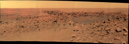
And here's an autostitched mosaic of today's navcams.
Click to view attachment
This is Chocolate Hills. Original picture here: http://qt.exploratorium.edu/mars/opportuni...C0P2556L2M1.JPG
Click to view attachment
Click to view attachment
This is Chocolate Hills. Original picture here: http://qt.exploratorium.edu/mars/opportuni...C0P2556L2M1.JPG
Click to view attachment
QUOTE (Tesheiner @ Feb 5 2010, 08:33 AM)
Enjoy it.
writing with my mouth full...

...and those are some tasty images you got there Stu!
More images in a new post on my blog, along with some background info on Bohol Island, which some of you might find interesting...
http://roadtoendeavour.wordpress.com/2010/...chocolate-hills
http://roadtoendeavour.wordpress.com/2010/...chocolate-hills
Contrast-adjusted crop of the Chocolate Hills to enhance the cracks and fissures. Filtered images 2 and 5 were combined and heavily played with:
Click to view attachment
Details and full res version here: http://www.flickr.com/photos/31678681@N07/4331802075/
The blueberries on their stems are funky!
Click to view attachment
Details and full res version here: http://www.flickr.com/photos/31678681@N07/4331802075/
The blueberries on their stems are funky!
QUOTE (Juramike @ Feb 5 2010, 01:23 PM)
The blueberries on their stems are funky!
Yep, they are!
http://twitpic.com/11hoqt/full
I *think* that might be telling something about the ages of the ejected blocks.
Noway those structures could've pre-existed prior to impact. Blocks got ejected. Failure along regions of surface "defects", putting blueberries at the crack margins. Then slow sand ablation leaves the blueberries at the end of stalks. In 10E(quoi?) years the stems will fail, and the blueberries will drop, and the stems will get ablated down to the rock surface.
So given an average blueberry diameter of 4 mm. Those stalks are about another 4 mm. Assuming the blueberries started with the tips flush at the crack margin, there has been 8 mm of erosion since block emplacement.
QUOTE (Juramike @ Feb 5 2010, 10:27 AM)
I *think* that might be telling something about the ages of the ejected blocks....
Yes, but it looks like a complicated problem, since the blueberrys on stalks (at least the ones that we can see) are in the niches that are comparatively sheltered from the erosive action of the wind.
Steve M
Sol 2145 navcam pan
Those Chocolate Hills sure do look tasty...
The latest Oppy update said we're approaching some ejecta blocks to possibly use the IDD on - perhaps Chocolate Hills?
The update also had this little tidbit:
The latest Oppy update said we're approaching some ejecta blocks to possibly use the IDD on - perhaps Chocolate Hills?
The update also had this little tidbit:
QUOTE
Some of the rocks exhibit a dark crust, potentially impact melt.
My 'pan so far' of Concepcion...
http://twitpic.com/11nwh2/full
LOoking forward to seeing the proper versions here soon!
http://twitpic.com/11nwh2/full
LOoking forward to seeing the proper versions here soon!
QUOTE (elakdawalla @ Feb 3 2010, 06:45 PM)
There's an awful lot of arm-wavey geology going on in this thread
At the risk of inviting more of the 'arm-wavey geology' highlighted by Emily what would be the underlying story with the twin craters? Would I be right in thinking it would be a meteorite that split into two on its descent through the martian atmosphere?
(I think this should be in the distant vistas thread - can someone help please!)
Neil
Consider all the possibilities:
- two separate impacts, a pure coincidence
- a meteorite that split in two
- two ejecta blocks from a distant crater, or one that split in two (i.e. these are secondary craters)
Nothing we have now could distinguish between these possibilities. One rule for arm-waving is not to stop with the first idea that comes along, but to look at all the other possibilities as well. Multiple working hypotheses! Then we can try to weed out the weaker suggestions with observations or other approaches.
Phil
Oh wow... the Chocolate Hills are turning out to be quite fantastic 3D targets...
Click to view attachment
Click to view attachment
Looking forward to more colour views of these rocks.
Click to view attachment
Click to view attachment
Looking forward to more colour views of these rocks.
I don't usually do this kind of thing, but...
Does anyone else think Oppy has found her companion?
Does anyone else think Oppy has found her companion?
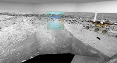
So, updated version of the Sol 2140 color pan of Concepcion. We can now see it entierely :
(I prefer to link to my page because the direct link to the full version will lead to load a 4.4 Mo pic).
(I prefer to link to my page because the direct link to the full version will lead to load a 4.4 Mo pic).
Ooooohhhh.... Easily one of my most favourite 3D views yet...
Click to view attachment
... and straightened out a bit...
Click to view attachment
Click to view attachment
... and straightened out a bit...
Click to view attachment
Garg!!! What can I say, what can anyone say: damn cool is all, Stu, wow! What an amazing rock, and your 3Ds always kick ass; well done!!!
QUOTE (Stu @ Feb 7 2010, 11:56 AM)
The shapes on this (left) rock look like an ancien map of the (Mars) world, don't you think?
So it wasn't just me.
I saw a shape similar to north and central america on it.
I saw a shape similar to north and central america on it.
This is a "lo-fi" version of our main content. To view the full version with more information, formatting and images, please click here.