Full Version: Post Block Island Meteor Studies (The Western Route)
That it's not even in the Navcam drive direction mosaic would infer one of two things. They drove in the wrong direction (unlikely) or they don't intend to visit it (more likely) and drove this way for the pavement texture it offers for a few hundred metres. Although there are some big dunes about 150-250m ahead that I'm looking forward to seeing a route around.
Would a predominantly southerly direction be expected on this new pavement?
You can see for yourself on ET's route maps - I would suggest W or SW for another 250-500 metres, before heading south for quite a while before making the turn East.
According to the data we should be pretty close to it (the accuracy here is questionable, though). I'd be pretty surprised if they didn't get a picture.
My updated guess on the position of 'new rock'
Oppy should be to the northeast of the rock (almost on top of it)
Click to view attachment
cheers
Oppy should be to the northeast of the rock (almost on top of it)
Click to view attachment
cheers
QUOTE (centsworth_II @ Oct 14 2009, 06:55 PM) 
hortonheardawho gets the scoop. Mackinac.
I like it...:
The island is a sacred place in the tradition of some of its earliest known inhabitants, the Anishinaabe (Ojibwa) tribes, who consider it to be home to the Gitche Manitou, or the "Great Spirit".According to legend, Mackinac Island was created by the Great Hare, Michabou and was the first land to appear after the recession of the Great Flood.The island was a gathering place for the local tribes where their offerings were made to Gitche Manitou and was where tribal chiefs were buried.

Pronounced "Mackinaw", by the way...
QUOTE (PDP8E @ Oct 14 2009, 06:14 PM)
My updated guess on the position of 'new rock'
Looks very reasonable to me. The updated position is quite a bit closer to SI than my original guess earlier in this thread, so "new rock"/Mackinac is smaller than I guessed then, maybe around 40cm across.
It's interesting knowing that the rock is looming not far off to our left, invisible in the images returned. Can't wait to see the closeups.
In terms of stopping at the rock vs driving, I think it would be hard for the team to justify passing a potential science target by that was so close to the drive path. For those eager to keep going, the stop at SI was about a fifth of the total delay for BI, so if Mackinac turns out to be a similar meteorite I doubt we'd have a long delay.
And centsworth: it's good to know someone is still monitoring the "other" forum!
Now this last move makes sense to me.
Let's see if the stop is short or not; it'll basically be driven by the use (or not) of the MB. If we see a sequence indicating the Mossbauer placement, expect a long stop; otherwise, we may be leaving during the weekend.
Let's see if the stop is short or not; it'll basically be driven by the use (or not) of the MB. If we see a sequence indicating the Mossbauer placement, expect a long stop; otherwise, we may be leaving during the weekend.
Endeavour crater on the horizon (Sol 2010 colour pan). Two version with one no stretched centered on Endeavour, and one with the whole horizon but stretched to see the relief in a better way.
So, "drive, drive, drive" as Steve said
So, "drive, drive, drive" as Steve said
A nice stretched view! At the right we get a good look into the subded crater we still have to drive around.
Phil
Phil
If we are driving around a subdued crater that could offer an alternative explanation for the cluster of meteorites. The surface we are driving over was part of the crater rim so it was subject to additional erosion exposing more meteorites.
QUOTE (Ant103 @ Oct 14 2009, 10:23 PM)
Endeavour crater on the horizon (Sol 2010 colour pan). Two version with one no stretched centered on Endeavour, and one with the whole horizon but stretched to see the relief in a better way. So, "drive, drive, drive" as Steve said
Fourmi 103, your horizon image is a real torture to those, like Phil and you, are willing to explore those distant peaks.
And we are only 1 or 2 km north from a crest that should reveal to us the whole structure. The rovers are ageing and it could be a real misfortune to have a mission ended short of those (geologic) "Treasure Islands", by spending too much time at every meteorite found locally. This mission is devoted to follow a "water trail", which was also the goal for which the MER budget was accepted for FY' 01. Of course, there are other discoveries that can be made following this trail, but not forgetting the primary goal of this mission.
Derived from my experience (I helped build the Mars Outreach at JPL for MPF), I think we are now becoming short of spectacular views to re-vitalize the Mars exploration budget among Congresspeople.
I've also recently tested some Oppy's images among the public : people are getting bored now by those endless dune fields.
==> Then for Outreach reasons (which are also to be also considered for future Mars budgets), my strong recommendation for a strategy to revitalize this mission is that we run as fast as possible until we go over the crest and see the whole Endeavour "skyline" with its peaks to give the Public spectacular images. Only then we can make stops for interesting rocks (even meteorites), knowing that Endeavour will be growing in size everyday in the images to keep people on an "alert mode" for future discoveries

Pancams are down. We either missed it or this rock is really small. 
http://qt.exploratorium.edu/mars/opportuni...MTP2426L2M1.JPG
http://qt.exploratorium.edu/mars/opportuni...MTP2426L2M1.JPG
http://qt.exploratorium.edu/mars/opportuni...MTP2426L2M1.JPG
http://qt.exploratorium.edu/mars/opportuni...MTP2426L2M1.JPG
"New rock", Mackinac. I think this one should be named "Hidden Rock" instead. 
QUOTE (briv1016 @ Oct 15 2009, 09:26 AM)
We either missed it or this rock is really small.
Didn't look small from afar...maybe it ran away...

EDITED: not small at all...:
Click to view attachment
Or we are parked right on top of it
 They leave it late again (is that a way of putting it here (in German: spannend machen) too?)
QUOTE (vikingmars @ Oct 15 2009, 10:05 AM)
... (geologic) "Treasure Islands" ...
Very well put, vikingmars ! Fully agree with everything you wrote !
To add one more aspect to the importance of reaching as far a goal as Endeavor is: Actually roving to a place so far away from the original landing ellipse is almost the same as if we had landed an entirely new spacecraft at another place on the planet ... to the price of just one single rover ! ... using it's wheels for what they were made for ... as the robot geologist's magic wings - the greatest very-long-range science instrument deployment tool ever sent to another planet
A bird in the hand is worth two in the bush. If you have a known science target nearby, you go for it rather than drive another 15 kilometers to somewhere you cannot be sure is reachable. As much as I want to get to Endeavor as soon as possible, doable and immediate science is a priority. Although Endeavor is a target we are generally headed toward for another possible mission extension, the current stated and approved mission goal is to study the cobbles on the plain. We cannot pass up anything of interest.
The only logical way to tackle it is compromise. Study science if there's some to be done - otherwise, drive.
That's what we're doing.
Moaning that we're not going quick enough, or not stopping enough is inappropriate and pointless.
That's what we're doing.
Moaning that we're not going quick enough, or not stopping enough is inappropriate and pointless.
QUOTE (Tesheiner @ Oct 15 2009, 09:47 AM)
I think this one should be named "Hidden Rock" instead.
I'm baffled by the 2035 pancam sequence. What baffles me is, after a 70 m drive, how can they target two pancam frames at "Mackinac"? The uncertainty in the rover position after such a long drive would surely make that really hard. Isn't the normal procedure to identify any objects of interest (and their azimuths/elevations) after a drive in a wide navcam pan, and then do followup with pancam?
Here's my speculation. The 2035 pancam sequence is pointing west, roughly in the middle of the post-drive 3x1 navcam sequence. They intended the drive to end up just east of new rock/Mackinac, with the rock squarely inside both sequences. Had they been accurate in the drive, not having to target pancam the next sol would've saved them a sol. However, they drove long/too far north, and Mackinac is out of both sequences. If I'm right, we'll see the remaining 7 navcam frames taken next to localize the rock.
Here's a parting shot of Shelter Island, from sol 2034. Pancam anaglyph, with heavy rotation between the frames that I couldn't correct perfectly:
Click to view attachment
Click to view attachment
There's not a single person here doesn't want to get to Endeavour, who isn't "willing to explore those distant peaks", but that doesn't mean we can't stop to enjoy the scenery and the unexpected bonuses along the way. There's absolutely no guarantee Oppy will reach Endeavour: every sol is a bonus now, and has been for a long, long time. She could stop working at literally any moment, so not stopping to study an interesting rock, or meteorite, our outcrop, just because it might take a couple of days, makes no sense at all. Every cobble, dune, meteorite and stone, is something we're seeing for the first time, and we have no idea how important they could be until we stop and look at them. That's part of the thrill of exploration, isn't it?
When we eventually start heading towards Endeavour properly, and can see the hills in more detail, does anyone really think the rover should dash non-stop for the foothills, ignoring stones along the way, when some of them could actually be from the crater, and would give us an (ahem) opportunity - perhaps our only opportunity - to study it before Oppy's wheels roll for the last time? I doubt it.
C'mon now everyone, let's just enjoy the ride.
Final "parting shot" of 'Shelter island'...
Click to view attachment
QUOTE (Stu @ Oct 15 2009, 08:32 AM)
There's not a single person here doesn't want to get to Endeavour, who isn't "willing to explore those distant peaks", but that doesn't mean we can't stop to enjoy the scenery and the unexpected bonuses along the way. ...
I only have this from reading this forum, and Emily's publications, but I have the impression that Oppy can drive for a week or so, and then should stop to let something happen with wheel lubrication for a week or so. If that's true then this stopping at every scenic overlook and scientific opportunity is a requirement, not just a good philosophy. Can someone in the know please fill me in on how close to true this is?
The required stops have been after about a month or a kilometer of driving, I don't remember which was the limiting factor. Heating the wheel may allow them to extend that (assuming Oppy can avoid discovering anything interesting for that long)
I never thought I'd hear someone insinuate a complaint that Opportunity is discovering too much! Wow.
These are crazy times. We missed discovering water on Luna, which spurs us on to look for it on Mars. MER finds evidence of past water and Phoenix directly finds it near the surface. And in one case some liquid is found near the landing pad in an image. This spurs us on to reevaluate data from all old missions. Which may have eventually helped us to find H2O (small amounts) on the moon.
We are living during a whole paradigm shift in space exploration. And it's due in large part because of the findings of this little rover, Opportunity! Amazing.
QUOTE (MarsIsImportant @ Oct 15 2009, 07:06 PM)
And it's due in large part because of the findings of this little rover, Opportunity! Amazing.
If I was you, I'll change my name to "OpportunityIsImportant"

From the latest Oppy update, a brief mention of "new rock":
(Edited to permanent link.)
QUOTE
On Sol 2034 (Oct. 14, 2009), Opportunity left "Shelter Island" and headed northwest driving 64 meters (210 feet) backwards toward another large rock (more than half a meter or 1.5 feet).
(Edited to permanent link.)
QUOTE (fredk @ Oct 15 2009, 05:45 PM)
... a brief mention of "new rock":
Is "New Rock" another meteorite?
Staring at SFJCody's jpg of the google-map, I noticed what appears to be a relatively recent small impact crater ~500m to our south. I made a few notes to the map, with a guess to where we might be going after the recent rock-a-palooza:
Click to view attachment
I agree
Any chance it'll be Oppy's cruise stage?
QUOTE (climber @ Oct 15 2009, 11:24 PM)
Any chance it'll be Oppy's cruise stage?
I would expect that the cruise stage would be downrange of the landing ellipse.
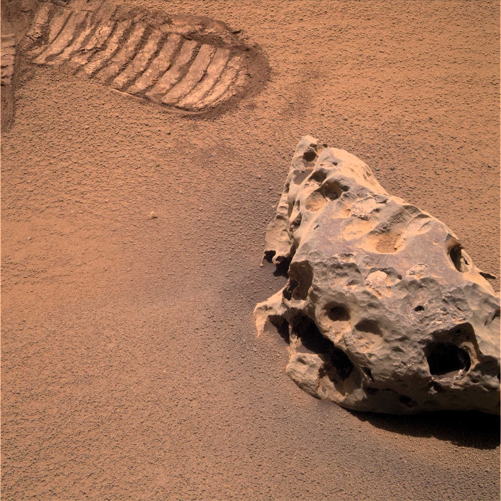
We finally have full 360 degree navcam coverage on this site. And here's our "lost" rock.
Click to view attachment
Edited: ... and a mosaic to put the rock into context.
Click to view attachment
Click to view attachment
Edited: ... and a mosaic to put the rock into context.
Click to view attachment
Wow... this one is pretty badly beaten up, poor thing...
Click to view attachment
And 3D view: http://twitpic.com/lpor5
Click to view attachment
And 3D view: http://twitpic.com/lpor5
QUOTE (Tesheiner @ Oct 16 2009, 08:46 AM)
Edited: ... and a mosaic to put the rock into context.
OK, looks like there's no more funny rocks in the horizon...time to lift some Meridiani dust!
"Funny rocks"?!?!?!?! Call yourself an explorer?!?!? 
I think "poor thing" is not much better 
Edited: Rui, you're 1 post ahead of me! Who'll be the first to reach 2K?
Edited: Rui, you're 1 post ahead of me! Who'll be the first to reach 2K?
Does anyone need to go to the toilet? Yes, ok, then let us get a nice sight all around it...
Isn't there a significant similarity between these meteorites. Holed and broken-like. Is Oppy able to get an accurate enough measurement to conclude that they are of the same (identical) composite?
Isn't there a significant similarity between these meteorites. Holed and broken-like. Is Oppy able to get an accurate enough measurement to conclude that they are of the same (identical) composite?
QUOTE (Stu @ Oct 16 2009, 10:06 AM)
"Funny rocks"?!?!?!?! Call yourself an explorer?!?!?
Man, this rocks cross space to sit there for ages waiting for us, just to prevent us to put the pedal to the metal...let's just say that they have a strange sense of humour...
And yes climber...2000 it is! 2000 posts of pure cookiness, hope you enjoyed them as much as I...

QUOTE (ustrax @ Oct 16 2009, 12:51 PM)
hope you enjoyed them as much as I...
I don't know for the 2 remaining, but so far, so good!
Sol 2034 full pan :

And... oh? I forget to post this, Shelter Island on Sol 2032 :


And... oh? I forget to post this, Shelter Island on Sol 2032 :
QUOTE (mhoward @ Oct 14 2009, 10:51 AM)
According to the data we should be pretty close to it (the accuracy here is questionable, though).
Looks like the tracking data was pretty accurate after all.
QUOTE (Tesheiner @ Oct 16 2009, 08:46 AM)
And here's our "lost" rock.
Sure enough! And only 2.9 metres away. Impressive targetting after a 64 metre drive (even if they missed it in the first sequences). At that distance I measure about 32 cm across, though I think it's a fair bit wider in the other direction.
Oh my ...!
You've done a great job with the pan Phil !
You've done a great job with the pan Phil !
Phil that is fantastic work
Using the Ant103-to-Stooke (A2S) projection , and comparing it to the HiRise, it is now very easy to see where the rock is.
Click to view attachment
Phil, what tool do you use to do circular projections?
Click to view attachment
Phil, what tool do you use to do circular projections?
Photoshop!
(the filter-distort-polar projection tool, applied to a panorama that has been stretched vertically and then had its foreground compressed vertically)
Phil
(the filter-distort-polar projection tool, applied to a panorama that has been stretched vertically and then had its foreground compressed vertically)
Phil
This is a "lo-fi" version of our main content. To view the full version with more information, formatting and images, please click here.