Help - Search - Members - Calendar
Full Version: yellow brick road to the south
Unmanned Spaceflight.com > Mars & Missions > Past and Future > MER > Opportunity
Pages: 1, 2, 3, 4, 5, 6, 7
Nirgal
QUOTE (Pando @ Nov 5 2008, 07:32 PM) *
*gasp* In addition to arthritis, Opportunity has caught a severe case of mallarditis!!!

laugh.gif


now officially confirmed by new navcam imagery (link) !
smile.gif
fredk
I'm actually not very surprised by our new stowaway friend. There were so many back at Duck Bay.

Quack, quack! laugh.gif
ustrax
I'm quite surprised no one recognized yet (some prefer not to...) who the stowaway is...
Would you actually believe this guy would stay sitting at the beacon for eons and eons after all the fun we had?... wink.gif
Come along! biggrin.gif

EDITED: And aparently this is not the first time our brave DD took a ride... rolleyes.gif
climber
QUOTE (ustrax @ Nov 5 2008, 09:46 PM) *
I'm quite surprised no one recognized yet (some prefer not to...) who the stowaway is...

Are we gona have a Beacon farewell party?
climber
QUOTE (djellison @ Nov 5 2008, 05:33 PM) *
Don't assume that just because we're facing one way or the other at the end of a drive, that that is the direction we drove.
Doug

Thanks for you input Doug.
When I first looked at the picture, I sew some 5m (?) away, while still on pavement, what can be interpreted as a 180° manoeuver turn; This is why I said we're driving backward and not because of the heading. Looking closely, I may be wrong.
Bobby
Beacon will soon be a Far Rim Object rolleyes.gif
RoverDriver
QUOTE (djellison @ Nov 5 2008, 08:33 AM) *
Don't assume that just because we're facing one way or the other at the end of a drive, that that is the direction we drove.

Not only do drives often end with a turn-in-place to make the best of any upcomming UHF pass, but drives can often include a switch from one direction to the other mid drive. As an example, the one-sol-record of 219.89 metres included 110m of blind driving backwards, followed by 109m of autonav forwards.


Doug

Doug is correct. The end of drive direction is usually set to maximizing the DL volume but sometimes, if we are approaching an IDD target, we might want to minimize rover shadows on the science target(s).

Drive orientation of the rover is selected based on other factors. For Autonav the rover needs to drive forwards since we do not have a clear view behind the rover (LGA in the field of view).

If the only features that Visual Odometry can lock on are the rover tracks we have a slightly better performance driving backwards and looking at the tracks in front of the vehicle.

This is why on some of the recent long drives we begin driving (no autonav) backwards since we periodically use VO to determine rover slip. We then turn around 180 degrees for the autonav remaining portion.

When driving on slopes, we also have a slightly better vehicle perfomance driving uphill backwards. This is why we did the Duck Bay toe-dip and egress driving backwards.

These are some of the factors we take into account when deciding which end goes first, but there are other factors as well (minimizing the amount of turning, distributing wear and tear on the actuators...).

Paolo
Enceladus75
Well I, for one, welcome our new Duck Overlords... laugh.gif

At this point Oppy must be nigh on 1 kilometre from Victoria already! smile.gif
Phil Stooke
"Beacon will soon be a Far Rim Object"

And at long last all we near-rimmers will owe everybody else a big apology for being so stubborn!

Phil
climber
QUOTE (RoverDriver @ Nov 6 2008, 12:58 AM) *
...Drive orientation of the rover is selected based on other factors...
Paolo

This is a very interesting piece of information.
I went throught quite some pictures since we left Vicky and didn't see any 180° except, even if I was wrong, on the picture shown above.
Does this mean that Oppy use pictures that are not sent back to Earth then?
This is a question to who know the answer, not necesserly Paolo.
Thanks

Tesheiner
QUOTE (RoverDriver @ Nov 6 2008, 12:58 AM) *
Paolo

Glad to see you back online again! smile.gif

QUOTE (climber @ Nov 6 2008, 09:42 PM) *
Does this mean that Oppy use pictures that are not sent back to Earth then?

Dunno if all visodom pictures are downlinked. I would say "yes, given the right priority is given to this kind of images and if they are not explicitely deleted to free the flash memory". Example of these pictures can be found here: http://qt.exploratorium.edu/mars/opportuni...cam/2008-11-03/. Check all those navcams with the id "F0006" on the filename.
tim53
QUOTE (fredk @ Nov 4 2008, 12:57 PM) *
The latest official Oppy route update has a dashed line that may be a plan/projection/guess as to our future route, following the exposed bedrock towards the SSW.


That's about right.

I don't like to put future paths on my own maps because surprises along the way will always alter the details.

But you guys have the general idea. We need to steer SSW a bit from Victoria to get around large "purgatoid" fields SE and E of Victoria and still take advantage of the N-S general trend of ripples.

This route gets us past the purgatoids in about 5km, after which it should be more like driving around Endurance was, all the way to Endeavour.

-Tim.
ustrax
QUOTE (tim53 @ Nov 6 2008, 10:48 PM) *
This route gets us past the purgatoids in about 5km, after which it should be more like driving around Endurance was, all the way to Endeavour.


Thank you for the information!
Do you mean that Oppy will rove another +-5kms SSW from the current position or from the end of the dashed line in the latest route map?
I'm curious to see where will she make the turn towards the East, according to your words, and of course counting with eventual surprises, but this seems to put Oppy in the same frequency with my path hypothesis...
Ah! Interplanetary telekinesis...never ceases to surprise me... tongue.gif
climber
QUOTE (Tesheiner @ Nov 6 2008, 10:10 PM) *
Check all those navcams with the id "F0006" on the filename.

Thanks so much Eduardo, this is very informative.
Tesheiner
QUOTE (tim53 @ Nov 6 2008, 11:48 PM) *
But you guys have the general idea. We need to steer SSW a bit from Victoria to get around large "purgatoid" fields SE and E of Victoria and still take advantage of the N-S general trend of ripples.

This route gets us past the purgatoids in about 5km, after which it should be more like driving around Endurance was, all the way to Endeavour.


Thanks for the info Tim!
There is a pretty big field of dunes about 3km SSW of the current position. Which is the plan to avoid it; east or west of the field?
Click to view attachment

Edited: Background image is from jamescanvin's terrain analysis.

QUOTE (ustrax @ Nov 7 2008, 08:51 AM) *
Ah! Interplanetary telekinesis...never ceases to surprise me... tongue.gif

Interplanetary? So who lives in another planet? tongue.gif tongue.gif
ustrax
QUOTE (Tesheiner @ Nov 7 2008, 11:04 AM) *
Interplanetary? So who lives in another planet? tongue.gif tongue.gif


Hey! I'm only here to visit some relatives... wink.gif

Here's my updated map including the direction to follow present in JPL's latest release:
Click to view attachment

About the dunes you make reference to Tesheiner it looks like the place where I've put Oppy making the turn towards the East.
Tesheiner
> About the dunes you make reference to Tesheiner it looks like the place where I've put Oppy making the turn towards the East.

Here're the two pictures put together.
Click to view attachment
PhilCo126
nice jobs ustrax & Eduardo !
dd.gif
ustrax
Thanks Tesheiner but the East turn I made reference to it's not that one yet...it's further south, in the second leg of the original route suggestion, this one here, is near the "n" in "8 months"... wink.gif

Tesheiner
Ooops! rolleyes.gif
Here's your map and james' put together.
Click to view attachment
mhoward
Opportunity's drive on Sol 1702 (seen from the Sol 1700 site):


And here's a QuickTime VR for Sol 1702 (1.75MB). Shouldn't be too hard to locate Opportunity on the map today smile.gif
Tesheiner
At last some pictures from the new site! There was a drive on sol 1702.
Here's a navcam mosaic.
Click to view attachment

Now let me locate it in the route map...
tim53
QUOTE (ustrax @ Nov 6 2008, 11:51 PM) *
Thank you for the information!
Do you mean that Oppy will rove another +-5kms SSW from the current position or from the end of the dashed line in the latest route map?
I'm curious to see where will she make the turn towards the East, according to your words, and of course counting with eventual surprises, but this seems to put Oppy in the same frequency with my path hypothesis...
Ah! Interplanetary telekinesis...never ceases to surprise me... tongue.gif


Your route is similar to one we proposed to the science team about a month ago. Details are a bit different, of course - like I thought we should take the east side of the crater you label "Porcupine", and cut east sooner. We'll have to see what it looks like when we get there.

Again, of course, the actual path often depends on where we end up in relation to nearby ripples at the end of a drive!

-Tim.
fredk
QUOTE (tim53 @ Nov 6 2008, 11:48 PM) *
This route gets us past the purgatoids in about 5km, after which it should be more like driving around Endurance was, all the way to Endeavour.

I like the sound of that! I suppose we can interpret this as a sneak preview of what the new hirise imagery shows unsure.gif smile.gif

Ustrax, that must have been quite the Valentine's delirium! I'm a bit puzzled though, on Valentine's day shouldn't you be channeling the god goddess Venus instead of Mars? laugh.gif mars.gif
ustrax
QUOTE (tim53 @ Nov 7 2008, 04:19 PM) *
Your route is similar to one we proposed to the science team about a month ago.


Tim, I must be honest, when I draw that line I didn’t look to the available HiRise image and, of course, there were no images with that sort of detail for the terrain in between Victoria and Endeavour, what I did was mostly connect the dots between possible scientifically interesting targets (the ones marked with white circles).
For the drive itself I tried to followed what looked like exposed bedrock.
Regarding Porcupine that was also the reason I took the west route, because it looked to me, without HiRISE detail, that it had more solid ground around the rim.
Cool to see that some assumptions made back then where confirmed by reality... smile.gif

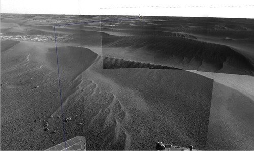
Tesheiner, I love that mosaic! What an extraordinary place!
And thanks for the maps composite, I might be wrong but I have the feeling that we’re all talking about the same thing here, turn East when facing those dunes +-5kms from the current position.
Here's my updated map with sol 1702 drive:
Click to view attachment
Looks like I'm a week late... rolleyes.gif

Fredk, on that occasion I was in psychic conjunction with Venus... wink.gif
RoverDriver
QUOTE (climber @ Nov 6 2008, 12:42 PM) *
This is a very interesting piece of information.
I went throught quite some pictures since we left Vicky and didn't see any 180° except, even if I was wrong, on the picture shown above.
Does this mean that Oppy use pictures that are not sent back to Earth then?
This is a question to who know the answer, not necesserly Paolo.
Thanks

There is a large portion of data that is acquired but not downlinked. We might acquire images for diagnostic purposes that if all goes well we do not need to send to Earth and look at. Most of the autonav and visodom images also are not required to be sent to Earth either. I haven't been on MER-B since sol 1674 so I'm not sure how many of those drives had the 180 degrees flip.

Paolo
CosmicRocker
Psychic conjunction??? laugh.gif LOL!

On a more serious note, when might we expect to see that new HiRISE image?
ustrax
Tom,SS says "I don't think it will be long"...now the question is...how long is that?... rolleyes.gif

Two more notes I got from our PI yesterday, maybe this is something that you already know but for me it's new, I asked if there is an idea about how many drives or distance to be covered by Oppy until solar conjunction, according to SS, drives yes, distance no. But there was no mention to how many of them will be...maybe someone here knows the answer to that? smile.gif

I've alsoasked about one scenario: seing Oppy reaching Porcupine until conjunction, the idea was presented as a scientifically profitable scenario to SS but I had second intentions...trying to turn Meridiani into some sort of Monza...a great stretch isn't it?...
The Cobble is the target for the team, and Steve tells us that Porcupine is, as we all might think, "too far to go before conjunction", case closed...oh...wait...did I mention that the PI completed the sentence with a "I think"?.... tongue.gif

Porcupine is what? 1.8, 2 kms far from the current position? And we have what? 3 weeks until conjunction? That leaves with...6, 9 drives?
Yep...hard to get there, 2kms and 9 drives gives us an average of 222m...
Stu
Some nice detail visible on the ground in this 3D pic...
Nirgal
QUOTE (ustrax @ Nov 8 2008, 10:02 AM) *
Porcupine is what? 1.8, 2 kms far from the current position? And we have what? 3 weeks until conjunction? That leaves with...6, 9 drives?
Yep...hard to get there, 2kms and 9 drives gives us an average of 222m...


Shouldn't the current restricted-sols period end soon ?
Would mean every day a drive day and oppy could progress at about twice the speed it has for the last weeks.
djellison
rolleyes.gif

Still with the x / sol * y days.


Astro0
A different view of the Sol1702 location. Enjoy.
Stu
Really like that, Astro0. Beautiful landscape we're moving through right now... smile.gif
Juramike
Absolutely beautiful, Astro0!
Zeke4ther
It is people like you that brings the reality of Mars home. Beautiful desolation...
mhoward
Some more just came down from Sol 1702 (QuickTime VR 2.4 MB).

P.S. Speaking of autonav images, a bunch just came down for the outbound from Victoria journey, especially for sol 1693. At least I've always assumed that's what those downsampled Navcam images are; they match the description, since they're only covering the later part of the drive. It's not really enough for a movie (yet) but it helps fill in the long distances in image coverage between sites, which is cool.
ElkGroveDan
You know Mike, some MMB addicts (not me of course) who are now growing fond of the QT VRs to might soon suggest that you find a way to automate the creation of the QT VRs the way you did with the anaglyphs and color layers. MORE ! MORE ! we want MORE Mars! laugh.gif
Nirgal
QUOTE (Astro0 @ Nov 8 2008, 01:14 PM) *
A different view of the Sol1702 location. Enjoy.


Wonderful !

(I like lens flare effects, when so subtly applied like that )
mhoward
QUOTE (ElkGroveDan @ Nov 8 2008, 08:47 AM) *
You know Mike, some MMB addicts (not me of course) who are now growing fond of the QT VRs to might soon suggest that you find a way to automate the creation of the QT VRs the way you did with the anaglyphs and color layers. MORE ! MORE ! we want MORE Mars! laugh.gif


Thanks. Yeah, I'm thinking about creating a slicker and more user-friendly program based on MMB, maybe, someday. There's so much that could be done there. The problem is time; at the moment I'm quite busy improving certain - cough - other projects.

I'm curious (and maybe the MMB thread would be better for this) if people see a huge difference in quality between the QTVRs and just using MMB. The answer might decide what direction I go at some point.
Nirgal
QUOTE (djellison @ Nov 8 2008, 11:16 AM) *
rolleyes.gif

Still with the x / sol * y days.


I know, I know wink.gif

It's just for the fun of speculating a bit ...
jekbradbury
QUOTE (mhoward @ Nov 8 2008, 12:23 PM) *
I'm curious (and maybe the MMB thread would be better for this) if people see a huge difference in quality between the QTVRs and just using MMB. The answer might decide what direction I go at some point.


One difference I have noticed is that the QTVRs let you zoom out much farther. This enables quick n' dirty vertical projections (looking straight down) to cover a larger area than in MMB.
Tesheiner
Sol 1704 was another driving day, and Opportunity moved 80m+ SW.
Images should be available soon at the exploratorium.
wheel.gif wheel.gif wheel.gif
CosmicRocker
Tesheiner: Has anyone recently told you how much your efforts are appreciated here? Thanks for the info... wink.gif
djellison
Yellow bricks, for a yellow brick road.

Drive dir. images end of sol 1704.
djellison
And Navcam mosaic with the R2/R1 Pancam frames overlayed.
Tesheiner
Nice one. smile.gif
Note that these post-drive mosaics are heading south and not SW. It's an indication that the future path (the next move at least) is on that direction. Enough drift SSW for the time being?
remcook
Looking at your routemap just before I thought: if we now head straight south we can just squeeze in between the bigger dunes. It's nice to be on the road again smile.gif
Juramike
Is this one of those things we're supposed to be looking for?
Click to view attachment
Juramike
Couldn't resist! laugh.gif
Click to view attachment
Juramike
Here's a proposed route that could examine the cobble, and put Oppy on a dune free huge pavement ("The Runway") stretch in a few sols.
(after an easy run through two half pipes - one of which we can already see in the Navcam image)
Click to view attachment

Following the SW trending pavement further, after an additional "Runway" length, the route passes by two cute craters (worth a peek?), then an additional pavement stretch, then into a smooth area (old crater?) that then joins the proposed SW route "drain":
Click to view attachment

-Mike
This is a "lo-fi" version of our main content. To view the full version with more information, formatting and images, please click here.
Invision Power Board © 2001-2024 Invision Power Services, Inc.