Nirgal
Nov 14 2008, 08:29 AM
QUOTE (CosmicRocker @ Nov 14 2008, 08:35 AM)

Driving or science? Which will take precedence here? Perhaps neither, the choice is not clear to me.
Why do we always "play off" science against driving ? .... As if the driving was just for fun.
How about the equation "driving = science" ...
For, in a sense, the driving could be viewed as a very long range science instrument deployment ... the deployment of our instruments to Endeavour, for example.
Rather it seems a question of priorites as in "science here" vs. "science there (at Endeavour)" for which I would always vote for the latter

just a thought.
djellison
Nov 14 2008, 09:21 AM
1709 looks like 95m SE - onto the edge of a large area of pavement. I've tacked a guess onto Tesh's 1707 map, but leave it to him to do a proper version for the route map thread.
Doug
djellison
Nov 14 2008, 10:24 AM
Nice driving ground.
climber
Nov 14 2008, 11:38 AM
Big dunes on the side of a sand clean area, could it be a "cleaning event" place?
Juramike
Nov 14 2008, 12:38 PM
Cool-o! There are some pretty long fractures out there on the pavement!
Are there fewer blueberries in/on the rock there than on average?
(Kinda looks that way to me)
BrianL
Nov 14 2008, 01:27 PM
QUOTE (climber @ Nov 14 2008, 05:38 AM)
Big dunes on the side of a sand clean area, could it be a "cleaning event" place?
I don't think they have yet determined whether these rocks have been swept clean, or deposited on the sand.

mhoward
Nov 14 2008, 01:55 PM
QUOTE (djellison @ Nov 14 2008, 03:21 AM)
1709 looks like 95m SE - onto the edge of a large area of pavement. I've tacked a guess onto Tesh's 1707 map, but leave it to him to do a proper version for the route map thread.
Sol 1709 Navcam QuickTime VR (1.7 MB)
TheChemist
Nov 14 2008, 02:01 PM
Apologies to any japanese members, but this is the most beautiful rock garden in the solar system
mhoward
Nov 14 2008, 02:41 PM
It has a nice view, too (as Doug already posted). The drive direction mosaic this time spans 108 degrees from due east to due south.
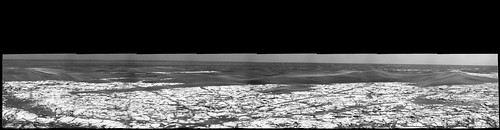
This may be an obvious comment after five years, but stitching these mosaics is kind of addictive. Edit: Replaced it with a higher res version.
ustrax
Nov 14 2008, 02:45 PM
Beautiful!

So many times we have thought about this ground, far from Victoria...and now we're here...seing it for the first time...impressive!
Doug, if your map is correct, it looks like the paths, the hypothetical and the real, converged once more...I feel more comfortable now...
 Click to view attachment
climber
Nov 14 2008, 03:20 PM
QUOTE (mhoward @ Nov 14 2008, 03:41 PM)
It has a nice view, too (as Doug already posted). The drive direction mosaic this time spans 108 degrees from due east to due south.
An Island in the "Sea of Sand"...
fredk
Nov 14 2008, 03:23 PM
These are the first eastward-pointing pancam views in a while. I believe this is a piece of Endeavour poking over the horizon, perhaps our first view of our long-term destination since Victoria?
Click to view attachment
fredk
Nov 14 2008, 03:41 PM
There's an interesting boundary cutting across the bedrock "island" before us. You can see it clearly in this navcam - the bedrock is darker on the near side of the green line than on the far side:
Click to view attachmentI've identified it in the orbital view (green line), together with the sol 1709 location:
Click to view attachmentAny thoughts on what we're seeing here? Topography/shading? Light or dark coating on one side? Different composition of rock?
MahFL
Nov 14 2008, 04:25 PM
QUOTE (fredk @ Nov 14 2008, 04:23 PM)
These are the first eastward-pointing pancam views in a while. I believe this is a piece of Endeavour poking over the horizon, perhaps our first view of our long-term destination since Victoria?
I noticed that too.
ElkGroveDan
Nov 14 2008, 04:33 PM
QUOTE (fredk @ Nov 14 2008, 09:41 AM)
There's an interesting boundary cutting across the bedrock "island" before us.
Good eye. You'd be a good person to hike through the Grand Canyon with, Fred.
BrianL
Nov 14 2008, 05:15 PM
QUOTE (mhoward @ Nov 14 2008, 08:41 AM)
The drive direction mosaic this time spans 108 degrees from due east to due south.
They know we've caught on, and don't want to tip their hand anymore.

Perhaps this indicates that they are looking for areas on the runway to get up close and personal with. I would be very surprised if this meant a long range turn to the SE.
Ant103
Nov 14 2008, 05:24 PM
In effect, it's a nice place to drive, which is remember me a famous french bicycle race named Paris-Roubaix. There are tracks were you must have roll on true pavements of stone (like thus we can find in old town center).
Just for fun, I have played with the last FHC view (reprojected into equirectangular, and colorized).
I'm wondering if somone can make a QTVR of this (and if my reprojection is good with a 120° of FOV)?

Tman
Nov 14 2008, 05:28 PM
the solar conjunction nears (see LASCO C3 movie)
http://sohowww.nascom.nasa.gov/data/realtime/mpeg/Left hand is Mars, the other Mercury.
centsworth_II
Nov 14 2008, 05:29 PM
QUOTE
(mhoward @ Nov 14 2008, 08:41 AM) *
The drive direction mosaic this time spans 108 degrees from due east to due south.
Maybe it's such a neat view, they decided to make a 'poor man's panorama.'
mhoward
Nov 14 2008, 05:45 PM
QUOTE (centsworth_II @ Nov 14 2008, 11:29 AM)
Maybe it's such a neat view, they decided to make a 'poor man's panorama.'
It's labelled "pancam_drive_direction_R12", but you might be right. Maybe 200 years from now this is where the "scenic overlook" will be located.
climber
Nov 14 2008, 06:05 PM
QUOTE (Ant103 @ Nov 14 2008, 06:24 PM)
In effect, it's a nice place to drive, which is remember me a famous french bicycle race named Paris-Roubaix.
Nice and different view Ant!
Regarding Paris-Roubaix, this race is (nearly every year) run during rainy conditions hence slipery pavments.
The pavment here is the only place where we're sure not seing any slipery.
PhilCo126
Nov 14 2008, 06:53 PM
dburt
Nov 14 2008, 09:19 PM
QUOTE (fredk @ Nov 14 2008, 08:41 AM)
...Any thoughts on what we're seeing here? Topography/shading? Light or dark coating on one side? Different composition of rock?
Echoing EGD, good eye! Inasmuch as the semi-planar surface of the bedrock appears wind-scoured (sand-blasted), and the contact is fairly linear, I'd guess that we're looking at two different layers of rock (slightly tilted up, perhaps; "very weakly dipping" to the geologist), rather than a difference in coating or topography. Just a guess, mind you.
-- HDP Don
djellison
Nov 14 2008, 09:37 PM
QUOTE (ustrax @ Nov 14 2008, 02:45 PM)
I feel more comfortable now... :
If we have a 600kb attachment every time you get comfortable, the server will be full before we get to Endeavour.
ilbasso
Nov 14 2008, 09:40 PM
QUOTE (dburt @ Nov 14 2008, 04:19 PM)
Echoing EGD, good eye! ...
-- HDP Don
What time of the sol was this taken, and where was the sun relative to Oppy and this patch? It seems that it's only brighter in the center of the photo, almost as if we were seeing "opposition effect" brightening.
Tesheiner
Nov 14 2008, 10:15 PM
The boundary identified by Fredk can be clearly seen on a polar view of the navcam mosaic.
Click to view attachmentOn another topic, sol 1710 seems to be driving day too. I wasn't aware we came out of restricted sols.
Now, let me move to the route map thread; I was out on a business travel so today's update is a little bit late.
Juramike
Nov 14 2008, 10:27 PM
QUOTE (fredk @ Nov 14 2008, 10:41 AM)
There's an interesting boundary cutting across the bedrock "island" before us. .... the bedrock is darker on the near side of
Any thoughts on what we're seeing here?
Could it be due to the crease/fracture in the rock? Is the darker pavement lightly dipping down to the ESE into the crease, while the brighter pavement sections are rising (wind exposed) up out of the crease? I'm assuming the darker pavement is due to a sprinkling of sand on the rock surface.
A closer comparison of the two surfaces should nail this. If there is no sand on the nearside pavements, it's gotta be due to the rock itself.
-Mike
ilbasso
Nov 14 2008, 10:27 PM
that stitch makes it clearer that the darkening at the edges is an artifact of the imaging system - the edge of every frame is darker than the middle.
ustrax
Nov 14 2008, 10:31 PM

Sorry man..bad ustrax...I promise to restrain myself in the future...
Juramike
Nov 14 2008, 10:53 PM
Staring more at Fredk's image, it looks like the brighter zone of pavement is a narrow band that goes in an arc around Oppy's position.
HiRise imagery shows a dune "change" extending to the W along the boundary.
There seems to be another similar pattern to the N, and there *might* be a few others in the area. (I'm still pretty clueless as to the dune patterns, why are the big sand traps oriented SW/NE?)
Click to view attachmentIndicated in green on this image above (modified from Eduardo's Opportunity Route Map)
[Infilled small Erebus-style crater indicated with red dashed line]
-Mike
climber
Nov 14 2008, 11:34 PM
QUOTE (Tesheiner @ Nov 14 2008, 11:15 PM)
I was out on a business travel so today's update is a little bit late.
This is acceptable
re : "I wasn't aware we came out of restricted sols", are you talking of Oppy or Yourself?
You deserve restricted sols, Eduardo, you realy do...
ElkGroveDan
Nov 15 2008, 02:19 AM
QUOTE (dburt @ Nov 14 2008, 03:19 PM)
I'd guess that we're looking at two different layers of rock (slightly tilted up, perhaps; "very weakly dipping" to the geologist), rather than a difference in coating or topography. Just a guess, mind you.
I can at last say that I agree with Don.
dilo
Nov 15 2008, 06:54 AM
Yesterday I forgot to post this alternative colorization of Ant103 reprojected HazCam frame... cool!
CosmicRocker
Nov 15 2008, 08:58 AM
I love those hazcam reprojections. I hope you guys will continue to make more for us.
I can't help but wonder if the boundary between the layers of rock being discussed might be the slip face of an ancient dune or ripple that is currently being exhumed.
peter59
Nov 15 2008, 03:54 PM
Fran Ontanaya
Nov 15 2008, 04:01 PM
Those arcs look a bit like the beggining of underground sublimation features --like in the scalloped terrain.
ElkGroveDan
Nov 15 2008, 04:07 PM
QUOTE (peter59 @ Nov 15 2008, 09:54 AM)
Driving in two consecutive days !
Looks like they are trying to get as far as possible before a wheel breaks from over-use.

(Like the old joke about the guy painting a fence wildly and a neighbor comes along and asks, "Why are you painting so fast and running around like a crazy person?" and the guy answers, "I'm trying to finish the job before I run out of paint.")
Juramike
Nov 15 2008, 04:47 PM
It's nice to see that Oppy is practicing "leave no trace" hiking:
http://qt.exploratorium.edu/mars/opportuni...89P1312R0M1.JPG(BTW: Almost zero blueberries!!!)
mhoward
Nov 15 2008, 04:59 PM
Whoah there! We don't approve of them new-fangled 'auto-rovers' than can drive a tenth of a mile on two consecutive sols. Wait... actually, I do! I have no idea where we are, though; I'm pretty much lost without the tracking data, which hasn't updated yet.
Tesheiner
Nov 15 2008, 05:03 PM
Cape St. Mary is still on sight in this navcam picture.
Click to view attachment> I have no idea where we are, thoughI'm doing a polar view to pinpoint the new site on the map...
David S.
Nov 15 2008, 05:04 PM
I may be wrong, but it looks like it was just a small bump and we're south of the sol 1709 position, maybe 10 or 15 meters, maybe less. I think the arc is still visible behind Oppy.
Juramike
Nov 15 2008, 05:11 PM
I *think* this might be relevant to the darker pavement/lighter pavement discussion above:
Click to view attachmentIt's an image from way back on Sol 1679 when Oppy was last looking over Victoria Crater at the Cape Agulhas Promontory. What caught my eye is how there is a flat bright section (layer?) of rock face that is bordered by a darker region. Even weirder is how blueberries are sitting right at the border between two parts. Shouldn't the blueberries have rolled down into the cracks? I'm assuming the center part of the pavement is ever so slightly raised compared to the edge.
Any ideas for an explanation?
-Mike
fredk
Nov 15 2008, 05:46 PM
QUOTE (David S. @ Nov 15 2008, 06:04 PM)
I may be wrong, but it looks like it was just a small bump and we're south of the sol 1709 position, maybe 10 or 15 meters, maybe less. I think the arc is still visible behind Oppy.
You are right. Here is the boundary again:
Click to view attachmentPerhaps they are interested in examining the pavement here.
Tesheiner
Nov 15 2008, 06:18 PM
A small bump indeed, if we consider the average driving distance these days.
20m due south.
climber
Nov 15 2008, 06:55 PM
Is there any possibility that, because we're still in restricted sols (IIRC), the drive has been anticipated because it was quite "evident" and they could have instructed Oppy to do so if such and such criteria was met?
Vultur
Nov 15 2008, 07:38 PM
These landscapes are really strange looking, eerie, desolate, yet oddly beautiful. The intricate pattern of cracks reminds me of dry flats on Earth.
Nirgal
Nov 15 2008, 11:34 PM
just a quick one (with colorization and simple fisheye-correction applied to FHZ)
Click to view attachment@Vultur: I second what you said about those strangely "barren-beautiful" landscapes: they also never cease to fascinate me
Juramike
Nov 17 2008, 12:27 PM
Sol 1710 Navcam mosaic (looking N, previous Oppy position is at top center):
Click to view attachment(fredk's light pavement/dark pavement border area is at upper center and slightly to left)
-Mike
Juramike
Nov 17 2008, 01:23 PM
Polar projection of Sol 1710 Navcam pan:
Click to view attachmentNice big cracks! (if the polar projection is straight, does that mean the actual crack is curved

?)
-Mike
Juramike
Nov 17 2008, 02:09 PM
Comparison of Polar projections.
View from 1709 position looking S at future 1710 position, and view from 1710 position looking back at 1709 position:
Click to view attachmentOne of the big cracks across 'The Runway' lines up and is visible in both images (annotated in red below):
Click to view attachment-Mike
This is a "lo-fi" version of our main content. To view the full version with more information, formatting and images, please
click here.
