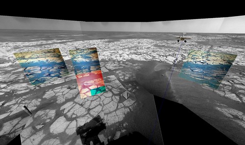
Sol 1709 and 1710 Polar comparison views with multiple coordinated cracks annotated:
Click to view attachment
-Mike
Full Version: yellow brick road to the south
Here's the Navcam QuickTime VR for sol 1710 (2.2 MB)
Suddenly we're deluged with images. I've updated the Sol 1709 Navcam QuickTime VR (2.6 MB) and the Sol 1710 Navcam QuickTime VR (3.1 MB).
And for you geology fans, here is where the Pancam images were taken before the sol 1710 drive:
(All thanks to the miracle of the Pancam tracking database, which seems to be working again.)
And for you geology fans, here is where the Pancam images were taken before the sol 1710 drive:
(All thanks to the miracle of the Pancam tracking database, which seems to be working again.)
Only another 10-12 days before conjunction. Are we gona stay on this Island for another month?
QUOTE (climber @ Nov 17 2008, 04:33 PM) 
When one do not want to cross dunes...
Ooo...(insuck breath)...that's not good.
Glad we're on solid pavement now.
QUOTE (Vultur @ Nov 15 2008, 08:38 PM)
These landscapes are really strange looking, eerie, desolate, yet oddly beautiful. The intricate pattern of cracks reminds me of dry flats on Earth.
On Earth, I would expect that white material to either be salt (NaCl) or gypsum. Any clue what that substance is on Mars?
QUOTE (Juramike @ Nov 17 2008, 04:21 PM)
Ooo...(insuck breath)...that's not good.
What's not good? They made it through. Crush the sands of peril with your mighty wheels, O juggernaut, and laugh the hearty laugh. These puny purgatoids are no match for Earth's finest!

Although those images do worry me a bit, there's something REALLY COOL about leaving those deep tracks. I know all of Mars is about as "off-road" as you can get, but it looks more dramatic that the leave no footprint pavement....
QUOTE (climber @ Nov 17 2008, 03:33 PM)
Yes, that picture shows. If it has a little more slope, Oppy won't be able to continue.
QUOTE (Juramike @ Nov 17 2008, 02:21 PM)
Ooo...(insuck breath)...that's not good.
Glad we're on solid pavement now.
Glad we're on solid pavement now.
These are tracks that are still good. When you see cleat marks that's good. When they start to disappear than it is a different matter. If the tie-down cleat marks (what Juramike calls star pattern) disappear, than you will see very little progress. If you look at Purgatory's Hazcams you will see a nice progression between one type (cleat marks) of tracks to the next (only tie-down cleat marks) to the final (clods of dirt). Tracks that are deep in soil also not necessarily are bad thing. It makes turning a bit more difficult (due to the stuck RF wheel) but still drivable.
Paolo
So cool! Some of the cracks in 'The Runway' are visible in 25 cm/pixel HiRise images!
Click to view attachment
All the indicated cracks are from "ground truth" images from Oppy. Colored cracks follow same color key as in Polar images above. Additional cracks are indicated in black are identified from Oppy Sol 1709 or Oppy 1710 images (using mhoward's VR tool). Green dotted line shows fredk's lighter pavement/darker pavement boundary.
(Is that little crater in the center with cracks radiating outwards?)
-Mike
Here's what lies to the S of Oppy's Sol 1710 position. More SW to NE cracks as seen by HiRise!
Click to view attachment
Wherever Oppy ends up, one of these might be visible!
-Mike
Click to view attachment
Wherever Oppy ends up, one of these might be visible!
-Mike
It's amazing when you realize that features visible in an orbiter image correlate with features right under the feet of our beloved rovers, isn't it? That synergy makes for some very exciting exploration, as well as accurate mapping. 
This was my favorite image in a recent update. A pancam subframe in L257 false color of the prominent ledge seen south of the sol 1707/9 position. This is an unaltered image that was automatically generated by Midnight Mars Browser. I was hoping for a closer view when we first saw it in the distance, a few sols earlier. While it is quite an obvious feature in this rover view, I couldn't convince myself it was apparent on theHiRise.
I enjoy the rapidly-paced roving, but it kills me to see so many nifty outcrops fading in the rear view mirror.
Click to view attachment
Here is a big view of "The Runway" and approximate orientation of some of the larger SW-NE cracks visible from HiRise in relation to Victoria Crater:
Click to view attachment
Some of the cracks appear to roughly line up with the Victoria Crater centroid. So they might could be associated (but not necessarily).
-Mike
Click to view attachment
Some of the cracks appear to roughly line up with the Victoria Crater centroid. So they might could be associated (but not necessarily).
-Mike
Today's drive was quite short, at least for this leg's standards: 8 meters. Testing something, perhaps?
Click to view attachment
Edited: I think here's the answer for the short drive. It's named "Santorini" and will probably be the subject of science during the occultation period.
Click to view attachment Click to view attachment
Click to view attachment
Edited: I think here's the answer for the short drive. It's named "Santorini" and will probably be the subject of science during the occultation period.
Click to view attachment Click to view attachment
QUOTE (CosmicRocker @ Nov 18 2008, 08:57 AM)
While it is quite an obvious feature in this rover view, I couldn't convince myself it was apparent on the HiRise.
I've identified the ledge in the hirise view (white arrow):
Click to view attachment
Notice the dark sand/dust(?) just north of the ledge. I suppose the lower (north) side of the ledge has been acting as a trap. I was glad that we avoided that area on the drive.
QUOTE (Tesheiner @ Nov 18 2008, 09:18 AM)
Edited: I think here's the answer for the short drive. It's named "Santorini" and will probably be the subject of science during the occultation period.
Good, the scientists have a cobble to play with for a couple of weeks. Maybe they will leave the drivers alone after that.
QUOTE (BrianL @ Nov 18 2008, 12:33 PM)
Good, the scientists have a cobble to play with for a couple of weeks. Maybe they will leave the drivers alone after that.
If that's the plan, I guess we have a good month before continuing the journey south.
QUOTE (BrianL @ Nov 18 2008, 06:33 PM)
Good, the scientists have a cobble to play with for a couple of weeks. Maybe they will leave the drivers alone after that.
Yeah ! Because Driving = Science at Endeavaour
----------------------------------
QUOTE
drive, drive, drive," said Squyres.
(The Planetary Society Rovers Update, Novmeber 2008)

QUOTE (centsworth_II @ Nov 18 2008, 06:53 PM)
If that's the plan, I guess we have a good month before continuing the journey south.
It's what I thought yesterday: "Only another 10-12 days before conjunction. Are we gona stay on this Island for another month?"
It's what Eduardo says: "I think here's the answer for the short drive. It's named "Santorini" and will probably be the subject of science during the occultation period"
For Rui/Ustrax: Any idea?
, hum, I mean idea, not map 
QUOTE (Tesheiner @ Nov 18 2008, 04:18 PM)
It's named "Santorini"
Any reason for this name?
I do not believe they think they've finaly found the Atlantide!
Not yet 
Sol 1709 drive direction mosaic:

Sol 1711 'survey' mosaic:

Both images link to the same blog entry.
James
Sol 1711 'survey' mosaic:
Both images link to the same blog entry.
James
Arm manoeuvers to get in touch with Santorini: http://qt.exploratorium.edu/mars/opportuni...cam/2008-11-18/
QUOTE (climber @ Nov 18 2008, 10:46 AM)
Any reason for this name?
I do not believe they think they've finaly found the Atlantide! Not yet
I do not believe they think they've finaly found the Atlantide!
Not yet Sqantorini as in the small island in the Mediterranean Sea. This will hopefully be the first serious IDD target after the Sol 1502 Joint 1 anomaly. Getting the IDD on this target will not be easy, but we will try to do our best. Conjunction is not too far away and want to maintain some margin in case something does not go as planned.
Paolo
QUOTE (RoverDriver @ Nov 18 2008, 09:55 PM)
SConjunction is not too far away and want to maintain some margin in case something does not go as planned.
Paolo
Paolo
Ok that makes sense ...
Thanks for the explanation
And some people believe that Santorini is where the mythical Atlantis was situated, I think that was what climber referred to. It certainly did explode in ancient times, a cataclysmic event that influenced a big part of the Eastern Mediterranean.
http://en.wikipedia.org/wiki/Santorini
"The island is the site of one of the largest volcanic eruptions the planet has ever seen: the Minoan eruption (sometimes called the Thera eruption), which occurred some 3,600 years ago at the height of the Minoan civilization. The eruption left a large caldera surrounded by volcanic ash deposits hundreds of feet deep and may have led indirectly to the collapse of the Minoan civilization on the island of Crete, 110 km (70 miles) to the south, through the creation of a gigantic tsunami. Another popular theory holds that the Thera eruption is the source of the legend of Atlantis."
QUOTE (Juramike @ Nov 18 2008, 11:02 AM)
Is that a fault?
http://qt.exploratorium.edu/mars/opportuni...B2P0733R0M1.JPG
http://qt.exploratorium.edu/mars/opportuni...B2P0733R0M1.JPG
Looks like a transform boundary to my untrained eye.
well maybe I can comment about this Santorini as I come from another mediterranean island - Malta -which also is considered by some archeologists as possibly having been part of Atlantis due to the numerous neolithic temples which date earlier than the pyramids in Egypt!And also is featured in Homers Odyssey as the place where Homer was cast away for 7 years under the spell of the nymph Calypso!!
Anyway,Santorini is a volcanic structure which erupted violently and I've read in some books,at this moment ACT OF God comes to mind and also featured in documentaries on Discovery Channel as having been the massive eruption at the time when Moses was leading his people out of Egypt...the column of fire they saw at night could have been the eruption of Santorini;the 10 punishments on Egypt some relate to the natural phenomena associated with this eruption as well as the parting of the waters at the sea of Reeds when the jews were crossing into the Sinai peninsula during their flight from Egypt could have resulted from a big tsunami which crashed into the egyptian coastline!
Anyway,Santorini is a volcanic structure which erupted violently and I've read in some books,at this moment ACT OF God comes to mind and also featured in documentaries on Discovery Channel as having been the massive eruption at the time when Moses was leading his people out of Egypt...the column of fire they saw at night could have been the eruption of Santorini;the 10 punishments on Egypt some relate to the natural phenomena associated with this eruption as well as the parting of the waters at the sea of Reeds when the jews were crossing into the Sinai peninsula during their flight from Egypt could have resulted from a big tsunami which crashed into the egyptian coastline!
One of the bigger SW-NE oriented cracks predicted from an earlier post shows up nicely from the Sol 1713 position!
Click to view attachment
-Mike
Click to view attachment
-Mike
Whoo-hoo! A puzzle!
HiRise views of Cracks and Faults (note subtle offsets visible even in HiRise imagery!):
Click to view attachment
Confirmed on the ground by Oppy Sol 1713 Navcam views of the same cracks and faults.
Same color scheme as HiRise image graphic):
Click to view attachment
-Mike
HiRise views of Cracks and Faults (note subtle offsets visible even in HiRise imagery!):
Click to view attachment
Confirmed on the ground by Oppy Sol 1713 Navcam views of the same cracks and faults.
Same color scheme as HiRise image graphic):
Click to view attachment
-Mike
Taking the cracks visible in Oppy's Navcam mosaic and seeing who cuts who (uncut one is the youngest):
Click to view attachment
The green fault is the youngest. The yellow-orange crack seems to be the oldest. (Not clear if red crack is associated with the yellow-orange crack or the green fault - the evidence is further to the SW or may be buried under a dune).
Putting the a possible story together, here is a proposed sequence of the cracks and faults in the SW view from Sol 1713:
Click to view attachment
1) Red-orange-yellow crack/fault forms
2) Blue-purple fault forms and cuts the orange-yellow crack
3) Green fault forms and cuts the the blue-purple crack/fault
-Mike
Click to view attachment
The green fault is the youngest. The yellow-orange crack seems to be the oldest. (Not clear if red crack is associated with the yellow-orange crack or the green fault - the evidence is further to the SW or may be buried under a dune).
Putting the a possible story together, here is a proposed sequence of the cracks and faults in the SW view from Sol 1713:
Click to view attachment
1) Red-orange-yellow crack/fault forms
2) Blue-purple fault forms and cuts the orange-yellow crack
3) Green fault forms and cuts the the blue-purple crack/fault
-Mike
Just wondering whether Santorini is the loose "rock-cobble" in front of us or the whole "Island in the Sand" we're on at this time.
Only the cobble, I would say. The observation named after Santorini is a "single shot" pointed right at the rock; it's not a mosaic of the whole area.
01713::p2588::21::6::6::0::0::2::14::pancam_santorini_L257R167
01713::p2588::21::6::6::0::0::2::14::pancam_santorini_L257R167
Proposed sequence of the crack and faults with image:
Click to view attachmentClick to view attachment
Click to view attachmentClick to view attachment
"Original" image of what the view SW might have looked like before faulting and shifting took place:
Click to view attachment
-Mike
Click to view attachment
-Mike
QUOTE (climber @ Nov 19 2008, 12:20 AM)
Just wondering whether Santorini is the loose "rock-cobble" in front of us or the whole "Island in the Sand" we're on at this time.
AFAIK it is just the cobble.
Paolo
I'm sorry, I can't hold this in any longer...
Every time I see the title of this thread, all I can think of is a bunch of little people popping up from behind the ripples, dressed like miners, singing "We represent the Hematite Guild!"
Sorry... we now take you back to your dry, serious thread...
-the other Doug
Every time I see the title of this thread, all I can think of is a bunch of little people popping up from behind the ripples, dressed like miners, singing "We represent the Hematite Guild!"
Sorry... we now take you back to your dry, serious thread...
-the other Doug
IDD's over Santorini: http://qt.exploratorium.edu/mars/opportuni...cam/2008-11-19/
Here's the Sol 1713-1714 Navcam QuickTime VR (3.4 MB). Looks like this is it for a few weeks.
QUOTE (mhoward @ Nov 19 2008, 04:33 PM)
Here's the Sol 1713-1714 Navcam QuickTime VR (3.4 MB). Looks like this is it for a few weeks.
Yep. It seems like the scenery will be the same until post-conjunction. I guess I will take a part-time job with UPS in the meantime. ;-)
Paolo
MSL won't take you on as a temp? 
QUOTE (RoverDriver @ Nov 18 2008, 02:55 PM)
Getting the IDD on this target will not be easy, but we will try to do our best.
Paolo
Paolo
not easy? looks like you got it on the first try
http://qt.exploratorium.edu/mars/opportuni...B2P1134R0M1.JPG
QUOTE (RoverDriver @ Nov 19 2008, 07:21 PM)
Yep. It seems like the scenery will be the same until post-conjunction. I guess I will take a part-time job with UPS in the meantime. ;-)
At 100 meters a day, I don't think they will keep you on for long.
QUOTE (RoverDriver @ Nov 20 2008, 02:21 AM)
I guess I will take a part-time job with UPS in the meantime. ;-)
Paolo
Paolo
There's a Right Front Weel to deliver up at Gusev...interested?
More "islands" to be spotted today (sol 1715): Crete, Corfu, and Sicily.
01715::p2590::21::24::24::0::0::2::50::pancam_crete_L7R1
01715::p2591::21::8::8::0::0::2::18::pancam_corfu_L7R1
01715::p2592::21::8::8::0::0::2::18::pancam_sicily_L7R1
01715::p2590::21::24::24::0::0::2::50::pancam_crete_L7R1
01715::p2591::21::8::8::0::0::2::18::pancam_corfu_L7R1
01715::p2592::21::8::8::0::0::2::18::pancam_sicily_L7R1
Being from the island of Malta,I would hope they consider naming one of the "islands" MALTA...having come close to naming others Sicily ,Corfu,Crete....maybe if someone in this blog who is influential on Naming places on MARS,should take this suggestion !!
This is a "lo-fi" version of our main content. To view the full version with more information, formatting and images, please click here.