Help - Search - Members - Calendar
Full Version: Mission: Hayabusa 2
Unmanned Spaceflight.com > Other Missions > Cometary and Asteroid Missions > Hayabusa2
Pages: 1, 2, 3, 4, 5, 6, 7, 8, 9, 10, 11, 12, 13, 14, 15, 16, 17, 18, 19, 20
Daniele_bianchino_Italy
I do not know if this question has already been done. I can not understand the temperature in Ryugu's color scale. What does 4000/-2000 mean? these are not C°. F. K.?
The site is unclear simply writes:" High temperatures on the asteroid reach 100°C, while the coldest regions sit at about room temperature. Temperatures also change depending on the solar distance of the asteroid".
http://www.hayabusa2.jaxa.jp/en/topics/20180907e/
fredk
The caption reads "The scale bar shows relative temperature (the values have no meaning)." So it sounds like this is some temperature-dependent signal (intensity at some wavelength?) that hasn't yet been (or won't or can't be) converted to temperature. You can perhaps very crudely estimate temperatures based on that stated range (ie, deepest red ~ 100 C, deepest blue ~ 20 C), but there's no guarantee that is accurate or that the colour scale is linearly proportional to temperature in between those limits.
mcmcmc
Unfortunately thermal cameras have no an absolute scale: they draw in blu the coldest thing they see and in white or red the hottest thing... but right in that moment! When the subject changes or move... blu is still the coldest point and whitethe hottest, but they can mean different absolute temperatures.
So in one image you could have blue=0°C and red/white=+100°C, but in another image you could have blue=-100°C and white=-50°C (different extreme values and different range).

I don't know how you can calibrate them, especially if you have no references with known temperatures in the image.
Gerald
Here is the most accurate description I found about the thermal infrared imager (TIR). See subsection 5.4 for the temperature accuracy.
The instrument is built on the basis of an uncooled NEC 320A bolometer.

Be aware, that these instruments usually measure brightness temperatures.
Hungry4info
Press Conference in 2.5 hours (as of the time of this post).
https://www.youtube.com/watch?v=zXXepYfsiQc
Marcin600
QUOTE (Hungry4info @ Oct 11 2018, 04:59 AM) *
Press Conference in 2.5 hours (as of the time of this post).
https://www.youtube.com/watch?v=zXXepYfsiQc


today's press conference pdf in japanese http://fanfun.jaxa.jp/jaxatv/files/20181011_hayabusa2.pdf.
There are no new pictures
abalone
Japan delays touchdown of Hayabusa2 probe on asteroid: official
http://www.spacedaily.com/m/reports/Japan_...ficial_999.html

JAXA project manager Yuichi Tsuda said they needed more time to prepare the landing as the latest data showed the asteroid surface was more rugged than expected.
mcaplinger
QUOTE (mcmcmc @ Oct 9 2018, 11:28 PM) *
I don't know how you can calibrate them...

Pretty much the same way you calibrate anything, you use calibrated blackbody sources of known temperatures and then you assume the camera stays stable over operating conditions, or you calibrate it over those conditions in ground testing.
pandaneko
I could not upload my translation all last two days. Screen just kept jittering. Anyway, some of the new things in the press briefing are
as follows:

p6

We were engaged in MASCOT seperation from 30 September to 4 October and MASCOT was successfully seperated on 3 October and
it landed on the asteroid and functioned for about 17 hours.

Rehearsal (again) for the 1st touch down (TD1-R1-A) will be conducted from 14 to 15 October.

p7 Operation outline

On 28 September we receivded in writing, from Dr Tra-MiHo, project manager of MASCOT, her order to seperate MASCOT from
the mothership.


As a result, on 2 Octber at 11:50 (JST) a command was sent to Hayabusa 2 to start descending and at 10:57:20 on 3 October
MASCOT was seperated at a height of 51m. We received from Dr Tra-MiHo at 04:30 on 4 October her declaration of the completion of
this mission.

MASCOT functined for about 17 hours and all instruments on board obtained data. The data was then sent to the team in Germany.
It has been confirmed that MASCOT did one hopping.

MASCOT operation was entirely conducted at the German end and about 40 people were involved at DLR and 5 people at CNES
supported this operation.

US support with DSN came at level 2 (redundant antenna plus maximum manpower support)

Received data will be used for touch down operation as well

p15

6 descending operations have been conducted by now. As a direct result of these operations following schedule has been agreed on.


TD1-R1-A(2nd TD rehearsal) on 14-15 October.
TD1-R3(3rd TD rehearsal) on 24-25 October.

Late November to December overall operation.

1st touch down after January 2019.


p17

TD1-R1 was made to equatorial zone, MINERVA-II northern hemisphere, and MASCOT middle lattitude area of southern
hemisphere. From these operations it is now known that H2 can be guided to +/-30 degrees from the equator and with an accuracy of
+/-10m down to the height of about 50m.

P18

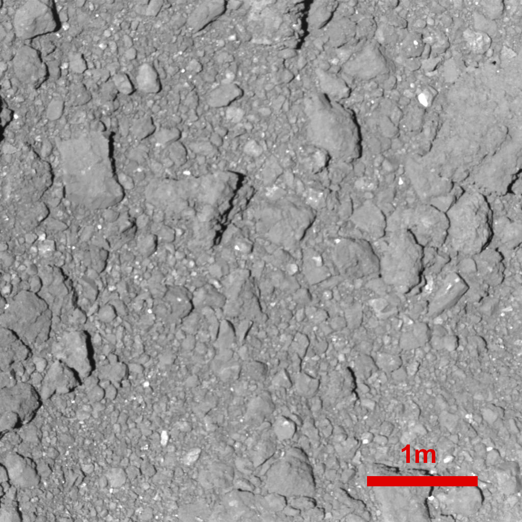
From observations we find that TD candidate areas (L08,L07,M04)are densely covered by boulders( larger than 50cm). Their
distribution has been obtained. TD areas are found to be very difficult to land with so many boulders.

P19

From the photos that have been taken by MINERVA and MASCOT Ryugu's surface is not that of a few boulders sitting here and there on
sandy ground, but it is rather that the ground itself is made up of boulders.

Some more to follow. P
pandaneko
Press briefing findings

p20

Touch down rehearsal and policy

Things that need confirmation

1. confirm that we can combat an extremely rough terrain.

2. confirm spacecraft behaviour at an extremely low altitude below 50m.

3. Confirm navigation precision below 50m via TD1-R1-A

4. cinfirm LRF properties via TD1-R1-A

5. Target markers tracking properties, if possible via TD1-R3 operation

※TM
in our earlier project plan target marker tracking was not part of it, but it was decided to add this operation in our new plan.

In addition we may also consider pin point touch down.

NB: Target marker tracking(TMT)

Markers are identified within photos and positions are reflected into orbt controling.

What is wanted in TD1-R1-A :

Confirmation of control precision.

LRF properties.

NB: with LRF only measurments will be taken and they are not immediately used for actual controling.

What is wanted in TD-R3:

Confirmation of control precision

Incorporate LRF measurments into control programme

If possible release target markers ™

P21

Rehearsals

14-15 October: TD1-R1-A (2nd touch down rehearsal)

24-25 October: TD1-R3 (3rd touch down rehearsal)

Press briefings

16:00 23 October
11:00 8 November

End of this briefing

P


mcmcmc
Just in time for next mission, here it is a fully functional simulator:
https://programmi.000webhostapp.com/hayabus...simulator3.html


Changes:
Added speed to realtime data
Added speed to history chart
Moved/resized ryugu/H2 schematic
Added decimals to rovers images sizes in ONC
(Invisible: added speed data to history log)


Plans for the future:
Add a box with a zoom of the chart on last 72 hours.
Add a box with a zoom of the chart between 0 and 500 meters (or configurable).
Add the schedule for next missions.
Add playback function for previous missions; in the meantime you can use separate pages to perform a replay of MINERVA release mission and MASCOT release mission. Players are still in beta so pay attention not to move mouse over images until they are fully loaded or they will stop loading.


Next missions:
14-15 October: TD1-R1-A (2nd touch down rehearsal)
24-25 October: TD1-R3 (3rd touch down rehearsal)

Next press conferences:
23 October-16:00 JST (07:00GMT)
8 November - 11:00 JST (02:00 GMT)
pandaneko
I was watching the last and latest press briefing once again and I noticed that my earlier translation needs improvements.

TD1-R1-A: This is exactly the same operation as the very first rehearsal, which was aborted due to LIDAR not feeling very well.They are
will be trying to repeat the same operation.

TD1-R3 : This is a new rehearsal based on the findings of TD1-R1A (JAXA said that this operation could be named as TD-R2).

During Late November to December H2 will be hidden behind the Sun, so other operations will be running.

And, by far the most important is that the first touch down operation will be delayed into the latter half of January 2019, simply
because the surface is so violently rocky.

P
Therion
There is new press release by DLR with some new images and details about MASCOT landing:

Numerous boulders, many rocks, no dust: MASCOT's zigzag course across the asteroid Ryugu


mcmcmc: That is very nice simulator! Thank you for that : )
yoichi
https://twitter.com/haya2e_jaxa/status/1051693960429633537
HAYABUSA2@JAXA‏ @haya2e_jaxa
The material from the press briefing that was held on October 11 is now available on the project website. Content includes:
(1) Report on the separation of MASCOT,
(2) Touchdown rehearsals and plans.
http://www.hayabusa2.jaxa.jp/en/enjoy/mate...1011_ver7en.pdf
13:39 - 2018年10月15日
mcmcmc
Theorical MASCOT size in ONC-T camera crossed 1 pixel, so it could be visible from now on, at least as a bright dot where no bright dots were visible before.
MINERVA rovers still around 0.6 pixel.
But please note that most of the released images are form ONC-W, which has 1/10 resolution of ONC-T.
mcmcmc
Big real time chart:
https://programmi.000webhostapp.com/hayabus...aya2-dates.html

Big real time chart with speed:
https://programmi.000webhostapp.com/hayabus...dates-test.html
mcmcmc
TD1-R1a mission ended, H2 now raising again.

OrbitrapInSpace
QUOTE (mcmcmc @ Oct 15 2018, 08:40 AM) *
Theorical MASCOT size in ONC-T camera crossed 1 pixel, so it could be visible from now on, at least as a bright dot where no bright dots were visible before.
MINERVA rovers still around 0.6 pixel.
But please note that most of the released images are form ONC-W, which has 1/10 resolution of ONC-T.


There is a bright point on these images, north hemisphere, so cannot be Mascot...

http://www.hayabusa2.jaxa.jp/galleries/onc...01810150957.jpg
http://www.hayabusa2.jaxa.jp/galleries/onc...01810151026.jpg
http://www.hayabusa2.jaxa.jp/galleries/onc...01810151055.jpg
http://www.hayabusa2.jaxa.jp/galleries/onc...01810151123.jpg
mcmcmc
QUOTE (OrbitrapInSpace @ Oct 15 2018, 08:51 PM) *


is MASCOT final resting position known?
Hungry4info
The bright dot was seen before the MASCOT deployment. Link.
Phil Stooke
A little something I've been working on...

As time permits I will label the grids and add landing sites, feature names etc. This is a composite of Roman's map and some data from JAXA, but as new material comes out i will improve it. The map projection is an azimuthal equidistant projection modified slightly to represent the familiar diamond-shaped cross-section of Ryugu.

Phil

Click to view attachment
Phil Stooke
Here is a first map showing the information I have at the moment. The MINERVA location is shown as an ellipse. If anyone has more information on a specific location I would be interested to see it. Are there any other names for features? I haven't seen any.

I will update this as we go.

Phil

Click to view attachment
vikingmars
QUOTE (Phil Stooke @ Oct 17 2018, 07:00 PM) *
Here is a first map showing the information I have at the moment. The MINERVA location is shown as an ellipse. If anyone has more information on a specific location I would be interested to see it. Are there any other names for features? I haven't seen any.
I will update this as we go. Phil


Phil, you are the best wheel.gif wheel.gif wheel.gif wheel.gif as usual smile.gif
John Moore
What can one say...Phil
mcmcmc
QUOTE (Phil Stooke @ Oct 17 2018, 05:00 PM) *
Here is a first map showing the information I have at the moment. The MINERVA location is shown as an ellipse. If anyone has more information on a specific location I would be interested to see it. Are there any other names for features? I haven't seen any.

I will update this as we go.

Phil

Click to view attachment

Wherer did JAXA publish information about Lat0-Lon0 point?

About the 3d model, did anybody successfully build an high-res one, now that hundreds of images are available? I am collecting all of them:
http://programmi.000webhostapp.com/hayabus...ayer-index.html
paraisosdelsistemasolar
QUOTE (mcmcmc @ Oct 19 2018, 07:53 AM) *
Wherer did JAXA publish information about Lat0-Lon0 point?

About the 3d model, did anybody successfully build an high-res one, now that hundreds of images are available? I am collecting all of them:
http://programmi.000webhostapp.com/hayabus...ayer-index.html


I have tried with the latest available images, but no luck creating a good 3D model, at least not with the software I'm using sad.gif
Phil Stooke
"Where did JAXA publish information about Lat0-Lon0 point?"

It's in this JAXA press conference PDF:


http://global.jaxa.jp/projects/sat/hayabus...ss20180719e.pdf

And of course, it is also illustrated in every JAXA map since then which includes a coordinate grid.


Phil
Tom Dahl
A 3D digital shape model of Ryugu has been created by Mattias Malmer, and he has physically printed a copy as well. (I hope he doesn't mind me sharing this information.)
Phil Stooke
No new details, but this version of the map has an improved base image. The positional control is slightly better as well, so the sites are shifted slightly to match the modified base.

Phil

Click to view attachment
mcmcmc
Descent started:

https://programmi.000webhostapp.com/hayabus...simulator3.html

Detailed schedule of the mission is now online: http://www.hayabusa2.jaxa.jp/en/topics/201...D1-R3_Schedule/
This time it won't be just a "almost-touch & go", but the spacecraft will stay at 20m altitude for around 20 minutes, from 02:30 to 02:50 UTC.
Hungry4info
The Hayabusa 2 twitter feed reports that the target marker was released.
QUOTE
[TD1-R3] October 25 at 12:40 JST: Communication with the high-gain antenna (HGA) has resumed & telemetry on the status of the spacecraft is confirmed. The spacecraft is normal. The target marker is confirmed to be separated. The spacecraft is now at an altitude of more than 1200m

As is typically the case whenever anything interesting happens, the live image page has stopped updating.
mcmcmc
QUOTE (Hungry4info @ Oct 25 2018, 05:17 AM) *
The Hayabusa 2 twitter feed reports that the target marker was released.

As is typically the case whenever anything interesting happens, the live image page has stopped updating.

Twitter feed reveals that at lowest altitude even the live telemetries were not available due to usage of low-gain antenna, not to mention the high-speed-transmission-demanding images:

QUOTE
[TD1-R3] October 25, 12:06 JST: Confirmation that the spacecraft has begun to rise. Near the lowest point, the low-gain antenna (LGA) were in use & telemetry wasn’t possible. The spacecraft velocity was monitored with Doppler Data. Low altitude circumstances to be confirmed later

https://twitter.com/haya2e_jaxa/status/1055301107495227392

Indeed this resulted in a mess in the live telemetries used by JAXA simulator, resulting in this messed up chart (I cleaned up the calculated speeds, but I can't do anything about wrong readings from LIDAR):

Explorer1
An image of the marker on the surface is here: https://twitter.com/haya2e_jaxa/status/1055421132784824320

To think... my name (and hopefully a lot of UMSFers' names are on board that little speck..

AAS Press conference here in a few hours (12:00 EST): https://aas.org/media-press/aas-press-conference-webcasts
alan
Big boulder on Ryuga's pole is named Otohime.

https://twitter.com/sharponlooker/status/1055499790463746048
Phil Stooke
Map update! Several changes including the boulder name.

Phil

Click to view attachment
Paolo
some amazing selfies of the sampler horn taken by the crowdfunded small monitor camera
http://www.hayabusa2.jaxa.jp/en/topics/20181026e_CAM-H/
yoichi
http://www.hayabusa2.jaxa.jp/en/topics/201...6e_TD1R1A_ONCT/
The highest resolution image of Ryugu

charborob
Animated sequence of 41 images taken during the second touchdown rehearsal.
fredk
QUOTE (yoichi @ Oct 26 2018, 07:29 AM) *
The highest resolution image of Ryugu

...not including MINERVA and MASCOT of course.
Jackbauer
Asteroid Ryugu imaged at High resolution

https://aas.org/files/resources/dps50_lucille_le_corre.pdf
Paolo
very long paper on Hayabusa's cameras:
Updated Inflight Calibration of Hayabusa2's Optical Navigation Camera (ONC) for Scientific Observations during the Cruise Phase

QUOTE
The Optical Navigation Camera (ONC-T, ONC-W1, ONC-W2) onboard Hayabusa2 are also being used for scientific observations of the mission target, C-complex asteroid 162173 Ryugu. Science observations and analyses require rigorous instrument calibration. In order to meet this requirement, we have conducted extensive inflight observations during the 3.5 years of cruise after the launch of Hayabusa2 on 3 December 2014. In addition to the first inflight calibrations by Suzuki et al. (2018), we conducted an additional series of calibrations, including read-out smear, electronic-interference noise, bias, dark current, hot pixels, sensitivity, linearity, flat-field, and stray light measurements for the ONC. Moreover, the calibrations, especially flat-fields and sensitivities, of ONC-W1 and -W2 are updated for the analysis of the low-altitude (i.e., high-resolution) observations, such as the gravity measurement, touchdowns, and the descents for MASCOT and MINERVA-II payload releases. The radiometric calibration for ONC-T is also updated in this study based on star and Moon observations. Our updated inflight sensitivity measurements suggest the accuracy of the absolute radiometric calibration contains less than 1.8% error for the ul-, b-, v-, Na-, w-, and x-bands based on star calibration observations and ~5% for the p-band based on lunar calibration observations. The radiance spectra of the Moon, Jupiter, and Saturn from the ONC-T show good agreement with the spacecraft-based observations of the Moon from SP/SELENE and WAC/LROC and with ground-based telescopic observations for Jupiter and Saturn.
mcmcmc
Missions profiles analyses:


Annotated:


Details for TD1-R3:


Recorded telemetries up to now (with additional cleaned up data from noise and errors):
https://programmi.000webhostapp.com/hayabus...1-20181027).txt
https://programmi.000webhostapp.com/hayabus...181027)-ita.txt (decimal commas)


3d model of terrain from TD1-R1A imageset:
https://sketchfab.com/models/a8e3cee4ea9444...4fe1a4f2eef58ed
Paolo
are you sure that the descent was unscheduled? or was it just unnannounced?
mcmcmc
QUOTE (Paolo @ Oct 29 2018, 09:35 AM) *
are you sure that the descent was unscheduled? or was it just unnannounced?


It's not in the public schedule nor in the twitter feed; of course I don't know about private schedules.
Weywot
Not sure if that was posted before, but there is a very nice Space Science Review Issue about Hayabusa2 from July 2017. It wasn't free at the time I looked at it, but not no longer behind a pay wall. It's a lot of information, several very detailed papers about all the instruments and components. I especially enjoyed the papers about the impactor opration and the deployable camera.

Must read!

https://link.springer.com/journal/11214/208/1/page/1

Edit: hmm, following the link I posted and not the the google link that brought me there, it seems the issue is still behind the paywall. :-( The google link somewhat brought me behind the wall and I can access all the papers. Which is this one: https://link.springer.com/article/10.1007/s11214-017-0338-8 and then click on the issue link to go back to the overview.
mcmcmc
QUOTE (Paolo @ Oct 29 2018, 09:35 AM) *
are you sure that the descent was unscheduled? or was it just unnannounced?

New mission now confirmed by twitter , but telemetries are still not regular:
https://twitter.com/haya2_jaxa/status/1056838918694297602

"Tomorrow" in Japan already started at 15:00 UTC.

Last recorded altitude was 11332m, descending at 4 cm/s at 07:14 UTC Earth time (but uploaded to web at 17:30); 12 hours elapsed, which should mean 1728m lower, hence lower than 10000m. Target is 5000m.
Unfortunately my telemetry logger was not working for several hours due to a bug.

mcmcmc
This version of my chart is still in beta but already quite usable: you can't yet select the data period, but you can change vertical scale and reference dates (telemetries use three dates: onboard, received and uploaded (to web) ).

https://programmi.000webhostapp.com/hayabus...dates-5000.html
This is a "lo-fi" version of our main content. To view the full version with more information, formatting and images, please click here.
Invision Power Board © 2001-2024 Invision Power Services, Inc.