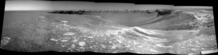
This first try shows a small Opportunity approaching Cape Verde on Sol 957.
I used James' great colorization pan 'Cape Verde from Duck Bay' (Homepage). Thanks James!
Now five sols later ...
Full Version: Cape Verde
The scale of this place continues to confuse me. I thought the cliffs were much bigger than the scale you are implying, but I've done no analysis to back this up!
Aberdeenastro
Aberdeenastro
I know what you mean. Back in Eagle crater, I first thought Opportunity was looking at a huge cliff off in the distance.

I believe it's been agreed that the famous "Mystery Men" provide a good sense of scale here...
Click to view attachment
(edit of larger image which can be found... oh... somewhere... don't have time to look! Sorry!)
Click to view attachment
(edit of larger image which can be found... oh... somewhere... don't have time to look! Sorry!)
Hi,
Wow, Mystery Man is back. Hurray!
So, here is the Sol 956 navcam panorama, build with Autostitch and MMB. This software is very good to make antivigneting and gain compensation (thanks to Mhoward ).
).
Wow, Mystery Man is back. Hurray!
So, here is the Sol 956 navcam panorama, build with Autostitch and MMB. This software is very good to make antivigneting and gain compensation (thanks to Mhoward
).
I too thought it was a huge cliff, and was a bit dissapointed when it turned out to be a few cm tall. Endurance made up for that though, and now we have Victoria and maybe later some part of Big Crater and its rim.
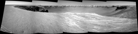
Another view of Victoria.
Taken with the L0 navcam on Sol 957.
jvandriel
Taken with the L0 navcam on Sol 957.
jvandriel
Here is the view in the drive direction.
Taken with the L7 pancam on Sol 957.
jvandriel
Taken with the L7 pancam on Sol 957.
jvandriel
Thanks Ant103 and jvandriel for those amazing panoramas. I can't stop looking at them. However, the more I look at them the more I think that the tip of Cape Verde is a treacherous place to be. The Beacon area looks much safer.
Aberdeenastro
(formerly known as Castor)
Aberdeenastro
(formerly known as Castor)
QUOTE (Ant103 @ Oct 4 2006, 03:53 PM) 
Hi,
Wow, Mystery Man is back. Hurray!
So, here is the Sol 956 navcam panorama, build with Autostitch and MMB. This software is very good to make antivigneting and gain compensation (thanks to Mhoward).
Wow, Mystery Man is back. Hurray!
So, here is the Sol 956 navcam panorama, build with Autostitch and MMB. This software is very good to make antivigneting and gain compensation (thanks to Mhoward
).Wow, impressive ponorama !
I too have been trying to use Micheal's MMB viewer lately but didn't succeed in exporting the
luminance corrected images for later use in panorama software (but I must admit that I have not spent
much time reading the docs yet)
How did you do the trick ?
Also, how did you manage to get the level horizon in the panorama ? (autostich usually produces
uneven horizon at the stitching seams and it's very cumbersome to find the right "greek" orientation parameters psi,phi....)
Isn't there also a special feature in MMB that takes JPL metadata in order to correct the exact rover orientation ... would it be possible to use this for the Autostich orientation parameters ?
QUOTE (jvandriel @ Oct 4 2006, 04:16 PM)
Here is the view in the drive direction.
Given the concerns already raised here and on another thread I hope they don't really drive too much on that direction.

The Rover drivers know what they are doing. Remember even the tilt paramter of say 30 degrees will stop the rover dead in its tracks. Cabo Verde is not a 90 degree drop off by any means, infact I don't think any of the cliffs are, they all seem to have a slope then a drop. They also have several other s/w parameters to stop a rover driving over a cliff.
Tesheiner.
Nirgal,
for a good as possible match at the seams in the Sol 957 navcam pano I used the
following parameters:
Matching Options:
Sift image:
Min dim ( pixels ): 4400
Ransac Parameters:
Alpha: 3
Beta: 0.1
Max Iterations: 4500
With the Manual Orientation parameters Phi and Psi you can level and straighten the Horizon.
This is most of the time only a problem with the navcam images.
The pancam panoramas are much better.
jvandriel
QUOTE (jvandriel @ Oct 4 2006, 04:55 PM)
Un-needed quote removed - please remember not to quote when replying - it'd save us admins a lot of time better spend on playing with the imagery 
jvandriel, Thanks a lot for giving the detail info about your settings ... greatly appreciated
-> just moved the thread over to the image-tech-forum
For Nirgal : I discover the method few weeks ago. To have the images corrected for the pan, go into "File > Advandced > Export Pan Images". After, choose the directory and "export".
For the horizon, when it is visible (so, at Meridiani, you often see the horizon...), I take the first image of the pano (the very first at the left) and I calculate the inclination of it. And in Autostitch, I put the inclination number in the "psi" parameter. After, you have to adjust the other parameter if it's necessary (phi for curve the whole pano, theta for bend the pano around the first pic).
This the way I proceed but, some times, by seeing the individual pictures in the finished pano, the horizon is not plane.
QUOTE (Ant103 @ Oct 4 2006, 03:14 PM)
... "File > Advandced > Export Pan Images".
... For the horizon, when it is visible (so, at Meridiani, you often see the horizon...), I take the first image of the pano (the very first at the left) and I calculate the inclination of it. And in Autostitch, I put the inclination number in the "psi" parameter. After, you have to adjust the other parameter if it's necessary (phi for curve the whole pano, theta for bend the pano around the first pic). ...
... For the horizon, when it is visible (so, at Meridiani, you often see the horizon...), I take the first image of the pano (the very first at the left) and I calculate the inclination of it. And in Autostitch, I put the inclination number in the "psi" parameter. After, you have to adjust the other parameter if it's necessary (phi for curve the whole pano, theta for bend the pano around the first pic). ...
FYI, an alternative to using Autostitch at all would be to use Hugin, a free open-source alternative to PTGui, with the mmb.pts project file that gets generated by that option now (in 1.5.1). James pointed this out to me. Of course you could also use PTGui, which is great, but it's not free.
QUOTE (Ant103 @ Oct 4 2006, 01:53 PM)
So, here is the Sol 956 navcam panorama, build with Autostitch and MMB. This software is very good to make antivigneting and gain compensation (thanks to Mhoward ).
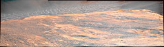
).Nice stitch, Ant... I made this processed and coulored version (is reduced and slightly cropped from original).
Regarding Autostitch, remember to share additional information in this thread where Jvandriel already supplied very useful tips;
http://www.unmannedspaceflight.com/index.p...c=1071&st=0
Nico
http://www.unmannedspaceflight.com/index.p...c=1071&st=0
Nico
QUOTE
The navcams and pancams make it clear we are headed to the tip of Verde.
The only question that remains is how close dare they get to the "edge"? ph34r.gif
PS - I guess this discussion should go to the Verde thread...
The only question that remains is how close dare they get to the "edge"? ph34r.gif
PS - I guess this discussion should go to the Verde thread...
My guess is we are going right where the Pancams are...
It should be one fantastic view.
New pancams of the dunefield are L2,7 so some pseudo-color is doable..I've been playing with them a bit but I'm too tired to finish it so I'm off to bed.
Somebody up to some work on those? Marco? Horton? anyone?
Nico
Somebody up to some work on those? Marco? Horton? anyone?
Nico
L27 1x4 -- 9 meters from edge!
Thanks for that, Horton. The L7 channel was heavily compressed, so colours are a little blocky. Can't wait for the big pan!
A Oppy collection is opened.
Sol 958 ...
Sol 958 ...
One of the reasons cited for going to Cape Verde was to do some close-up work on some rocks. The latest navcams and pancams do not seem to show any accessible rock in the vicinity. I wonder if they will now head up towards the Beacon where there does appear to be outcrop and might give a better view?
Aberdeenastro
(formerly known as Castor)
Aberdeenastro
(formerly known as Castor)
What's going on here? 
CODE
959 p2589.16 0 0 0 0 0 0 pancam_left_rear_wheel_pos_L257
959 p2590.16 0 0 0 0 0 0 pancam_right_rear_wheel_pos_L257
959 p2590.16 0 0 0 0 0 0 pancam_right_rear_wheel_pos_L257
Maybe they are taking a picture of the tracks now, for comparision after solar conjunction, if Oppy is indeed parked at THE conjuction position for the next 3 or 4 weeks.
opportunity? what is opportunity?! ...this should be called cliffhanger!
QUOTE (hortonheardawho @ Oct 5 2006, 12:17 AM)
L27 1x4 -- 9 meters from edge!
I wonder if are they really planning to go that far.

Here is an exercise showing the current horizontal fov (i.e. far rim not blocked by either the beacon or Cabo Frio) and an estimation of the fov if the rover drives forward another 5m. The view won't change too much, perhaps another cape will be visible to the north but nothing more.
Off course, the big change will be in the vertical fov because the center dune field should be completely visible.
Click to view attachment
From a geological perspective, it would be very helpful to see the cliff on the south side of the Beacon. Then we'd be able to compare it to the exposures that were imaged on the south side of Cape Verde and the north side of Cabo Frio. That little bit of extra distance might be all that we need.
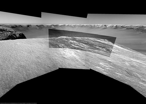
Here is the Sol 958 Navcam pan, with the same method of my last (MMB & Autostitch) :
I can't believe that the team want to stay here for the solar conjonction, the view should be great from Beacon ...
I can't believe that the team want to stay here for the solar conjonction, the view should be great from Beacon
...
Beacon sounds good too; I'd really like to get some distance so that the petrified liz@rd doesn't crawl up and start sunning himself on Oppy's solar panels.
Seriously, before moving on, I hope they take the extra few meters drive to the edge and get a full pan of the Beacon's southern face. If we don't get it here, it will be a long time before we get another, urm, "opportunity."
Seriously, before moving on, I hope they take the extra few meters drive to the edge and get a full pan of the Beacon's southern face. If we don't get it here, it will be a long time before we get another, urm, "opportunity."
Now that's a conundrum: do we want to see the beacon or do we want to sit on the beacon? - I have the feeling we will have a lot of questions like that in the coming months. Which is not a bad situation to be in...

Indeed It looks she stands rather close to the north side of Cabo Verde's egde, tztz 
One Rover width (wheel to wheel) between maybe, but probably more.
No slip so far http://nasa.exploratorium.edu/mars/opportu...POP1311R0M1.JPG
One Rover width (wheel to wheel) between maybe, but probably more.
No slip so far
http://nasa.exploratorium.edu/mars/opportu...POP1311R0M1.JPG
And rock for IDD
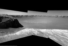
Sol 959 100-degree perspective view:
QUOTE (Stu @ Oct 5 2006, 07:42 PM)
Where IS everyone??? I thought there'd be images and mosaics flying in all directions tonight! 
That's the BEACON over there!!! We've talked about it for all these months, and we're here!!!
Maybe everyone's waiting until they release that pic of Oppy standing on the edge of VC as taken by MRO, at tomorrow's Media Briefing... (if that's what it is...? Wouldn't it be brilliant if it was an image sequence, with three frames, #1 showing one of the MER's being approached by a dust devil, looking all dirty and grungy, then #2 the rover enveloped by the dust, and #3 reappearing all shiny and new again! )
)
That's the BEACON over there!!! We've talked about it for all these months, and we're here!!!
Maybe everyone's waiting until they release that pic of Oppy standing on the edge of VC as taken by MRO, at tomorrow's Media Briefing... (if that's what it is...? Wouldn't it be brilliant if it was an image sequence, with three frames, #1 showing one of the MER's being approached by a dust devil, looking all dirty and grungy, then #2 the rover enveloped by the dust, and #3 reappearing all shiny and new again!
)I'm here Stu! A bit drunk (national holiday...) but here...
This, for me, is the boundary...Oppy is, from now on, the Earth's embassy to something unbleviable!...
I'm drooling...drooling...
And if my desire was in a Cape Verde egress, now...I don't how that cape will be named but that's the way! Totally the way...Sorry but this are the emotions writing...
I WANT to go down there!!!
Am I imagining things or is the Beacon 'Cabo' the only one that shows uplift rather than sag? Does this suggest something fascinating about the underlying structure, or is it just that a fragment of an upper 'evaporite' unit survives atop Beacon, and is lost everywhere else?
stunning...quite a parking spot!
QUOTE (ustrax @ Oct 5 2006, 09:11 PM)
I'm here Stu! A bit drunk (national holiday...) but here...
And if my desire was in a Cape Verde egress, now...I don't how that cape will be named but that's the way!
And if my desire was in a Cape Verde egress, now...I don't how that cape will be named but that's the way!
Only a bit drunk, Eh?
Did I just hear you say "Cape"?
Happy national holiday, Ustrax!
A bit bit...
That would be my Valley Without Peril in between...
The perfect egress!
It's the Republic's Triomph...Not my kind of holiday...But...Hey...It's a free day anyway...
That would be my Valley Without Peril in between...
The perfect egress!
It's the Republic's Triomph...Not my kind of holiday...But...Hey...It's a free day anyway...
Approximate location after tosols drive:
Click to view attachment
We're still 8 metres or so from the visible tip in that image, but we're much closer, only 3 metres or so, from the closest part of the "edge", which is more directly to our east (ie towards the "back" of Verde in that image). (This is according to AlgorimancerPG on the navcams).
I'm surprised that such a big part of the crater floor is smooth surface. I had the impression much more of it was covered by dunes, but it looks to me as if there's a hard nicely-packed smooth surface for driving around on the "inside" track, going from cape to cape... Well, we'll see.
Oh yes, BTW. I am happy that the dilemma was solved, and that we chose to look AT the beacon instead of sitting on it. Holy smoking rock wall!
Oh yes, BTW. I am happy that the dilemma was solved, and that we chose to look AT the beacon instead of sitting on it. Holy smoking rock wall!
Awesome view indeed! The entire dunefield visible...what a sight.
And again perfect pans from Indian, a striking perspective projection by Michael...
Life is good
And now I'm off to bed since I can't stand the wait for that press release
Nico
And again perfect pans from Indian, a striking perspective projection by Michael...
Life is good
And now I'm off to bed since I can't stand the wait for that press release
Nico
QUOTE (Stu @ Oct 5 2006, 10:49 AM)
Um, don't you mean CLINK?
And I am most certainly here... though my excitement is tempered that I will soon have 2 weeks "cold turkey" to deal with....
QUOTE (lyford @ Oct 5 2006, 08:29 PM)
Um, don't you mean CLINK? :
No, I meant "chink"... only got little bitty coins right now, nothing heavy enough to make a "clink"
QUOTE (RedSky @ Oct 5 2006, 07:54 PM)
Hey, how about a "mystery man" standing down on the floor among the dunes. The floor seems so close from here, but I'm sure it quite a ways...
I think once again there's a mini-horizon at the entrance of the bay with an unseen steeper slope beyond that leading down to the dunefield.
This is a "lo-fi" version of our main content. To view the full version with more information, formatting and images, please click here.