djellison
Sep 28 2006, 03:15 PM
Now yes - while it's fair to say we have arrived at the rim of Vic - the rule were that the 'arrival' date would be the sol at which the rover arrives at the point from which the mother-of-all-pans is taken... so we're not there yet. (i.e. We'll probably take photos when we arrive in Valencia on Sat PM - but personally, I wont feel I've arrived till the following morning when I have a look out the window....and you're right Fred - it's that FIRST big MOAP that is the important one )
But that doesn't mean we can't have a new thread

Doug
Indian3000
Sep 28 2006, 03:22 PM
fredk
Sep 28 2006, 03:26 PM
Beautiful pans, Doug! But I think it should be "the first of the mother-of-all-pans"! We'll have dramatically different views from every cape/bay, and I'm sure we'll do many pans from the rim!
Stu
Sep 28 2006, 03:45 PM
Couldn't resist it... lens flare and all!
 Click to view attachment
gregp1962
Sep 28 2006, 03:46 PM
WOW!!
To me, it totally feels like we've arrived, Tosol!!!
fredk
Sep 28 2006, 03:46 PM
Well, someone's making a fortune off what I'm putting in the swear box!

Like I said yesterday:
topography!!! I just love that we have to now worry about completely new things that really neither rover has had to before, certainly not to this degree. As we've said already, there's the sun/communications link visibility from near the vicinity of a cliff. With todays images, another one occurs to me: We have to be careful about
what time of day we image cliff faces - large areas of Capes Frio and Verde are in deep shadow in these images!
Doug, we need a drool smily!
mhoward
Sep 28 2006, 03:48 PM
Wow.

Be sure to click the link to "Original" size for the full effect...
Here is
the Sol 952 Navcam equirectangular if someone wants to make a wild polar...
diane
Sep 28 2006, 03:50 PM
QUOTE (fredk @ Sep 28 2006, 11:26 AM)

Beautiful pans, Doug! But I think it should be "the first of the mother-of-all-pans"! We'll have dramatically different views from every cape/bay, and I'm sure we'll do many pans from the rim!
That would be the mother-in-law-of-all-pans, followed by the maternal- and paternal- grandmother-of-all-pans, followed by the fairy-godmother-of-all-pans... Sofi Crater will probably have to make do with a stepmother-of-all-pans.
Rakhir
Sep 28 2006, 03:54 PM
QUOTE (gregp1962 @ Sep 28 2006, 05:46 PM)
WOW!!
To me, it totally feels like we've arrived, Tosol!!!
Same feeling here
-- Rakhir
Nix
Sep 28 2006, 03:54 PM
Oh man!! These images are freaking me out

Nico
djellison
Sep 28 2006, 03:55 PM
QUOTE (mhoward @ Sep 28 2006, 04:48 PM)
a wild polar...
What we thought might be 2x2's are obviously going to be those 2 4x1's in L257.... for planning ( i.e. highest res terrain mesh ) the L7/R1's came down first, and if there's another UHF pass today, the 2's and 5's might come down....pretty
Doug
Bill Harris
Sep 28 2006, 03:55 PM
What wonderful outcrops and active erosional features. I'm all a'quiver with the first views of the Victoria rim and capes and bays. Looking at the surface of Duck Bay it does look passable for an initial toe-dip. I'm almost giddy in anticipation over the first L257's we'll be getting in the next couple of Sols.
--Bill
Aberdeenastro
Sep 28 2006, 03:59 PM
From here Cabo Frio looks a doddle and would be my choice for the MOA pans. Cape Verde is probably OK, but has that slope towards the crater. I'd hate for us to slip down there....
Castor
Indian3000
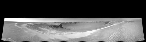
Sep 28 2006, 04:11 PM
vertical projection 1cm/pix
Click to view attachment
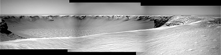
jvandriel
Sep 28 2006, 04:24 PM
Here is just a part of the Victoria panorama.
Taken with the L7 pancam.
It reminds me of the walls of the Grand Canyon.
jvandriel
Ant103
Sep 28 2006, 04:29 PM
Let me just finsh to take my eyes and put in their orbits...

One second...
Okay guys.
There is a [censored] view of Victoria. It's so... incredible!
Incredible, amazing, astounding are the good words!
HAIL VICTORIA!
So, my own images about that :
Sol 950
Sol 951
And many resolutions :
http://www.astrosurf.com/merimages/Images_...06.html#Sol_951Incredible...

jvandriel
Sep 28 2006, 04:40 PM
Here is the other part.
Taken with the L7 pancam.
jvandriel
Nix
Sep 28 2006, 04:44 PM
woaw (again), a first mosaic, I'm actually enjoying these views too much to make mosaics any faster

Nico
WindyT
Sep 28 2006, 04:52 PM
I didn't want to make a whole new thread about this, but to me, now comes a very obvious question:
Which outcrop shows the deepest stratigraphy in this crater?
It's a little early, but outside of Frio (P4) and Verde(A1) and B2(not yet imaged?) there's also the puny wall that is at the base of F2 that could be wall or vertical slump block next to the larger slump block.
karl
Sep 28 2006, 04:52 PM
QUOTE (Bill Harris @ Sep 28 2006, 10:55 AM)
What wonderful outcrops and active erosional features. I'm all a'quiver with the first views of the Victoria rim and capes and bays. Looking at the surface of Duck Bay it does look passable for an initial toe-dip. I'm almost giddy in anticipation over the first L257's we'll be getting in the next couple of Sols.
--Bill
Click to view attachmentThe surface of the bay may be navigable, but getting over the dune along the edge might be tricky, at least where the rover currently is parked. It looks to be shorter as one goes to the right along the edge of the bay towards the cape and is potentially navigable there. It is interesting how the dune bridges a gully extending up from the bay. Being near the center of the bay, I would guess the prevailing winds make the dune highest near where Oppy is parked and lower as one goes toward either cape.
Pavel
Sep 28 2006, 04:55 PM
QUOTE (Stu @ Sep 28 2006, 11:45 AM)
Couldn't resist it... lens flare and all!
Thanks!
Did you notice the faces? That would make excellent avatars!
Click to view attachment
Stu
Sep 28 2006, 05:03 PM
QUOTE (Pavel @ Sep 28 2006, 04:55 PM)
Did you notice the faces? That would make excellent avatars!
OMG! No, I didn't see those... but I can now... now it looks even
more like the nickname I gave it, "Gargoyle Tower"
I did spot a giant fossil embedded in the cliffside tho...
Click to view attachment  Calling Mr Hoagland... Mr Hoagland to the nearest phone please...
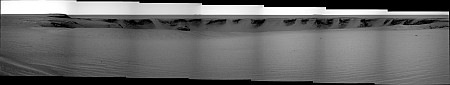
jvandriel
Sep 28 2006, 05:09 PM
Here is the Navcam panorama of Victoria.
Taken with the L0 Navcam.
jvandriel
Nix
Sep 28 2006, 05:10 PM
QUOTE (Stu @ Sep 28 2006, 05:45 PM)
Couldn't resist it... lens flare and all!
Click to view attachmentVery nice Stu!
Nico
fredk
Sep 28 2006, 05:20 PM
QUOTE (karl @ Sep 28 2006, 04:52 PM)
It is interesting how the dune bridges a gully extending up from the bay.
Karl, I think that "gully" is actually a crater just outside of the rim. The official jpl release called it "Duck Crater".
Nix
Sep 28 2006, 05:35 PM
Cabo Verde...

Nico
fredk
Sep 28 2006, 05:40 PM
Just to clarify things a bit amidst this mad flurry of images, the pancams we had down today are actually from the sol 951 location. Some were taken sol 951, some sol 952 before the bump up towards the rim.
jabe
Sep 28 2006, 05:43 PM
QUOTE (Nix @ Sep 28 2006, 05:35 PM)
An y guesses on how tall the "bluff" is? can't quite get a sense of scale..just like when oppy first landed and first pics came down..thought it was a huge wall it was in front of...
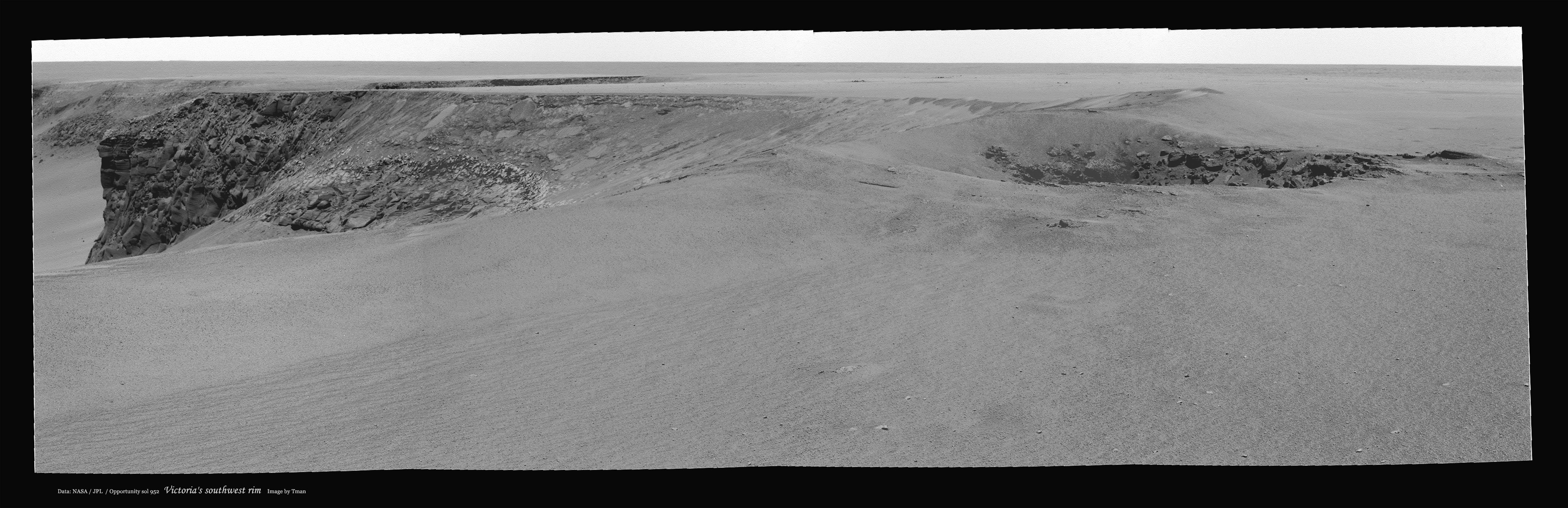
Tman
Sep 28 2006, 05:48 PM
These new stunning pictures from Mars are so stimulating...
After dedusting of PTGui I tried to bring additionally a bit more light on the cliff (indeed Michael brought it already).

aldo12xu
Sep 28 2006, 05:51 PM
QUOTE (Indian3000 @ Sep 28 2006, 04:11 PM)
vertical projection 1cm/pix
Click to view attachmentMan oh man, I was just going gaga over the latest images on the old thread and then I discover this! I thought I was going to fall off my seat looking down at the floor of the crater
To me, this is the first image that instantaneously gives a sense of how big/deep Victoria is.
Thanks Indian3000!!..............any chance of getting the corresponding right image as well for an all out stereo plunge into the crater??
fredk
Sep 28 2006, 06:16 PM
Lot's of requests for scale info - here's my measurement of the size of the Verde cliff:
Click to view attachmentAnd here's the height of Frio cliff:
Click to view attachmentThese values are roughly consistent with the heights of cliffs on the far rim we can see.
Edit: these are based on distances of 59 metres to Verde and 120 metres to Frio cliffs.
volcanopele
Sep 28 2006, 06:23 PM
That Capo Verde outcrop looks like it would be reasonable to reach. The slope in the Duck Bay next to the outcrop looks reasonable at first glance, making that outcrop what I would think would be a good first glance target. Some of the rocks lower down in the sequence in that outcrop look layered, though I am a bit concerned that the impacting processing may have altered the original arrangment of the rocks in that area, making it difficult to assess which rocks came first in the sequence.
Nix
Sep 28 2006, 06:24 PM
Thanks for those measurements fredk, I already had the impression I was underestimating the size

Left/Right views for use with SPM or whatever stereoviewers you have out there..
Cabo Frio - left eye

Cabo Frio - right eye

Cabo Verde - left eye

Cabo Verde - right eye

Nico
mhoward
Sep 28 2006, 06:29 PM
QUOTE (fredk @ Sep 28 2006, 06:16 PM)
Lot's of requests for scale info - here's my measurement of the size of the Verde cliff:
I think, in imperial units, 15.3 meters works out to "Holy cow! Over 50 feet!"
Tman
Sep 28 2006, 06:31 PM
I'm a bit out of form. Dose ~15 m mean that we could be already deeper in the layering than it was possible inside Endurance?
fredk
Sep 28 2006, 06:41 PM
Tman - I read recently that Endurance gave us about 7 metres. Perhaps someone could confirm this?
Nico -
Nico! Thanks so much for L and R pans - I love to view with Stereophotomaker.
Nix
Sep 28 2006, 06:48 PM
Yes, SPM is great! Do you Auto-align the images, it seems to be doing a good job on that (latest version I think it is..)
Nico
Holder of the Two Leashes
Sep 28 2006, 06:58 PM
QUOTE (Nix @ Sep 28 2006, 12:35 PM)
Cabo Verde...
Nico
(Deep bass voice here)
Ooooohhhhhhhhhhhhh Yeeeaaaaaahhhh !!
algorimancer
Sep 28 2006, 07:17 PM
QUOTE (Nix @ Sep 28 2006, 01:24 PM)
Thanks for those measurements fredk, I already had the impression I was underestimating the size
...
I love the fine layering above Cabo Frio. All sorts of interesting structure over there. Neat.
ngunn
Sep 28 2006, 07:19 PM
A question: Are we sure that the current view shows us the whole slope continuously down to the dunefield? Could there perhaps be a mini-horizon effect at the entrance of Duck Bay (about the distance of the foot of the Cape Verde cliff) and beyond that a somewhat steeper slope down?
Reckless
Sep 28 2006, 07:19 PM
The rocks may be jumbled but there are layers everywhere
Roy F
Indian3000
Sep 28 2006, 07:23 PM
QUOTE (aldo12xu @ Sep 28 2006, 07:51 PM)
Man oh man, I was just going gaga over the latest images on the old thread and then I discover this! I thought I was going to fall off my seat looking down at the floor of the crater
To me, this is the first image that instantaneously gives a sense of how big/deep Victoria is.
Thanks Indian3000!!..............any chance of getting the corresponding right image as well for an all out stereo plunge into the crater??
is it this you want ?
Click to view attachment
odave
Sep 28 2006, 07:49 PM
QUOTE (fredk @ Sep 28 2006, 02:16 PM)
Lot's of requests for scale info - here's my measurement...
Thanks Fred.
This press release gives the height of Burns Cliff back at Endurance as 10m - which falls right between your measurements of Cabo Verde and Cabo Frio.
climber
Sep 28 2006, 07:51 PM
QUOTE (Pavel @ Sep 28 2006, 06:55 PM)
Thanks!
Did you notice the faces? That would make excellent avatars!
Oh yes! And for the one that don't get a feeling of the size of the cliffs : here is one foot
Click to view attachment
odave
Sep 28 2006, 07:56 PM
QUOTE (Tman @ Sep 28 2006, 02:31 PM)
I'm a bit out of form. Dose ~15 m mean that we could be already deeper in the layering than it was possible inside Endurance?
The UMSF rockhounds can correct me if I'm wrong, but I believe we've moved down-section from Endurance as well, so we may be able to see even deeper
climber
Sep 28 2006, 08:00 PM
QUOTE (Indian3000 @ Sep 28 2006, 09:23 PM)
I realy LOVE this. Never thought we could have this kind of feeling. Thanks Indian3000
BrianL
Sep 28 2006, 08:05 PM
Wow and double-clink! What a great birthday present today's pics are.
Can we get some mystery men down there?
Brian
Stu
Sep 28 2006, 08:07 PM
Is this kind of right...ish..?
Click to view attachment
Tman
Sep 28 2006, 08:08 PM
If Oppy's twin should like just to park on Frio Cliff, it may look like:
(Oops...O'lala...
)
http://www.greuti.ch/oppy/oppy_sol952_olala.jpgedit:
Stuart, looks like we got about the same size on the cliff. (Is he an average European?

)
Happy Birthday Brian!
climber
Sep 28 2006, 08:18 PM
QUOTE (BrianL @ Sep 28 2006, 10:05 PM)
What a great birthday present today's pics are.
Brian
BTW, tomorrow will be Spirit 1000th day on Mars (Earth days, not Sols)
This is a "lo-fi" version of our main content. To view the full version with more information, formatting and images, please
click here.