Help - Search - Members - Calendar
Full Version: Duck Bay
Unmanned Spaceflight.com > Mars & Missions > Past and Future > MER > Opportunity
Pages: 1, 2, 3, 4, 5, 6, 7, 8, 9
Stu
QUOTE (Tman @ Sep 28 2006, 08:08 PM) *
If Oppy's twin should like just to park on Frio Cliff, it may look like:


... it's going to do a "Thelma and Louise" and hurl itself off the top of the cliff!!!!!! ohmy.gif ohmy.gif ohmy.gif Don't DO it Oppy!! It's not worth it!! You've a lot more of Mars to see yet!!! It doesn't have to end here!!!!

wink.gif
Nix
Happy Birthday BrianL smile.gif

I LOooove these layers, they're everywhere. I feel like a little child in a new sandbox tongue.gif


Nico
climber
Hey Climber,
Would you like to have a go at this? Any good climbing routes?
http://qt.exploratorium.edu/mars/opportuni...EVP0657R0M1.JPG
Castor


You only can tell when you're at the foot of the cliff. Pancam will tell more but it looks possible. Would love to have a go. BTW I dream of been on Mars those nights (very cool); will tell you tomorrow how it is wink.gif
Nirgal
QUOTE (climber @ Sep 28 2006, 09:51 PM) *
Oh yes! And for the one that don't get a feeling of the size of the cliffs : here is one foot biggrin.gif
Click to view attachment


Wow Stu,

blink.gif 
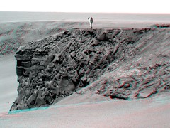
this is the best Victoria cliff colorization yet ...

Very good overall color mood of the image !
Indian3000
view of Opportunity's postion sol 952 from sol 943, with my auto-path software ...
( I dont have yet calibre the orientation of rover model )


Click to view attachment

and a view in perspective of 3D construction behind auto-path
( I am not yet completely sure of the position of the ground texture )

Click to view attachment
jamescanvin
14 pointing colour pancam mosaic of Duck Bay up for tosol! And does the "1" mean that there is more to come? Could this be an 'arrival' pan afterall?

CODE
953 p2390.08 84  0   0   84  4   172  pancam_duck_bay_1_L256R267


Great work everyone shame I missed the party. Hopefully we'll get some colour later. smile.gif

James
alan
JPL's image release
http://marsrovers.jpl.nasa.gov/gallery/pre.../20060928a.html
fredk
QUOTE (ngunn @ Sep 28 2006, 07:19 PM) *
A question: Are we sure that the current view shows us the whole slope continuously down to the dunefield? Could there perhaps be a mini-horizon effect at the entrance of Duck Bay (about the distance of the foot of the Cape Verde cliff) and beyond that a somewhat steeper slope down?

Yeah, if you check out today's navcams it's pretty clear we can see continuously down Duck Bay right to the dunes along the north side of Duck Bay, the side below Cape Verde, and similarly on the south side below Frio. But in between, more or less directly below us, our view is blocked by the upper part of the bay.
djellison
14 frames... 7 x 2 perhaps... I would call that part 1 of the arrival pan, thus making 952 the arrival sol.

Doug
jamescanvin
Good call Doug.

Horay we've arrived! smile.gif ...21 sols off, dammit!

I agree, it must be 7x2, 14x1 (>180) would overlap with a lot of the cape images from 952
Nix
Yippieee!! 14 color frames smile.gif

'extreme3D' , co-registered on Cabo Verde for more detail;


Nico
DDAVIS
With todays images, another one occurs to me: We have to be careful about what time of day we image cliff faces - large areas of Capes Frio and Verde are in deep shadow in these images!

Shadows are not necessarily something to be avoided...images with the crater partially filled with shadow could be very dramatic, indeed landscape photographers tend to avoid noon lighting to give 'modeling' to the scenery. A time lapse sequence of the lighting changing would indeed be very nice to provide both topographic and albedo information across the view.

Don
hortonheardawho
Astro0
I know the true-colour images are on their way, but here's a quick colourised version of yestersol's pan.
Click to view attachmentFile:563k
Astro0

PS: A quick nod to Stu for his versions and the use of lens flare (I like it too!) wink.gif
tedstryk
QUOTE (jamescanvin @ Sep 28 2006, 09:35 PM) *
84 4 172 pancam_duck_bay_1_L256R267


Great work everyone shame I missed the party. Hopefully we'll get some colour later. smile.gif

James


Glad to see they are taking this so quickly...I would hate for something to happen over conjunction, after coming this far, and never getting a color view.
RedSky
QUOTE (hortonheardawho @ Sep 28 2006, 07:10 PM) *


Horton, that's a great image. It reminds me of this pic that NASA has used at times on NASA-TV and at places on its web site. I always thought "Yeah, right. Like they'll really have a suited Mars astronaut repelling down a cliff." But now that I see these bluffs...

Click to view attachment
Holder of the Two Leashes
QUOTE (Nix @ Sep 28 2006, 05:54 PM) *
Yippieee!! 14 color frames smile.gif

'extreme3D' , co-registered on Cabo Verde for more detail;


Nico


Very impressive! Good job Nico.

Would anyone here care to hazard a guess, based on slope only and assuming solid packing of the soil, whether they think Oppy can make it down there to examine the layers on that rock? And then what about the probability of making it back UP again? My amateurish guess, after the 3D view, is probably "yes" to both. I'd be interested in a more informed opinion.
Floyd
Mission Update from Steve Squyres
http://athena.cornell.edu/news/mubss/

Next stop Cape Verde where Opportunity will spend superior conjunction.
MarkL
QUOTE (hortonheardawho @ Sep 28 2006, 11:10 PM) *

Oh my. That is such an evocative image Horton. For me that (and the raws you built it from) tops them all. The only thing that caused my jaw to drop as much was the first images of Eagle on landing day. OK maybe some of the summit shots, but those more for the sheer awe of being up on top of the hill. I just shake my head every so often in disbelief that they managed to get here. Its a hell of a treat for armchair spacemen.
MarkL
QUOTE (Holder of the Two Leashes @ Sep 29 2006, 01:00 AM) *
Would anyone here care to hazard a guess, based on slope only and assuming solid packing of the soil, whether they think Oppy can make it down there to examine the layers on that rock? And then what about the probability of making it back UP again? My amateurish guess, after the 3D view, is probably "yes" to both. I'd be interested in a more informed opinion.

I calculate the slope to be about 20 degrees dependent on how close to vertically aligned the image is (looks very close to me). So I'm sure you're right on both counts. I might add that this may well be the only location where a successful ascent could occur. And they're driving right past it! I still think one Victoria lap is called for before going in too far but this may count as a safe toe dip.
Holder of the Two Leashes
QUOTE (MarkL @ Sep 28 2006, 09:27 PM) *
I calculate the slope to be about 20 degrees dependent on how close to vertically aligned the image is (looks very close to me). So I'm sure you're right on both counts. I might add that this may well be the only location where a successful ascent could occur. And they're driving right past it! I still think one Victoria lap is called for before going in too far but this may count as a safe toe dip.


Thanks. I don't mind them taking their time and eventually coming back here. It's nice to know that there is at least one reasonable slope (again if the soil is not too loose and deep) to come back to, and maybe better ones down the road. Personally, I'm awfully curious to get a close up look at whatever the "beacon" is before they try anything risky. And I know it's going to be awhile before they do try anything risky.
fredk
Well, now that we've "officially" arrived, the mystery men have come out of hiding. They were a little shy at first, hiding amongst the cliffs, but have emerged to welcome us to Vicky with their amicable waves.

Notice the men down in the dunes and those scattered along the far rim - navcam can barely resolve them at those distances.

The pan is from Michael Howard's superb sol 952 navcam pan.

Horton, I think your man on Frio matches my man's height almost exactly!
Click to view attachment
ElkGroveDan
QUOTE (fredk @ Sep 28 2006, 08:18 PM) *
Well, now that we've "officially" arrived, the mystery men have come out of hiding.


Thank you. Been wondering where they were.
CosmicRocker
...a few carry-over comments from the locked thread, and some for the new one. Having just returned home from a business trip where I wasn't able to really keep up with everything, and then finding the latest pancams, I'm overwhelmed, as I suspect everyone is. The geology in this playground is abundant enough to keep many numbers of us kids happy for quite a long time. I am somehow reminded of the title of an album and song by a British rock group from my youth that may still exist in some reincarnated form. Does anyone recall "In the eyes of a child" by the Moody Blues?

QUOTE (akuo @ Sep 28 2006, 09:27 AM) *
Amazing views.

With these, there is also some sadness. I can't imagine Opportunity ever leaving Victoria. So this is also her resting place.

Still, there is so much to discover. The capes and bays almost makes Victoria like a series of craters, there is always something new behind the wall of the nearest cape!
Akuo: You may be correct. There is so much to discover here that Opportunity may never leave, but as you say, there is so much to discover. It won't be sad if she never leaves this place. This is the playground she was deigned to explore, and it it not impossible to imagine that she will eventually move on toward yet another horizon. But, the machine will eventually wear out. We should keep looking up. Let's keep our fingers crossed for the time being.

QUOTE (dot.dk @ Sep 28 2006, 09:42 AM) *
Words fails me so I'll just post a link... ohmy.gif

http://nasa.exploratorium.edu/mars/opportu...EKP2389R1M1.JPG

Dot.dk: I would agree with you that that image is probably the best one yet returned by a rover, especially in 3D. smile.gif I can't stop looking at it.

Oh, and I almost forgot to thank hortonheardawho for his inspiring image. That was quite nice.
mhoward
QUOTE (fredk @ Sep 29 2006, 04:18 AM) *
Notice the men down in the dunes and those scattered along the far rim - navcam can barely resolve them at those distances.


Wow, now that is amazing, especially the figures on the drifts. I could hardly believe it, so I had to verify it. By my math, a 1.8m (6ft) individual on the far rim (800m away) would have an angular size of 0.13 degrees, or about 3 Navcam pixels. The figures on the drifts are around half that distance away, so it makes sense they would be pretty small too. Looks like you are spot-on. blink.gif

A figure on the far rim would be an enormous 8 pixels high as seen by Pancam.
Shaka
QUOTE (fredk @ Sep 28 2006, 06:18 PM) *
Well, now that we've "officially" arrived, the mystery men have come out of hiding.

biggrin.gif You da MEN, Freddo! You da men. I always hoped they were there.

Many of us are close to those "men from Mars". They were milestones in many a life-time's daydreams - wakened in a well-worn book, or, more-likely, in a Saturday peanut-littered movie theater way back when - when The Martian was Hollywood's alien poster child.
Who needed a Boogeyman or a Tinkerbell? Here was Terror and Awe, but as well comforting pangs of Respect and Sympathy! We took to heart Klaatu's stern, Oxbridgian ultimatum, while secretly longing for our very own E.T. to follow us home.

Then we grew up, damn-it-all.

Mars. mars.gif Certain things you don't outgrow. Certain things grow too close to the source.
Our Mars far supercedes the fourth planet from the sun. For many of us it looms huge, in the cosmos of our imagination, as a next-best-thing to Heaven. To earthlings it stands well aloof from anything we know, but somehow we know that there a kind of welcome awaits us, deserving or not.

Spirit and Opportunity have given us precious spoonfuls of a daydream world.
Shhh...Don't tell NASA. They might claim royalties.
cool.gif
Aberdeenastro
QUOTE (Nix @ Sep 28 2006, 09:23 PM) *
I LOooove these layers, they're everywhere. I feel like a little child in a new sandbox tongue.gif


Nico


Nico,

I'm not sure I agree with your layer interpretation, but put 10 geologists in the same sandbox and they'll come up with 10 different interpretations! biggrin.gif

I think the layers follow the crater contours rather than bend up towards the edge. I think we can see some of the same layers that we saw at Endurance (I'm afraid I've forgotten the formation names), but it's difficult to make a confident correlation. I think the top is the evaporite, followed by the same aeolian layers that saw at Endurance. There then seems to be a bright conglomeratic layer, which may be the bright layer we can see on the far rim of VC. Below that are layers we haven't seen before, but because they are in shadow it's hard to interpret them from our current location.

I'd be interested in the views and comments of my fellow forum geologists.

Click to view attachment

Thanks for the base image Nico.

Castor
climber
QUOTE (Castor @ Sep 29 2006, 10:36 AM) *
There then seems to be a bright conglomeratic layer, which may be the bright layer we can see on the far rim of VC. I'd be interested in the views and comments of my fellow forum geologists.
Click to view attachment
Thanks for the base image Nico.
Castor

I'm NOT a geologist, OK?
I've seen this whitish layer and also thought it could relate to the white line visible on the far rim BUT I rejected this because the near rim is much higher than the far rim as compared to the plain so the layer here is actualy WAY higher than on the other side. I was expecting it been some say, 10 meters further down.
On another hand, in some bays, we can see at least two of these white layers, so, may be they are more...
Julius
I dont see any problem for Oppy to enter Victoria;the slopes in the alcoves seem to be gentle enough. biggrin.gif
nprev
Hopefully not OT, but CNN has just picked up on Oppy's arrival at Victoria...with any luck, we'll see some renewed major media coverage soon! smile.gif
Nirgal
QUOTE (fredk @ Sep 29 2006, 06:18 AM) *
Well, now that we've "officially" arrived, the mystery men have come out of hiding. They were a little shy at first, hiding amongst the cliffs, but have emerged to welcome us to Vicky with their amicable waves.

Notice the men down in the dunes and those scattered along the far rim - navcam can barely resolve them at those distances.

The pan is from Michael Howard's superb sol 952 navcam pan.

Horton, I think your man on Frio matches my man's height almost exactly!
Click to view attachment


PHANTASTIC, fredk !!!

I must admit that I'm one of the unfortunate ones whoe doesn't seem to get a grip on viewing the 3D
images (the x-eye anaglyphs only cause eye strain and headaches for me and ed-green glasses also didn't do the trick for me sad.gif

But, Wow: your Mystery men (esecially if distributed over the whole image) are more than a substitute for the missing 3D effect !

I can say that among all the many images, be it navcam,pnacam,b/w, color or 3D, it is your mystery-men-pan that gave me, for the first time, the first *real* impression of scale and sense of "being there" on mars
looking at a real landscape ...

Phantastic, Unbelievable !

smile.gif


P.S.: when I first saw the mystery men I thought that it would be even better to use men in space suits for more realism... but now I'm convinced that it's actually better to use the more abstract form of just the shilouette of the waving man thereby not even trying to pretend "false realism" but just using the men as some abstract points (i.e. "semantically outside" the real image content) just as a optical point of orientation for the human vision,

just simple and brilliant !
Tman
QUOTE (mhoward @ Sep 29 2006, 07:35 AM) *
Wow, now that is amazing, especially the figures on the drifts.

Yea, so far I was oblivious of those dune size on the ground of Victoria - they are big! Maybe that big that Oppy wouldn't be able to look over them if he stand between.
MahFL
Bah, these cameras fool me all the time, I thought the cliffs were higher.
MahFL
Oppy is female smile.gif.
Tman
QUOTE (Castor @ Sep 29 2006, 10:36 AM) *
I think the layers follow the crater contours rather than bend up towards the edge. I think we can see some of the same layers that we saw at Endurance (I'm afraid I've forgotten the formation names), but it's difficult to make a confident correlation.
I'd be interested in the views and comments of my fellow forum geologists.

Click to view attachment

Thanks for the base image Nico.

Castor

I'm not a geologist too. Even so, it seems plausible to me that layers run more horizontally.

Apropos, what does the look of Victoria's rim say about the processes during the explosive build of the crater? Could it be right those "ramps" between the cliffs were more exposed to the forces than the spots where we can see cliffs now... if so the ramps were right "smoothed" by matter that were exploded out, whereas the cliffs show more original size of the layers - "only" "lifted out" from a point between now and the middle of the crater...?
Tman
QUOTE (MahFL @ Sep 29 2006, 12:38 PM) *
Oppy is female smile.gif.

Oops, of course! biggrin.gif How could I that forget...
climber
I look forward for a view from Cape Verde where we'll see Oppy's track on Duck Bay. This also will give us a sense of size and distance wheel.gif
Aberdeenastro
From Steve Squyres latest update:

"After that has been shot, we're heading for our next location... Cape Verde. We were considering both Cape Verde and Cabo Frio, and when we looked at all the factors together, Cape Verde won out. Wherever we stop next is where the rover will spend "superior conjunction" -- the upcoming period when Mars will be out of sight behind the sun, making communications impossible for a short while. Conjunction is coming soon, so we want to get to our conjunction spot quickly, and Cape Verde looked like an easier drive than Cabo Frio. Another factor is that we want to be parked on rock over conjunction, so that we can do some work on rock with the IDD. There seems to be good exposure of rock at Cape Verde, but little or none of it at Cabo Frio. So Cape Verde it is."

I was a little surprised by the decision to go to Cape Verde first. To me Cabo Frio looked like an easier drive, but then what do I know about rover driving! biggrin.gif

I can understand the desire to get straight into some rock work, but, as a geologist, I would have thought it was better to stand back and take in the pancam views before deciding on the rock campaign. Maybe there isn't time for that. To me Cabo Frio offers the better viewpoint of the whole crater. You can't see much of the northern and north-western cliffs from Cape Verde.

Who knows, maybe we'll visit both capes. Either way, I'm just so delighted to be able to witness this in near real-time. Thanks to JPL, SS, UMSF and all the people that contribute here.

Castor
MahFL
Some navcams and rear haz cams came down, not sure what all that is about.
Aberdeenastro
I think they're just more images from sol 952 (site no. 76EV). You can see the sol 951 location a few metres back.

Castor
jamescanvin
The rear hazcam is from yestersol and the 3 navcams are from tosol but just to complete the 360 from this location.

No driving tosol, it's pancams we're waiting for tosol! smile.gif
Ant103
Yes, and it's so long to waiting for Pancams pics... and so exciting biggrin.gif

So, my version of a portion of the Pancam pano from Sol 951 & 952 frames (manually stitch because Autostitch curve the horizon...).

Gray
QUOTE (Castor @ Sep 29 2006, 08:36 AM) *
I think the top is the evaporite, followed by the same aeolian layers that saw at Endurance. There then seems to be a bright conglomeratic layer, which may be the bright layer we can see on the far rim of VC.
I'd be interested in the views and comments of my fellow forum geologists.

Click to view attachment


Castor,
I pretty much agree withthe boundaries that you've drawn. I'm intrigued by the layer you have labeled "Endurance Aeolian Unit". That layer is at the surface for a good bit of the cape. At the surface, it looks to me to have the appearance of the rocks that were calling "pavers" when we were at Endurance. Now we can see the near vertically eroded edge of these and it looks to me to be a large brecciated unit. The "pavers" are actually large angular boulders that have been planed off by surficial erosion and weathering.
If this is the case then it says something more about the timing of the erosion fo the crater walls. It has occurred since those large blocks were planed flat at the surface.

What do you think?
Bill Harris
RE: Nix, Castor and Climber's comments--

I can't speak for every geo-type, but I'm not sure where we are in the stratigraphic section. One of the things we use to locate points in the section are marker beds. On Earth, we use chemical markers (such as the K-T iridium layer) or rock types (such as Cretaceous sands and Pottsville sandstones) or fossil markers. We haven't found (AFAIK) a good marker bed here. We did find some chemical differences in the evaporites at Endurance and we might find similar chemistries here, but we haven't seen a series of similar exposures along the traverse to tie things together. We have noted the Halfpipe Formation but we don't know if this is a distinct stratgraphic horizon of cobbles or discontinuous accumulations of cobbles. And we don't have accurate elevations on the traverse.

The kids in the back room or the Suits in Ithaca may know more, but from what I've seen we haven't found that holy grail. What we can do is make some shrewd guesses and let them stand until disproved...

--Bill
Gray
QUOTE (Bill Harris @ Sep 29 2006, 01:37 PM) *
RE: Nix, Castor and Climber's comments--

... We haven't found (AFAIK) a good marker bed here. ...
--Bill


I agree with Bill. I think any stratigraphic correlations with Endurance would be premature at this point. The layer with the large boulders which were weathered to 'pavers' is not necessarily correlative with the one at Endurance. I'm envisioning it as a layer of impact debris that would surround any crater.
Jeff7
QUOTE (nprev @ Sep 29 2006, 05:57 AM) *
Hopefully not OT, but CNN has just picked up on Oppy's arrival at Victoria...with any luck, we'll see some renewed major media coverage soon! smile.gif


I hope they have a little snippet that goes something like, "Yes, this is in fact the same Opportunity rover you heard about 2 years ago."
wink.gif


Fredk - thank you for your Mystery Man mosaic. It really does help show just how big this crater is.
MahFL
Some pancams came down, the boring ones on the left hand side.......lol.
ngunn
QUOTE (fredk @ Sep 28 2006, 10:49 PM) *
Yeah, if you check out today's navcams it's pretty clear we can see continuously down Duck Bay right to the dunes along the north side of Duck Bay, the side below Cape Verde, and similarly on the south side below Frio. But in between, more or less directly below us, our view is blocked by the upper part of the bay.


I thought so. We need a legless Mystery Man!
Aberdeenastro
QUOTE (Gray @ Sep 29 2006, 02:47 PM) *
I agree with Bill. I think any stratigraphic correlations with Endurance would be premature at this point. The layer with the large boulders which were weathered to 'pavers' is not necessarily correlative with the one at Endurance. I'm envisioning it as a layer of impact debris that would surround any crater.


I also agree that any correlations are premature at this stage. I'm just speculating. I wonder if we left the evaporite behind at the Victoria annulus edge and we are seeing the Endurance aeolian unit at the surface here? I guess our trip to Cape Verde will help here.

Castor
mhoward
A bit more of the 76EV Navcam pan came down from sol 953.

This is a "lo-fi" version of our main content. To view the full version with more information, formatting and images, please click here.
Invision Power Board © 2001-2024 Invision Power Services, Inc.