Processed enlargement of
HAMO 33:

Imaging location map:

Got a tip on this one from Landru79. Thanks again!
Bill Harris
Oct 8 2015, 06:53 PM
Today's offering, HO-33, is just a little crumb stuck up way north with nothing noteworthy (except for a slumpage half in the shadows). Couldn't even find related SO- or HO- images for it. But again Team, thanks for sharing!
A color-coded index map:

--Bill
Here's a rough colorization of HAMO 33 from today:

As I understand it, IR and red have been combined and added to the blue channel and then the green is some sort of albedo map according to the color map description
here. I've been working on synthesizing a proper green channel from a known blue and red channel for a few months trying to get it as close to correct as possible and this process was used in the image above. Dark pinks are still rendered too orange in the process but it seems mostly reliable in broad use.
nprev
Oct 8 2015, 11:40 PM
Haven't seen this mentioned: There's gonna be a
live stream tonight (9 Oct/0200 GMT, 8 Oct/1900 PDT) titled "Unveiling Ceres".
EDIT: Starting now.
Gladstoner
Oct 9 2015, 06:28 PM
Bill Harris
Oct 9 2015, 06:53 PM
The cat-scratches and *poof* from that prominent crateroid are curious.
--Bill
Processed enlargement of
HAMO 34:

Imaging location map:

The terrain folding is pretty interesting. Definitely was interested in seeing this in HAMO. Looks like something flowed across the ground and buckled as it began to stall.
alan
Oct 10 2015, 09:21 PM
QUOTE (nprev @ Oct 8 2015, 06:40 PM)

Haven't seen this mentioned: There's gonna be a
live stream tonight (9 Oct/0200 GMT, 8 Oct/1900 PDT) titled "Unveiling Ceres".
EDIT: Starting now.
Thanks for pointing that out, I had missed NASA's announcement of the discovery of water on
Mars Vesta. (around one hour in)
Bill Harris
Oct 11 2015, 01:03 AM
Summary, please, for those who don't do livestream?
--Bill
djellison
Oct 11 2015, 01:13 AM
FOV
Oct 11 2015, 01:14 AM
"Unveiling Ceres" is also a YouTube:
https://youtu.be/_G9LudkLWOY
JohnVV
Oct 11 2015, 07:31 AM
HAMO-34
-- rough remap to orthographic projection to remove camera tilt
-- North UP


Bill Harris
Oct 13 2015, 03:07 AM
This series of images may trend northward between craters Urvara and Yalode and into the fractured continental terrain south of Occator. The montage will be updated as new images come in. Currently the five images in the montage are HAMO-19, -20, -21, -22 and -34.
https://univ.smugmug.com/Dawn-Mission/Ceres...--enh--pano.png--Bill
Landru79
Oct 13 2015, 02:30 PM
Newbie composition/location. I hope no disturb

Hamo 35 ¿close shot on "Zadeni"?
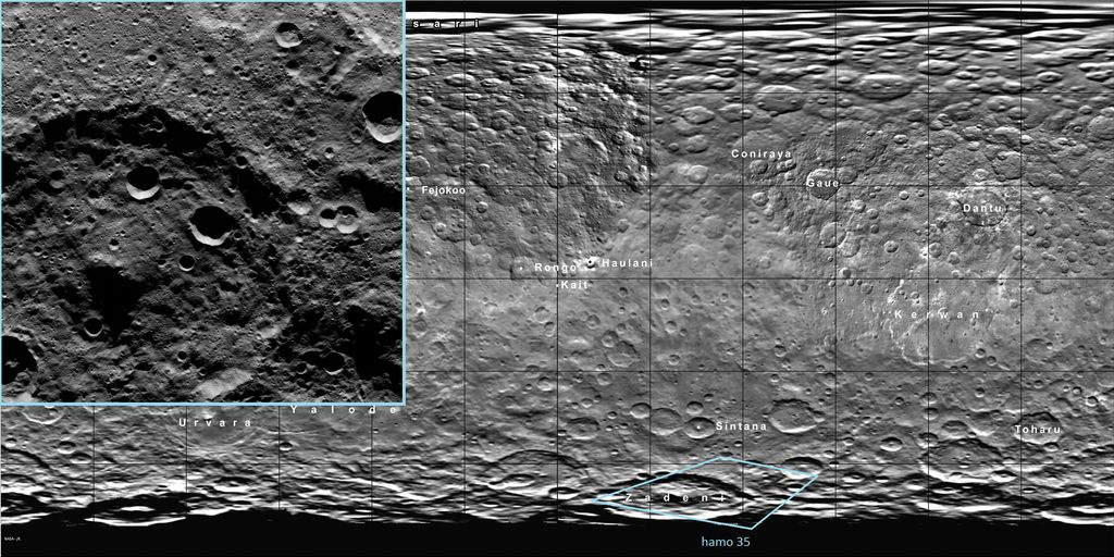
Bill Harris
Oct 14 2015, 04:38 AM
HO-36 is situated midway between HO-4 and HO-5. Has a nice flowage in the SE corner.
Presented simply as a
purty picher:
Area of flowages and slumpages near crater OxoPeculiar mass-wasting processes near crater Oxo, which is in an area suspected of seismic and tectonic activity.
https://univ.smugmug.com/Dawn-Mission/Ceres...--enh--pano.png--Bill
Daniele_bianchino_Italy
Oct 14 2015, 09:11 AM
Good morning,
someone made a realistic color image of as Ceres appears to the human eye?..Many ThanKS
Bill Harris
Oct 14 2015, 04:37 PM
Today's HAMO-37 is Oxo crater with a different lighting angle ( HO-5, HO-29, HO-37 series ).
--Bill
ZLD
Oct 18 2015, 02:40 AM
Overdue update here.
-----------------------------------
Processed enlargements
-----------------------------------
HAMO 35 HAMO 36
 HAMO 37
 HAMO 38
 HAMO 39
-------------------------
Imaging location map
-------------------------

Edit: Just realized that when I enabled all the layers, I overlapped some labels. I'll correct this tomorrow.
Gladstoner
Oct 18 2015, 06:29 AM
QUOTE (ZLD @ Oct 17 2015, 09:40 PM)
-------------------------
Imaging location map
-------------------------
[url=[/url]
Edit: Just realized that when I enabled all the layers, I overlapped some labels. I'll correct this tomorrow.
Thanks much for the effort. It is nice to have an updated index map for the raws.
Daniele_bianchino_Italy
Oct 18 2015, 10:40 AM
Grazie ZLD : )
Bill Harris
Oct 18 2015, 02:13 PM
A Crateroid surrounded by Jumbled and Chaotic terrainThis initial image is a 2x-enlarged enhanced image of the northern portion of HAMO-39 and is shown without the usual descriptive annotations. It is an oblique image and has been rotated and cropped to give a better perspective view.
https://univ.smugmug.com/Dawn-Mission/Ceres...res2x--enh3.pngThis spot has to be "Where's Waldo" of Cerean locales. The more you look, the more you see.
--Bill
Bill Harris
Oct 20 2015, 02:03 PM
The current HAMO public image, HO-40, is noteworthy for... nothing. After the formation of the unnamed 100Km crater in the center and subsequent impact cratering this area has lain virtually undisturbed for aeons-- no hydrothermal activity, no tectonic activity and, with the exception of the mass-wasting event from the creation of a 25Km crater on the NW rim, no major slumpages.
This spot is a prime example of an undisturbed area and contrasts very well with the other images in the series across crater Toharu. Good work, Dawn Team.
https://univ.smugmug.com/Dawn-Mission/Ceres...orient--enh.png--Bill
ZLD
Oct 21 2015, 02:51 PM
-----------------------------------
Processed Enlargements
-----------------------------------
HAMO 40 HAMO 41
-----------------------------------
Imaging location map
-----------------------------------

ZLD
Oct 21 2015, 05:19 PM
----------------------------------------
Processed Enlargement
----------------------------------------
HAMO 42
----------------------------------------
Imaging location map
----------------------------------------

JohnVV
Oct 21 2015, 07:05 PM
Ceres dose seam to have a over abundance of the hexagon shaped craters .
ZLD
Oct 22 2015, 05:46 PM
----------------------------------------
Processed Enlargement
----------------------------------------
HAMO 43
----------------------------------------
Imaging location map
----------------------------------------

Bill Harris
Oct 23 2015, 09:55 AM
QUOTE (JohnVV @ Oct 21 2015, 02:05 PM)
Ceres dose seam to have a over abundance of the hexagon shaped craters .
Polygonal craters are a very important structural clue.
QUOTE (Bill Harris @ Oct 6 2015, 05:53 AM)
I'm having a look at the many polygonal craters we see on Ceres. What sort of analytic techniques are used nowadays? The usual technique I'm used to is "rose" or "rosette" diagrams for looking at the orientations of the walls (facets). Along with other linear features, such as lineations, floor-fill fractures and the odd linear central peak we see.
What is a good current (and maybe free) plotting software for the rose diagrams? Years ago we used ISM, "Interactive Surface Modeling", an ESRI product, but it was a big server-hosted program.
And do we know of current "polygonal crater" references? The recent work appears to be solely by "T Öhman, et al", and of course the classic work is by Baldwin, et al.
--Bill
I've ended up using a old database template I used to use for joint and fault orientation. Doesn't do much, but it keeps the data in neat rows and columns and outputs rose diagrams.
--Bill
Floyd
Oct 23 2015, 04:33 PM
I know they are releasing 1 image a day--thus the map coverage is filling up very slowly. Anyone know about how many images they actually take per day? By the end of HAMO aren't they supposed to have about 5-10 images deep coverage of every spot on the globe? So does that mean that they are taking 10 - 30 images /day?
Holder of the Two Leashes
Oct 23 2015, 05:09 PM
Pictures per day is probably a variable, since they are in a nineteen hour orbit. Besides, they store up everything for days and then transmit it all between mapping cycles, so for a couple of days in a row they don't take any pictures.
In any case, they have recently promised on the mission status page that the upcoming issue of the DAWN Journal will have a detailed recap of HAMO, so you will probably get some good answers in a few days.
The only missed pictures were a few from the third mapping cycle. Except for those, I expect every piece of visible real estate got scrutinized at least six times, with some overlap.
HAMO is about to be over. All the picture taking is done and everything transmitted to earth.
In a little over five hours from now, ion engine two will fire up and DAWN will begin its decent to LAMO.
Bill Harris
Oct 24 2015, 11:55 AM
Crater Victa--subject of HAMO-44-- now we can see why this 28 Km crater received it's own name.
https://univ.smugmug.com/Dawn-Mission/Ceres...enh2--victa.pngAnd a montage of today's HO-45 image and an earlier image showing part of the Samhain Catena, a major tectonic feature south of Occator.
https://univ.smugmug.com/Dawn-Mission/Ceres...orient--enh.png--Bill
fredk
Oct 26 2015, 09:52 PM
The new Occator mosaic looks cleaner than the previous release:
Click to view attachmentHowever, it's still a merge of long- and short-exposure images, so interpret with caution...
Edit: Oops, sorry for posting to the wrong thread.
ngunn
Oct 26 2015, 10:34 PM
And it's still bleached out in the bright areas. We really need to see these locations with a much shorter exposure even if it means the surrounding dirt appears completely black. We're half way to the outer solar system but still snow blind.
Bill Harris
Oct 27 2015, 01:32 AM
It's snow-white and will look wrong if placed in Zone V, or even Zone VII.
--Bill
ZLD
Oct 27 2015, 09:18 PM
----------------------------------------
Processed Enlargement
----------------------------------------
HAMO 44 HAMO 45
 HAMO 46
----------------------------------------
Imaging location map
----------------------------------------

Bill Harris
Oct 28 2015, 02:18 PM
Interesting and apropos for our minor planets:
"Growing the Terrestrial Planets from the Gradual Accumulation of Sub-meter Sized Objects"
www.pnas.org/cgi/doi/10.1073/pnas.1513364112 (may be embargoed)
SwRI presser in Phys.org:
http://phys.org/news/2015-10-scientists-ro...ts-pebbles.html--Bill
ZLD
Oct 28 2015, 06:29 PM
----------------------------------------
Processed Enlargement
----------------------------------------
HAMO 47
----------------------------------------
Imaging location map
----------------------------------------

Ken2
Oct 28 2015, 11:33 PM
QUOTE (fredk @ Oct 26 2015, 01:52 PM)
The new Occator mosaic looks cleaner than the previous release:
Click to view attachmentHowever, it's still a merge of long- and short-exposure images, so interpret with caution...
It's quite a bit cleaner - great catch!
In fact it's so much cleaner that I'm going to scrap my previous big binary hypothesis and trench for the lessor spot and go with a single large impact for the main spot and lots of secondaries / or a large impact with a shotgun of associated moonlets/fragments.
Specifically I blew up and sharpened the image (I know artifacts are introduced - but it highlights the key features for visualization). Craters and associated ejecta circles are highlighted in various colors. The purple and orange one's centers are a bit sketchy but it conveys the idea. The green one looks like a separate later dark body impact - though it could be pre existing terrain bordering on a fault line.
now the agonizing seven week wait to LAMO to get the picts we've been waiting for - go Dawn go !
(click to animate)
Click to view attachment
ZLD
Oct 29 2015, 04:53 PM
----------------------------------------
Processed Enlargement
----------------------------------------
HAMO 48
----------------------------------------
Imaging location map
----------------------------------------

Holder of the Two Leashes
Oct 31 2015, 02:45 AM
The
DAWN Journal for October is now out with a complete overview of HAMO at Ceres. They took over 6700 pictures since the start of science operations August 17th. So from there to about October 21st they were averaging about a hundred pictures per day.
The most surprising thing for me was they were able to use some readings from the GRaND instrument to deduce what might be the presence of a magnetic field, although that is far from certain.
Bill Harris
Oct 31 2015, 07:02 AM
And the October Dawn Journal has many new feature names on it's cylindrical projection map. I've updated my Index map, which is good through HAMO-49.
https://univ.smugmug.com/Dawn-Mission/Cereshttps://univ.smugmug.com/Dawn-Mission/Ceres...uickview_49.png--Bill
alan
Oct 31 2015, 07:59 PM
From one of the AGU abstracts:
QUOTE
Ceres average spectrum is characterized by a prominent absorption band at 2.7 micron. Weaker absorption bands are observed between 3.05-3.1, 3.3-3.4 and 3.9-4 micron; the visible and near-IR ranges lack prominent bands. We modelled the spectra of Ceres using Hapke theory. Results of the spectral modelling indicate that extensive water ice is not present in surface spectra acquired so far. The best fit is obtained with a mixture of ammoniated phyllosilicates mixed with other clays, Mg-carbonates, and dark material, like magnetite
https://agu.confex.com/agu/fm15/meetingapp.cgi/Paper/74163
Bill Harris
Oct 31 2015, 08:42 PM
Whoa. I missed that abstract. "...ammoniated phyllosilicates mixed with other clays, Mg-carbonates..." is the eyebrow-raiser. But not totally unexpected-- some thought is that Ceres originated in the Oort neighborhood and moved downtown, so it could well be a clinker. And we see similarities in surface features on Ceres and Charon.
--Bill
Gladstoner
Oct 31 2015, 10:02 PM
Ammoniated phyllosilicates.... now that is different.
Plus, the thought of Ceres (and Jupiter trojans) being TNOs is quite intriguing, i.e. we wouldn't have to wait 50 years to sample one.
stone
Nov 1 2015, 06:29 PM
QUOTE (Gladstoner @ Oct 31 2015, 11:02 PM)
Ammoniated phyllosilicates.... now that is different.
Plus, the thought of Ceres (and Jupiter trojans) being TNOs is quite intriguing, i.e. we wouldn't have to wait 50 years to sample one.
After 23 years this hypothesis looks to have found a prove.
King T. V. V., Clark R. N., Calvin W. M., Sherman D. M., and Brown
R. H. 1992. Evidence for ammonium-bearing minerals on Ceres.
Science 255:15511553.
ngunn
Nov 1 2015, 06:49 PM
monty python
Nov 2 2015, 06:54 AM
Hats off and a case of beer to the people who wrote that paper. Amazing.
MahFL
Nov 2 2015, 11:51 AM
QUOTE (ngunn @ Nov 1 2015, 06:49 PM)
That was made from Earth observations, not the HAMO observations, so it's in the wrong topic ?
ngunn
Nov 2 2015, 12:22 PM
I don't think so. We're just filling in some historical background for the Dawn observation to show that it wasn't wholly unexpected.
----------------------------------------
Processed Enlargement
----------------------------------------
HAMO 49 HAMO 50
----------------------------------------
Imaging location map
----------------------------------------

Didn't mention it last time but I've since added all of the most recent official nomenclature to the map. I increased transparency in order of lesser importance / size -- ~25% for the smallest, least important vs 75-100% for largest / most important.
antipode
Nov 2 2015, 08:12 PM
Some interesting bright exposures on the central peak in HAMO 50.
Unfortunately the geometry of the shot isn't ideal to really see the steep slopes in question.
P
This is a "lo-fi" version of our main content. To view the full version with more information, formatting and images, please
click here.


